|
A History of the Daniel Boone National Forest 1770 - 1970 |
|
CHAPTER XXXV
FOREST ADMINISTRATION 1950-1970
The period 1950-1970 was a period of development for the Cumberland — Daniel Boone National Forest. At the close of World War II, late in 1945, the task of readjustment from the wartime programs of timber production for the war efforts, and assistance to small timberland owners and mill operators m timber production, to the general administration of the National Forest began.
A readjustment of personnel within Region 7 was necessary to redeem committments to returning servicemen, and to tailor personnel patterns to the path ahead. Until about 1955, financing in the Cumberland was extremely limited, and staffing of both Supervisor's Office and Ranger Districts at a minimum. At the time of Forest Supervisor Borden's retirement in May of 1953, Ranger Districts were manned by the District Ranger and one or possibly two District Assistants. No Ranger had even a part-time Ranger Clerk. The Forest Supervisor's Office force consisted of the forest supervisor, one resource staff officer, a forest engineer, an administrative assistant, a chief clerk, a resource clerk, one typist and a road crew foreman. The job load and financing of the Cumberland continued to expand during the 20-year period to arrive at the active and well-manned Forest of 1970's.
When President Franklin D. Roosevelt signed the proclamation which created the Cumberland National Forest of February 23, 1937, the Forest included a gross area of 1,338,214 acres of eastern Kentucky land. At that time, 409,567 acres had already been purchased as a result of an active acquisition program during the years 1933-1937.
Up to the beginning of World War II, in December of 1941, acquisition had not been inhibited by lack of funds, which were made available for qualifying tracts as provided by the Emergency Conservation Act of March 1, 1933.
Following World War II, Congressional appropriations for purposes of National Forest acquisition were limited. Such funds as were available were allocated to the highest priority cases, which involved key watersheds, recreation sites, road access right-of-way and similar factors. A report issued by the Cumberland National Forest as of June 30, 1945, indicated the purchase of 432,918 acres at an average price of $3.78 per acre. This summarized the acquisition accomplishments of the Forest from 1933 through June 30, 1945.
With the establishment of the Redbird Purchase Unit in 1965, land purchases, financed by funds allocated from the Appalachian Regional Development Act Appropriation, increased materially. The following tabulation summarizes progress of acquisition on the Cumberland and Daniel Boone National Forest during the period 1937-1972. The establishment of the Redbird Purchase Unit, with financial support indicated above, accounts for the dramatic increase indicated for the years 1970 to 1972.
LAND ACQUISITION — CUMBERLAND NATIONAL FOREST
1937 — 1972
Proclamation signed February 23, 1937.
As of that date: Gross area — 1,338,214 acres.
Proposed acquisition — 1,215,142 acres.
Acquired (or in process) — 409,567 acres.
ACQUISITION PROGRESS
| Year | Acquired Since Previous Report | Total Acquired to Date |
| 1937 | — | 409,567 acres |
| 1945 | 23,351 acres | 432,918 acres |
| 1950 | 23,608 acres | 456,526 acres |
| 1955 | 502 acres | 457,028 acres |
| 1960 | 1,034 acres | 458,962 acres |
| 1965 | 3,569 acres | 461,631 acres |
| 1966 — Proclamation changing Forest name to Daniel Boone National Forest signed 4/11/66. | ||
| 1970 | 114,198 acres | 575,829 acres |
| 1972 | 39,967 acres | 615,796 acres |
| Gross area, as of June 30, 1972 — 2,044,239 acres (includes 687,061 acres Redbird Purchase Unit). | ||
In summary, as of June 30, 1972, a total of over 600,000 acres of east Kentucky land had been acquired for National Forest purposes. Of this total, over 100,000 acres were acquired in the Redbird Purchase Unit.
While reasonably good progress had been made in land acquisition during the 20 years following 1950, many sound acquisition objectives remain unobtained. Looking forward to the wave of awareness of environment, water quality and historic background, the Forest pointed out the desirability of consolidating National Forest ownerships in the vicinity of the Red River Gorge, to maintain the Forest environment, improve and protect watershed quality, and to protect the area from commercial encroachment entirely outside of, and incompatible with, the entire concept of development of the area surrounding the Red River Gorge. Part of the failure to reach these acquisition objectives was, of course, due to inadequate acquisition funds. Other factors also contributed to this situation. One was the extremely high price demanded for rough mountain land, even within several miles of the Gorge. Another was the difficulty of justifying appraisals of features such as natural arches the size of Moonshiner's Arch or Star Gap Arch. At other locations on the Forest, acquisition objectives, such as the Wildcat Mountain Civil War Battlefield, Wood's Block House, and sections of the Boone Trace, all of pertinent historical interest for future development, could not be obtained due to a reluctance of owners to sell at prices our appraisals could justify. Where do you find comparative sale appraisal data on battlefields or natural rock arches?
As a result of failure to attain these acquisition objectives, commercial developments have already invaded the immediate Gorge area. A large, summer home subdivision has been laid out and advertised on a privately owned tract of land within a large block of Forest Service ownership on the Tunnel Ridge Road in the immediate Gorge area. Raven Rock, an outstanding towering rock pinnacle landmark overlooking the Red River Gorge, is now being prepared for the construction of a revolving restaurant which will tower over the Red River Reservoir, if and when it is built.
The acquisition situation throughout the Forest is extremely fluid. Only prompt and objective action on the part of the Forest Service will protect these environmental and historic resources from destruction by commercial development.
By 1950, forest fire control on the Cumberland National Forest was a firmly established and well-organized activity.
At the time of the establishment of the Cumberland Purchase Unit in 1930, the forest fire situation was anything but favorable. As with all of the purchase units established in the Appalachians, the widespread occurrence of forest fires is a part of the way of life. Public attitude not only tolerated forest fire, but many of the people believed that annual woods burning contributed to the health of the community, reduced the density of tick and chigger population and, at the same time, killed back the hardwood sprouts that competed with the sparse grass which supported woods grazing of live stock.
With the establishment of the Emergency Conservation Act in 1933, the development of the CCC program, and the organization of the purchase unit into Ranger Districts for acquisition and administration, one of the first activities undertaken had been forest fire control.
Initially, the first activity was the suppression of fires occurring within the purchase unit, employing CCC and other emergency program employees. Suppression crews were sent to any and all fires which occurred. During 1933 and 1934, no records were kept of the number or size of fires suppressed. At that time, no thought was given to the enforcement of Federal and State forest fire laws.
With the aid of E.C.W. funds and the manpower of CCC, construction of lookout towers, telephone lines, and some access roads went forward rapidly. By 1935, the fire control activity on the Cumberland was becoming maintained and fire reports prepared for individual forest fires. At times, this became a major task at camp and District level. For example, 1936 proved to be one of the most intensive fire years to be experienced. Prolonged drought, coupled with high winds, maintained conditions of high fire danger for long periods, and fires burned hard and were difficult to extinguish. A total of 483 forest fires was recorded on the Cumberland that year as burning 8,404 acres of forest, an average of 17.4 acres per fire. This suppression record, under the conditions which prevailed, was one of which the new fire control organization might well have been proud.
As the record of fires and their causes grew, the objective of the fire control organization of the Forest was two-fold: to reduce the size of the average fire through efficient detection and suppression action and to prevent as many fires from starting as possible.
Action on this plan started early. Efficiency in suppression was to be increased by training of fire crews and their supervision, and by earlier and more accurate detection. It was realized that the prevention effort would be long and difficult, as it involved a reeducation of the people to the value of the unburned forest, the damage of fire to the forest and, most difficult of all, the errors of their concept of the value of annual woods burning — an ambitious undertaking.
The beginning of this prevention program was with the use of CCC fire patrolmen, whose primary job was fire detection, to contact local residents with a brief message of fire prevention, and a request to help. While tangible results were small, it was a beginning. By 1937, the fire organization had developed, and this job of local contact was taken over by regularly employed lookouts and other local employees who were given special training for the job. This practice continued to be a part of the fire control program of the Forest and, in a modified form, is continued to the present time.
In 1937, a movie project was added to the prevention program. One man devoted his full time to bringing the fire prevention message to rural schools and to entire communities by evening programs of fire prevention movies at rural schoolhouses. Since electricity was not available at these rural school houses, the projectors were operated by electricity from gasoline-driven generators carried on the back of the operator's pick-up truck. Many of these communities were in remote locations and, frequently, families attending had never seen a movie previously. Needless to say, these movies made a lasting impression. Viewed from the prospective of nearly 40 years, it is safe to say that these backcountry movie programs were most effective in bringing some understanding of sound forest conservation practices to the people of the Kentucky mountains. They were a sound investment.
In the search to reach a solution to the forest fire problem, particularly that of incendiary fires, the Forest left no stone unturned. In 1938, a psychologist was employed to study the attitudes and behavior of the rural people of the Cumberland with regard to forest fires, and to evaluate their general attitudes towards the entire program of the Forest Service in eastern Kentucky. Posing as a geologist, he spent six months travelling the backcountry of the Forest and adjacent counties, visiting with country storekeepers, postmasters of remote crossroads post offices, community leaders and with men, women and children living in remote hollows of the area. While his findings were interesting, he developed little information that District Rangers and other Forest Service personnel did not already have. However, his findings added to the growing accumulation of fire data being assembled on the Cumberland National Forest.
Added to the above efforts were the standard fire prevention tools, such as posters, press releases for the local newspapers, exhibits at county fairs, leaflets for distribution to individuals as part of the program of personal contacts, radio spot announcements and brief talks. In the field of education, it has long been known that there are two basic types of human motivation: reward and punishment. The astute and aggressive fire control officers of the Cumberland National Forest did not overlook the latter. Early in the fire prevention program, it became apparent that a promise of rewards for fire prevention was insufficient motivation for certain individuals in each community. To impress the people, as well as to deter others with similar ideas, local law enforcement action was added to the program of fire prevention.
In 1936, a legal assistant was employed on the Forest Supervisor's staff to push law enforcement in the Forest, with official emphasis on both federal and state fire laws. Training schools were held for all regular employees. A law enforcement manual was prepared and issued for their guidance. The initial objective in law enforcement was to investigate the cause of every fire and take action against the offender in all cases where legal action appeared justified.
This program of law enforcement had been stimulated by the bad fire season of 1936, cited above. It is obvious that no such program had existed prior to that year. In 1935, out of 185 fires, only two law enforcement cases were initiated. In 1936, out of 483 fires, a total of 81 cases was initiated, 20 of which were criminal cases involving 31 persons. Of these, 13 paid fines or went to jail (a total of 85 days) for failure to pay fines, the remaining 18 having their fines suspended. Ten other cases were settled by the collection of damages. The remaining 41 cases had indictment refused by the grand jury, or the case was dismissed after initiation. Of these 41 cases, 16 were refused by prosecuting officials. In addition to the above action, a total of 51 letters were written by the Forest Supervisor to individuals shown, by investigation, to be responsible beyond a reasonable doubt for causing forest fires.
With this beginning, law enforcement action continued hand-in-hand with public education, individual contacts and all other phases of the fire prevention program of the Cumberland National Forest.
An analysis of all fires recorded from 1935 to 1948 indicates the causes of forest fire occurrence during that period on the Cumberland National Forest to be as shown in the table below.
FIRE CAUSES - CUMBERLAND NATIONAL FOREST
1935 — 1948
| Causes | No. of Fires | Percent of Total |
| Incendiary | 717 | 30 |
| Smokers | 638 | 26 |
| Debris Burning | 430 | 18 |
| Miscellaneous* | 255 | 10 |
| Railroads | 166 | 7 |
| Campfires | 111 | 5 |
| Lumbering | 47 | 2 |
| Lightning | 39 | 2 |
| Total | 2403 | 100 |
| *Includes smoking game out of hollow trees, burning buildings, and children playing with matches. | ||
In 1941, the Cumberland National Forest purchased two bloodhounds for use in trailing incendiarists. These were effective for that purpose, as well as a marked deterrent to many who might, otherwise, have been tempted to string out a bit of fire during high fire hazard weather.
In 1942, at the beginning of World War II, Assistant Forest Supervisor Sipe, of the Cumberland National Forest, was included with a group of representatives of key industries and utilities, and public agencies of major natural resource responsibility, who assembled at Camp Oglethorpe, Georgia, for training to prevent sabotage. This training, conducted by the F.B.I., covered the entire field of complaints, warrants, arrests, searches, investigation methods, types of clues, sources of information, handling evidence, topography, ballistics, sabotage methods, court procedure, admissibility of evidence and report-writing. On completion of the course, Assistant Supervisor Sipe passed this information on to rangers, guards and representatives of the state forestry organization in a three-day school conducted at Cumberland Falls State Park.
By 1949, the fire control responsibilities of the Cumberland National Forest included an area of 433,000 acres of Government-owned land and an additional 524,000 acres of interspersed, privately owned land as well.
During the following 20 years, the foundation of law enforcement as a part of fire control continued to pay dividends. At times, lack of funds and available trained personnel hampered the full effectiveness of this effort; but, although some of the elements of the early fire prevention program, such as movies in rural communities and individual contacts of local residents, were greatly reduced, the law enforcement element was maintained as a must part of the program.
With the increase in size of the Forest, particularly after the activation of the Redbird Purchase Unit, and the increase in the intensity of use for all parts of the Forest, law enforcement demands on Rangers and other field personnel were in excess of their ability to devote adequate time to this important activity.
Beginning about 1965, the Forest initiated a series of requests, substantiated by work load documentation, to the Regional Office to establish a full-time law enforcement position in the Supervisor's Office on the staff of the Forest Fire Control, Officer. While this was given favorable consideration at the Regional level, delays in agreeing on a position description, allotment of funds for the position and similar delays, characteristic of a Government agency, combined to delay actually employing a well-qualified individual until the early summer of 1970. At that time, the appointment of an incumbent having both State Police and Treasury Department experience, as well as F.B.I. training, made available to the Daniel Boone National Forest experienced law enforcement leadership, qualified training of Forest officers, and a sound law enforcement program.
With the change in Forest Supervisors in 1953, Assistant Supervisor Henry Sipe transferred to the Monongahela National Forest in West Virginia, and his position on the Cumberland was abolished as an economy measure. This deprived the Cumberland of the strong fire control leadership and know-how which Assistant Supervisor Sipe had provided for many years. However, the fire control program which he had built continued to function, supplemented by forestwide training in large fire overhead organization, employment of aircraft to supplement fire detection; and, the use of chemicals, both ground-applied and air-dropped, was added to the program.
While aircraft, both fixed-wing and helicopter, had been employed intermittently to supplement the ground detection system during periods of low visibility, in 1960, the Cumberland recommended to the Regional Office the employment of a helicopter, carrying two fire fighters in addition to the pilot, for initial attack on fires in an effort to reduce the elapsed time between detection and initial attack.
Approval of this project by the Region and the Chiefs office brought their blessing and a small increase in funding, together with authority to initiate a test project on the four-District project area on the south part of the Cumberland National Forest. Planning completed and helicopter contract executed, the project was initiated in 1961 and continued for two years. At the end of that period, the results were analyzed, the entire project evaluated, and the final report prepared.
Results of this trial project were successful beyond expectation. For example, initial attack by helicopter crews had been able to control 87 percent of all fires occurring on the project area during the two-year period, in addition to checking out an additional 132 non-reportable fires.
There is an old saying that, "It is a poor cook who will not eat his own cooking." This is also true in fire control. After reporting favorably on the results of the two-year test of initial attack by helicopter, the Cumberland National Forest incorporated this practice as a part of the regular fire suppression program of the National Forest without special funding. Initial attack on forest fires by helicopter-borne crews is still standard practice on the Daniel Boone National Forest. With larger and more versatile helicopters available, developed as a result of the military operations in Asia, and some 10 years of additional experience, initial attack on forest fires by helicopter, both by crews and by chemical drops, is proving a most successful practice.
At the time of the initial test project in early 1961, the Cumberland was the first mountain National Forest in the nation to utilize this effective practice. Since President Roosevelt proclaimed the Cumberland National Forest in 1937, the Cumberland-Daniel Boone National Forest has provided strong leadership in methods and practices of improving the efficiency of forest fire control. In the fall of 1963, Robert F. Collins, Forest Supervisor of the Cumberland National Forest, presented a paper on the helicopter study at the annual meeting of the Society of American Foresters held in Boston, Massachusetts.
The following table presents the forest fire control record of the Cumberland-Daniel Boone National Forest for the period 1935-1970.
NUMBER OF FIRES
CUMBERLAND — DANIEL BOONE NF
| Acres Burned | |||||
| Fiscal Year | Total No. of fires |
N.F. Land | Private Land Inside Prot. A. |
Total Acres | Average Acres Per Fire |
| 1935 | 185 | — | — | 1498 | 8.1 |
| 1936 | 483 | — | — | 8404 | 17.4 |
| 1937 | 179 | — | — | 2380 | 13.3 |
| 1938 | 195 | — | — | 1482 | 7.6 |
| 1939 | 212 | — | — | 2162 | 10.2 |
| 1940 | 324 | — | — | 4342 | 13.4 |
| 1941 | 207 | — | — | 2920 | 14.1 |
| 1942 | 124 | — | — | 1996 | 16.1 |
| 1943 | 93 | — | — | 1218 | 13.1 |
| 1944 | 74 | 326 | 977 | 1303 | 17.6 |
| 1945 | 55 | 436 | 389 | 825 | 15.0 |
| 1946 | 131 | 808 | 215 | 2959 | 22.5 |
| 1947 | 89 | 816 | 550 | 1366 | 15.3 |
| 1948 | 76 | 310 | 502 | 812 | 10.7 |
| 1949 | 72 | 166 | 313 | 479 | 6.7 |
| 1950 | 52 | 673 | 439 | 1112 | 21.5 |
| 1951 | 36 | 130 | 117 | 247 | 6.8 |
| 1952 | 118 | 3445 | 8112 | 11,557 | 97.8 |
| 1953 | 116 | 374 | 1629 | 1976 | 17.0 |
| 1954 | 93 | 711 | 1041 | 1752 | 18.8 |
| 1955 | 72 | 258 | 463 | 721 | 10.2 |
| 1956 | 74 | 315 | 184 | 499 | 6.7 |
| 1957 | 49 | 87 | 105 | 192 | 3.9 |
| 1958 | 31 | 169 | 96 | 265 | 8.5 |
| 1959 | 53 | 261 | 296 | 557 | 10.5 |
| 1960 | 57 | 788 | 485 | 773 | 13.5 |
| 1961 | 34 | 197 | 68 | 265 | 7.2 |
| 1962 | 57 | 174 | 195 | 369 | 6.4 |
| 1963 | 119 | 1693 | 383 | 2076 | 17.4 |
| 1964 | 70 | 149 | 113 | 262 | 3.7 |
| 1965 | 78 | 124 | 322 | 446 | 5.7 |
| 1966 | 80 | 623 | 305 | 928 | 11.6 |
| 1967 | 65 | 125 | 405 | 530 | 8.1 |
| 1968 | 85 | 225 | 212 | 437 | 5.1 |
| 1969 | 94 | 387 | 647 | 1034 | 11.0 |
| 1970 | 107 | 741 | 1035 | 1176 | 16.6 |
By 1950, timber management activities on the Cumberland National Forest were well-organized and operated on a scheduled basis in accordance with the Regional Office allotments for that purpose.
Timber sales had started early on the Cumberland in an attempt to maintain the small sawmills in the area which, in the early days of the depression, offered about the only employment available. Both stumpage and rough lumber prices were low; and woods labor, for those fortunate enough to have a job, paid $1.00 per 10-hour day. However, in view of the low cost of food and clothing, many a family was able to live comfortably on this wage.
Early records show that, in 1936, the Forest sold 226,000 board feet of timber, which brought an average stumpage price of $4.35 per thousand. The following year, the timber sale volume more than doubled, as more land with residual timber came into Government ownership. In 1937, a total of 1,357,000 board feet sold for an average price of $2.61 per thousand. By the beginning of World War II, the demand for stumpage increased materially, although stumpage prices remained low. This low stumpage price reflected two factors present in National Forest timber sales of those days.
The first factor was the quality of the trees cut. Practically all land acquired by the Forest Service had been logged two or more times prior to sale, leaving many cull trees and a scattering of trees barely merchantable. Logs from these trees produced a generally low grade of rough lumber.
Another factor reflected in this low stumpage price was the scattered stand. Some sale areas produced an average cut as low as 21 to 38 board feet per acre for the sale area. It is surprising that some of this timber could be sold at all. Only the absence of good stands of merchantable timber in the entire area enabled the Forest Service to move these timber stands.
Stumpage prices remained around $3.00 per thousand or less throughout the war years until 1946, the last year of the war, when the Cumberland National Forest sold 15,832,000 board feet at an average stumpage price of $6.49 per thousand, a record on the Forest up to that time.
Even in these early years, the Foresters of the Cumberland were sensitive to the needs to regenerate timber stands on the lands acquired. As stated above, most lands which were acquired prior to 1950 had been heavily cut for all species and products which could be sold. Occasionally, small pockets of good timber had been left below steep cliffs or in other locations expensive and difficult to log. It was a general policy to organize each timber sale in a manner to regenerate, release or thin the stand of timber on the area. Silvicultural prescriptions were aimed at the removal of mature, defective, or undesirable trees which would release young growth or relieve stand density. Where trees of good form and quality were present, a species adapted to the site, it was the policy for removal not to exceed 50 percent of the merchantable volume, leaving the rest of the volume in the best quality trees on the area for future growth. The major species cut during this period were the oak, yellow poplar and shortleaf pine. In 1945, the cut for that year was 15,440,000 board feet. A statement in the timber report of that year indicated that the Forest hoped to triple this cut in 15 years.
In addition to the timber sale areas treated by commercial cuts, large areas of newly acquired land supported little or no merchantable timber. Prior to the end of the CCC program in 1942, most of the CCC camps kept large crews at work doing stand improvement work (TSI), such as thinning, release of young pine from poor-quality hardwoods, girdling of cull and wolf trees, and similar silvicultural operations. In addition, planting of abandoned fields and denuded sites with pine and hardwoods, both in pure stands and in mixtures, was carried on. Some of these stands have obtained a merchantable size and have been thinned by commercial sales after careful marking. Stands of white pine and tulip poplar, established by CCC, still grow on the Stearns and Berea Districts of the Forest, marked by information signs indicating their origin.
In 1965, the elimination of Region 7 of the Forest Service brought the Cumberland National Forest under the jurisdiction of Region 8 with headquarters at Atlanta, Georgia. With this change in jurisdiction came a changing in administrative and silvicultural direction. Where Region 7 had given the Cumberland considerable latitude in deciding on the application of silvicultural principles to the various stands, Region 8 followed a pattern quite the reverse. Silvicultural policy for various timber stands was clearly defined and, by Regional Office inspection, strictly enforced.
One example of this occurred about 1967, when the Region 8 policy of regeneration of shortleaf pine required clearcutting in large blocks. As this policy had previously been developed in the more level portions of the Region, regional inspection officers were insistent that such regeneration cutting cover 100 to 500 acres per block. In the broken terrain of the Daniel Boone, blocks of this size would have covered many changes in site, exposure, and species mixture. Timber management staff and Rangers on the Daniel Boone agreed to restrict the size of the clearcut blocks in accordance to the topography, soil type and site, which resulted in blocks of from 10 to 40 acres in size. At the first regional inspection, the Daniel Boone timber job was taken to task rather severely for failure to conform to Regional policy in size of clearcut blocks. One of the areas so treated was a rolling area of shortleaf pine and hardwood mixture just north of Whitley City on the Stearns Ranger District. The area had been cut in blocks of about 30 acres, with alternate uncut blocks left between. The following spring, a tornado crossed through this area, breaking over or uprooting the trees on the uncut blocks. An emergency salvage project was organized, and a volume in excess of four million board feet of shortleaf pine was salvaged from the blow-down. Shortly after this, possibly as a result of the large-blocks cutting policy, the Forest Service was attacked nationwide by national conservation organizations for their clearcutting, timber regenerating activities. In order to get on the bandwagon, the local fish and game club at Stearns attacked the Forest Service by letter to Washington, to the press, and by an appeal to their state organization, the League of Kentucky Sportsmen, charging destruction of the wildlife habitat by excessive clearcutting, citing the area blown down by the tornado and salvaged, as an example. Letters from the President of the League of Kentucky Sportsmen and from the Commissioner of the Kentucky Department of Fish and Wildlife Resources, protesting the employment of stand regeneration by clearcutting, were sent to the Forest Supervisor. His reply, citing the example at Whitley City as an exception, due to tornado damage, was regarded by both League and Department as an alibi for poor forestry.
At this same time, the Stearns Fish and Game Club wrote the Forest Supervisor, protesting several timber management practices, including: regeneration of shortleaf pine — it was not favorable to squirrel hunting; cutting of hardwood stands in timber sales, as it removed mature trees which produced mast for squirrels and provided proper squirrel hunting timber; and demanded the practice of clearcutting in timber sales cease, and that all timber on the Daniel Boone National Forest be managed under the selection system.
Offers to serve as hosts for the officers of these organizations on a field trip to the areas in question were ignored.
While these charges were being hurled at the timber management practices of the Daniel Boone National Forest, the Sierra Club launched their campaign against any cutting in the vicinity of the Red River Gorge. Encouraged by the campaign of the Izaak Walton League to eliminate clearcutting practices on the Monongahela National Forest in West Virginia, and by the national press coverage of the controversy over timber management practices on the Bitterroot National Forest in Montana, the Cumberland Chapter of the Sierra Club launched a campaign to eliminate all types of timber cutting on some 100,000 acres of forest land within a radius of five miles or more of the Red River Gorge. This situation has been discussed in the chapter on Controversies.
Needless to say, the personnel of the Daniel Boone became somewhat sensitive of their timber management practices. The Regional Office did agree that the Forest could limit the size of regeneration cuts to the terrain and not to exceed 40 acres in a single block.
Forest Service reaction at national and regional levels to the attack on clearcutting as a regeneration method had its effect on the Daniel Boone. Timber sale and TSI policies were revised to reflect servicewide policies. I and E activities emphasized the wildlife benefits of even-aged management. To meet the charges of impact on scenic beauty (the Lady Bird Johnson contribution), landscape architects were assigned to lay out cutting boundaries of regeneration blocks to fit them to the terrain to insure that they were pleasing to the eye.
These activities are continuing on the Daniel Boone National Forest into the 1970's. Foresters are striving to meet and alleviate public criticism of timber management methods, and still continue to regenerate, TSI, and harvest the timber stands of the Daniel Boone National Forest in a manner long prescribed for sound silviculture, and described sufficiently by the first American-born Forester Gifford Pinchot as improve the forest by cutting.
Within the counties of the Daniel Boone National Forest, there are two schools of thought as regard timber-cutting. One school, who have designated themselves as environmentalists, would like to institute a policy of no cutting on National Forest land, with a view of achieving wilderness and virgin forests. This group includes some ladies' garden clubs, the Sierra Club, the local chapters of the National Audubon Society, and some sportsmen's groups.
A second school of thought supports the Forest Service in its timber management practices. This group includes the timber industry, the people of many of the Forest communities, and the county fiscal courts and school-boards. The factor motivating the latter groups is the 25 percent fund distribution to counties for roads and schools. This has become a sizable financial contribution to county budgets, produced largely from the timber sales on the Daniel Boone National Forest.
Following are two tables, the first showing the volume of timber actually cut on the Daniel Boone National Forest for each year, 1936 to 1970. The second table shows the amount of money from the 25 percent fund divided proportionately by National Forest acreage between counties of the Forest for the period 1936-1970.
| TIMBER CUT 1936 — 1970 | |||
| Fiscal Year | Timber Cut Million Bd. Ft. |
Fiscal Year | Timber Cut Million Bd. Ft. |
| 1936 | .23 | 1954 | 12.30 |
| 1937 | .52 | 1955 | 11.80 |
| 1938 | 1.76 | 1956 | 17.78 |
| 1939 | 2.83 | 1957 | 17.58 |
| 1940 | 2.69 | 1958 | 17.67 |
| 1941 | 5.93 | 1959 | 23.37 |
| 1942 | 9.33 | 1960 | 18.88 |
| 1943 | 9.18 | 1961 | 23.41 |
| 1944 | 16.69 | 1962 | 20.46 |
| 1945 | 15.44 | 1963 | 20.62 |
| 1946 | 15.83 | 1964 | 25.14 |
| 1947 | 13.59 | 1965 | 28.53 |
| 1948 | 10.50 | 1966 | 29.99 |
| 1949 | 10.70 | 1967 | 26.13 |
| 1950 | 13.30 | 1968 | 34.88 |
| 1951 | 10.80 | 1969 | 36.89 |
| 1952 | 14.20 | 1970 | 30.78 |
| 1953 | 12.20 | ||
| 25 PERCENT FUNDS TO COUNTIES 1936 — 1970 | |||
| Fiscal Year | 25 Percent Fund To Counties |
Fiscal Year | 25 Percent Fund To Counties |
| 1936 | 383.99 | 1954 | 42,024.57 |
| 1937 | 345.90 | 1955 | 48,511.18 |
| 1938 | 2,819.60 | 1956 | 63,996.86 |
| 1939 | 2,680.25 | 1957 | 60,167.60 |
| 1940 | 2,789.27 | 1958 | 54,907.45 |
| 1941 | 5,041.12 | 1959 | 67,314.46 |
| 1942 | 6,324.54 | 1960 | 76,879.40 |
| 1943 | 10,345.59 | 1961 | 68,765.38 |
| 1944 | 20,458.44 | 1962 | 70,610.45 |
| 1945 | 24,526.30 | 1963 | 59,262.68 |
| 1946 | 27,379.76 | 1964 | 92,343.26 |
| 1947 | 23,308.52 | 1965 | 87,633.79 |
| 1948 | 29,565.10 | 1966 | 100,729.25 |
| 1949 | 24,676.26 | 1967 | 104,011.74 |
| 1950 | 36,801.09 | 1968 | 93,838.90 |
| 1951 | 31,930.32 | 1969 | 81,208.14 |
| 1952 | 40,590.16 | 1970 | 83,258.86 |
| 1953 | 44,616.57 | ||
Immediately following the close of the Stearns case, several of the Forest Service personnel had a brief conference with one of the members of the appeal board appointed by the Secretary of Agriculture. In the course of the conference, this board member pointed out that their decision had been difficult, as the Forest Service, who had the burden of proof that the proposed strip mining would be detrimental to the streams of the area, as well as to land from the standpoint of erosion, scenic value and future use, had presented no factual data, measurements, or other scientific information to substantiate their claims. The committee had been forced to make their decision on what they could see on the ground.
The action of the Stearns Company in the Coffey Heirs case indicated further action of a similar nature, possibly leading to a test case in Federal Court, might be expected. Other holders of mineral reservations on Forest Service land were following the actions of the Stearns Company closely. In the event of a favorable Federal Court decision on a Stearns demand to remove their coal under National Forest surface ownership by strip mining, other holders of mineral reservations under National Forest land would make similar demands.
At the beginning of the Stearns appeal to the Secretary of Agriculture, the Forest Service had requested any technical data available on siltation, stream pollution or other effects of strip mining under conditions existing in eastern Kentucky from federal and state agencies concerned with natural resources. All replied that such information was not available within their agencies.
With the ever-present threat of legal action by the Stearns Company and the knowledge of the lack of technical data to support Forest Service claims of stream damage resulting from strip mining, the Forest Supervisor appealed to Regional Forester Pyles for the initiation of technical studies to supply such information. Contacts with the Director of the Central States Forest Experiment Station at Columbus, Ohio, indicated little or no interest on the part of that organization to undertake such studies, as their interest in strip mining damage lay in studying the revegetation of spoilbanks after the mining was completed.
These appeals producing little interest, the Forest Supervisor then obtained permission to make a personal presentation to the Regional Forester and his top staff in Philadelphia, Pa.
As a result of this presentation, and to the everlasting credit of Regional Forester Pyles, Don Whelan, a hydrologist on the Regional staff, was asked to contact federal and state agencies to the end of initiating a cooperative study to supply at least a part of the needed information.
It is a credit to the persuasive powers of Don Whelan that he was successul in securing the cooperation of a total of 13 such natural resource agencies, who agreed to contribute some funds and the time of their scientists to such a study.
Early in 1955, an organization meeting was held at Cumberland Falls State Park. Represented there were the following agencies: U.S. Forest Service, U.S. Geological Survey, U.S. Soil Conservation Service, U.S. Army Corps of Engineers, U.S. Bureau of Sport Fisheries, U.S. Bureau of Mines, Tennessee Valley Authority, Kentucky Geological Survey, Kentucky Department of Conservation, Kentucky Department of Fish & Wildlife Resources, Kentucky Reclamation Association, Kentucky Department of Economic Development, and Ohio River Valley Water Sanitation Commission.
At this meeting, the representatives of the U.S. Geological Survey agreed to provide primary leadership and coordination for the study. E. L. Hendricks, Chief, Surface Water Branch, U.S. Geological Survey, stationed in Washington, D.C., agreed to serve as the Chairman of the study and Chairman of the Beaver Creek Work Group Committee, which also included: C. R. Collier, G. W. Whetstone and J. J. Musser, all of the Quality of Water Branch, U.S. Geological Survey.
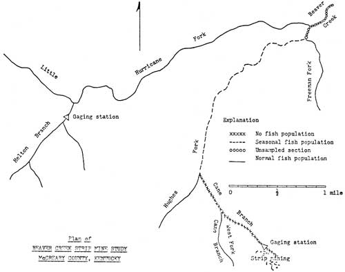
Prior to the meeting, Don Whelan, after extensive reconnaissance of possible study sites on the Cumberland National Forest, had selected a site on the headwaters of Beaver Creek, near the community of Greenwood, which he recommended to the committee. Following a field trip to the recommended area and a study of topographic and soil maps, the group accepted this site.
The site selected was on the extreme headwaters of Beaver Creek, which rises near the junction of US-27 and Ky-90 at the community of Parkers Lake, from several branches or forks which join to form Beaver Creek, which flows through several miles of the National Forest to empty into the upper reaches of Lake Cumberland.
In organizing the study, Helton Branch of Hurricane Fork, which lay entirely within Government ownership, and whose watershed was undisturbed and forested, was selected as the control watershed. Cane Branch of Hughes Fork, whose upper reaches flowed through private land which had been recently strip mined, was selected as the study watershed.
To provide accurate measurement of factors involved, standard U.S.G.S. gaging stations, measuring stream flow, sedimentation and chemical content, were erected on Helton Branch and Cane Branch, and serviced by the U.S.G.S.
This important study continued throughout the period 1955-1959, representatives of all involved agencies participating by handling their assigned studies and by participation in the progress and coordination meeting held in May of each year.
About 1960, it was agreed that sufficient pertinent data had been secured to permit publication of some results, and the study was placed on a maintenance basis pending new disturbance of either watershed or the need for additional information.
The U.S. Geological Survey accepted the responsibility for the publication of results. Publications of information on this study and the information obtained included the following.
Preliminary Reports — Hydrologic Influence of Strip Mining of Parts of the Beaver Creek Basin, Kentucky, by John J. Musser — March, 1961, and Influence of Strip Mining on the Hydrologic Environment of Parts of the Beaver Creek Basin, Kentucky, 1955-1959, in an open file report by Charles Collier — May, 1962.
Professional Papers included — Description of the Physical Environment and of Strip Mining Operations in Parts of the Beaver Creek Basin, Kentucky, Geological Survey Professional Paper 427-A — 1963; Influence of Strip Mining on the Hydrologic Environment of Parts of Beaver Creek Basin, Kentucky, 1955-1959, Geological Survey Professional Paper 427-B — 1964; and Influences of Strip Mining on the Hydrologic Environment of Parts of Beaver Creek Basin, Kentucky — 1955-66. Geological Survey Professional Paper 427-C — 1970.
These professional papers are available for purchase from the Government Printing Office, Washington, D.C.
|
| Plan of Beaver Creek Strip Mine Study, McCreary County, Kentucky (click on image for a PDF version) |
While the results of this study can be said to apply strictly to the specific site of the study, they are a good indication of the general effect and intensity of influence on streams when the watershed is disturbed by strip mining.
Some of the principal indications yielded by this study are: the flood runoff of the stripped watershed exceeded the runoff of the control watershed by as much as 60 percent; the stripped watershed demonstrated less favorable water retention and storage characteristics than the control watershed; the stripped watershed demonstrated approximately twice the 5-year flood potential of the control watershed; the stripped watershed demonstrated a definite detrimental effect on aquatic life; when correlated with the discharge of acid mine effluent, fish life disappeared from the stream within the first year, due to the drastically increased acidity; in individual tests, fish died within 150 minutes of exposure in the acid water (pH 2.9) of the stripped watershed (Cane Branch); in similar individual tests, no mortality resulted from the exposure of fish of the same species to the water of the control watershed (Helton Branch); weathering and erosion of disturbed rock are accelerated on stripped watersheds — on West Cane Branch, sheet erosion from the stripped area averaged 0.7 tons per acre for the 1957-1958 water year; for the 1957-1958 water year, the rates of discharge of sediment were — the stripped watershed (Cane Branch) — 2,800 tons per square mile, the control watershed (Helton Branch) — 49 tons per square mile; and during the period of the study, the average annual sediment yield from the spoil banks per square mile was more than a thousand times greater than the yield from undisturbed areas.
These scientifically measured results have supplied some of the information so badly needed during the Stearns appeal board hearings. The information listed above is only a general summary of the fine documentation contained in the U.S. Geological Survey Reports.
Great credit must go to E. L. Hendricks for the overall guidance and coordination of this study, and for its efficient operation. Similar credit goes to other U.S.G.S. members of the Beaver Creek Work Group Committee — Musser, Collier and Whetstone — for their diligent scientific work on the site, compilation and analysis of data, and for the preparation and publishing of the reports.
This study, accomplished with a minimum of funds, with the contributed time of scientists of 13 agencies, and without any legal organization of the group, has probably provided more useful and usable information for the forest land administrator on the ground than many more detailed and expensive studies. It clearly demonstrates what can be accomplished when technically experienced men and agencies have a real desire to accomplish a task. Much honor goes to all concerned.
Following the placing of the Beaver Creek Strip Mine Study on a maintenance basis, a situation developed which, at first thought, appeared to be a major impact. However, as it turned out, it proved the truth of the motto of the Daniel Boone National Forest, "We have no troubles, only opportunities." Here is what happened.
In the fall of 1965, the State Highway Department initiated a project of straightening and improving U.S. 27 in the vicinity of Greenwood, Ky. It was found that one section of road fill, some 200 feet long and 84 feet high, with a 2:1 slope on the downstream side, would occur within the headwaters watershed of Helton Branch, the control watershed for the Beaver Creek Strip Mine Study. Although the initial phase of that study had been completed, this disturbance would alter materially the conditions in the control watershed.
When the highway improvement project was being planned, staff officers of the Cumberland National Forest met with representatives of the State Highway Department on the ground to identify possible impacts to the watersheds of National Forest streams, and to plan measures to minimize them. It was generally conceded that the construction of the highway fill would result in siltation of Hurricane Fork of Beaver Creek, and particularly in Helton Branch. To insure the reduction of this siltation to a minimum, it was agreed that the construction of this particular fill section would be completed during the fall season, and that a series of small settling basins would be constructed in Helton Branch to catch the sediment. These stipulations were written in the highway right-of-way easement between the State Highway Department and the Cumberland National Forest. The locations for the silt dams were designated and the dams designed by the Forest staff.
As may be expected, things failed to work out according to plan. The highway fill construction was delayed until the winter months, affording no opportunity for revegetating the fill slope draining into Helton Branch. In April of 1965, heavy rains fell. In a period of a few days, around April 13, over two inches of rain fell on the new construction. Although the dry fill absorbed most of this rain, some sediment entered the stream. On April 25, a rainfall of .66 inch occurred, followed by light rains for two days. Then, on the fourth day, April 28, over an inch of rain fell. By this time, the soil of the construction was completely saturated, and most of the rain on the 28th ran off the surface of the fill, carrying a load of loose soil particles with it. Rain continued for several days, continuing to move large sediment loads.
Fortunately, the portion of the Helton Branch Watershed concerned was above the U.S.G.S. gaging station, which was still in operation, and measurement of silt loads was possible. A total of 17 sediment basins had been constructed in Helton Branch which were considered adequate to hold the sediment, had construction and revegetation been completed the previous fall.
During April, 1966, these basins trapped and held about 4,000 cubic feet of sediment. During the same period, over 20,000 cubic feet of suspended sediment passed the gaging station located one mile downstream. Total sediment from this section of highway construction during April of 1966, exceeded 24,000 cubic feet. This was equivalent to the loss of one foot off the downstream face of the 84-foot fill.
During April, 1966, there was 20 times as much sediment moved as was moved during the entire two water years of 1957 and 1958. At the same time, the water flow during April, 1966, was less than one-twenty-sixth of the flow for the total 24 months of 1957 and 1958.
This study illustrates the tremendous amount of sediment that moves into our streams from highway construction. From this, we can faintly imagine the terrific volume of sediment flowing into our streams from the hundreds of miles of strip mine spoil banks and roads throughout eastern Kentucky.
It is fortunate that personnel of the U.S.G.S. and of the Cumberland National Forest recognized the opportunity afforded by this situation, activated the measurement equipment, and followed up with this study. This information can be most useful in demonstrating the effect of construction and strip mining on our watersheds and streams.
With the establishment of the Cumberland Purchase Unit in Kentucky in 1930, little or no activity on the part of the Forest Service took place, as there were few funds or personnel available. With the establishment of the E.C.W. program in 1933, and the establishment of CCC camps, a public education program was initiated, aimed primarily at forest fire prevention and securing support for the Forest Service acquisition program.
In 1941, the first effort was made to provide conservation leadership by the Forest Service for the people of Kentucky. In the late 1930's, the Chiefs office of the Forest Service had employed Mrs. Helen Worth Gorden in their Division of Information and Education for the purpose of providing leadership in forest conservation for women's groups in each of the 14 states of the Eastern Region of the Forest Service (R-7), of which Kentucky was a part. Mrs. Gorden soon found that there were far too many women's organizations in each state for her to be able to deal with effectively. Being a resourceful woman, she developed the idea of a Conservation Council, composed of two representatives from each woman's organization in the state having an interest in conservation, and serving as a coordinating organization for the work of the various conservation interests. In 1940, Mrs. Gorden initiated a test of her idea by founding the Virginia Conservation Council. So successful was this organization, and so well did it enable her to work directly with the conservation leaders of the state, that she immediately turned her attention to Kentucky. By the fall of 1940, she had completed her key contacts to the point that a founding meeting was held at the Kentucky Ridge State Forest near Pineville, Ky., which was attended by about 50 leaders of Kentucky's women's organizations interested in natural resource conservation in the State.
Among the speakers on the program of this meeting were: Richard E. McArdle, Director of the Southeastern Forest Experiment Station at Asheville, North Carolina, later Chief of the U.S. Forest Service, and Roby M. Evans, Regional Forester of the Northeastern Region (R-7), with headquarters in Washington, D.C.
Among the founders of the new Kentucky Conservation Council were a number of women who became strong supporters of the Forest Service program in later years.
Prominent among these were Mrs. J. Kidwell Grannis, Mrs. Fred Wallis, Mrs. Cassius Clay, Miss Daisy Hume, Miss Dudley Hume, and Mrs. Fred Pace.
Although originally conceived as a council composed entirely of representatives of women's clubs, from the beginning the Kentucky Council concept included men as well as women and individuals as well as organizations in its membership. Among the charter members of the new organization were also included Tom Wallace, Robert Blair, Eugene Stuart, H. K. Gayle, Kenneth McConnel, State Forester, Harrod Newland, Asst. State Forester, Harry Nadler, Supervisor, The Kentucky Ridge State Forest, and Harold Borden, Forest Supervisor, Cumberland National Forest.
Tom Wallace, Editor of the Louisville Times and one of the most prominent conservationists in America, became the first President of the Council. Under his aggressive and able leadership, the Kentucky Conservation Council quickly became influential and its voice was heard and respected in the State Capitol and in the halls of Congress. So well did Helen Gorden select, organize and build, that the Kentucky Conservation Council is today still one of the oldest, most respected and active conservation organizations in Kentucky. At present (1974), charter member Harry Nadler, now the State Forester, is President of the Council.
This first venture of the Forest Service in leadership in statewide conservation was an excellent investment which has returned manyfold in the form of conservation leadership in Kentucky, as well as support of Forest Service programs of the Cumberland National Forest. Forest Supervisors of the Cumberland and the Daniel Boone National Forest have continued to remain active members, and have continued leadership through active participation and support in this organization.
In 1953, Forest Supervisor Harold Borden also became a charter member of the Kentucky Agricultural Council, organized in a similar manner and representing approximately 100 agricultural organizations in Kentucky. With the change in Forest Supervisors in that year, Forest Supervisor Robert Collins continued to work actively in the Council. In May of 1955, he presented a statement to the Council on the Forest Resources of Kentucky. In 1957, he was named the Chairman of a Special Forestry Committee charged with developing a long-range forestry platform for Kentucky. Assisted by other forester committee members (Harrod Newland, State Forester; James Newman, State Extension Forester; and Malcolm Williamson, Leader, Berea Research Center), a report was prepared and presented to the Council in October of 1957, which the Council adopted as A Forestry Platform for Kentucky. This was the first long-range forestry plan to be developed for the state.
In 1961, this same committee was named to follow up on the platform and evaluate progress achieved. The committee report was presented to the Council on November 2, 1961.
From the beginning, the administration of the Cumberland National Forest has included the concept of strong statewide leadership and participation in the field of natural resource conservation. While one part of the mission was to develop the resources of the Cumberland to their full potential, the other part was to use the National Forest as a demonstration area of what could be done throughout the state.
With the development of the state Rural Area Development Committee, the Forest Supervisor of the Cumberland National Forest was, of course, a member. The Forest moved promptly, through its representatives, to demonstrate to the state committee, and to representatives of the county committees, some of the means by which the natural resources of the forested counties of eastern Kentucky could develop their resources to their own benefit.
One of the first moves in this direction was the presentation of a statement to the State Policy Committee of Rural Development on the subject, "The Forest Resource Contribution Potential for the Rural Development Program in Kentucky," in December of 1956.
Personnel of the Cumberland utilized every opportunity to present to the leaders and people of Kentucky the opportunity of wildlife development in the state and the economic potential of such development to the counties of eastern Kentucky. One such effort was the presentation of a study, based on data collected in other states, of the potential in eastern Kentucky. This study report was presented to the State Rural Area Development Committee, at one of its regular meetings in 1960. Entitled Deer Values, it created considerable interest throughout the state, and requests for copies came from several adjacent states and from Washington.
Another channel of Forest Service leadership in natural resource conservation was through participation in the various statewide meetings sponsored by the Kentucky Department of Natural Resources.
With the election of Bert T. Combs as Governor of Kentucky in 1961, emphasis and interest in natural resource conservation was given an added impetus. The appointment of J. O. Matlick, formerly owner and editor of the farm magazine, "The Kentucky Farmer," and an ardent conservationist, as Commissioner of the Department of Conservation, initiated a wave of conservation activity throughout Kentucky. One of Commissioner Matlick's first acts was to change the name of the Department of Conservation to the Department of Natural Resources as a means of emphasizing the broad interest of the Department. Commissioner Matlick then called together a group of conservation leaders of the state and organized them into the Kentucky Natural Resources Development Committee, the purpose of which was to bring to the people of Kentucky an understanding of the State's natural resources and how they could best be developed and used to the advantage of all of the people of Kentucky. At the first meeting, Commissioner Matlick was elected Chairman and Mrs. John D. Roberts of the League of Women Voters, Vice Chairman of the Committee. Forest Supervisor Collins represented the Forest Service in this Committee.
It was decided that the initial effort of the committee would be a Conservation Congress, where the leading conservation experts of the state could be brought together with community leaders and others interested in natural resource conservation for a discussion of the natural resource opportunities and problems of the state. As a result, the First Annual Conservation Congress was organized and held in Louisville, Kentucky, on September 28-29, 1961.
Forest Supervisor Collins of the Cumberland National Forest was designated as Chairman of the Forestry Section of the program. Here was an opportunity to bring to the leaders of Kentucky some of the outstanding forestry personnel of the state and nation. As keynoter of the Forestry Section, Supervisor Collins invited Dr. Richard E. McArdle, Chief of the United States Forest Service, who spoke on the subject, "The Role of Forestry in Our State Economy".
In addition to the keynote speech, a three-man panel of prominent foresters participated in a symposium, speaking on subjects supporting the keynote speech. Composing this panel were: Erwin G. Wiesehuegel, Chief, Investigations Branch, TVA, North Tennessee; Dr. Richard L. Lane, Central States Forest Experiment Station, U.S. Forest Service, Columbus, Ohio; and C. D. Dosker, President, Gamble Brothers Timber Industry, Inc., Louisville, Kentucky.
Each of the speakers was outstanding in his field. By bringing foresters of this stature to such a meeting, the image of forestry and the Forest Service in Kentucky was considerably enhanced.
As a measure of the level of the Conservation Congress, the banquet speaker was the Honorable Stewart L. Udall, Secretary of the Interior, Washington, D.C. He was introduced by the Honorable Bert Combs, Governor of Kentucky. This was a most successful beginning of the conservation campaign in Kentucky, and the Cumberland National Forest was firmly established as a part of it.
Encouraged by the success of the initial Conservation Congress, it was decided to make them an annual event. The Second Congress, held in Louisville on October 17-19, 1962, was equally successful. The Cumberland National Forest was again successful in securing Arthur R. Spillers, Director, State and Private Forestry, in the Washington Office of the Forest Service, as the keynote speaker for the afternoon session of the entire Congress. He spoke on the subject, "Forestry in the Overall Conservation Program." In addition, Mr. Spillers participated in the forestry panel, where the Forest Service was also represented by Dr. Carl E. Seliskar of the Forest Service Research Laboratory at Delaware, Ohio. Forest Supervisor Collins of the Cumberland National Forest also participated as a member of the panel on forestry. Again, the U.S. Forest Service played a prominent part in the natural resource affairs of Kentucky.
The Third Annual Conservation Congress was held in Louisville, Kentucky, October 17-18, 1963, featuring the theme, "Water — The Stream of Life." The Forest Service was represented by Forest Supervisor Collins, who served as keynoter of the Congress, speaking on the subject, "Forestry and Recreation Resources of Kentucky," which emphasized the place water quality and uniformity of flow played in the base for recreation, and the part that sound forestry played in determining these factors.
Immediately following this meeting, Forest Supervisor Collins presented a paper at the annual meeting of the Society of American Foresters, held at Boston, Massachusetts, on October 21-24, 1963. The subject presented was, "Fighting Forest Fires with Helicopters," based on the Cumberland National Forest study. Again, the Forest Service was providing leadership in the forestry conservation field.
Participation of the Cumberland National Forest in the Fourth Conservation Congress, whose theme was Youth, Supervisor Collins was a member of the planning committee.
However, 1964 did not slip by without a major public contact by the Cumberland National Forest. On February 28, 1964, Forest Supervisor Collins participated in the Governor's Conference on Forestry, speaking on the subject, "Resource Management."
This presentation emphasized the great need of an organized approach to the management of the natural resources of Kentucky, and pointed out the advantages of multiple use in such management.
The Fifth Annual Conservation Congress was held in Louisville, Kentucky, on October 14-15, 1965. The Forest Service was represented by Supervisor Collins of the Cumberland National Forest, who served as Moderator of the Forestry Panel, and by Dr. Richard Lane, Director, Central States Forest Experiment Station, Columbus, Ohio, who participated as a panel member.
In 1966, the Forest Service continued to exert its leadership in state conservation meetings by participation of top-level people. In February of 1966, Edward Cliff, Chief of the United States Forest Service, came to Kentucky and served as keynote speaker at the Governor's Conference on Forestry, held at the Phoenix Hotel in Lexington, Kentucky. In addition, Douglas Craig, Director, Southeastern Area, State and Private Forestry, of Atlanta, Georgia, served as the luncheon speaker. Forest Supervisor Collins of the Cumberland National Forest served as a member of the planning and arranging committee for the meeting.
On April 17-19, 1966, the Cumberland National Forest was represented by Forest Supervisor Collins, who participated on the program of the Central States Conference on Litter Prevention and Beautification, in Louisville, Kentucky, by presenting a paper entitled, "Litter Control in Recreation Areas."
Early in July of 1966, the Cumberland National Forest served as host for a visit by Michael Fromme, nationally known conservation writer, author of the book, "Whose Woods These Are," and later columnist for the American Forest Magazine. Included in his tour of the Cumberland was an overnight boat trip down the Cumberland River above Cumberland Falls. Mr. Fromme appeared impressed with the scenic resources of the Forest and with the Cumberland's administration of them. After returning to Washington, he wrote the Chief of the Forest Service in support of the Cumberland National Forest for funds to purchase Star Gap Arch in the Red River Gorge area. During the trip, he met a number of Forest officers, with whom he discussed resource administration and with whose resource management philosophy he appeared to agree. As a result of this trip, Cumberland received favorable mention in several of his columns and a writeup entitled "Boone's Woods."
A Sixth Conservation Congress, held in Louisville, Kentucky, October 27-28, 1966, again saw the newly named Daniel Boone National Forest participating actively in the program. In addition to serving as the Director of the Kentucky Natural Resources Development Committee, Forest Supervisor Collins recruited and organized speakers for the Forestry Panel and served as its Moderator. Forest Service leaders participating on the Forestry Panel were E. W. Schultz, Regional Forester, Region 8, Atlanta, Georgia; James B. Strange, Associate Director, Southeast Area, State and Private Forestry at Atlanta, Georgia; and Benjamin A. Roach, Berea Research Center, Berea, Kentucky. Again, the Forest Service had provided strong leadership in natural resource conservation in Kentucky.
In 1967, the Daniel Boone National Forest turned its attention to advancing another resource of the Forest — early Kentucky history. On June 5, 1967, Forest Supervisor Collins presented a talk to about 100 members of Kentucky's most dedicated historical organization, The Filson Club in Louisville, Kentucky, on the subject, "Historic Sites on the Daniel Boone National Forest."
The talk was very well received and was taped by the club for their tape lecture library. It was also printed in its entirety in the January, 1968, issue of the Club magazine, The Filson Club History Quarterly. So many requests were received by the Forest for copies of this talk that additional copies had to be made from time to time. It is known that some individuals have reproduced a great many copies at their own expense for distribution to their friends.
The above information is included to demonstrate the value of the historic resource of the Daniel Boone National Forest and its appeal to people of all ages and of all walks of life. For this reason, the historic resource of the Daniel Boone National Forest should be developed for the enjoyment and information of the public.
On June 13, 1969, the Daniel Boone National Forest again utilized an opportunity to provide leadership in land use and natural resource conservation when Forest Supervisor Collins presented a talk to the State Convention of the Soil Conservation Society of America at Eastern Ky. State University, Richmond, Kentucky. The presentation entitled, "Kentucky's Forests of the Future," outlined the potential of Kentucky's forest land, and pictured the end product of sound development and management in future years. However, it also pointed out some of the obstacles which are encountered, and leaves it up to the people of Kentucky to determine, by their action, how much Kentucky's forest lands will contribute to human welfare in the years ahead.
On December 5, 1969, Forest Supervisor Collins served as a member of a panel discussion of the subject, "Foresters — Yesterday — Today — Tomorrow," before the Annual Meeting of the Kentucky-Tennessee Section, Society of American Foresters. Speaking on the subject, Today's Forester, his paper pointed out the necessity of today's forester dealing with self-appointed, environmental groups with narrow interests and no responsibility for administering results. It also pointed out the necessity of today's forester maintaining a working relation with the press and with the representatives of the major conservation groups.
In March of 1970, Forest Supervisor Collins participated, in company with a group of the I and E staff and of the staff of the Southeast Area, State and Private Forestry, from Atlanta, Georgia, in a panel discussion of the I and E techniques and other information activities which are a part of a forester's work. This presentation was made before the faculty and student body of the Forestry and Wood Technicians' School of the University of Kentucky stationed at Quicksand, Kentucky.
As 1970 and this part of the history of the Daniel Boone National Forest, drew to a close, the Forest had a major opportunity to again provide natural resource leadership in Kentucky. Forest Supervisor Collins was invited to serve as the speaker at the annual dinner meeting of the Kentucky Development Committee at Cumberland Falls, on October 15, 1970.
The Kentucky Development Committee is the present-day successor to the original Rural Development Program State Committee, and is composed of representatives of the major public agencies, both state and federal, of Kentucky. Their responsibility is to guide and facilitate the development of the state in a manner to benefit its people and community, utilizing the resources and programs of all of its respective agencies. Forest Supervisor Collins had been a member of this group since the beginning of the program in the early 1950's. He had repeatedly urged programs for eastern Kentucky to develop the natural resources of the forest land of that area, over 70 percent of the total, as a base for a long-time, self-sustaining economy based on timber industry, wildlife utilization, watershed improvement, and a natural resource-based recreation industry. Over the years, these urgings have brought little response from the Committee members or from the agencies which they represented. In this presentation to the entire Committee, Supervisor Collins summed up the potential of the natural resources of the forest land, which comprises over 70 percent of the land area of eastern Kentucky.
The foregoing outlines the high points of the program of the Cumberland-Daniel Boone National Forest during the period 1950-1970, to provide statewide leadership in the field of natural resource conservation. This phase of the program was handled personally by Forest Supervisor Collins, largely because he represented the Forest Service on the many statewide committees.
Throughout this period, the staff and Rangers were carrying on a similar program at the Forest and Ranger District levels through talks before local service clubs, schools, garden clubs and similar groups. Active participation by District Rangers in the program of the Area Development Councils provided many opportunities to present the basic principles of sound land use and natural resource conservation to local leaders, as well as to the representatives of other public agencies throughout the zone of influence of the Cumberland-Daniel Boone National Forest.
The investment of time and travel made by the Forest is reflected in the public image of the Daniel Boone National Forest in Kentucky today.
This chapter, covering the major activities which comprise the administration of the Daniel Boone National Forest during the period 1950-1970, has, of necessity, presented only the highlights of activity during that period.
The establishment and growth of the Cumberland-Daniel Boone National Forest may well be divided into two, major 20-year periods: 1930-1950, the acquisition and organization period, and 1950-1970, the development period.
What will take place in the next 20 years in the life of the Daniel Boone National Forest remains to be seen. Will public opinion recognize the role of the Forest in the protection and development of the key watersheds of eastern Kentucky, as well as in making these forest lands productive of goods and services, to the point of supporting the expansion and consolidation of ownership to the level where the Daniel Boone can be a major service to the people and communities of the State? Only time and the continued sound administration of the Daniel Boone will tell the story.
The rich historical resource of the Daniel Boone National Forest remains largely unknown to Forest officers, local residents, and National Forest visitors alike. While a few local residents are familiar with a few individual stories handed down in their family or in their community, few have any comprehension of the entire historical background of the area wherein the Daniel Boone National Forest lies, or its significance in the development of this country.
In the summer of 1967, rumors of an ancient campsite under the cliffs in the Red River Gorge filtered into the Office of the Forest Supervisor of the Daniel Boone National Forest in Winchester, Kentucky. Fortunately, the source of these rumors, Roy Reed, was a neighbor of a member of the staff of the Daniel Boone National Forest, Lionel Johnson. It is also fortunate that Staff Officer Johnson has an interest in, and an understanding of, the value of the historical resource of the Forest. Accompanying Roy Reed on a trip to the site, Staff Officer Johnson was convinced that the find of Reed was of great age and of historical significance. His report aroused the interest of Forest Supervisor Collins, who immediately scheduled a visit to the site, after which he set the wheels in motion to learn as much as possible about its historic origin.
The investigation began with Roy Reed, who related the following circumstances. It had long been a habit of Reed, a native of Powell County, but now a resident of Winchester, Kentucky, to roam the more remote portions of the Red River country in search of possible mineral deposits, rare plants or other unusual natural developments. On these trips, he was usually accompanied by his son, Don, and by his father-in-law, Jesse Ashley, of Longbar, Kentucky.
On the particular occasion in question, the group was making its way along the base of a high cliff, deep in the Red River Gorge. After stopping to rest, they were about to continue when one of them happened to look under an overhanging cliff or rock house, which is so common in the Gorge country, and noticed there a small structure of a peculiar nature. Investigating further, it was discovered that the hut was constructed with a pole frame covered with split shakes of red oak laid on the frame in an overlapping pattern, and held in place with rocks laid on the top. Inside the structure, which was about five feet by 10 feet by four feet high, in one corner, was a small rock furnace with the top fashioned to fit the bottom of an iron kettle. Over this furnace, or fireplace, the shakes had been laid in a manner to leave a small opening to permit smoke to escape.
In examining the construction of the hut, which was obviously very old, Mr. Ashley noticed some carving on one of the shakes. Examining it more closely, he was able to make out the letters "D. BOON," which had been formed by outlining them by small dots or stipples made by twirling the point of a large knife. These dimples had then been connected by a carved line.
A further search of the area under the cliff, which was more like a cave, turned up the rusted remains of an old iron kettle, two wooden paddles, a fragment of leather which could have been the remains of a moccasin, and small wood fragments which could have been chips from the split shakes or resulted from the construction of wooden troughs. Also found was about a pound of homemade black powder of a type not made since early pioneer days. In addition, a handmade wooden eating utensil fashioned from a piece of pipe cane with a fork on one end and a spoon on the other was discovered. Nearby the hut were two rock furnaces constructed of sandstone, and portions of three wooden troughs formed by hollowing out portions of logs. The chisel and gouge marks were still plainly visible on these troughs. Between the hut and the face of the overhanging cliff was a pile of sand and sandstone rock reaching from the floor nearly to the roof of the opening and concealing the hut from the view of anyone passing along the face of the cliff. Only by chance and the sharp observation of Mr. Ashley was the hut discovered.
A more detailed search of the area under the cliff revealed markings chiseled into the cliff wall and overgrown with moss and lichens. These markings, which consist of crosses and diagonal marks, resemble some of the marks described by John Swift in his journal as being left as reference marks to the location of the famous silver mine and to the quantities of silver coins and bars which had to be abandoned on his flight from the Indians back to Virginia.
Considering all of these factors, Mr. Ashley believed that he had discovered a site of historic value. He tried to interest a number of officials and individuals, but was apparently unable to describe his find in sufficient detail to convey its real significance. He finally brought the facts to the attention of Dr. Johathan Dorris, Professor of History and Curator of the Museum at Eastern Kentucky University at Richmond, Kentucky. Dr. Dorris, although rather unsteady with age, made the trip down the face of the cliff with Mr. Ashley to view the site. He stated that, in his opinion, it was a camp of great antiquity, and felt that it was definitely connected with the exploration of Daniel Boone. The shake, bearing the "D. BOON," was removed to the University for safekeeping.
This was the status of the story when it came to the attention of the Daniel Boone National Forest in 1967. Staff Officer Johnson and Forest Supervisor Collins made a search of historical writings and maps of early Kentucky in an attempt to obtain a lead to the site and the identity of the individual who had lived there. This search is still continuing. The shake bearing the carving was obtained from Eastern Kentucky University and sent to the Forest Products Laboratory in Madison, Wisconsin, for definite identification of the wood and a possible estimate of its age.
The report from the Forest Products Laboratory confirmed that the material of the shake was red oak and was very old. As to approximate age, no indication was available, as the process of Carbon-14 test is not accurate to closer than a plus or minus one hundred years.
The Forest then contacted Dr. Martha A. Rollingson, Acting Director of the Museum of Anthropology, University of Kentucky, for such assistance as the University could provide. After examining the site and reviewing available information, Dr. Rollingson arrived at four conclusions.
There was no evidence of Indians having used the shelter.
That the items found at the site appeared to have resulted from a short period of use.
That the furnaces and wooden troughs, together with the sandstone rock, possibly indicated an operation to produce "niter" (potassium nitrate) as a base ingredient in the manufacture of gunpowder. In this process, sandstone rock was broken into fragments and placed in boiling water to reduce it to sand. The niter was then leached from the sand by allowing cold water to drip through it. This leached solution was then evaporated and the crystals of niter were obtained for use in the manufacture of gunpowder. Some types of sandstone were said to have yielded as much as 20 to 30 pounds of niter to a bushel of sand. The niter obtained by this method is potassium nitrate, rather than the sodium nitrate or calcium nitrate more frequently produced for this purpose by leaching the soil from the floor of limestone caves.
That exploratory work, to indicate the value of full evacuation, could be done for about four thousand dollars, using the services of an archeologist for a month and six diggers for two weeks.
In addition to the contact with the University of Kentucky, additional contacts were made with the Smithsonian Institution in Washington, D.C.; with the Pennsylvania Historical and Museum Commission in Harrisburg, Pennsylvania; with the Filson Club, and the Kentucky Historical Society in Kentucky in an effort to throw some light on the situation surrounding this historic campsite deep in the Red River Gorge.
Needless to say, the press of the entire nation was interested in this find, which might throw some light on Kentucky's early history. Newspapers throughout the state carried numerous articles and editorials speculating on the origin of this remote camp and on the individuals who built it. Interest was not limited to Kentucky, as many newspapers from adjacent states called for information, purchased news stories on it from local reporters, or actually sent their feature writers to the Daniel Boone National Forest for a tour of the site and an interview with Jesse Ashley, the discoverer.
One such newspaper was the Atlanta Journal and Constitution, which carried a fall news story by Staff Writer Chip Calloway in the issue of Sunday, October 25, 1970. Interest in this situation continues to exist.
A measure of the national interest in the story of the D. Boon Hut is the interest shown by national television. After making arrangements for their visit by telephone, Charles Kuralt of CBS News brought his camera crew to the Daniel Boone National Forest and filmed scenes in the Red River Gorge and at the D. Boon Hut campsite, as well as filming his interview with Jesse Ashley. To Mr. Kuralt's question as to the circumstances under which he found the site, Mr. Ashley replied, "We walked around the cliff and Don looked over there and he said, 'Well, lookee a here. I seen some old logs over there with some wooden pegs drove in 'em'. I said, 'Yeah, and look on down there. I see a cabin', and he liked to fell over. I reached over here and Joe, he come over and he picked this board up like this and turned it over and there was D. Boon's initials on there. I told him that was just like what was on D. Boon gunstocks, and that's just bound to be his initials. Did you ever see that . . . anything like it in your life before? Did you ever see Daniel Boone's initial on a gunstock?"
The taped TV program was presented to the nation on Tuesday, April 2, 1968, on Walter Cronkite's CBS news broadcast. Much interest and many letters resulted, including an acknowledgement from Glenn A. Kover, Director, U.S. Forest Service Motion Pictures, Radio and Television Unit in Pasadena, California. The Daniel Boone National Forest really received nationwide coverage on this one.
In the middle of this wave of nationwide acclaim at the discovery of the D. Boon Hut, a bombshell was tossed by a local resident of Powell County.
On April 12, 1968, about a week following the CBS News broadcast, Henry Catron, age 47, of Powell County, told District Ranger Robert Brooks that the story was in error, and that he and his younger brother, Hugh, age 45, had built the cabin while playing in the Gorge some 35 years previously. Taken to the site by Ranger Brooks, Henry Catron admitted that it, "didn't look exactly as I remembered it." When contacted by Ranger Brooks, Hugh Catron, the younger brother, denied helping to construct the hut or being in that location as a boy. However, this story was soon cleared up when Ranger Brooks, following Henry's description of the cave where he had built the shelter as a boy, located near a branch, found that site and the crude shelter built with small poles in another location less than a quarter of a mile from the original site. That cleared up the situation.
With their interest aroused almost to a fever pitch, Supervisor Collins and his staff searched through old histories, journals of the 1700's in Kentucky, old family records and interviewed local families, as well as newswriters, on early Kentucky history and folklore. One such writer, Nevyle Shackelford, an employee of the University of Kentucky and a special feature writer for the Lexington Leader newspaper, visited the site and assisted in every way in the inquiry as to the origin of the D. Boon Hut.
These sources exhausted, Forest Supervisor Collins and his staff reviewed all findings, data and historical facts assembled, and evaluated them in the light of known history, corresponding dates and times of certain events and circumstantial evidence.
These facts and factors were considered:
John Swift and his silver exploration party came to Kentucky each summer, 1761 — 1769.
Evidence is strong that the Red River Gorge was one location of their summer headquarters.
The site of the Boon Hut was ideally situated for such a camp: it was in a remote arm of the Gorge and it was located in the face of the cliff, well above the valley floor, yet at the base of a sheer cliff nearly 100 feet in height.
It was difficult to locate from a distance of greater than 100 feet.
Access to it was limited to a narrow ledge along the face of the cliff.
It was well off the normal travel route of Indians and was easily defended by a few longrifles, if discovered and attacked.
During most of the year, a small waterfall came directly over the entrance from the cliff above, providing for water and concealment.
The area under the overhanging cliff was very dry — the dust of ages covered the floor and the rocks. It was apparent that it was not used by Indians.
During the winter months, the area under the cliff was warm — when photographing the hut, coats needed to be removed for comfort.
The cross-and-hash marks on the wall has been there many years, as indicated by moss and lichens covering them.
The marks were similar to those described in John Swift's journal as reference marks to locations where he buried silver coins and bars when pursued by the Indians.
The location was only about 20 miles, as the crow flies, from the location of Daniel Boone's base camp established at the mouth of Red Lick on Station Camp Creek early in June, 1769.
The last known trip of the John Swift silver mine party to Kentucky was in the spring of 1769.
This means that the Swift party and the Boone party were living and travelling in the same general area at the same time.
It is known that Daniel Boone had a habit of carving his name on some object at key points — trees, rocks, and even his own rifle stock.
History tells us that Daniel Boone did not spell his name with the final "e" until after he came to Boonesborough in 1775.
The arrangement of the letters in the word "BOON" is the same as used in known carvings of his name. The slender sweep of the curved portion of the "D" with the vertical line slanted slightly to the right. In the word "BOON", both the "B" and the "N" are capital letters, while both the "O's" are lower-case letters. This is characteristic of Daniel Boone's spelling and carving of his name.
The late Judge Edward C. O'Rear often spoke of a tree in Morgan County, where he was at one time a resident, on which was carved "D. BOON". This tree was located in the Elk Fork Creek section of Morgan County, beyond the Scout Cave.
After assembling all possible reference material and noting circumstances that appeared to be more than coincidence, the Daniel Boone National Forest has come to believe, in the absence of evidence to the contrary, that the story of the Boon Hut is as follows.
The Boon Hut is the site of the headquarters of the John Swift silver mine party while they were in Kentucky in 1769. While Boone and his companions were exploring the country from their base camp at the mouth of Red Lick, less than 20 miles from the Boon Hut site, they made contact with the Swift party, and possibly spent the night at their camp. A woodsman of Boone's skill, ranging widely in wilderness country, would be sure to detect the presence of other white men who were as active in their exploration as Swift's silver mine party. While Boone does not mention such a contact, it is possible that he agreed with the Swift party to refrain from such mention in the interest of keeping the location of the camp (and possibly the mine) a secret. Knowing the location of this secret camp in the Red River Gorge, it is most likely that Daniel Boone used it many times on his hunting expeditions to that area.
It is not unlikely that Boone may have used this site for his base camp in the early summer of 1770, while his brother, Squire, took the packhorses and the furs and skins back to the settlement to sell and return with fresh supplies. The secluded site would have been ideal for Boone to have concealed his presence from Indians and used as a base camp during that period.
While the above story of the Boon Hut is based partly on recorded fact and partly on circumstantial evidence, it is the story the Daniel Boone National Forest believes, and will continue to tell, until better evidence to the contrary is produced. The circumstantial evidence is strong — men have been hanged on less.
Immediately after the news stories were published and the CBS broadcast of Charles Kuralt on the Walter Cronkite CBS News, the Forest was besieged by all types of people wanting to visit the site. It is suspected that many believed this to be the site of the famous Swift silver mine. It was apparent that fast work would be required on the part of the National Forest to save the site from being destroyed by the public. One of the Forest Service engineers, with a crew of workmen, started at once to protect the site by a strong fence composed of steel posts extending from the rock floor to the rock ceiling and connected laterally with steel bands. They worked continuously through the weekend to complete the job.
Although the location of the Boon Hut had never been given in the press or on TV or radio; and, although it was necessary to scramble over a hundred feet of nearly vertical cliff to reach the site, in excess of 150 people visited the site where the crew was working on a single Sunday.
On completion of the fence, a foot trail, nearly a mile in length, was constructed leading from the Gray's Arch parking area, located on Tunnel Ridge Road, to the Boon Hut site. A Forest Service sign located at the beginning of the trail identifies it to the public. Many hundreds of Forest visitors follow this trail to view the Boon Hut each year. This popularity of the Boon Hut well illustrates the attraction of the historic resource of the Daniel Boone National Forest for the people of Kentucky.
Only those Foresters who have been privileged to occupy the position of District Ranger or of Forest Supervisor on one or more of America's National Forests can fully realize the awesome responsibility of these positions, or the great professional pride which results from successfully accomplishing such administration jobs.
A District Ranger or a Forest Supervisor realizes that the people of the United States have entrusted him with the protection, development, and sound and efficient administration of the many natural resources of the land for which he is responsible.
These lands are a part of the national heritage of the American people. They must be administered in a manner that will yield a maximum of their potential to the advantage of all of the people in the form of goods and services. The Forest administrator must also continue to provide leadership in natural resource conservation, translated into the language and the understanding of the local people, while utilizing the Forest land he administers as a living demonstration of the results of good conservation practices.
In addition, he must insure that all actions of the organization for which he is responsible, including his own, are fully in compliance with the laws and regulations of the United States, and with the policies and operating procedures of the U.S. Forest Service.
This is a most responsible job, requiring not only technical knowledge, administrative skill and the ability to get things done, but a certain kind of strong, personal leadership which will influence people, both in his own organization and among the general public.
The U. S. Forest Service has included many people with these capabilities since its organization at the beginning of the century. The original organizer of the U. S. Forest Service, and the father of American forestry, Gifford Pinchot, was such a leader. He required no skills, labor or hardship from his subordinates which he was not willing to provide or undergo personally. His example founded a tradition in the U. S. Forest Service which has endured to the present day.
From the establishment of the Cumberland Purchase Unit in 1930 to the present time, its development and administration have been directed by men of the U. S. Forest Service whose professional skill, administrative ability, and public leadership, coupled with a basic personal integrity, have won the approval and the admiration of the people of Kentucky with whom they have been associated. The public image of the Daniel Boone National Forest in Kentucky today is the cumulative result of the performance of the hundreds of individuals who have served on the Forest during the past 40 years, and particularly a tribute to those Forest officers who bore the responsibility of the position of District Ranger and of Forest Supervisor.
Listed on the following pages are the names of the Forest officers who have occupied these key administrative positions on the Cumberland and Daniel Boone National Forest during the past 40 years, together with the location and period of service of each.
FOREST SUPERVISORS
CUMBERLAND-DANIEL BOONE NATIONAL FOREST
| Initial Acquisition Project | |
| 1930 — 1933 (3 years) | — W. E. Hedges |
| 1933 — 1934 (1 year) | — W. L. Kramer |
| 1934 — 1936 (2 years) | — C. L. Graham |
| 1936 — 1939 (3 years) | — R F. Hemingway |
| 1939 — 1953(14 years) | — H. L. Borden |
| 1953 — 1970 (17 years) | — R. F. Collins |
| 1970 — 1974 (4 years) | — J. E. Alcock |
| 1974 — | — R. H. Wengert |
MOOREHEAD RANGER DISTRICT
Established — December, 1933.
District Headquarters — Initially at Mt. Sterling, Morehead After 1941.
First District Ranger — Alfred H. Anderson.
Original District Name — Red River District.
District Name Changed to Morehead Ranger District in 1958.
Gross Area as of Proclamation in 1937 — 460,000 Acres.
District Boundary — All land within the Proclamation Boundary north
of the Kentucky River.
Area Adjustment — The portion of the District south of US-460 was
detached to form the Stanton District in 1960.
DISTRICT ADMINISTRATION
| District Ranger | From | To |
| Ephe M. Olliver | 12/33 | 7/35 |
| Karl M. Stoller | 7/35 | 6/44 |
| John R. Hicks | 6/44 | 6/48 |
| George E. Nietzold | 6/48 | 12/55 |
| Seymour G. Hile | 12/55 | 8/56 |
| Charles C. Elsbree | 8/56 | 11/60 |
| Herbert R. Steidel | 11/60 | 6/62 |
| Robert A. Reynolds | 7/62 | 4/68 |
| Richard J. Bonyata | 4/68 | — |
STANTON RANGER DISTRICT
Established — October, 1960.
District Headquarters — Stanton, Kentucky.
First District Ranger — Bernard J. Schruender.
Original District Name — Stanton Ranger District.
Formed in 1960 From That Part of the Morehead District south of US-460.
District Boundary — All land within the Proclamation Boundary south
of US-460 and north of the Kentucky River.
DISTRICT ADMINISTRATION
| District Ranger | From | To |
| Bernard J. Schruender | 10/60 | 5/65 |
| Robert G. Brooks | 5/65 | 8/70 |
| Harry D. McCutcheon | 8/70 | 6/73 |
| Don F. Fig (Acting) | 6/73 | 1/74 |
| John W. Moore | 1/74 | — |
BEREA RANGER DISTRICT
Established — April, 1935.
District Headquarters — Berea, Kentucky.
First District Ranger — Bernard A. Eger.
Original District Name — Rockcastle Ranger District.
District Name Changed to Berea Ranger District in 1958.
Gross Area as of Proclamation in 1937 — 377,283 Acres.
District Boundary — All land within the Proclamation Boundary south
of the Kentucky River and north of US-25.
DISTRICT ADMINISTRATION
| District Ranger | From | To |
| Bernard A. Eger | 4/35 | 11/35 |
| Bruce E. Mansberger | 11/35 | 10/36 |
| Chester L. Kinney | 11/36 | 10/40 |
| Noyes D. Shirley | 10/40 | 3/42 |
| Earle H. Meekins | 4/42 | 5/47 |
| Noyes D. Shirley | 6/47 | 7/51 |
| Seymore G. Hile | 7/51 | 12/55 |
| John F. King | 12/55 | 6/72 |
| Kirby A. Brock | 7/72 | — |
LONDON RANGER DISTRICT
Established — February, 1937.
District Headquarters — London, Kentucky.
First District Ranger — Bruce E. Mansberger.
Original District Name — Sublimity District.
District Name Changed to London Ranger District in 1958.
Gross Area as of Proclamation in 1937 — 83,533 Acres.
District Boundary — All land within the Proclamation Boundary south
of US-25 and north of the Laurel River and Lake Cumberland.
DISTRICT ADMINISTRATION
| District Ranger | From | To |
| Bruce E. Mansberger | 2/37 | 10/40 |
| Karl W. McNasser | 10/40 | 9/42 |
| Ephe M. Olliver | 9/42 | 8/43 |
| John R. Hicks | 8/43 | 6/44 |
| Seldon W. Campbell | 6/44 | 10/46 |
| Karl W. McNasser | 10/46 | 6/47 |
| Seldon W. Campbell | 6/47 | 6/48 |
| Edward L. Hurst | 6/48 | 8/49 |
| Seldon W. Campbell | 8/49 | 7/56 |
| Joseph W. Fromme | 7/56 | 9/58 |
| Noel K. Sheldon | 9/58 | 10/60 |
| Charles G. Bartlett | 10/60 | 6/70 |
| Jack E. Reichert | 6/70 | 10/74 |
| Donald K. Kight | 10/74 | — |
SOMERSET RANGER DISTRICT
Established — January, 1952.
District Headquarters — Somerset, Kentucky.
First District Ranger — Harold H. Bush.
Original District Name — Pulaski District.
District Name Changed to Somerset Ranger District in 1958.
District Formed From a Part of the Laurel District in 1952.
District Boundary — All land inside the Proclamation Boundary,
which is north of KY-90 and KY-927, west of Lake Cumberland and the
Rockcastle River, and south of KY-80.
DISTRICT ADMINISTRATION
| District Ranger | From | To |
| Harold H. Bush | 1/52 | 3/57 |
| Arthur T. Leach | 3/57 | 3/58 |
| Wayne E. Ruziska | 4/58 | 9/62 |
| Everett L. Towe | 9/62 | 3/65 |
| Danny W. Hile | 3/65 | 12/67 |
| Robert O. Harllee | 1/68 | 6/74 |
| Jack F. Steelmon | 6/74 | — |
STEARNS RANGER DISTRICT
Established — April, 1935.
District Headquarters — Stearns, Kentucky, moved to Whitley City, fall of 1964.
First District Ranger — Alfred H. Anderson.
Original District Name — Laurel District.
District Name Changed to Stearns Ranger District in 1958.
Gross Area as of Proclamation in 1937 — 427,400 Acres.
District Boundary — All land within the Proclamation Boundary south
of the Cumberland River and the Laurel River.
Area Adjustments — 1947 — Area south of Laurel River and east
of the Cumberland River and Marsh Creek withdrawn and established as the
Jellico Ranger District.
1952 — Area north of KY-90 and KY-927, west of Lake Cumberland and
the Rockcastle River and south of KY-80 withdrawn and established as the
Pulaski Ranger District.
DISTRICT ADMINISTRATION
| District Ranger | From | To |
| Alfred H. Anderson | 4/35 | 6/35 |
| Ephe M. Olliver | 7/35 | 6/38 |
| Ralph O. Smoot | 6/38 | 8/43 |
| Wilson J. Mitchell | 8/43 | 11/45 |
| Ralph O. Smoot | 11/45 | 6/48 |
| Seldon W. Campbell | 6/48 | 8/49 |
| Edward L. Hurst | 8/49 | 8/54 |
| Stanley H. Ockers | 8/54 | 8/56 |
| Carl E. Burgtorf | 9/56 | 9/60 |
| Noel K. Sheldon | 10/60 | 6/62 |
| Herbert R. Steidel | 6/62 | 10/67 |
| Sam A. King | 10/67 | 1/70 |
| Glen W. Kile | 1/70 | — |
WILLIAMSBURG RANGER DISTRICT
Established — June, 1947.
District Headquarters — Williamsburg, Kentucky.
First District Ranger — Earle H. Meekins.
Original District Name — Jellico District.
District Name Changed to Williamsburg Ranger District in 1958.
District Formed From a Part of the Laurel District in 1947.
District Boundary — All land within the Proclamation Boundary south
of the Laurel River and east of the Cumberland River and Marsh
Creek.
Area Adjustment — 1970 — District deactivated and land
incorporated in the Stearns and London Districts.
DISTRICT ADMINISTRATION
| District Ranger | From | To |
| Earle H. Meekins | 6/47 | 5/58 |
| Walter A. Guerrero | 5/58 | 4/62 |
| Everett L. Towle | 4/62 | 9/62 |
| Thomas R. Frazier | 9/62 | 9/65 |
| Joseph Hedrick | 9/65 | 2/68 |
| Richard J. Bonyata | 2/68 | 4/68 |
| Harry D. McCutcheon | 5/68 | 8/70 |
REDBIRD RANGER DISTRICT
Established — July, 1965, as a Purchase Unit.
District Headquarters — Manchester, Kentucky, moved to Peabody, Ky., in 1966.
First District Ranger — Thomas R. Frazier.
Original District Name — Redbird Purchase Unit.
District Name Changed to Redbird Ranger District.
Gross Area as of 1972 — 687,061 Acres.
District Boundary — Purchase Unit boundary.
DISTRICT ADMINISTRATION
| District Ranger | From | To |
| Thomas R. Frazier | 7/65 | 12/69 |
| Sam A. King | 12/69 | 6/71 |
| James D. Lunsford | 7/71 | — |
Other Personnel
Following, in tabular form, is a record of other key personnel who have served on the Cumberland-Daniel Boone National Forest in key positions, and whose contributions have contributed materially to the development of the National Forest and to its contribution to the people of Kentucky:
SERVICE ON THE CUMBERLAND -
DANIEL BOONE NATIONAL FOREST
| Forest Engineers | Administrative Officers |
|
A. T. Kendrick James T. Hall Frank J. Hammond Van LaBoon Glen Bonar |
William J. Elliot John C. Claman William S. Avelar Walter R. Hudgens Michael J. Noordewier Jack Hatfield |
| Key Supervisor Office Staff | |
|
Bruce E. Mansberger Seymour G. Hile William W. Wentz Alan R. Duhnkrack Everett Towle Joe R. Griffiths Stanley H. Ockers Carl E. Burgtorf Jim O'Keefe Lionel R. Johnson Robert A. Reynolds Deputy Forest Supervisor Leonce A. Cambre, III John W. Korb, Jr. Ranger District Clerks Morehead District Hazel D. Ramey Katie R. Maze J. Maxine Stephens Stanton District Katie R. Maze Wilda R. Derickson Berea District Ruth B. Stafford Connie Hendricks Charlotte Moore Doris J. Gish |
London District Sue Taylor Martha A. Hunt Somerset District Iris W. Glass Sarah J. Gooch Catherine F. McQueen Joyce Wilson Betty Lair Donna Cromer Betty Lair Janice G. Davenport Stearns District Andy E. Griffith Barbara Gilreath Don Waters Brenda W. Martin Williamsburg District Lucy Witt Jo Elizabeth Bryant Linda Brewer Redbird District Sandra R. Conner Carolyn S. Mills |
In every successful organization, there are certain personnel who have served faithfully and well for many years. They are the reliable people who do the day-to-day primary jobs and do them so well they are taken for granted. In the Cumberland-Daniel Boone National Forest, the faithful and efficient service of the following individuals has contributed much to the operation and administration of the Forest over a long period of time:
Forest Supervisor's Office
| Jean Whiteside Hudgens Evelyn S. Powell Otella R. Witt |
Ruth B. Stafford Mildred Green Reed D. Gene Carter |
Field & Road Crew
| Troy N. Anderson Jess Francis Ball Hagon Barnett Leonard F. Brewer Stanley Fields George Freeman Paul Gilreath Andy E. Griffith Archie Griggs Kermit Hale Scott W. Hale Leonard Hicks |
Morris Johnson Berlin J. Knox Espie C. McCarty Everett T. Mason Joe J. Mauk Ledford E. Perry Albert W. Standau Elmer Sumner Luther Vanzant Vester Wright Clarence E. Henson Gotto Patierno Frank Roberts |
In addition to these loyal members of the Cumberland-Daniel Boone team, many others have contributed, and are still contributing, to maintaining the everyday operation of the Forest. All honor to them for their faithful service.
It is obviously impossible to recognize by name the hundreds of Forest officers who have contributed much to the development of the resources of today's Daniel Boone National Forest. However, it is most fitting that mention be made of a few individuals whose administrative skill and devotion to public service contributed much to establishing the foundation of the Daniel Boone National Forest of today.
W. E. Hedges
Undoubtedly, the reconnaissance reports on eastern Kentucky, prepared by W. E. Hedges in the late 20's and early 30's, were a major factor in the selection of the area which comprised the original Cumberland Purchase Unit for that purpose. From the establishment of the Purchase Unit in 1930 to the assignment of the first Forest Supervisor in 1933, W. E. Hedges guided the organization and establishment of the unit headquarters and the initial acquisition force. As a key Lands Staff Officer in the Regional Office of Region 7, first in Washington, D.C., and later in Philadelphia, Pennsylvania, he continued to guide the land purchase program of the Forest until his retirement in the 1950's. The Forest Service, and the Daniel Boone National Forest, owe much honor to W. E. Hedges for his wise guidance of its land's foundation of its land purchase policies.
Espie C. McCarty
During a career of about 30 years on the Cumberland National Forest, Espie C. McCarty probably contributed more to the clearing up of land titles on the Forest than any other individual.
Starting with only a moderate education, McCarty was attracted by the concept of a National Forest in Kentucky. Starting as an axe man on one of the first acquisition surveying crews in 1933, he determined to make work on the National Forest a career. Attracted initially by the techniques of surveying, he qualified himself in land surveying through correspondence courses and other self-study. Progressing as he worked, he moved into the field of land description and land titles. Working with title attorneys on land records in county courthouses, we well as with local residents, McCarty became an authority on land titles and descriptions on the Cumberland to a point that his signature on a land description was accepted without question in the Washington Office and by many Federal judges. He served as an expert witness in courts on hundreds of land boundary dispute bases. His testimony and evidence were never found to be incorrect or faulty.
Espie's loyalty to the Forest Service, and particularly to the Cumberland National Forest, was unsurpassed. His contributions to the Forest, not only in its early days, but throughout his career, were beyond measure and evaluation. The Forest Service and the Forest are better today because of the devoted work of Espie McCarty.
Bruce E. Mansberger
Bruce E. Mansberger came to the Cumberland National Forest in its early days. He had been a forester employed by the Ritter Lumber Company prior to joining the Forest Service. He served as the second District Ranger of the Berea District from 1935 to 1936, moving to the London District in 1937, as its first District Ranger. He was the District Ranger at London throughout the major part of the life of the Sublimity Resettlement Project, serving as the Forest Service representative. At the beginning of World War II, he became the Timber Management Staff Officer in the Forest Supervisor's Office in Winchester, where he directed the timber production program on the Cumberland National Forest throughout World War II. Early in 1956, he accepted a position in the Regional Office, Upper Darby, Pennsylvania, in the Division of State & Private Forestry, where he remained until his retirement. His contribution to the establishment of a sound forest management program on the Cumberland National Forest was outstanding.
A. T. Kendrick
A. T. Kendrick came to the Cumberland National Forest in the early 1930's as an engineer, and soon advanced to the position of Forest Engineer, which he held until his retirement in 1955. During the early acquisition period, he was in charge of the triangulation survey which established the base for the surveys on the Forest. During the CCC days as Forest Engineer, he designed and supervised the construction of many of the larger bridges in the Forest, as well as supervised the construction of roads, lookout towers, buildings and other improvements. The quality and soundness of his work are attested to by the fact that many of his structures are still in serviceable condition. He was a fine individual, an excellent engineer, and a pioneer of the Cumberland National Forest.
Henry F. Sipe
Another pioneer of the Cumberland National Forest was Henry F. Sipe. Coming to the Cumberland as Assistant Forest Supervisor in the early 1940's, Henry Sipe immediately established himself by the organization of an aggressive forest fire control program. Applying his technical knowledge and administrative capability, he soon became recognized as a strong leader in the field of forest fire control in Region 7. A frequent contributor to Fire Control Notes and the Journal of Forester, his name and the Cumberland National Forest were known throughout forest fire control organizations of the country. His actions were a major contribution in gaining control of the forest fire situation on the Cumberland National Forest. Transferring to the Monongahela National Forest in West Virginia in 1953, he remained there as Deputy Forest Supervisor until his retirement in the 1960's.
John R. Ridnour
Another pioneer of the Cumberland National Forest was John Ridnour. John came to the Forest Service through the CCC program. He was a Construction Foreman and later was Camp Superintendent of CCC Camp F-14, located at Bell Farm in the Laurel Ranger District.
Following the close of the CCC program, John became a foreman of construction and maintenance on the Forest. While his job was primarily that of the road maintenance program, his help in many fields, from obtaining rights-of-way to lookout tower construction, was of great assistance to the entire Forest. John continued in this capacity, working under the Forest Engineer, until his retirement in 1970. The Daniel Boone is a better place to work today because of the many contributions of John Ridnour. He was typical of the devoted, nonprofessional, Forest Service members who have contributed so much to the development of the Forest from 1933 to the present day.
The Forestry Aids
With the close of World War II, District Rangers were assigned one or more assistants, who were given the title Forestry Aid. This title well described the work of these individuals. They served in every possible capacity on the Ranger District from fire dispatcher to foreman of trail crews to fire crew leaders. The individuals selected for these assignments were, for the most part, former CCC employees who had demonstrated special qualifications required while in the CCC program. Their record of loyalty and service during the next 20 years certainly justifies their selection. While Rangers and professional Foresters have come and gone, these individuals remained on the Districts and provided the continuity, the local contact, and the know-how to keep the District functioning efficiently. Without their continued loyalty, their skill in guiding District programs their council and assistance to Rangers, and the respect they commanded in the local community, the Forest would not be as well established or have the public image in the local community as it has today. Without these Forestry Aids, many a new Ranger would have had a most difficult experience in becoming familiar with the District, and in becoming established with the local community. These men were truly the anchormen of the District. All honor to them and the outstanding jobs they have performed over the years.
These Forestry Aids and the Districts on which they served are as follows:
The Red River Ranger District
Joe J. Mauk
Clarence E. Henson
The Rockcastle Ranger District
Paul Gilreath
The Sublimity Ranger District
Morris C. Johnson
A. W. Standau
The Laurel Ranger District
Ledford E. Perry
Espie C. McCarty
Andy E. Griffith
The Jellico Ranger District
Gotto Patierno
The Pulaski Ranger District
Elmer Sumner
| <<< Previous | <<< Contents>>> | Next >>> |
|
region/8/daniel-boone/hsitory/chap35.htm Last Updated: 07-Apr-2010 |