|
Senate Document 84 Message from the President of the United States Transmitting A Report of the Secretary of Agriculture in Relation to the Forests, Rivers, and Mountains of the Southern Appalachian Region |
|
REPORT
ON THE
FORESTS AND FOREST CONDITIONS OF THE SOUTHERN APPALACHIAN MOUNTAIN REGION.
|
To the PRESIDENT: An interest in practical forestry, notable and commendable, has grown up among the American people during the past few years. There is an evident determination that our country shall profit from its own and the experience of other countries by beginning the preservation of our forest remnants before it is altogether too late. The most important practical outcome of this awakening has been the setting aside by the Government, out of the public domain, in the several Western States and Territories, of some 70,000 square miles of forest-covered lands about the mountains in these regions, to protect the streams and perpetuate the timber supplies. A more recent result is the movement, which has met with the general approval of business and scientific organizations and the unanimous support of the press, toward the preservation by the Government of the hard-wood forests on the slopes of the Southern Appalachian Mountains. The proposal that the Government shall protect these Appalachian forests by purchasing the lands and making of them a great national forest reserve was first brought directly to the attention of Congress in January, 1900, when a memorial to that effect was presented by the Appalachian Mountain Club of New England and the Appalachian National Park Association of the South Atlantic States. In response to this memorial and in recognition of the importance of the movement, the act making the appropriation for the Department of Agriculture for the fiscal year ending June 30, 1901, provided that a "sum not to exceed $5,000 may, in the discretion of the Secretary of Agriculture, be used to investigate the forest conditions in the Southern Appalachian Mountain region of western North Carolina and adjacent States;" | |||||
|
Acting under this authority I conducted such an investigation during the field season of 1900, and continued it again during the present year. The conclusions to which the results of this investigation have led me will be found at the end of this report (p. 38). | |||||
|
Departments of Agriculture and of the Interior cooperate in the investigation. |
By the liberal cooperation of the Department of the Interior, through United States Geological Survey, I was enabled to make these investigations much broader and more thorough than would otherwise have been possible. The Geological Survey, in timely recognition of the importance of this movement has, during the past two years, studied the topographic features and the water supplies of the region in relation to its forest development, and has also cooperated in the examination of the forests themselves. The investigations along the several lines have been participated in by the best men available in the Government service. I have myself twice visited this region, and have seen at first hand the destruction of the forests and the consequent enormous damage by floods; have examined some of its largest mountain masses, and have climbed its highest peak. The conclusions reached from this personal experience, as well as from the extensive expert investigations just mentioned, will be found briefly summarized at another place in this report (p. 38). | ||||
|
Nature of the investigation. |
The experts in charge of this work examined not only the forests and the general forest conditions as they exist to-day but also the causes which have led up to these conditions and the possibility of improving them either with or without Government ownership and supervision. They studied the influences of the forests on the preservation of the streams and soils of these mountains and on the preservation of the water powers and the farm lands along these streams, both within the mountain areas and across the bordering lowlands. In particular the region was studied as to its relative adaptability to future development along the lines of practical forestry and practical agriculture. | ||||
|
Forest and agricultural conditions. |
The forests were carefully mapped as to their distribution and density and the relative proportion of the forest-covered and cleared lands. The investigation also included a study of the general character and distribution of all the available species of trees and shrubs of the region, the stand of timber, the extent to which the timber has been and is now being cut or damaged by fire, the nature of the present holdings, and the prices at which these lands can be purchased. The agricultural investigation included the study of the cleared lands, methods of their clearing, the crops which they yield, and the extent to which these lands deteriorate by erosion and by the leaching out of their fertility both on the mountain slopes and in the valleys. | ||||
| |||||
|
Investigation of the streams. |
The officers of the Geological Survey meanwhile made a careful study of the quantity of water flowing out through the various streams having their sources in this region, and of the effect of forest clearings on the regularity of their flow at different seasons. Fifty-four regular stations were maintained, covering every large stream which rises in these mountains. These streams flow through West Virginia, Virginia, North Carolina, South Carolina, Georgia, Alabama, and Tennessee, and rank among the important rivers of the country. At each station daily records of stream heights were kept, and measurements of the volume of flow were made from time to time. In addition to this, more than 1,000 miscellaneous gagings were made on the tributaries of the James, Roanoke, Yadkin, Catawba, Broad, Savannah, Chattahoochee, Coosa, Hiwassee, Tennessee, French Broad, Nolichucky, Watauga, Holston, and New (Kanawha) rivers. (See Pl. XII). | ||||
|
Nature of this report. |
A brief preliminary report embodying the more salient results of this investigation during the year 1900 was sent to Congress by the President in January, 1901. It was accompanied by a letter from President McKinley commendatory of the plan for an Appalachian forest reserve here suggested anew. The present report will be found to contain the results of the investigations carried on during the past two years, together with some conclusions based upon them. The general statement is followed by a series of supplemental papers, each containing a more detailed account of the results of the examinations and inquiries along some one single line. | ||||
|
The region examined. |
The region examined during this investigation embraces that part of the Appalachian Mountain system which begins in southern Virginia and includes portions of that State, of southeastern West Virginia, western North Carolina, eastern Tennessee, northwestern South Carolina, and northern Georgia, and especially that portion of this region usually designated as the Southern Appalachian Mountains. Its general character and relations can be more easily described and better understood after a brief discussion of the Appalachian region as a whole. | ||||
|
Appalachian Mountains. |
The map accompanying this report (Pl. II) shows the Appalachian Mountain system extending along the eastern portion of the continent from New York to Alabama, for a distance of 1,000 miles, and having a maximum width approaching 150 miles. These Appalachians constitute, not a single ridge or chain, but a zone or belt of mountains, the maximum development of which is reached south-southwest of Washington. Along the southeastern front, the Blue Ridge Mountains in New Jersey and Pennsylvania are rather poorly defined, and reach an elevation in the latter State, at South Mountain, of about 2,000 feet. South-southwestward they become a more prominent and regular feature in the landscape, the highest peaks reaching an elevation of a little more than 4,000 feet in Virginia (see Pl. XII), and about 6,000 feet in North Carolina. Along the northwestern front of this belt the Allegheny Mountains, starting with the Catskills in New York, cross Pennsylvania and Maryland is a series of well-defined parallel ridges, with a general elevation of 2,000 feet. The maximum development of the Alleghenies, however, is reached along the line between Virginia, West Virginia, and Kentucky, where the elevations range from 3,000 feet to nearly 4,500 feet above the sea. Southward from this point they become less and less prominent, rising but little above the adjacent plateau surface. | ||||
| |||||
|
Appalachian Valley. |
Between the Blue Ridge Mountains and the Alleghenies lies a great mountain valley, or succession of valleys, separated laterally by more or less subordinate ridges, parallel to the general mountain courses, and with their ends separated by low divides. This is called by the geographers the Great Appalachian Valley. The more or less separate valleys have local names, such as the Lehigh, Lebanon, and Cumberland valleys, in Pennsylvania; the Shenandoah, or Valley of Virginia (see Pl. IIIa), and the Valley of East Tennessee. (See Pl. LXV.) The floor of this great valley region has an elevation above the sea of from less than 500 to 800 feet in Pennsylvania, and thence, like the mountains, rises southward to its maximum elevation of about 1,700 feet in southwest Virginia. (Pl. III.) | ||||
| |||||
|
Division between the northern and southern Appalachians. |
This general Appalachian system is usually separated into its northern and southern divisions in southern Virginia by a line drawn nearly eastward from the most easterly point of Kentucky, and where the New or Kanawha River breaks across the Appalachian Valley and the Alleghenies. New River rises on the Blue Ridge in North Carolina, flows northward and then westward through the Ohio into the Mississippi drainage. It thus violates the rule established by the James, the Potomac, the Susquehanna, and the Delaware rivers, to the north, of rising about the Alleghenies and breaking eastward across the Blue Ridge into the Atlantic drainage; and it here establishes a new rule that controls the drainage of the larger mountain streams to the south, which, following its example, rise on the western slopes of the Blue Ridge and flow across the mountain region to the northwestward and into the Mississippi drainage through the Tennessee. To the southwest of this line which separates the two systems of drainage lie the Southern Appalachians. | ||||
|
The Piedmont Plateau. |
Referring again to the maps (Pls. IV and XII), it will be seen that bordering these mountains on the east and south in Virginia, the Carolinas, Georgia, and Alabama, is a region which is termed by the geographers the Piedmont Plateau. From the base of the mountains, where it has an elevation of from 1,000 to 1,200 feet, the hilly, undulating surface of the plateau (see Pl. III b) slopes gently seaward for a distance of from 100 to 150 miles, to where these hills give place to the sandy plains of the coast region. This Piedmont Plateau represents the finest agricultural and manufacturing portions of these States. Across its surface wind the rivers, fed by mountain streams, whose waters furnish power for large and rapidly growing manufacturing interests, and whose bordering lands are among the most productive in the region. The future of these water powers and of these bordering lands depends upon the regularity of the mountain streams, and these in turn depend upon the preservation of the mountain forests. PLATE IV. RELIEF MAP OF THE SOUTHERN APPALACHIAN REGION. | ||||
|
Valley of East Tennessee. |
To the west of these mountains lies the Valley of East Tennessee, which constitutes the southern portion of the great Appalachian Valley. It has an elevation of 1,700 feet in southwestern Virginia and 1,000 feet at Knoxville, from which point it extends southwestward across portions of Georgia and Alabama. Into and through this valley drains the larger portion of the water which leaves the mountain region. Along the upper reaches of these streams are numerous valuable water powers, and along their lower courses through the valley are some of the finest farming lands in Tennessee. To the west of this valley lie the southern remnants of the Allegheny Mountains and the better defined Cumberland Plateau. Between this great valley on the west and the Piedmont Plateau on the east and south are the Southern Appalachian Mountains, with which this report has especially to deal.
The accompanying maps (Pls. IV and XII), show that the Blue Ridge, as it crosses Virginia southward, increases and holds its prominence and its individuality. As it passes into North Carolina it enlarges both vertically and laterally, widening out into a complex zone or belt of mountains, with a maximum width of about 70 miles in western North Carolina and east Tennessee, and contracting again toward its southern end. These mountains show none of the regularity exhibited by the Northern Appalachians, but, on the other hand, are composed of massive ranges and cross ridges and more or less isolated mountains, often with rounded, dome-like tops (see Pl. VIII), in striking contrast with the sharp, regular, parallel, rocky ridges of the more northern Alleghenies. | ||||
|
The Blue Ridge and the Unaka Mountains. |
Along the southeastern margin of this southern mountain belt is the Blue Ridge proper, which, as it crosses North Carolina, is a fairly well-defined mountain range, standing more than 3,000 feet above the sea and rising in four peaks to more than 5,000 feet, and in one—the Grandfather—to practically 6,000 feet. Bordering this region on the northwest is a mountain range—the Unakas—somewhat higher, and in its southern portion more massive, but less continuous, than the Blue Ridge; less continuous for the reason that its course is cut across by half a dozen rivers, which rise on the Blue Ridge on the east, flow across this intervening mountain region, and cut through the Unakas in wild, deep gorges. (See Pl. V.) Between these river gorges the segments of the Unakas are known by such local names as the Iron Mountains, Bald Mountains, and Great Smoky mountains. In southern Virginia the Unakas approach the Blue Ridge and practically merge with the latter into one irregular mountain range; southward, the two diverge. The Unaka range has 18 peaks rising above 5,000 feet, and 8 of these above 6,000 feet. The Roan, toward its northern end, Mount Guyot and Clingman's Dome, farther south in the Great Snmoky Mountains, reach altitudes, respectively, of 6,313, 6,636, and 6,619 feet. | ||||
| |||||
|
Southern ends of the Appalachians. |
Southwest of the North Carolina line these bordering mountain chains lose both in elevation and regularity. In northern Georgia they break up into several minor ridges, diminishing in size as they extend southwestward, separated by widening, irregular valleys. Near Cartersville, Ga., between the two principal tributaries of the Coosa River, the Southern Appalachians merge into the Piedmont Plateau, with its low, isolated hills and ridges, remnants of former mountains. (See Pls. IXa and XLV.) They rise again, however, in eastern central Alabama into the short, irregular ridge of the Talladega Mountains, which reach an elevation of 2,500 feet. The slopes of these ridges in north Georgia are still largely forest covered, and along them are the countless springs which, with notable constancy, feed the great rivers of that State and Alabama. The scenery of much of this region is exceedingly picturesque, and its attractiveness is increased by the many cascades and waterfalls along the courses of these mountain streams, such as Tallulah Falls (see Pl. XXVIII), with a descent of 335 feet, and the Dukes Creek, Minnehaha, and Ruby falls, with each a descent of nearly 300 feet in short distances. | ||||
|
The cross ridges of mountains. |
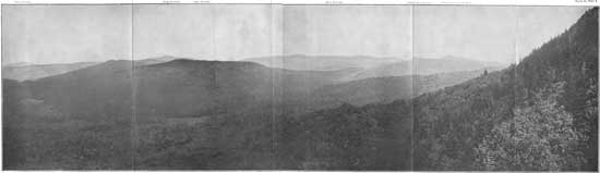
Extending out from the two great irregular mountain borders, the Blue Ridge and the Unakas, into the elevated region between them, and connecting them in places, are a series of more or less interrupted cross ridges, which have altitudes comparable to, and in one case (the Black Mountains) greater than, those of either the Blue Ridge or the Unakas. And these interior ridges are separated by high, but deep and generally narrow, irregular valleys. Standing on any of these elevated mountains, one may see stretching out in either of several directions an endless succession of mountain ridges and mountain peaks. A remarkable succession of these ridges and peaks is seen from the Grandfather Mountain, North Carolina, looking southwest, as shown in the accompanying panoramic view (Pl. VI). Hundreds of such vistas, from as many peaks, open out before the traveler through this region. In every direction the splendid hard-wood forests cover and protect the mountain slopes and the countless springs of water which flow from them as the sources of great rivers. There is but one discordant fact—the calamitous destruction of the forests on these mountain slopes. | ||||
| |||||
|
Variety of peaks and ridges. |
Some of these ridges, like the Black Mountains, are short, but high and massive and terminate abruptly. Others are longer and lower and slope gradually down to the adjacent valley or rise from a lower gap to another still higher ridge. All are more or less irregular both in their courses and their elevation. Most of them have peaks rising from their tops; but not a few have fairly uniform crests. (See Pl. XVII.) Some of these peaks, like the Grandfather (Pl. VII), are sharp, rugged, and rocky; others, like the Roan or the "Balds" (Pl. VIII a), are rounded domes whose tops are covered only with grass and rhododendron, while still others, equally tall and massive like the Blacks and the Great Smokies, are heavily forest covered to the summit. (See Pl. VIII b.) | ||||
| |||||
|
Magnitude of these mountains. |
The haziness of the atmosphere, which has found expression in the names "Blue Ridge" and "Smoky Mountain," often limits the distance of distinct vision, but it combines with the forest cover to soften the details and to render this Southern Appalachian landscape attractive beyond comparison. This succession of ridges and peaks, seen through it from an eminence, rising one above and beyond another for 50 or 100 miles or more, impresses upon the observer in a manner not to be forgotten the vastness of this region of mountains. It has 46 peaks, a mile or more apart, and 41 miles of dividing ridges, which rise above 6,000 feet; 288 additional peaks and 300 miles of divide rise more than 5,000 feet above the sea. These are not only the greatest masses of mountains east of the Rockies; they are the highest mountains covered with hard-wood forests in America. | ||||
|
Salient features. |
This region, thus unique in its position, in its mountain features, in its forests, and in its climate, stands grandly out as the greatest physiographic feature in the eastern half of the continent. (See Pls. II and VI.) | ||||
|
Mountain valleys. |
Between these groups of mountains and far below them, though still at an elevation of 2,000 feet or more above the sea, are the numerous narrow valleys of this region. They border the numberless streams and are generally more extensive nearer the sources of these streams, and hence nearer to the Blue Ridge than to the Unakas. (Pl. IX.) As a rule, they vary in width from a few hundred feet to as many yards. Some of the most notable of these valleys, reaching a width of 2 to 5 miles in places, are those on New River in Virginia, on the French Broad above Asheville, on the Tennessee River in southwestern North Carolina, and about the headwaters of the Coosa and other rivers in Georgia. As these streams approach and cut through the mountain borders of this region they run in deep gorges, the full width of which is often occupied by the streams. (See Pl. XXIX.) | ||||
| |||||
|
Steepness of the mountain slopes. |
The slopes of these mountains vary considerably in their steepness. The northwestern slopes of the Blue Ridge are usually gentle and in many places cleared. The southeastern slopes are generally much steeper and usually forest covered. In a few places these southeastern slopes are rocky and precipitous. Especially is this the case along the South Carolina border, as seen in Caesars Head, Whiteside, and Table Rock mountains (see Pls. X, XI, and XLV), where the bare rock walls rise 600 to 1,000 feet in height. The slopes of the Unakas, like those of many of the interior ridges, are fairly steep on both sides, ranging generally from 20 to 50 degrees. About the interior ridges there is still greater variation. Some of the rocky faces are precipitous, while elsewhere the slopes are gentle, ranging from 5 to 20 degrees. But taking the mountains and the valleys together, the land surface with a slope of less than 10 degrees is not more than 10 per cent of the whole. | ||||
| |||||


| <<< Previous | <<< Contents>>> | Next >>> |
sen_doc_84/report.htm
Last Updated: 07-Apr-2008