|
National Park Service
Confinement and Ethnicity An Overview of World War II Japanese American Relocation Sites |

|
Chapter 6
Heart Mountain Relocation Center
The Heart Mountain Relocation Center was located in Park County, in northwest Wyoming, 12 miles northwest of the town of Cody. Situated on terraces of the Shoshone River, the relocation center lies at 4700 ft elevation, within open sagebrush desert. Heart Mountain, a detached limestone fault block rising to 8123 ft elevation 8 miles to the west, forms a dramatic backdrop to the relocation center.
The relocation center reserve encompassed 46,000 acres (Figure 6.1). The adjacent Vocation railroad siding and existing Bureau of Reclamation irrigation developments likely influenced the location choice; construction was begun June 15, 1942, with a crew of 2,000 workers. The first evacuees, from California, Oregon, and Washington, arrived August 11, 1942, and the center was in operation until November 10, 1945. With a maximum population of 10,767, the center was the third largest city in Wyoming. Local residents recall that it was one of only a few communities in the state to have electricity.
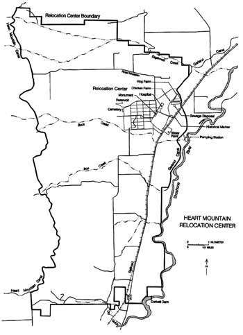 Figure 6.1. Heart Mountain Relocation Center. (click image for larger size) |
 Figure 6.2. Oblique aerial view of the Heart Mountain Relocation Center. (WRA photograph, National Archives) |
The Heart Mountain Relocation Center was a major part of the largest single draft resistence movement in U.S. history. To protest the unconstitutional confinement of their families, 315 Japanese Americans from all ten relocation centers were imprisoned for resisting induction into the military. Heart Mountain had the highest rate of resistance, with a total of 85 men imprisoned for draft law violations. The Heart Mountain total included seven leaders of the Heart Mountain Fair Play Committee who were convicted for conspiring to violate the Selective Service Act and for counseling other draft-age Nisei to resist military induction. In spite of substantial draft resistance at Heart Mountain, 700 men reported for their selective service physicals; of these, 385 were inducted, of whom eleven were killed and fifty-two wounded in battle.
The central area of the relocation center covered two terraces of the Shoshone River, which flows northeasterly along the eastern boundary of the reserve. The administration and residential areas were on the upper terrace (Figures 6.2 and 6.3). Support facilities and the hog and chicken farms were on the lower terrace. All were within the fenced area, guarded by nine watch towers. There was a sentry post at the main entrance and gate houses on the north, west, and south sides of the central area.
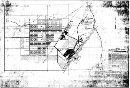 Figure 6.3. Heart Mountain Relocation Center. (National Archives) (click image for larger size (~150K) ) |
 Figure 6.4. Heart Mountain Hospital. (Hikaru Iwasaki photograph, Bancroft Library, University of California, Berkeley) |
The hospital complex, on the upper terrace at the far eastern edge of the central area, included 17 buildings with connecting covered walkways (Figure 6.4). Two of the buildings, a hostel and a garage, were former Civilian Conservation Corps (CCC) buildings. The administration and staff housing area, just southwest of the hospital complex, included eight office buildings, a fire station, a store, the post office, a garage, a storage building, 15 apartment and dormitory buildings, a recreation building, and a mess hall. Buildings of both the hospital complex and the administration area were laid out adjacent to Central Avenue, which ran southwest-northeast, roughly following the contour of the terrace.
The residential area, laid out on a north-south grid, was divided into 30 blocks, with 20 actually used for barracks. All but Block 7 were twice the size of blocks at the other relocation centers, with each block having 24 barracks, instead of the usual 12, and two mess halls, two recreation halls, and two toilet/laundry buildings. In all, there were 468 20-by-120-ft barracks. Blocks 5 and 20 were open areas, labeled "play areas" on WRA blueprints. Blocks 3, 4, 10, 11, 18, and 19, along the interior of the west side of the fenced area, also were never used for barracks. Victory gardens were located in blocks 10 and 11, and the center's cemetery was located west of block 19. A large pit was dug for use as swimming pool east of the residential area, on the lower terrace near a canal that ran through the center.
 Figure 6.5. Reassemblign a CCC building for use as a school. (Tom Parker photograph, Bancroft Library, University of California, Berkeley) |
A high school, completed by the evacuees May 27, 1943, was constructed in Blocks 13 and 16. It included a large building with several wings and three smaller buildings. At least one of the smaller buildings was moved to the relocation center from a nearby CCC camp (Figure 6.5).
On the lower terrace, next to the railroad, were the warehouse and motor pool area, with 60 buildings (Figure 6.6). Fifteen of the buildings were from a nearby CCC camp, and one was formerly a Works Progress Administration (WPA) building. Nearby to the northeast were three root cellars, a tool shed, and a relocated WPA shelter. The military police area was located at the entrance from State Highway 11 (now U.S. Highway Alt. 14). The WRA map indicates there were 19 buildings there, including a visitor building recycled from the CCC camp. Later, the military police contingent was reduced, and four buildings were relocated to the administration and staff housing area.
Also on the lower terrace, in the northeast portion of the camp, were the hog and chicken farms and the sewage disposal plant. At the hog farm, the WRA blueprint lists 13 hog sheds, loading chutes, and other facilities. At the chicken farm there were at least 23 chicken houses, a warehouse, a granary, a grain bin, some privies, and a lunch shelter. All of the sizable buildings were from a CCC camp. The sewage disposal plant included sludge beds, a pump house, a chlorination house, and a large buried "Imhoff" tank (Figure 6.7).
 Figure 6.6. Evacuees arriving through the warehouse area. (Tom Parker photograph, Bancroft Library, University of California, Berkeley) |
 Figure 6.7. Imhoff tank under construction at the sewage disposal plant; note size of structures in relation to workers. (WRA photograph, National Archives) |
 Figure 6.9. Farm field at Heart Mountain. (Hikaru Iwasaki photograph, Bancroft Library, University of California, Berkeley) |
Water for domestic use was pumped from the river (at the "low-level pumping plant") to a filter plant and pumping station (the "high-level pumping plant") across the highway from the warehouse area. Water was then pumped to a concrete reservoir on a low ridge northwest of the residential area.
Water for farming came from canals, most already in place from the Bureau of Reclamation's (BOR) Heart Mountain Reclamation Project. Evacuees, however, did construct 1 mile of canal, and used 850 tons of bentonite to waterproof some of the existing canal sections that leaked (Mackey 1998). A little over 1,000 acres were cleared for farming. Fields were located adjacent to the south and east of the central area, including across (east of) the highway. Other fields were located to the north and along both sides of the highway from the central area to 3-1/2 miles south (Figures 6.8 and 6.9).
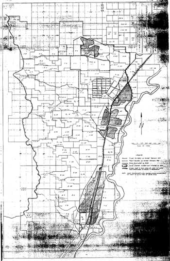 Figure 6.8. Farm fields at the Heart Mountain Relocation Center. (National Archives) (click image for larger size (~156K) ) |
 Figure 6.10. Transporting barracks from Heart Mountain. (Big Horn Basin Project Photography Collection, John Taggart Hinckley Library, Northwest College) |
After the relocation center was closed, buildings and equipment were auctioned off and farmers moved in to homestead the area (Figure 6.10). The farmers benefitted from the canal construction and repair and the land clearing accomplished by the evacuees. The BOR retained buildings in the hospital and staff housing area for offices, storage, and maintenance shops. Subsequently, the local Irrigation District used the buildings until 1980 (Larson et al. 1995).
There have been several recent studies of the relocation center, which provide information on the past history and current condition. In 1983 Michael Gorman of the Wyoming Recreation Commission reviewed the history of the camp and completed a National Register nomination for the hospital complex, which is located on BOR land. The parcel was listed on the National Register of Historic Places in 1985. In 1986 real estate appraiser George Page developed salvage estimates for two of the wood frame buildings in the staff housing area. His assessment provides information about construction details and the condition of the buildings at that time, which suffered from neglect and vandalism (Page 1986).
For a pipeline project, Welch et al. (1988) recorded features in the warehouse area, and noted extensive disturbance from fields and other agricultural activities. Additional features and artifacts of the hospital and administration complexes were recorded as part of a cultural resources inventory by Penny et al. (1990), who recommended that the National Register district be expanded to include the entire BOR parcel. Rose (1992) prepared a condition assessment of the four standing buildings for the BOR, and Larson et al. (1995) presented a paper at the Society for Historical Archaeology meetings which outlined the history of the center and its research potential.
Central (Fenced) Area
Most of the land at the Heart Mountain relocation center is currently under cultivation. However, three areas have intact features: the administration and hospital complexes, on Bureau of Reclamation land; the warehouse and root cellar areas on private land; and a portion of the high school, also on private land. Each area is discussed in more detail below. There are a total of six standing buildings, three at the hospital complex, one within the adjacent staff housing area, one small room or vault at the high school, and a root cellar in the warehouse area.
Hospital, Staff Housing, and Administration Areas
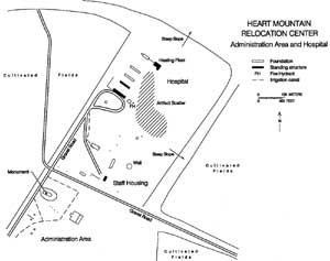 Figure 6.11. Hospital, staff housing, and administration areas. (adapted from Penny et al. 1990) (click image for larger size (~64K) ) |
The hospital and administration areas are located on public land administered by the BOR, which retains a 71-acre parcel. The three buildings still standing in the hospital area include the boiler house with its large smokestack, a warehouse, and a mess hall (Figure 6.11). All three buildings are abandoned, and windows and doors are broken or missing. All are of similar construction: foundations are poured concrete, walls and roofs are wood frame sheathed with boards and covered with asphalt shingles on the sides and rolled roofing on top.
The boiler house measures 50 by 90 foot in plan; the clay brick chimney tapers from a 8-1/2-feet-wide base and reaches over 75 feet in height (Figures 6.12 and 6.13). The warehouse (called a personnel housing unit in Penny et al. 1990 and Rose 1992) is 24 by 120 foot in plan (Figure 6.14); the mess hall (called a ward in Penny et al. 1990) is 40 by 180 ft (Figure 6.15). Designations used in this report are based on those listed on the WRA blueprints. For more detailed descriptions the reader is referred to Rose (1992).
 Figure 6.12. Hospital boiler house at Heart Mountain. |
In addition to the buildings there are numerous other features present, including power poles, a loading dock, a fire hydrant, a manhole, and two 20-by-120-foot concrete slabs (Figures 6.16 and 6.17). The WRA blueprint suggests the slabs, north of the standing warehouse, are foundations of an additional warehouse and the morgue. A smaller slab north of the morgue slab is 36 feet by 87 feet; this foundation, connected to the boiler house with a concrete sidewalk, is in the location of the hospital laundry on the WRA blueprints (Figure 6.18). It appears to have been converted to a service station after the relocation center use, and there is a concrete gasoline pump island adjacent (Figure 6.19). East of the hospital along the edge of the terrace there is some relocation center building debris, as well as several post-relocation-center trash dumps.
The staff housing area adjacent to the hospital complex still has one of its original buildings, used by the Heart Mountain Extension Club from 1953 to 1985. The building, 24 feet by 50 feet, is actually only half a building (Page 1986). Walls are wood frame with cement/ asbestos fiber shingles, the roof has asphalt shingles (Figure 6.20). Other features present in the staff housing area include two concrete slab foundations, one 26 by 80 feet and one 26 by 125 feet, a 7-foot-square concrete cellar (Figure 6.21), and possible concrete perimeter foundation remnants of two other buildings. There are four manholes in place, two power poles still standing, and a sign post that may have been a street sign during the relocation center use. A stone and concrete barbeque in the area was probably constructed and used by the Main family, according to Larson et al. (1995:6); noted inscribed in the mortar were the names "Becky," "Pop," "CEI," "Momy," "MARG," "Sally 1944," "LAW 50," and "1944" (Penny et al. 1990).
There is a memorial at the former administration area where the Honor Roll was constructed in front of Administration Building No. 1 (as listed on WRA blueprints) during the relocation center occupation. The Honor Roll consists of a large wooden sign within a raised rock and concrete planter and an original flag pole (Figure 6.22). No text remains on the Honor Roll, but the sign once included the names of Japanese American servicemen from Heart Mountain.
South and east of the Honor Roll there are concrete slabs, footings, building debris, a manhole, and other traces of former buildings. Slabs include two measuring 14 feet by 14 feet, two measuring 14 feet by 21 feet, and one 125 feet by 125 feet in size. The larger slab was the foundation of Administration Building No. 5, according to the WRA blueprints; the smaller ones do not conform to buildings on the blueprints, but may have been patios for staff apartments.
 Figure 6.13. Interior of hospital boiler house. |
 Figure 6.14. Hospital warehouse at Heart Mountain. |
 Figure 6.15. Hospital mess hall at Heart Mountain. |
 Figure 6.17. Concrete slab in hospital area. |
 Figure 6.18. Concrete slab of hospital laundry building. |
 Figure 6.20. Building in staff housing area. |
 Figure 6.16. Fire hydrant in hospital area. |
 Figure 6.19. Gas pump island in hospital area. |
 Figure 6.21. Basement in staff housing area. |
 Figure 6.22. Honor Roll in administration area. |
Central (Fenced) Area
Warehouse Area
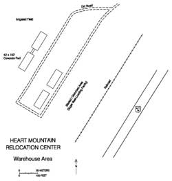
In the warehouse area there are four 40 by 100 foot slabs, two connected with a 9-foot-ramp (Figure 6.23; Welch et al. 1988). One of the slabs has a mobile home on it. A dilapidated root cellar northeast of the warehouse area is still present (Figures 6.24 and 6.25). Construction of the root cellar, however, may pre-date the relocation center (John Collins, local resident, personal communication, 1994).
Central (Fenced) Area
Other Areas
 Figure 6.26. Residential area, Heart Mountain Relocation Center. (Tom Parker photograph, Bancroft Library, University of California, Berkeley) |
Cultivated fields now cover all of the former evacuee barracks area (Figures 6.26 and 6.27). However, a portion of the former high school location has been left uncultivated. Within this area there is small concrete building that might have been a vault (Figure 6.28). The cemetery location is also now farm land. The burials were removed when the center was closed; seven were re-buried in the cemetery at Powell, Wyoming (Inouye 1997).
On the lower terrace the locations of the hog farm, sewage treatment plant, and military police compound are now fields. The sewage disposal plant, a massive underground tank, likely remains buried. The swimming pool, which was likely never lined with concrete, is still evident as a depression, though silted in and overgrown with vegetation (Figure 6.29 and 6.30).
 Figure 6.27. Residential area today, Heart Mountain. |
 Figure 6.28. Concrete structure at the location of the Heart Mountain Relocation Center high school. |
 Figure 6.29. Swimming pool at Heart Mountain today. |
 Figure 6.30. Remains of swimmign pool diving board. |
Security Features
 Figure 6.31. Remnants of the perimeter security fence southeast of the warehouse area. |
No guard tower remains were relocated, probably because of the extensive disturbance caused by agriculture. However, in the warehouse area there are portions of the original perimeter fence (Figure 6.31). These remnants are of more substantial construction then those evident in any other relocation center except Tule Lake, and contrast with the typical 5-strand barbed wire depicted in early fence photographs. The warehouse fence may have been upgraded sometime during the relocation center occupation: the hospital and administration areas were the scene of some of the work stoppages and protests revolving around unfair working conditions and discrimination (Larson et al. 1995:6), and the warehouse area may have been seen as a potential target of protest activity.
Outlying Features
The relocation center landfill could not be relocated even after searching the area depicted on WRA blueprints. Since this area is now farm fields the dump may be buried, or it may have been located elsewhere. There is a large dump just west of the relocation center site, but it appears to contain only post-relocation center material.
Foundations of the "low-level pumping plant" which pumped water to the filter plant remain on the bank of the Shoshone River. A 20-foot-by-45-foot foundation is located in an area overgrown with vegetation (Figure 6.32). The area just east of the highway from the relocation center where the water plant and "high-level pumping plant" were located is now two separate farms. It is not known if any buildings or foundations from the relocation center use remain.
The concrete water reservoir is still on the ridge northwest of the evacuee barracks area. About 120 feet by 150 feet in size, it apparently originally had a wood and shingle roof (Figure 6.33). There is a small trash dump nearby consisting mostly of cans. The dump probably post-dates the relocation center use, since cans were generally recycled during the war. The dump contains a 1959 Wyoming automobile licence plate, also suggesting later deposition.All of the canals and fields used by the relocation center are still being used. Rock and concrete work along the Heart Mountain Canal, noted on WRA blueprints as done by the evacuees, is still evident in numerous spots, especially at bridges and head gates.
 Figure 6.32. Remains of the low-level pumping plant. |
 Figure 6.33. Concrete reservoir at Heart Mountain. |
Interpretation
In 1995 the Buffalo Bill Historical Center in the town of Cody had a temporary exhibit on the Heart Mountain Relocation Center. Located in a well-traveled area of the museum, the display included text, photographs, examples of the relocation center newspaper, the mimeograph machine that printed the newspaper, a Wyoming state flag used by the relocation center Girl Scout troop, a child's diary, and other artifacts.
 Figure 6.35. Detail of marker placed by the American Legion. |
Fifteen miles north of Cody along U.S. Highway Alt. 14, there is a historical monument placed by the American Legion and a directional sign to the relocation center memorial park. The American Legion marker, erected in 1963, mentions the state-of-the-art sewage system, excellent schools, and other amenities that were available to the evacuees (Figures 6.34 and 6.35).
The original Honor Roll, which was inscribed with the names of soldiers from the relocation center, is the central piece of the Heart Mountain Memorial Park (Figures 6.36-6.40). The park was initiated by the Heart Mountain Relocation Center Memorial Association, formed by homesteaders after World War II. The park includes plaques, a sidewalk, and a graveled parking area surrounded by large rocks. Also there is a concrete slab that once supported a brick chimney with a plaque noting it was moved from Block 23. To the north are the three standing hospital buildings and the staff residence. The Heart
Mountain Memorial Foundation has proposed to restore the buildings and use one for an interpretive center.
There are several fine examples of former barracks in the surrounding area. One was donated to the Japanese American National Museum in Los Angeles (Figure 6.41). It was dismantled, trucked, and reassembled there. Another good example of a recycled barracks is on a farm just north of Cody on State Highway 120. It appears to be unused at present (Figure 6.42).
 Figure 6.41. Barracks building later moved to the Japanese American National Museum in Los Angeles. |
 Figure 6.42. Recycled barracks along State Highway 120 north of Cody, Wyoming. |
Also at the Japanese American National Museum in Los Angeles is a 55-gallon barrel full of small stones, each one carefully inscribed with a Japanese character. The barrel had been uncovered near the former relocation center cemetery by local landowners Les and Nora Bovee, who donated them to the museum in 1994. It has been theorized that the stones may have been Buddhist sutras to memorialize the dead, but the museum is still seeking more information about them (JANM Quarterly Summer 1994).
The burials at the relocation center cemetery were moved to the Crown Hill Cemetery in the town of Powell, 11 miles northeast of Heart Mountain. The cemetery is located on the eastern edge of Powell on the south side of Lane 7 (Cemetery Road). Section 13 of the cemetery contains five headstones with Japanese surnames. Three of the headstones are large river-worn cobbles set in concrete (Figure 6.43). The inscriptions on one face of each cobble are English and those on the other face are Japanese. The inscribed dates indicate these people died in November and December 1942 (Figures 6.44-6.46). The other two headstones noted at the cemetery are typical western designs and include 1945 and 1946 dates (Figures 6.47 and 6.48).
 Figure 6.34. Historical marker placed along U.S. Highway Alt. 14 by the American Legion. |
 Figure 6.36. Detail of historical marker at memorial park. |
 Figure 6.37. Detail of historical marker at memorial park. |
 Figure 6.38. Detail of historical marker at memorial park. |
 Figure 6.39. Detail of historical marker at memorial park. |
 Figure 6.40. Heart Mountain Memorial Park. |
 Figure 6.43. Crown Hill Cemetery, Powell, Wyoming. |
 Figure 6.44. Headstone at Crown Hill Cemetery. |
 Figure 6.45. Headstone at Crown Hill Cemetery. |
 Figure 6.46. Headstone at Crown Hill Cemetery. |
 Figure 6.47. Headstone at Crown Hill Cemetery. |
 Figure 6.48. Headstone at Crown Hill Cemetery. |
| <<< Previous | <<< Contents>>> | Next >>> |
wacc/74/chap6.htm
Last Updated: 20-Feb-2004
