|
National Park Service
Confinement and Ethnicity An Overview of World War II Japanese American Relocation Sites |

|
Chapter 7
Jerome Relocation Center
The Jerome Relocation Center was located in Chicot and Drew Counties, Arkansas, 18 miles south of McGehee and 120 miles southeast of Little Rock. It was one of two relocation centers in Arkansas — 27 miles north was the Rohwer Relocation Center. The relocation center was named after the town of Jerome, which was located one-half mile south. However, the official post office designation for the center was Denson.
The relocation center site is located in the Mississippi River delta region about 12 miles west of the river. At an elevation of 130 feet, the area is laced with cut-off meanders and bayous. Big and Crooked Bayous flow from north to south in the central and eastern part of the former relocation center reserve. Today the forests that once covered the area are now mostly gone, replaced by rice and soybean fields and fish farms.
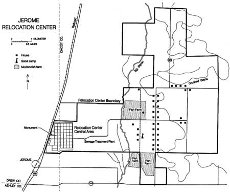
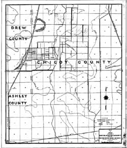
The relocation center reserve encompassed 10,000 acres of tax-delinquent lands purchased through a trust agreement in the late 1930s by the Farm Security Administration (Figure 7.1). Plans had been to develop the lands by clearing trees and draining swampy areas so that they could provide subsistence for low-income farm families (Bearden 1989).
The roughly 500-acre central area of the relocation center was on the western edge of the reserve along U.S. Highway 165. Construction by A.J. Rife Construction Company of Dallas, Texas, began July 15, 1942, and the center was ready for use on October 6, 1942. The maximum population, reached in November 1942, was 8,497. Internees were from California and Hawaii. Jerome was the last of the relocation centers to open and, in June 1944, the first to close.
 Figure 7.1. Jerome Relocation Center. (click image for larger size) |
The closure of the Jerome Relocation Center was cited as a sign of the WRA's success in placing Japanese Americans in jobs and homes outside of the West Coast restricted zone. The overall population of the ten relocation centers declined in 1944 as over 18,000 evacuees moved out through the WRA leave process. Jerome was chosen for closure for three reasons: it was the least developed of the relocation centers, it had one of the smallest populations, and the nearby Rohwer Relocation Center could absorb most of the Jerome residents reducing the amount of transportation needed.
While across the country there were several instances of military police shooting relocation center residents, Jerome was the site of the only known shooting of evacuees by local civilians. A tenant farmer on horseback on his way home from deer hunting came across three Japanese Americans on a work detail in the woods. Thinking the Japanese Americans were trying to escape, he fired one round of buckshot, wounding two of them. Referring to the fact that a Caucasian engineer supervisor was present, the farmer explained he thought the supervisor was trying to aid the escape (Denison Tribune Communiqué 11/17/42).
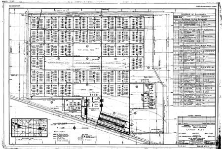
The relocation center was divided into 50 blocks surrounded by a barbed wire fence (Figures 7.2 and 7.3), a patrol road, and seven watch towers (Figure 7.4). The only entrances were from the main highway on the west and on the backside (east) of the central area. Only the residential blocks were consistent in size, but all of the blocks were on a north-south grid, except for the warehouse block which was aligned with the adjacent Missouri Pacific railroad.
 Figure 7.2. Jerome Relocation Center. (click image for larger size (~168K) ) |
  Figure 7.3. Panorama view of the Jerome Relocation Center from the southwest. (Hikaru Iwasaki photograph, Bancroft Library, University of California, Berkeley) (click image for larger size (~115K) ) |
There were over 610 buildings at the center. The military police compound (designated Block 26), located north of the main entrance, included 12 buildings (Figure 7.5). The administration area (Blocks 24, 25 and 37) had 18 buildings; four of these, listed on the WRA blueprints as "relocated houses," were likely used for staff housing. The warehouse area (Block 37) had 21 buildings, and the hospital (Blocks 47 and 49) had 16 buildings. Block 50, east of the hospital, had four "relocated barns." Block 48, south of the warehouses, was used for coal storage.
 Figure 7.4. Jerome watch tower. (Charles E. Mace photograph, Bancroft Library, University of California, Berkeley) |
 Figure 7.5. Military police compound at Jerome. (Charles E. Mace photograph, Bancroft Library, University of California, Berkeley) |
 Figure 7.8. Young children at Jerome. (Gretchen Van Tassel photograph, Bancroft Library, University of California, Berkeley |
The 36 residential blocks were located east of the military police and administration areas (Figures 7.6-7.8). They lay within a rectangle six blocks east-west by eight blocks north-south. The easternmost row was noted as "wooded." Each residential block had twelve 20 foot by 120 foot barracks, a recreation building, a mess hall, and a combined bathroom and laundry building. Well houses were located in Blocks 23 and 39.
Three blocks (10, 21, 22, and 34) were set aside for a high school and elementary schools. However, it appears that no school buildings were ever built in these areas. Instead, one of more residential bocks were likely used for schools. The caption of a June 1944 photograph of a general-purpose auditorium indicates it was only recently completed (Figure 7.9). On WRA blueprints Block 22 is labeled as the "church and store area," but the buildings listed there include only a fire house, a pumping station, and a water storage tank.
The sewage treatment plant was located about one-half mile east of the residential area. A 1943 WRA blueprint shows a cemetery just inside the perimeter fence in the southwest corner of the relocation center, but reportedly the cemetery was never used.
Outside the fenced central area the evacuees cleared land for farming, dug ditches, and built bridges (Figures 7.10 and 7.11). Many of the trees cleared were put to use: between July 1943 and February 1944, Jerome produced over 280,000 board feet of lumber and over 6,000 cords of firewood (Figure 7.12).
 Figure 7.10. Evacuee-constructed ditches at the Jerome Relocation Center. (click image for larger size) |
The Jerome and Rohwer relocation centers grew 85 percent of their own vegetables (Figure 7.13; Bearden 1989). In 1943, 630 acres were put under cultivation at Jerome. In 1944, 718 acres were under cultivation, 200 additional acres were cleared but not farmed, and several hundred more acres were partially cleared (Denson Tribune Communiqué 2/22/44).
Over 1,200 hogs were raised by the evacuees for consumption at the center. The hog farm location is not known, but it likely utilized an existing farm within the relocation center reserve. A map in the Denson Tribune Communiqué (3/9/43) shows 37 houses within the reserve, most east of Big Bayou along a north-south road(now State Highway 293).
Four miles east of the residential area the evacuees built a 45-acre scout campsite. Three five-room buildings near the camp site were used as a scout headquarters and field houses.
After the relocation center was closed in 1944 it was converted into a Prisoner of War camp for Germans, although the POWs were confined to the central area and did not work the surrounding fields. All of Block 1 was occupied by a German general captured at the Battle of the Bulge and his orderlies. Another block was isolated from the rest of the camp to house SS troops. Two German POWs who escaped later turned themselves in (John Ellington, personal communication, 1994).
 Figure 7.6. Typical Jerome street scene. (Hiksru Iwasaki photograph, Bancroft Library, University of California, Berkeley) |
 Figure 7.7. Barracks, Block 44, Jerome Relocation Center. (Charles E. Mace photograph, Bancroft Library, University of California, Berkeley) |
 Figure 7.9. Multi-purpose auditorium at Jerome. (Hiksru Iwasaki photograph, Bancroft Library, University of California, Berkeley) |
 Figure 7.11. Drainage Ditch No. 1 at Jerome (Charles R. Lynn photograph, Bancroft Library, University of California, Berkeley) |
 Figure 7.12. Sawmill at Jerome Relocation Center. (Tom Parker photograph, Bancroft Library, University of California, Berkeley) | |
 Figure 7.13. Cabbage harvest at Jerome. (Gretchen Van Tassel photograph, Bancroft Library, University of California, Berkeley) | |
Central Area
Currently the former administration and barracks area is delimited by U.S. Highway 165 on the west and rows of windbreak trees on the north and south. The central portion is owned by John Ellington; the area that once housed over 8,000 people is now occupied and farmed by one extended family. John Ellington lived on a farm east of the relocation center in the 1940s and has lived in the vicinity since 1932. He met numerous Japanese Americans when they were working on surrounding farms and also when he visited the center.
There are currently several residences and farm buildings in the central area (Figure 7.14). Remains from the relocation center include a large brick smokestack, a concrete water reservoir, two "relocated houses," and several concrete slab foundations. Only an occasional artifact possibly associated with the relocation center was seen in the central area. These include fragments of clear and amber glass, hotel ware ceramics, concrete, and bricks.
 Figure 7.14. Site of the Jerome Relocation Center today. |
 Figure 7.15. "Relocated House" at Jerome today. |
 Figure 7.16. Fire hydrant at Jerome. |
The relocated houses (Figure 7.15) were originally built by the Farm Security Administration and moved to the relocation center by the WRA (John Ellington, personal communication, 1994). Near one there is a fire hydrant with a 1942 date (Figure 7.16).
The most salient feature remaining at the site is the 100-foot-tall yellow brick hospital boiler house smokestack (Figures 7.17 and 7.18). The smokestack is in poor condition; a portion of the top has already fallen.
The massive concrete reservoir, located in what once was the central area, now stands unused amongst the farm fields (Figures 7.19 and 7.20). Nearby, concrete pads and machinery from the two deep wells that supplied the relocation center also remain (Figure 7.21). According to John Ellington's son, a previous owner had cleared the immediate area, dug ditches, and reused the deep water wells in an attempt to grow rice.
Several of the concrete slabs for buildings in the administration area are still in existence and serve as foundations for farm buildings. Seven concrete slabs and asphalt paving in the warehouse area are used as foundations for grain silos and to store farm equipment (Figure 7.22).
Most of the residential area has been cleared and leveled and is under cultivation for rice and soybeans (Figure 7.23). But some of the raised gravel roads are still used (Figure 7.24). There are no variations in soil or vegetative growth to indicate the original slab or pier foundations in the fields, and it is not known if they lie buried or were removed. Within the central area a low-lying flooded area (possibly a recent borrow pit) had abundant concrete debris, likely from relocation center building foundations, along its banks.
 Figure 7.17. Hospital boiler house and smokestack. (Tom Parker photograph, Bancroft Library, University of California, Berkeley) |
 Figure 7.18. Smokestack at Jerome today. |
 Figure 7.19. Water reservoir under construction. (Tom Parker photograph, Bancroft Library, University of California, Berkeley) |
 Figure 7.20. Water reservoir at Jerome today. |
 Figure 7.21. Deep water well at Jerome today. |
 Figure 7.22. Warehouse area at Jerome today |
 Figure 7.23. Residential area at Jerome today. |
 Figure 7.24. Relocation center road today. |
Security Features
Along the southern perimeter of the former residential area there are a few concrete fragments and foundation blocks from a watch tower, obviously displaced (Figure 7.25). The perimeter fence is gone and no other watch tower foundations were seen.
 Figure 7.25. Watch tower foundation blocks. |
Outlying Areas
 Figure 7.28. Equipment at the Jerome sewage treatment plant today. |
One-half mile east of the relocation center residential area is the sewage treatment plant. It is in good condition and much of its associated machinery, such as pumps and other equipment, still remain. One interesting feature of the plant was the innovative use of filter rock, much of which is still present (Figures 7.26-7.28).
No other outlying features definitely associated with the relocation center were identified. West of the relocation center and U.S. Highway 165 are the Jerome railroad siding and the old highway (Figure 7.29). When the relocation center was in use, the highway was on the west side of the railroad. The present highway, east of the railroad, was constructed through the western edge of the central area, where H Street, the boundary fence, and the west patrol road were once located.
Most of the surrounding countryside, including the scout camp, is now irrigated fields or fish farms. Little remains of the forest that covered most of the area in the 1940s. Currently-used ditches follow the 1940s alignments. All are unlined, and have steel pipe control gates and valves (Figure 7.30).
 Figure 7.26. Sewage treatment plant under construction. (Tom Parker photograph, Bancroft Library, University of California, Berkeley) |
 Figure 7.27. Sewage treatment plant at Jerome today. |
 Figure 7.29. Old highway west of Jerome. |
 Figure 7.30. Typical ditch at Jerome. |
Interpretation
 Figure 7.31. Historical monument at Jerome. |
The relocation center site is commemorated by a 10-foot-tall granite boulder monument along the east side of U.S. Highway 165 (Figure 7.31). In 1992, John Ellington gave his permission for construction of the monument and also indicated that he would not remove the hospital boiler house smokestack, now a local landmark. However, the smokestack is in need of stabilization, since it has begun to deteriorate. Although the relocated center site is on private land, the Ellingtons have allowed visitors to see the remaining features, and are a wealth of information.

| <<< Previous | <<< Contents>>> | Next >>> |
wacc/74/chap7.htm
Last Updated: 20-Feb-2004