|
GEOLOGY, AIR & CLIMATE
Rapid and Gradual Change In The Pacific
Northwest
Volcanic eruptions, landslides, floods
and earthquakes remind us that this landscape is dynamic and
ever-changing. These dramatic events can change habitat and ecosystems
instantly.
Landslides triggered by heavy rains or earthquakes deliver
sediment and large wood to streams. Landslides can also block valleys
and form new lakes. The Cascade volcanoes Mt. Baker, Mt. Rainier, Mt. St. Helens and
Glacier Peak are active, and geologically speaking, very young features.
Glacier Peak and Mt. Baker had significant cone-building eruptions
12,000 years ago. Colossal ice sheets covered all but the highest peaks in the
North Cascades as recently as 16,000 years ago, and blocked
north-draining valleys at Olympic NP.
More gradual changes occur over decades or centuries. Changes in air
quality, growing season, temperature, precipitation and solar radiation
can also be influential in altering ecosystems. Pollution is carried by prevailing winds into the Olympics and
Cascades from Puget Sound and Asia. Winter storms and cold temperatures
in the mountains scrub some of this pollution from the air and deposit
it in lakes, streams and glaciers. Changes in air and water temperatures are lengthening the growing
season, melting glaciers, and shrinking the subalpine and alpine
zones.
Critical knowledge of these rapid and slow
processes is needed to manage the parks and understand results from
plant and animal monitoring programs. Our ability to protect and
preserve ecosystems hinges on an understanding of soils, air quality,
geologic processes, climate change floodplains and other abiotic
factors. The program we are developing consists of three
levels:
Inventories of important resources including soils, landslides,
and glaciers. Monitoring of key variables such as air and water quality,
glaciers, climate, and streamflow. Research linking inventory and monitoring observations with
events and processes that are constantly changing.
NPS Nature—Net:
www2.nature.nps.gov/geology
NPS Views of Parks Publications—
www2.nature.nps.gov/synthesis/views/System/Help/Help_Pubs.htm
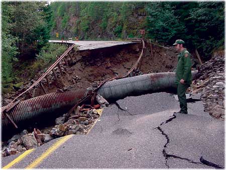

NPS Ranger Charles Beall surveys
flood damage to State Route 20 at Pyramid Creek. Heavy rainfall in
October 2003 led to historic floods that caused widespread damage to
roadways, hiking trails and campgrounds.
|
Soils
Soil is is the foundation for life;
key to nutrient cycling, the hydrological cycle and energy capture and
transfer.
Inventory:
Develop digital data on soils types, characteristics and
distribution. Relate soils types to landforms, habitat, organisms, and other
ecological conditions. Ebey's Landing and San Juan NHP have been mapped
in the past two years, while the focus shifts to North Cascades in
2005.
Monitoring:
Erosion of soils on Ross Lake. Human impacts in wilderness areas.
Research:
Assess methods for mapping soils in rugged, remote parks. This
effort is being led by the Natural Resources Conservation Service and
Washington State University faculty. A pilot project was completed for
Thunder Creek Watershed at North Cascades in 2004. Determine which soils types and organisms in soil are most
vulnerable to climate change. uantify the level of pollutants, such as mercury, pesticides and
herbicides in soils, and their impact on soils chemistry, processes and
organisms.
Air Quality
North Cascades NP has some of the
clearest air in the lower 48 states, ranking ahead of many other
national parks in the west. Air quality is monitored at two locations
and there is a web cam located at the North Cascades Visitor Center with
views of the southern Pickets.
Monitoring:
At Marblemount, acid deposition and ozone are monitored. At Ross Dam, visibility, nitrogen and sulphur aerosols are
monitored. Ozone concentration at low elevations is rising at North Cascades
NP, while trends for sulphur and nitrogen are less clear. Rainfall is slightly acidic, which is a concern in high lakes
ecosystems.
Research:
Three research projects are assessing impacts
of air quality on park resources. The first study is examining lakes and
fish tissue for the presence of mercury and pesticides. These pollutants
are found in most alpine ecosystems in western North America - initial
results indicate that some lakes in the North Cascades have elevated
levels of mercury. Two linked studies are looking at sulphur and
nitrogen deposition in snowpack and stream water.
Climate Change
The Pacific Northwest region is
sensitive to global climate changes because of its latitude, proximity
to the Pacific, and mountainous topography. Research about past climate
fluctuations can help determine the magnitude and pace of future climate
changes that may occur as a result of global warming. We have learned
that during El Niño years, this region's weather is dry and
glaciers shrink. Also, the regional climate cycles between dry/warm and
wet/cool over 10-15 year periods.
Monitoring:
Weather conditions at North Cascades are
monitored at 13 sites by the NPS and hydroelectric utilities through
cooperative agreements with the Natural Resources Conservation Service.
In 2003, a weather station was installed in Marblemount that is part of
the national long-term Climate Reference Network of stations designed
to observe climate change across the country. Variables that are
monitored include precipitation, snow depth, snow water content,
temperature, relative humidity and wind speed and direction. Glaciers
are excellent indicators of climate change, and evidence indicates that
glaciers' area has decreased more than 30% at North Cascades in the last
150 years due to longer, warmer summers and drier winters.
Research:
Several research projects are assessing the impact of global
climate change on park ecosystems. A recently completed study assessed
the impact of shrinking glaciers on summer streamflow and determined
that if present trends continue, summer streamflow in Thunder Creek
watershed will be significantly reduced by 2005. An ongoing research project headed by the US Forest Service and
US Geological Survey is examining impacts of climate change on broad,
landscape-level ecosystem changes. Research is being conducted in the North Cascades into glacier,
climate and environmental changes spanning the last 30,000 years. This
project is studying the massive Cordilleran Ice Sheet and fluctuations
of alpine glaciers during rapid climate change at the end of the last
great ice age.
NPS Nature and Science:
www2.nature.nps.gov/air/features/climatechangeparks.htm
NASA Global Change Master Directory:
gcmd.gsfc.nasa.gov/Resources/pointers/glob_warm.html
Mass Wasting
Landslides are common on steep slopes
in mountainous areas and along coastlines. These avalanches can be very
large and have pronounced effects on natural resources. For example, a
landslide dam created Lake Crescent at Olympic National Park (NP). As
recently as the fall of 2003 a lake was created along Goodell Creek in
North Cascades NP. NPS surficial geology mapping is producing
inventories of all landslides to:
Determine the causes, ages and ecological implications of large
landslides. Are large landslides triggered by earthquakes, and if so,
which kind? Determine what ponds, lakes and wetlands in the three parks were
created by landslides and when. Evaluate and monitor the effects of ground water on different
types of landslides.
Hydrology and Glaciers
Hydrologic systems in the three
mountain parks are complex and may include glaciers, hot springs,
extensive surface water resources and extensive aquifers on the floors
of large valleys. These landscapes collect snowfall in winter and
release it to lowland areas in spring, while vast glaciers trap water as
frozen reservoirs and release water more slowly, buffering aquatic
ecosystems from summer and longer droughts. Most of the major rivers are
prone to frequent large floods due to steep slopes, heavy precipitation
and rapid snowmelt events. The US Geological Survey monitors streamflow
and lake surface elevation on large reservoirs and rivers.
Volcanic Eruptions
Cascade volcanoes have shaped the
ecosystems of the entire Pacific Northwest. Research is needed to
improve our understanding of the chronology, magnitude and effects of
the eruptions. Mt. Rainier was named a United Nations Decade Volcano
Demonstration Project in the early 1990s.
Research:
Determine the distribution and thickness of volcanic ash
deposits. To date, 21 separate volcanic ash deposits have been
identified on Mt. Rainier, while 4 distinct layers of volcanic material
have been identified in the North Cascades. How have past volcanic eruptions affected soil formation, water
quality, air quality, geologic processes and ecosystems?
|


