|
Big Bend National Park Texas |
|
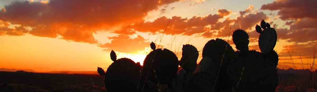 NPS photo | |
In Big Bend National Park roads end at the Rio Grande, the boundary between the United States and Mexico. But far more than two nations meet here. Three states abut at the river: Texas in the United States and Coahuila and Chihuahua in Mexico. Many of the park's famous, expansive vistas mix scenes belonging to both nations, One of the park's best-known features, Santa Elena Canyon, is only half a canyon on the United States side. Its south canyon wall towers above Mexico. Big Bend National Park also marks the northernmost range of many plants and animals, like the Mexican long-nosed bat. The ranges of typically eastern and typically western species meet or overlap here. Many species here are at the extreme limits of their ranges. Latin American species, many from the tropics, range this far north, while northern—nesting species often travel this far south in winter. Its location on a bird migration route between South, Central, and North America makes the park excellent for birding. The Rio Grande corridor is also a migration highway for many species—passing through the desert. Elevation contrasts create varied microclimates that further enhance the diversity of plant and animal life and the park's wealth of natural boundaries. Birders and other wildlife watchers know that the greatest numbers of species often are found at the ecotone (the transition area) between adjacent ecological habitats. The park's many, varied ecotones—formed by river, desert, and mountains—result in an outstanding diversity of wildlife.
The River
Big Bend refers to the great southwest Texas U-turn the Rio Grande makes here—defining the park boundary for 118 miles. The river is an arcing linear oasis, a ribbon of green that cuts across the dry desert and carves deep canyons. Like all rivers surviving desert passages, it has its headwaters outside this desert, in Colorado. Irrigation, dams, agriculture, manufacturing, exotic plants, and evaporation sap most of the Rio Grande's water before it gets to the park. Inside the park the river's water mostly comes from Mexico's Rio Conchos.
Jackrabbit
Big ears are the jackrabbit's distant early warning system against its predators. The ears also work as radiators to transfer excess body heat to the environment as needed.
Garfish and some turtles, living fossils, hint at the lush savannah and swamp of 50 million years ago. Their ancestors swam with crocodiles and hippopotamus-like creatures. If you wonder at the river's power—did it truly cut colossal canyons?—just listen to a canoe's hull hiss from the river's abrasive particles. The river has run for eons like a belt sander.
The river creates a riparian corridor for species not adapted to arid desert life, adding to the park's biological diversity. Its thin floodplain looks like a green belt in the desert. Beaver tooth marks on riverside cottonwood or willow trees may startle you, but beavers live in bank burrows here. Some birders say birds in the floodplain are more colorful than elsewhere. Summer tanagers, painted buntings, vermilion flycatchers, and cardinals accent green foliage. River sand and gravel bars and cliff banks host creatures not expected in the Chihuahuan Desert. Sandpipers and killdeer sprint on sandbars. Cliff swallows fly to adobe nests of river mud.
Kangaroo Rat
The kangaroo rat is superbly adapted to dry desert life. It does not need to drink to survive. It can metabolize water from carbohydrates in seeds, and it wastes no excess moisture.
The Rio Grande floodplain has been home to people for many centuries, well before Spaniards arrived here seeking gold, silver, and fertile land in the 1700s and 1800s. In 1773 they established Presidio del Paso de San Vicente at a major river crossing. Comanche raiding parties routinely crossed to and from Mexico during the 1800s. In 1852 US Army Maj. William H. Emory did a boundary survey and his party floated Mariscal Canyon. An 1881 Texas Ranger-led survey party floated Santa Elena Canyon. An 1899 US Geological Survey party was the first group known to run Boquillas Canyon. Anglo-American settlers began farming the river's banks after 1884, and Mexicans before 1900. Cotton and food crops were grown around Castolon and today's Rio Grande Village even after the park was created.
The Desert
Big Bend National Park lies in the northern part of the Chihuahuan Desert, one of North America's four major deserts. Rain-blocking mountains border the Chihuahuan on three sides. Its other side abuts vast semiarid plains.
This young desert is just 8,000 years old. Green and fairly lush, its rainfall comes mostly in the July-to-October monsoon. Its rains and clouds can mean far cooler summer days than you might expect in a desert. Heat and seasonal winds increase aridity. Summer ground temperatures may be 140°F at midday—or freezing in winter as northern storms sweep by. If you want warmer winter walking or hiking or just to enjoy the outdoors, the good news is that the lower desert can be near 80°F in winter.
Roadrunner
Running at speeds up to 20 mph, the roadrunner pursues lizards and small rattlesnakes. It pecks them to death with stunning blows of its beak. The roadrunner gets much of its required moisture from the body fluids of its prey.
Desert life is adapted to save its energy and to get and keep water. Many animals beat the heat by being out only at night. Most snakes do this—hot summer days on the desert floor would kill them in minutes. Another way to beat this heat is to climb above it. Summer travelers cross the desert quickly, headed for the higher, cooler Chisos Mountains. Some insects fly straight up a short distance to cool off. One walking beetle seems to rise up on stilts to escape killing heat.
Ancient peoples lived here some 10,000 years ago but left little evidence until the Archaic or Desert Culture 8,000 years ago. They used hundreds of desert plants as food and medicine, including sotol, lechuguilla, yucca, prickly pear, mesquite, and acacia. They wove baskets and sandals of lechuguilla fiber and yucca leaves and hunted deer, rabbits, and other animals with atlatl throwing sticks and stone-tipped darts. Desert springs gave them drinking water. Home sites often still have remnants of rock shelters and hearths or fire rings.
In late Archaic times, trade introduced settled agriculture, and they cultivated corn, beans, and squash. By 1200 the La Junta people, farmers related to the upper Rio Grande Puebloan people, farmed floodplain areas west of today's park. In the 1500s Spaniards enslaved the Indians and greatly transformed their culture. Pushed south by Comanches, Apaches moved to this area in the 1700s.
Apaches were able to resist the Spaniards, who began losing their tenuous hold on the area in the 1700s. In the 1800s encroachment by Anglo-American homesteaders forced the Comanches southward into Apache territory. By the early 1800s Mexican settlers lived in the Big Bend, and their isolation made them targets of Comanche raids. Mid-1800s gold strikes in California and destruction of bison herds hastened the Comanches' decline. Military forts were built to secure the route to California gold fields.
The Mountains
If the Rio Grande is the Big Bend country's linear oasis, then the Chisos Mountains are its green island in a sea of desert. The mountains attract creatures, several quite rare and unexpected in a desert.
Golden Eagle
A golden eagle's wingspan may be six to eight feet. Its golden nape is seen only at dose range. It nests in large trees or on high rocky ledges, eating mostly rabbits and big rodents.
The isolation that began thousands of years ago as the great ice age ended accounts for their rarity. As colder, moister climates retreated northward, many plants and animals were stranded in the Chisos Mountains by the surrounding lowlands' increasing aridity. Carmen Mountain white-tailed deer, for example, live in the Chisos and nearby sky-island mountains. They are unknown elsewhere. White-tailed deer are not well adapted to deserts but probably ranged widely here in the ice age. As the climate warmed, only mountains offered coolness.
Average rainfall at the Basin—a Chisos Mountains spot popular with both people and wildlife—is over twice that at Rio Grande Village, by the river. Going to the mountains on the Basin Road, you pass grasslands punctuated by century plants and sotol, which soon give way to green, leafy shrubs. Then bushes get taller, with evergreen sumac, mountain mahogany. Texas madrone, and common beebrush. You see evergreen and deciduous trees. At 4,500 feet, tall trees appear. Higher up in the drainages are masses of trees—junipers, small oaks, and pinyon pines.
Coyote
The coyote can put on a burst of speed sufficient to run down jackrabbits. Its craftiness, immortalized in many indian stories, sometimes is witnessed by wildlife watchers.
Some species grow at the extreme southern limit of their US ranges in the Chisos Mountains. Arizona pine, Douglas fir, Arizona cypress, quaking aspen, and bigtooth maple are last remnants of ice age—influenced forests once widespread here. The Chisos Mountain terrain is the only US habitat for several plant species, like the Chisos oak and the weeping juniper, that thrive in Mexico and elsewhere.
The Colima warbler nests only in the Chisos Mountains, after wintering in Mexico. Also living here is the mountain lion, locally known as panther, which has given its name to the lion's share of park places, like Panther Pass and Panther Junction.
Amazing Adaptations
Not vast emptiness but a life zone—deserts are full of the plants and animals suited to their situations. Witness the carpets of wildflowers in bloom after a rainy period. Cacti blossom and bulge to full water-hoarding bulk. Plants that looked dead leaf out anew.
A desert may be full of dormant seeds patiently waiting for rain. Cacti are the popular image of desert-dwelling plants. Equipped with spines rather than water-losing leaves, cacti hoard water like misers. Spines also protect against being trampled or eaten. Thick, fleshy stems minimize surface area, and waxy coatings inhibit evapotranspiration. Its shallow, widely spread roots intercept rainwater as soon as it enters the ground. Cacti can survive long droughts. The ocotillo is not a cactus but a family of its own. With rainfall the ocotillo develops leaves but drops them when dry conditions return. This may happen several times a year.
Another adaptive strategy is dormancy. Unlike annuals in temperate climes, desert annual plants can wait for rain in their seed stage. If the rains don't come, the seed can stay dormant for years. Some seeds are coated with chemicals that inhibit germination; unless enough rain falls to wash off the inhibitor, the seed won't germinate. This adaptation ensures that a developing plant gets enough water to complete its life cycle and set new seeds before the next dry spell. Desert annuals can develop, flower, and fruit far more rapidly than temperate annuals do.
Creosote bushes ply yet another strategy. They are so regularly spaced that they look planted. Their leaves produce a toxin that discourages other plants from intruding in their growing space. Their small, resin-coated leaves lose very little moisture to the air. Such strategies make creosote bush the park's most prevalent shrub and enable it to prosper in the desert. Creosote bushes that grow along a road drink runoff from the pavement and may grow twice as tall as the creosote bushes that grow just one row back from the road. Some plants here have practical or commercial uses. Wax extracted from the candelilla, or wax plant, has been used to make candles, waxes, gum, and phonograph records. In the rainy season the candelilla stem fills up with a thick sap that coats the stem. This seals in moisture to protect the candelilla from drought.
Desert plants flower most profusely February through April and in the fall, but this can be difficult to predict. One glimpse of this burst of floral wealth may change your image of the desert forever.
Visiting the Park
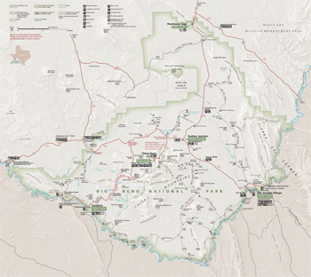 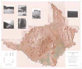 (click for larger maps) |
Big Bend National Park is in a remote part of southern Texas. Check supplies before leaving Alpine or Marathon. Gas stations and water sources are few and far between. Cell phone service is unreliable. Some park roads may require four-wheel drive.
Stay overnight at the Chisos Mountains Lodge (www.chisosmountainslodge.com). Camp at the Chisos Basin, Rio Grande Village, or Cottonwood campgrounds. Limited sites at Rio Grande Village are reservable Nov. 15—April 15 and at Chisos Basin Campground Nov. 15-May 31 (www.recreation.gov). Otherwise campgrounds are first-come, first-served. Full hookups are available at Rio Grande Village RV. Backcountry permits are available at visitor centers.
Park concession facilities are open year-round. Find groceries and camping supplies at Chisos Basin, Rio Grande Village, Castolon, and Panther Junction. Gas is sold only at Panther Junction and Rio Grande Village. Vehicle repairs and towing are available at Study Butte/Terlingua.
Border Crossings Crossing at the Port of Entry requires a passport. For current information about legal US-Mexico border crossings, ask a ranger or check the park newspaper or website.
Accessibility We strive to make our facilities, services, and programs accessible to all. Call us or check our website.
Things to See and Do
Big Bend offers superb walking, hiking, river running, and binding. For a full list, get the park newspaper, The Paisano. Visitor centers have activity schedules; road, river, and hiking guides and maps.
Hiking Walks and hikes range from short, self-guiding nature trails to challenging cross-park treks. Off-trail hiking requires proper gear and adequate supplies. Use a topographic map and know your route.
River Use The park administers 245 miles of the Rio Grande for recreational use. Get a river float permit (required for all boat use) and up-to-date river information at park headquarters or ranger stations. Be well-equipped and informed before running the river. There are no equipment rentals in the park. Contact the park for a list of river outfitters and for river levels. Check river levels before starting a float trip. The Rio Grande is a designated Wild and Scenic River for 196 miles along part of the park boundary and downstream.
Birding The park is a birder's paradise—over 450 bird species have been seen here. The larger migration occurs in spring. Ask a ranger about the best birding spots.
For Your Safety
Emergencies Call 911 in an emergency; response can be slow. The nearest hospital is in Alpine, 100 miles north of park headquarters.
Heat Can Kill Carry at least a gallon of water per person per day. When hiking, start your return trip before your water is half-gone. Treat spring water before drinking; do not drink river water. Wear a hat, long pants, long-sleeved shirt, and sunscreen. Springs are unreliable and often dry, despite what maps show. In summer, avoid hiking in midday. Instead, mimic wildlife by hiking in early morning or late evening. Tell someone where you are going and when you plan to return.
Driving Hazards Obey the park maximum speed limit (45 mph). Make sure your vehicle is in good mechanical condition and has a spare tire and tire-changing tools. When a water crossing floods, wait out the high water; don't let your vehicle get swept away. Stay on established roads. Check conditions before driving unpaved routes; storm damage may close backcountry roads. Seat belts are required in moving vehicles. Drive carefully at night because many animals are on the roads; if they are blinded by headlights, they might not move off the road.
Mountain lions and bears inhabit the park. Ask a park ranger about precautions you can take and how to react.
Encounters with Poisonous Wildlife Four rattlesnake species and one copperhead species live here, but are rarely seen by day. Stay on trails and use a flashlight at night. Snakes, scorpions, tarantulas, and most other wildlife generally will not harm you unless you harass them. Get prompt attention if injured.
Arroyos or washes can become raging rivers while you sleep. Do not camp in them or in other low spots. Watch for rapid changes in weather: extreme summer heat and thunderstorms and winter or early spring cold fronts.
Swimming The Rio Grande's strong currents, submerged snags, and drop-offs are extremely dangerous. Do not swim or wade in the river.
Border Awareness Big Bend shares 118 miles of international border with Mexico. Always be aware of your surroundings. Report unusual or suspicious activity.
Regulations
Firearms Texas state laws apply. More information at a visitor center or on the park website.
Protecting the Park Federal law protects all natural and cultural features in the park. Do not remove, collect, deface, destroy, or disturb rocks, wildflowers, tree limbs, soil, vegetation, wildlife, or artifacts.
Wood and ground fires are prohibited.
Camping is allowed in campgrounds and in the backcountry. Hammocks are permitted only if self-supporting. Backcountry overnight use requires a permit (fee).
In addition to the high country trails, there are rewarding hikes in lower, desert areas; ask a ranger. Smoking may be banned on some trails. Carry out all trash, including cigarette butts and toilet paper. Stay on trails to prevent erosion and other damage. Wear sturdy shoes and clothing. Carry tweezers; spines and thorns of cacti and other plants are hazardous.
Store food and toiletries in approved bear-proof container, vehicle, or food locker. Do not feed wildlife.
Pets are allowed only on roads, in developed campgrounds, and at primitive roadside campsites. They must be leashed at all times. Pets are prohibited on trails, in public buildings, and in the backcountry. Dispose of pet waste to limit the transfer of disease to wildlife.
Fishing in the park requires a free permit available at any ranger station. Fishing license not required.
Source: NPS Brochure (2019)
|
Establishment
Globally Important Bird Area — September 2001 |
For More Information Please Visit The  OFFICIAL NPS WEBSITE |
Documents
A Handbook for New Volunteers: Volunteers-In-Parks Program, Big Bend National Park (2020)
A Sampling of Archeological Resources in Big Bend National Park, Texas Intermountain Cultural Resources Management Professional Paper No. 79 (David W. Keller, William A. Cloud, Samuel S. Cason, Robert W. Gray, Richard W. Walter, Thomas C. Alex, Roger D. Boren, Andrea J. Ohl and Robert J. Malhouf, 2022)
"Age of Reptiles": Uncovering the Mesozoic Fossil Record in Three Intermountain National Parks (Vincent L. Santucci, Adam Marsh, William Parker, Dan Chure and Don Corrick, extract from Crossroads in Science, Spring 2018)
An Unofficial Guide to the Cemeteries and Gravesites, Big Bend National Park (Glenn P. Willeford and Gerald G. Raun, Date Unknown)
Archeological Assessment of Big Bend National Park (C. Britt Bousman and Margaret Rohrt, June 1974)
Backcountry Management Plan, Bend National Park (1995)
Bandit Raids in the Big Bend Country West Texas Historical and Scientific Society Publication No. 19 (W.D. Smithers, Sul Ross State College Bulletin Vol. XLIII No. 3, September 1, 1963)
Baseline assessment of instream and riparian-zone biological resources on the Rio Grande in and near Big Bend National Park, Texas USGS Water-Resources Investigations Report 2002-4106 (2002)
Big Bend National Park Ecology and Social Behavior of the Collard Peccary in Big Bend National Park Scientific Monograph Series No. 16 (John A. Bissonette, 1982)
Big Bend National Park: Handbook #119 (2000)
Big Bend National Park Project (1940)
Big Bend National Park: The Formative Years Southwestern Studies Monograph No. 60 (John R. Jameson, 1980, ©Texas Western Press, The University of Texas at El Paso, all rights reserved)
Big Bend: The Back Country Guide 1953-1954 (1953)
Briefing Statement: Visibility impacts at Big Bend NP from Carbon I and II power plants (July 15, 1997)
Carnivora (Mammalia, Felidae, Canidae, and Mustelidae) From the Earliest Hemphillian Screw Bean Local Fauna, Big Bed National Park, Brewster County, Texas (Margaret Skeels Stevens and James Bowie Stevens, extract from Bulletin of the American Museum of Natural History, No. 279, 2003)
Cave and Karst Resources Summary: Big Bend National Park, Texas (Gerald Atkinson, February 2016)
Chisos Mountains Backcountry Campsites (January 2020)
Comprehensive Interpretive Plan — Section One: Long-Range Interpretive Plan, Big Bend National Park and Rio Grande Wild & Scenic River (October 26, 2004)
Down to Earth at Tuff Canyon, Big Bend National Park, Texas (Daniel S. Barker, Texas Bureau of Economic Geology, 2000)
Draft General Management Plan / Environmental Impact Statement, Big Bend National Park, Texas (February 2003)
Early Settling of the Big Bend West Texas Historical and Scientific Society Publication No. 19 (Mrs. Joel E. Wright, Sul Ross State College Bulletin Vol. XLIII No. 3, September 1, 1963)
Ecology of the Carmen Mountains White-Tailed Deer (HTML edition) Scientific Monograph Series No. 15 (Paul R. Krausman and Ernest D. Ables, 1981)
Evaluating Conditions and Trends for Sky Island Forests in the Chisos Mountains, Big Bend National Park: Focused Condition Assessment Report NPS Natural Resource Report NPS/BIBE/NRR-2021/2290 (Andrew M. Barton and Helen M. Poulos, August 2021)
Final General Management Plan / Environmental Impact Statement, Big Bend National Park, Texas (May 2004)
Foundation Document, Big Bend National Park, Texas (May 2016)
Foundation Document Overview, Big Bend National Park, Texas (August 2017)
Geological, Geochemical, and Geophysical Studies by the U.S. Geological Survey in Big Bend National Park, Texas USGS Circular 1327 (J.E. Gray and W.R. Page, eds., 2008)
Geologic Map of Big Bend National Park, Texas USGS Scientific Investigations Map 3142 (Kenzie J. Turner, Margaret E. Berry, William R. Page, Thomas M. Lehman, Robert G. Bohannon, Robert B. Scott, Daniel P. Miggins, James R. Budahn, Roger W. Cooper, Benjamin J. Drenth, Eric D. Anderson and Van S. Williams, 2011)
Geology of Big Bend National Park, Brewster County, Texas Bureau of Economic Geology/The University of Texas Publication No. 6711 (Ross A. Maxwell, John T. Lonsdale, Roy T. Hazzard and John A. Wilson, June 1, 1967)
Gradsect and Field Sampling Plan for Big Bend National Park/Rio Grande National Wild and Scenic River NPS Natural Resource Report NPS/CHDN/NRR-2011/300 (Dan Cogan and James Von Loh, February 2011)
Historic Resources Management Plan, Big Bend National Park (William E. Brown and Roland H. Wauer, December 1968)
Historic Structure Report: Castolon Army Compound, Big Bend National Park, Texas (James Sheire and Robert V. Simmonds, June 1973)
Historic Structures Report: Hot Springs — Part I - Historical Data (Benjamin Levy, November 15, 1968)
Historic Structures Report: Hot Springs Complex, Big Bend National Park, Texas — Part I (A. Lewis Koue, April 1969)
Historic Structures Report: Buildings in Castolon Area — Part I - Abstract (T.N. Beatson, 1966)
Historic Structures Report: Old Castolon, Big Bend National Park, Texas — Part I (A. Lewis Koue, November 1969)
Hydrogeology, geochemistry, and quality of water of The Basin and Oak Spring areas of the Chisos Mountains, Big Bend National Park, Texas USGS Water-Resources Investigations Report 93-4112 (1993)
Implications of Climate Change for the Water Supply of the Chisos Mountains Developed Area NPS Natural Resource Report NPS/NRSS/CCRP/NRR-2019/2045 (David J. Lawrence and Amber N. Runyon, November 2019)
Inventory of Historic Structures, Big Bend National Park (William E. Brown, October 1964)
Junior Ranger, Big Bend National Park (2016; for reference purposes only)
Landscape of Ghosts, River of Dreams: A History of Big Bend National Park (HTML edition) (Michael Welsh, January 2002)
Large Carnivore Encounters at Big Bend National Park (Patricia Moody Harveson and David Price Rumbelow, extract from Texas Wildlife, March 2017)
Legacy Data Evaluation Report for Big Bend National Park and Rio Grande National Wild and Scenic River NPS Natural Resource Report NPS/CHDN/NRR-2011/301 (James Von Loh and Dan Cogan, February 2011)
Longhorns of the Big Bend: A Special Report on the Early Cattle Industry of the Big Bend Country of Texas (Robert M. Utley, April 1962)
Master Plan for the Preservation and Use of Big Bend National Park: Mission 66 Edition (March 1952-July 1962)
National Register of Historic Places Nomination Forms
Burro Mesa Archeological District (Timothy J. Seaman and Margaret Howard, September 1984)
Castolon Historic District (David G. Battle, February 1974)
Daniels Farm House (Arthur R. Gomez, February 4, 1986)
Homer Wilson Ranch (David G. Battle, February 1974)
Hot Springs (David G. Battle, February 1974)
Luna Jacal (David G. Battle, February 1974)
Mariscal Mine (David G. Battle, February 1974)
Sublett Farm, Stone Residence, Dorgan Residence (Rancho Estelle) (David G. Battle, February 1974)
Natural Resource Condition Assessment, Big Bend National Park NPS Natural Resource Report NPS/BIBE/NRR-2014/779 (Andy Nadeau, Shannon Amberg, Kathy Allen, Mike Komp, Kevin Stark, Sarah Garnder, Jacob Zanon, Eric Iverson, Jon Sopcak, Lindsey Danielson, Lucas Danzinger and Barry Drazkowski, February 2014)
Paleontological inventory of Paleozoic, Late Mesozoic, and Cenozoic plant, invertebrate, and vertebrate fossil species from Big Bend National Park, USA — over a century of paleontological discovery (Steven L. Wick, extract from Zitteliana: An International Journal of Paleontology and Geobiology, Vol. 95, November 19, 2021)
Park Newspaper (The Paisano)
2002: Spring • Summer/Fall
2003: Winter • Spring • Fall/Winter
2004: Spring • Fall • Winter 2004-2005
2005: Spring/Summer • Fall • Winter 2005-2006
2006: Summer/Fall
2008: Winter/Spring • Summer/Fall
2009: Spring/Summer
2010: 2010 Anniversary Edition • Winter/Spring 2010-2011
2011: Fall/Winter 2011-2012
2012 • 2013 • 2014 • 2015 • 2016 • 2016-2017 • 2018 • 2019 • 2020 • 2021-2022 • 2022-2023 • 2024 • 2025
Plants of Big Bend National Park (W.B. McDougall and Omer E. Sperry, 1951, reprint 1957)
Presidios of the Big Bend Area / Los Presidios del Area de Big Bend Southwest Cultural Resources Center Professional Paper No. 31 (James E. Ivey, 1990)
Protecting the National Parks in Texas Through Enforcement of Water Quality Standards: an Exploratory Analysis NPS Technical Report NPS/NRWRD/NRTR-94/18 (Ronald A. Kaiser, Steven E. Alexander and J. Porter Hammitt, November 1994)
Quality of Water from Test Wells in the Castolon Area, Big Bend National Park, Brewster County, Texas USGS Open File Report (Jack Rawson, October 1963)
Recreational River Use Management Plan, Big Bend National Park (March 1997)
Rehabilitation and Testing of 3 Water Supply Wells in the Castolon Area, Big Bend National Park (Larry Martin, May 14, 2002)
Rehabilitation of water wells at Castolon — Trip Report for Travel to Big Bend National Park on April 22-29, 2002 (Larry Martin, May 10, 2002)
Resource Management Tracks: Vol. 1 — Fall/Winter 2000 • Vol. 2 — Winter 2002 • Vol. 3 — Spring 2003
Resumen del documento fundacional, El Parque Nacional Big Bend (August 2017)
Running the Cañons of the Rio Grande (Robert T. Hill, extract from The Century Magazine, Vol. 61 No. 3, January 1901)
Shaded Relief Map: Big Bend National Park, TX Scale: 1:1000,000 (USGS, 1987)
Soil Survey of Big Bend National Park, Part of Brewster County, Texas (Rex A. Cochran and Jerry L. Rives, October 1985)
Soil Survey of Big Bend National Park, Texas (2011)
Soldiers, Ranchers and Miners in the Big Bend (Clifford B. Casey, September 1969)
Springs, Seeps and Tinajas Monitoring Protocol: Chihuahuan and Sonoran Desert Networks NPS Natural Resource Report NPS/SODN/NRR-2018/1796 (Cheryl McIntyre, Kirsten Gallo, Evan Gwilliam, J. Andrew Hubbard, Julie Christian, Kristen Bonebrake, Greg Goodrum, Megan Podolinsky, Laura Palacios, Benjamin Cooper and Mark Isley, November 2018)
Status of Climate and Water Resources at Big Bend National Park NPS Natural Resource Data Series NPS/CHDN/NRR-2022/2446 (Kara Raymond, Laura Palacios and Evan Gwilliam, September 2022)
Status of fish communities in the Rio Grande, Big Bend National Park, Texas - comparison before and after Spring 2003 period of low flow USGS Scientific Investigations Report 2005-5209 (2005)
The Association of Archaeological Materials with Geological Deposits in the Big Bend Regioni of Texas West Texas Historical and Scientific Publication No. 10 — Archaeological Issue (J. Charles Kelley, T.N. Campbell and Donald J. Lehmer, Sul Ross State Teachers College Bulletin Vol. XXI No. 4, September 1, 1940)
The Big Bend: A History of the Last Texas Frontier (Ronnie C. Tyler, 1975)
The Big Bend National Park: Descriptive and Historical West Texas Historical and Scientific Publication No. 13 — Big Bend National Park Issue (Ross A. Maxwell and Clifford B. Casey, Sul Ross State Teachers College Bulletin Vol. XXVIII No. 2, June 1, 1948)
The Big Bend of the Rio Grande: A Guide to the Rocks, Geologic History, and Settlers of the Area of Big Bend National Park Texas Bureau of Economic Geology Guidebook 7 (Ross A. Maxwell, February 1968)
The Civilian Conservation Corps in Big Bend National Park (©Kimberly Jackson, Master's thesis University of North Texas, May 2019)
The Glenn Springs Raid West Texas Historical and Scientific Society Publication No. 19 (Captain C.D. Wood, Sul Ross State College Bulletin Vol. XLIII No. 3, September 1, 1963)
The Impact of Human Use Upon the Chisos Basin and Adjacent Lands (HTML edition) Scientific Monograph Series No. 4 (Paul D. Whitson, 1974)
The Life of Everett Ewing Townsend West Texas Historical and Scientific Publication No. 17 (Lewis H. Saxton and Clifford B. Casey, 1958)
The Road Inventory for Big Bend National Park (Federal Highway Administration, April 1999)
Turtles of the upper Aguja Formation (late Campanian), Big Bend National Park, Texas (J. T. Sankey, from New Mexico Museum of Natural History and Science Bulletin No. 35, 2006, ©New Mexico Museum of Natural History and Science, all rights reserved)
Vegetation Classification List Update for Big Bend National Park and Rio Grande National Wild and Scenic River NPS Natural Resource Report NPS/CHDN/NRR-2011/299 (James Von Loh and Dan Cogan, February 2011)
Vegetation Inventory Project: Big Bend National Park NPS Natural Resource Report NPS/CHDN/NRR-2021/2275 (Dan Cogan and Chris Lea, July 2021)
Water supply for Persimmon Gap and Santa Elena ranger stations, Big Bend National Park, Brewster county, Texas USGS Open-File Report 58-9 (1958)
Wax, Men, and Money: A Historical and Archeological Study of Candelilla Wax Camps along the Rio Grande Border of Texas (Curtis Tunnell, ©Texas Historical Commission, 1981)
Wildland Fire Management Plan, Big Bend National Park (June 2005)
A Great Place For Birds (National Park Service: Reine Wonite, 6/21/2014, Duration: 11:14)
Big Bend In One Day (National Park Service: Reine Wonite, 4/5/2012, Duration: 6:32)
Floodplain Farms (National Park Service: Reine Wonite, 1/15/2013, Duration: 4:49)
This Video Could Save Your Life! (National Park Service: Reine Wonite, 11/20/2012, Duration: 7:57)
bibe/index.htm
Last Updated: 03-Feb-2025