OPPORTUNITY AND CHALLENGE
The Story of BLM
|

|
|
A MULTIPLE USE MANDATE:
The 1960s
Transition from custodianship to action programs is part of the
new dimension by which BLM is putting the public lands to work in
the public interest.
—Stewart Udall
The Third Wave, 1966
|
A MULTIPLE USE MANDATE
The 1960s
|
|
|
The 1960s brought rapid growth and fundamental change
to BLM—tumultuous change that permanently altered the Bureau's
course. President Kennedy took notice of the public lands, saying they
were vital to the nation's economic well-being but
suffered from "uncontrolled use and a lack of proper management." The
White House asked BLM to accelerate its inventory of the public lands
and develop a program of balanced use to reconcile resource
conflicts.
|
|
Overview |
|
A fledgling multiple use philosophy within the Bureau
was legally endorsed for the public lands in the Classification and
Multiple Use Act (CMU Act) of 1964. BLM was reorganized to reflect new
programs and authorities under this mandate: concerns for wildlife,
recreation, soil, and water resources were integrated into traditional
programs (range, forestry, lands, and minerals) through a land use
planning process.
|
|
|
Inspired by the conservation accomplishments of
Theodore and Franklin Roosevelt, Secretary Udall launched the
nation's "Third Conservation Wave" by requesting a
new legislative mandate for the public lands from Congress. Part of this
agenda included formal recognition of
multiple use management on BLM lands,
patterned after the Forest Service's Multiple Use Sustained Yield Act of
1960. Other components centered on getting BLM a more flexible land sale
authority and repealing outdated settlement acts.
|
|
The Third
Conservation
Wave |
|
But more than a push for legislation, the Third
Conservation Wave was a philosophy—one that viewed natural
resources as finite, interrelated, and vulnerable components of larger
systems. According to Udall, the Interior Department had "the prime
function of planning for the future of America and working to conserve
the natural resources which sustain its life." The Department's 1961
Annual Report spoke of a "quiet crisis" facing America's citizens, the
result of unplanned progress and explosive growth—something that
threatened the nation's natural resources and its citizens' quality of
life. Careful management of America's public lands could turn the tide,
and this could only be done with extensive planning and involvement from
the public.
Udall's program was only part of a growing national
conservation movement. With more leisure time on their hands, urban
Americans began to take notice of the public lands. Recreation groups
and conservation organizations gained many new members in the 1960s and
began to petition Congress for new parks, wilderness areas, and outdoor
recreation facilities. While BLM was not as well known by the general
public as were the National Park Service and the Forest Service (as
evidenced by the omission of BLM lands from the Wilderness Act of 1964),
the Bureau saw its local and regional constituents grow.
Citizen lobbies soon began to voice concern on
protecting endangered wildlife and combating pollution. By the end of
the decade, overall environmental quality emerged as a national issue.
The Third Conservation Wave grew into a demand for action from Congress,
the Interior Department, and BLM. According to natural resources
professor Sally K. Fairfax, "resource issues have never been discussed
with such emotional intensity as they were in the late 1960s and early
1970s."
|
|
|
Three Directors oversaw BLM's growth into a multiple
use agency during the 1960s: Karl S. Landstrom (February 1961 - June
1963), Charles H. Stoddard (June 1963 - June 1966) and Boyd L. Rasmussen
(June 1966 - June 1971). Landstrom supervised the drafting of
Secretary Udall's legislative agenda and worked to reduce the Bureau's
growing backlog of pending land applications. Stoddard began to
implement the new legislation and reorganized the Bureau to more
effectively manage its workload. To integrate all this activity on the
ground, Stoddard started the development of a multiple use planning
system on the public lands.
|
|
New
Leadership |
|
Boyd Rasmussen completed these tasks and introduced
initiatives of his own. Land use classifications under the CMU Act were
completed and a planning system was implemented in the field. Rasmussen
worked to "depoliticize" BLM's decisionmaking process, giving the
Department and Congress the task of deciding sensitive political issues,
such as grazing fee formulas. In addition, Rasmussen directed BLM's
early efforts toward obtaining a comprehensive management statute for
the public lands—a goal eventually attained through passage of the
Federal Land Policy and Management Act of 1976.
|
|
|
Reflecting their increasing visibility, 167 million
acres of BLM lands in the 11 western states were renamed the National
Land Reserve, and after implementation of the CMU Act, National Resource
Lands. At the end of the decade, BLM and Congress began to recognize
unique values on the public lands and designate special management
areas—natural areas, recreation lands, primitive areas, and
national conservation areas—to protect areas identified in the
classification process.
|
|
The National
Land Reserve |
|
In 1963 Secretary Udall designated Resource
Conservation Areas on BLM lands in each of the western states to
demonstrate how active management of the public lands would provide
benefits to all resources, including soil and water, forage (both
wildlife and livestock), and forests. Director Stoddard said "we hope to
acquaint every American with the thought that he is part owner of a
great national treasure—which is becoming ever more valuable as our
population grows." Secretary Udall urged conservationists to visit these
areas and follow their progress through on-the-ground inspections and
discussions at club meetings.
|
|
Resource Conservation
Areas |
|
This explosion of activity in the 1960s led to a new
land ethic, but it was not achieved without cost: controversies erupted
and debates intensified as BLM advanced its multiple use mission.
Reflecting America's growing concern for its public lands (and the
Bureau's new mandates), BLM's workforce grew from about 2,600 in 1960 to
4,300 in 1970, with its budget growing from $36 million to $118 million.
Revenues also grew—to over a billion dollars in 1969—thanks in large measure
to increasing Outer Continental Shelf revenues.
Many of BLM's 300-plus million acres of public domain
holdings in Alaska were destined for transfer to other federal agencies
and the state, once Native claims to the land were settled. Controversy
also broke out over allowable cuts for O&C forests, which wasn't
resolved until the end of the decade. In the minerals arena, Outer
Continental Shelf (OCS) lands, totalling 2 billion acres, witnessed
great growth in drilling activity.
|
|
|
A NEW CONSERVATION PHILOSOPHY
|
|
|
Under Karl Landstrom, BLM began to transform itself
from an agency primarily processing land and mineral applications into
an agency actively planning for the nation's future needs. The Bureau
stepped up inventories of public land resources and invited the public
to help decide how they should be managed.
The Bureau's state advisory boards and National
Advisory Board Council (NABC) were reorganized in 1961 to broaden their
representation by public land users. NABC's membership was increased
from 30 to 42, with representatives added from conservation groups,
county governments, forestry and mining interests, and the oil and gas
industry.
BLM was reorganized the same year; service centers in
Denver and Portland took over the functions of the Field Administrative
Offices and provided scarce skills (e.g., botany, hydrology, cultural
resource management) to the field. State Offices were strengthened,
bringing BLM's work closer to interested land users and groups, plus
state and local agencies. An Engineering Division was established in
Washington to assist in road building and other field office
construction activities.
Traditional programs continued to broaden their focus
to a multiple use framework. Range activities, for example, moved from
adjudication of grazing privileges to inventories of forage, soil, and
watershed conditions. BLM State Offices began to hire wildlife
biologists and outdoor recreation planners to implement new
programs.
|
|
|
During the 1950s and 1960s, a new breed of employee
entered BLM. He—or she—had college training in natural
resource management, usually a degree, plus membership in a professional
society (the Society for Range Management was founded in 1948; the
Society of American Foresters was founded in 1900). They brought with
them new educational backgrounds, new attitudes, and stronger multiple
use philosophies—and soon clashed with old-timers from the GLO and
the Grazing Service. George Turcott started his career with BLM as a
range conservationist in 1950 and rose through the ranks to become
Associate Director in the 1970s. According to Turcott, there was a
strong "don't-rock-the-boat" philosophy in the Bureau in the '50s and
early '60s. "We had all this [range] adjudication work to do and
everybody was trying to find ways to do it without making anybody
mad....We thought that there just had to be more to our jobs than
this."
|
|
Employees: A
New Breed |
|
SERVICE CENTER ROLE IN BLM
by Ed Dettman
Chief, Division of Administrative Services, BLM Service Center
Two service centers, one in Portland, Oregon and one
in Denver, Colorado, were established in 1963. They replaced Field
Administrative Offices (FAOs) in Salt Lake City, San Francisco, and
Portland. The service centers were premised on two fundamental
principles to achieve economies of scale through centralization of
administrative and technical equipment and personnel, and to provide an
effective setting for scarce skills which could be utilized jointly by
field offices and BLM's Washington Office.
The fundamental structure for both centers was the
same, but external factors resulted in significant differences in staff
sizes and assigned functions. For example, all financial processing
functions (voucher audit, payroll, and payments) were centralized in
Denver due to the Treasury Department's major disbursing office there.
Likewise, the initial start-up costs for mainframe computing equipment
and staffing dictated the formation of an Automated Data Processing
organization in Denver without a full counterpart in Portland.
In 1973, the Portland Service Center functions were
consolidated into the Denver Service Center. Based on cost efficiencies
and other factors, the Records Improvement Project and the Western Field
Office for reimbursable cadastral surveys for other agencies were left
duty-stationed in Portland with management oversight and direction from
Denver.
Throughout the 25 years of its existence, the role of
the Service Center has been constantly changing and always
controversial. Its sincerest critics highlight instances in which
Service Center initiatives have lacked either the field offices'
pragmatic sensitivity to political realities or the Washington Office's
sense of policy integration and timing. Its sincerest advocates point to
the unwavering connection between new skills, systems and technologies
which have come into the Bureau at all levels and their genesis and
support by Service Center personnel and initiatives. The Service Center
concept, constantly adjusted to meet changing needs and priorities, has
proven to be an enduring and essential element in the development of
improved technical, administrative, and scientific support for public
land management.
|
|
|
Like Turcott, many employees moved throughout the
West and to Washington to build their careers. And like their
predecessors, they recognized that the public lands had many values and
uses. They saw the Forest Service attain multiple use management
authority in the Multiple Use Sustained Yield Act of 1960, which
recognized wood, water, forage, wildlife, and recreation as resource
programs. At all levels of the organization, they wondered why BLM
didn't have the same mandate.
|
|
|
A LAND OFFICE BUSINESS
|
|
|
Much of the pressure to review and modernize the nation's land laws came
from a backlog of applications for agricultural entry that developed in
the 1950s. In 1961, BLM implemented an 18-month moratorium on accepting
any further applications so that it could reduce a backlog of more
than 60,000 applications—some pending for more than four years. BLM
needed to review its overall lands program and devise a better system
for handling applications. To back this up, BLM documented what happened
with applications under the Homestead and Desert Land Acts.
The 'Land Office business' has been very glamorous at times; sort of
romantic at times; but hectic most of the time.
— Karl S. Landstrom
|
|
|
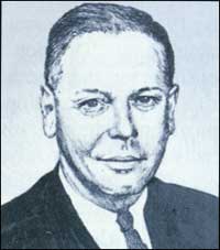
A DIRECTOR'S PERSPECTIVE: 1961-1963
by Karl S. Landstrom
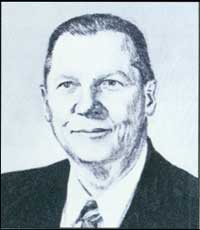
Karl S. Landstrom (Jennifer Reese)
|
Editor's Note: Karl S. Landstrom entered government as a farm economist
with the Department of Agriculture in 1937 and joined BLM in 1949. He has
degrees in economics from the University of Oregon and in law from George
Washington University. Landstrom was named BLM Director in 1961. In 1963
he became Secretary Udall's assistant for land utilization and later served
as his representative to the Public Land Law Review Commission's Advisory
Council.
I joined BLM's Portland regional office in
1949 as a land economist. In 1953 was transferred to Washington
because I had declined to classify certain public lands in Idaho as
proper for entry under the Desert Land Act—lands that were
unsuitable agriculturally or that had questionable water supplies. I
learned of my impending transfer two weeks before official notice from a
commercial land locator operating in Idaho.
While I was in Washington I served as Chief of the
Bureau's Branch of Land Classification in the Division of Land Planning.
I drafted regulations and manuals, wrote case decisions. and testified
on the Hill on pending lands legislation. I also developed a training
program on land appraisal standards.
I left BLM in 1959 to become a legislative consultant
to the House Committee on Interior and Insular Affairs, where I worked
until 1961. While there, I worked with Stewart Udall, who was a member
of the Committee. During the change in administrations I applied to be
Director of BLM through Mr. Udall. I understand that my appointment had
been endorsed by Wayne Aspinall, Chairman of the Committee.
By January of 1961 BLM was beset with an intolerable
backlog of land disposal applications. The backlog was an embarrassment
to BLM employees who worked with the public and were criticized as
though they, and not the land laws themselves, were the cause of the
situation.
Under a general land reform program instituted under
President Kennedy and Secretary Udall, the Bureau moved ahead with
deliberate speed. Associate Director Harold Hochmuth and I took
aggressive steps to remedy the situation, beginning with an 18-month
moratorium in 1961-62 and continuing into a legislative campaign, later
culminating in far-reaching reforms. Numerous drafts of proposed land
law legislation were submitted by BLM through the Department to the
Congress. The process had been set in motion leading to the
establishment of the Public Land Law Review Commission in 1964.
Something also had to be done to curb widespread loss
of public confidence in BLM, from both commercial and conservation
interests. BLM was sharply criticized by both grazing users, who
resented proposed cuts in grazing allotments, and wildlife interests,
who demanded that overgrazing be eliminated. The morale of employees in
the Bureau had suffered on account of these problems and an influx of
top personnel from outside the agency during the preceding eight
years.
As Director I took care to assure that most top-level
personnel were selected from within BLM ranks. In addition, I worked to
establish multiple use advisory boards that were more representative of
our many constituents. After my first meeting with BLM's National
Advisory Board Council, I recommended it be reorganized to reflect a
more balanced viewpoint toward public land administration.
Reorganization of the Council and the state-level boards was approved
by the Department
The Vale project in Oregon gave new life to rangeland
rehabilitation. It marked the beginning of a movement that proved highly
beneficial in improving rangelands—and general relations between
ranchers and BLM.
The project gained impetus in remarks I made at the
end of a meeting BLM personnel had with people in Vale County, Oregon,
including Congressman Al Ullman and Senator Wayne Morse. I said how much
I would like to see efforts toward range rehabilitation expanded, such
as increasing sagebrush removal and the planting of crested wheatgress.
Senator Morse asked how much money it would take. I made a quick mental
guess and said something like $15 million and three years. The formal
estimate was not much different. The upshot was we got immediate funding
for a pilot project in the Vale District. Other Senators soon got wind
of this work and obtained funding for their own projects.
The 1961 reorganization eliminating regional offices
established State Offices as the major second level of administration,
supported by service centers in Portland and Denver. Another
accomplishment was the decentralization of plat and tract book records
from Washington, DC to the land offices, further saving costs and
expediting service to the public. But to be very frank, this move was
stimulated by Secretary Udall, who learned there used to be a gymnasium
in the Interior building, which was now occupied by these voluminous
records. He asked me to clear them out, which I did; thereafter BLM
employees and others shot baskets and played volleyball as well as
enjoying the gym's new sauna!
I found it relatively easy to reinstate a
conservation-minded administration under Secretary Udall's "Third
Conservation Wave," although there were a number of difficulties along
the way. I found at times that members of the Secretariat were acutely
sensitive to pressures from commercial groups, especially when voiced
through members of Congress or their staffs.
After leaving the Bureau I worked as Assistant to the
Secretary for Land Utilization and served as the Department's member of
the Public Land Law Review Commission's Advisory Council. My greatest
achievement, in cooperation with friends from the Forest Service, was
preventing the substitution of 'dominant use' for 'multiple use'
management on the public lands. In the 1960s there were members of
Congress who felt that multiple use was merely a "meaningless jumble of
words."
Ed Cliff of the Forest Service joined with me in
defending multiple use, a professional concept going back to the first
conservation wave under President Theodore Roosevelt. This effort
culminated the work I began as Director to seek formal recognition of
multiple use management for BLM lands.
|
|
|
Farming on arid western lands was a formidable
challenge if one lacked a dependable water source. Only 14 percent of
Homestead applications were being allowed by BLM and, of these, only
about 50 percent went to patent and were transferred into private
ownership after residency and land development requirements had been
met. Only 17 percent of Desert Land Act applications were approved by
BLM, and only 1 percent ever went to patent.
About 120 patents were issued annually during the
1950s for public lands in the lower 48 states. In Alaska, 150 patents
were granted annually; in 65 years, only 3,200 patents were issued
(totaling 400,000 acres, or 0.1 percent of Alaska's total land area) out
of more than 10,000 claims.
|
|
|
|
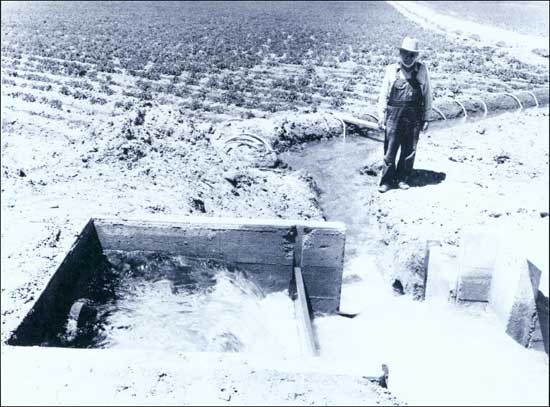
A successful desert land entry depended on a reliable water supply. (BLM)
|
|
|
When BLM's moratorium was lifted, BLM implemented
what Landstrom termed a "petition-classification system" that cut by
more than half the time to process applications. Demands for public
lands by communities and industries, however, continued to grow. The
Recreation and Public Purposes Act limited most sales of lands to 640
acres. BLM needed more flexibility, plus a mandate to classify and
manage its holdings.
In 1962 Assistant Secretary John Carver notified
Congress that the nation's nonmineral public land laws were in need of
modernization. BLM had shown that lands suitable for agriculture had
already passed out of federal ownership. The Bureau also needed formal
recognition of what it was beginning in earnest under Secretary Udall:
multiple use management of the nation's public lands.
Three acts passed in 1964 as part of a legislative
package arranged by Wayne Aspinall, Chairman of the House Interior and
Insular Affairs Committee. The Department got the Classification and
Multiple Use Act plus the Public Land Sale Act, while Aspinall got
approval for what he wanted, the Public Land Law Review Commission
(PLLRC). As part of this deal, the Wilderness Act, which did not include
BLM lands, was released from Aspinall's committee and passed both
Houses.
Aspinall had become increasingly wary of the
initiatives proposed by the Executive Branch—and disagreed with
their direction. Wanting Congress to reassert what he felt was its
traditional role in establishing land policy and supervising agency
activities, Aspinall was successful in insisting that the CMU and Public
Sale Acts be made temporary pending Congress' study of the public land
laws.
|
|
|
CLASSIFICATION AND MULTIPLE USE ACT
|
|
|
The CMU Act became BLM's biggest challenge—and
opportunity—of the decade. People in BLM, the Department, and
Congress differed greatly over the act's interpretation and
implementation. Central to this story were BLM's people: employees
determined how BLM got its job done and how it emerged as a land
management agency.
Though only a temporary authority, the CMU Act
provided a definition of multiple use as the "combination of surface and
subsurface resources of the public lands that will best meet the present
and future needs of the American people." The act listed ten elements of
multiple use, including wildlife, recreation, watershed, and range, and
directed BLM to classify its lands for retention in federal ownership or
disposal. But it did not specify how much land should be classified.
At the time it passed, no one in Congress (or BLM)
thought the Bureau could inventory and classify the majority of its
holdings in the 11 western states by the time the act was set to expire
in 1968. But it did, classifying more than 175 million acres for
retention in federal ownership under multiple use management (including
32 million acres in Alaska) and 3.4 million acres for disposal.
The CMU Act changed BLM forever: it would no longer
classify lands on a case-by-case basis, evaluating petitions from land
users. BLM now planned how all its lands and resources would be managed.
The Bureau no longer managed its holdings along individual program
lines; it integrated each activity into land use plans that would "best
meet the present and future needs of the American people." To do this
required involving the public in BLM's decisionmaking process.
|
|
|
Under Charles Stoddard, regulations for the CMU act
were developed with public input and comment. Draft regulations were sent to
interested individuals, organizations, state
and local governments, and other federal agencies for review, and they were discussed at 65
public meetings throughout the country.
|
|
CMU
Regulations |
|
The final regulations, adopted in October 1965,
incorporated many changes suggested by people outside BLM. As future
events would confirm, this was only the beginning of public
involvement for the Bureau.
The CMU Act required that BLM's classification
activities be consistent with state and local government programs,
plans, and zoning regulations. Proposed classifications were sent to
state and local governments and planning commissions. Proposals for
retention were sent to these entities as well as to public land users
and BLM's multiple use advisory boards.
BLM classified lands by collecting and analyzing
information on areas and their uses, and then contacted individuals,
groups, and agencies for further information. Meetings were held to
assess public attitudes and sentiments about retention or disposal
actions. BLM then drafted a proposed classification, published it in the
Federal Register, and held a public hearing. Only then were
classifications made final, through publication in the Federal
Register.
BLM met with the National Association of Counties,
the U.S. Conference of Mayors, the National League of Cities, and the
Council of State Governments to explain and implement the CMU program.
As a result of these discussions, BLM decided to work with pilot
counties in each western state to test the classification process.
County governments developed planning and zoning regulations and the
Bureau held an Urban and Rural Land Planning Conference in Reno, Nevada,
to explain the act and to develop classification procedures.
Valley County, Montana, was the first successful test
of the process. BLM's initial assumption that scattered lands would be
classified for disposal was opposed by the public—many of these
lands had scenic or recreational values or provided access to larger
public land areas. Local groups urged BLM to focus its efforts on larger
blocked areas under the CMU act, which BLM did. In 1966 BLM classified
its first lands under the act: 614,000 acres for retention in multiple
use management.
Another pilot project proved a formidable challenge:
Clark County, Nevada had several jurisdictions with competing annexation
programs. The CMU Act required that a single comprehensive plan be
developed for the area. To reconcile their differences, groups within
the county formed the Las Vegas Valley Planning Council, which eventually
devised a plan for the county's 7 million acres.
During this process, a recreation committee, with
involvement of local citizens, developed a plan for the Spring Mountain
area, which was classified for retention and then designated by
Secretary Udall in 1967 as the Red Rocks Recreation Lands—the first
such designation made under the CMU Act.
|
|
|
|
White Rock Spring in Red Rocks Recreation Area (BLM)
|
|
|
Other classification efforts confirmed that the
public favored retention of almost all the public lands in federal
ownership—and this from almost all BLM user groups. Livestock
operators, wildlife groups, and recreationists wanted continued use of
the public lands, and only retention could provide this.
Because the CMU act was a temporary measure, BLM's
first regulations provided that its classifications would expire at the
time the act did. But in 1967 BLM convinced the Department that CMU
classifications had long-term values and should be continued
indefinitely.
In implementing BLM's large-scale classifications,
Director Rasmussen convinced Secretary Udall to back the field's
broad-brush approach, with the idea that classifying public lands in
large areas decide their fate once and for all. Once this was done, it
would be difficult to undo—and only Congress or the Secretary could
do it—freeing BLM to manage its holdings under a multiple use
mandate. In this way, BLM's National Resource Lands were established, in
a manner somewhat analogous to the creation of a system of national
forests.
|
|
|
THE CLASSIFICATION AND MULTIPLE USE
ACT
by Irving Senzel
Editor's Note: Irving Senzel began his career with
the General Land Office in 1939. In his more than 30-year career, Mr.
Senzel held many positions. including Chief of the Division of Lands and
Minerals Standards and Technology under Director Stoddard and Assistant
Director for Lands and Minerals under Director Rasmussen. In these jobs he
was responsible for overseeing implementation of the Classification and
Multiple Use Act of 1964.
What role did I play in the CMU Act program? Well, I
had nothing to do with drafting the law. That was done in the House
Interior Committee. However, because of the Lands and Minerals positions
I held (Division Chief and later Assistant Director), I became involved
in its interpretation and implementation.
After the House enacted the bill, I was told not to
propose any amendments; I initiated two letters to the Senate Interior
Committee interpreting provisions of the bill that I thought were
ambiguous. These letters later proved important to our defense of our
program, particularly since they dealt in part with the question of
segregating lands from locations under the mining laws. Our remarks were
significant since the Senate passed the House bill without amendment.
In the implementation of the CMU Act, I had primary
responsibility for the preparation of classification regulations,
drafting of manual sections on public-participation procedures, and
monitoring progress of the program. In this work, we were plowing new
ground in active give-and-take with the public in the public lands
areas. We were anxious to make sure that our field efforts were
conducted in a fully professional, objective manner.
The field undertook program operations with
enthusiasm. BLMers spent long hours, including evenings and weekends, in
preparation, public meetings, discussions with State and local
officials, show-me tours, and what not. All this soon resulted in a flow
of classification orders for publication in the Federal Register.
Our progress apparently took some people by surprise, for from the Hill
and a couple of other places came demands that BLM stop its work under
the Act.
In a Director's staff meeting called to discuss this
development, I argued against acceding to this demand chiefly because
(1) what we were doing was consistent with the directives of the law,
(2) our interpretations, proposed regulations and criteria, and proposed
field procedures were all exposed to detailed public and Congressional
scrutiny before adoption, (3) the general public in the public-lands
areas responded well to our operations, and (4) surrender without a
fight would be a serious blow to field morale, which was then very high.
Field personnel were doing a job they thought needed to be done.
We took the matter up with Secretary Udall, who then
gave us the green light to continue with our work. The Hill was informed of this decision.
When the statutory period terminated, the field had
completed classifications for more than 150 million acres, a remarkable
achievement especially since the Bureau received no additional funding
from the Act to do this pioneering work.
|
|
|
Proof of the public's support for retention of BLM
lands in public ownership came in July 1968, when BLM proposed to
classify 119,000 acres of lands in Pima and Pinal counties, Arizona, for
disposal (along with 354,000 acres for retention). Objections from the
public and user groups caused BLM to abandon the proposal; the acreage
to be disposed eventually dropped to 6,600 acres.
Some in Congress—Wayne Aspinall in
particular—strongly disagreed with BLM's approach, asserting that
the agency was stretching its authority. A critical test of BLM's
strategy came when Aspinall wanted to extend the Public Land Law Review
Commission Act without the CMU Act. The Senate (Senator Jackson in
particular) would not agree to this request and extended both acts until
1970.
While lands classified for retention were segregated
from settlement laws, they were not precluded from mineral leasing or
most mining activity. Less than 1 percent of the lands classified for
retention were segregated from mining, and these were generally areas
under 1,000 acres identified as valuable recreation areas, wildlife
habitats, or cultural resource sites.
Once the public land tenure issue was decided, BLM
was ready to recognize special values on the public lands and designate
special management areas. According to Assistant Director Jerry
O'Callaghan, "the classification [process] identified public values
which could have been lost in a case-by-case classification." BLM's
first primitive areas, Paria Canyon and Aravaipa Canyon, were created
through BLM land classification actions in 1969, along with the
Vermillion Cliffs Natural Area.
According to former Director Marion Clawson, the
Classification and Multiple Use Act "gave the Bureau a psychological
lift that has led to its taking the initiative more and more often." The
act made public involvement and interagency cooperation a permanent part
of public land management. By July 1968, 188 local government boards and
commissions had reviewed proposed classifications. More than 15,000
local officials participated in CMU public meetings and hearings.
|
|
|
THE PUBLIC LAND SALE ACT
|
|
|
The Public Land Sale Act allowed BLM to sell tracts
of land up to 5,120 acres "for the orderly growth and development of
communities" after local zoning and planning had taken place. To
implement the act, BLM District Managers met with local governments and
planning commissions in ten test counties to develop cooperative
procedures.
The Act required that lands be classified under the
CMU Act before they could be sold. Lands were then appraised and sold at
fair market value to state or local governments or high bids were taken
at auction from private individuals, organizations, or corporations
meeting the act's criteria.
|
|
|
REORGANIZATION
|
|
|
Using the CMU Act as his authority, Charles Stoddard
reorganized BLM in 1965 to integrate new programs. New divisions
(wildlife, recreation, and watershed) were created in the Washington
Office and the Bureau's line managers—State Directors and District
Managers—were strengthened with new responsibilities to coordinate
on-the-ground activities. Budget work and program evaluation were moved
from BLM's program staffs and consolidated under the Assistant Director
for Administration and the Division of Program Evaluation to further
integrate and organize the Bureau's activities.
By this time, added workloads and management
responsibilities in the field were making BLM District Offices too large
for managers to have a working knowledge of everything that occurred in
their districts. An organizational study of BLM in 1964 by Dr. George
Shipman of the University of Washington recommended that BLM change its
organizational structure and management systems to provide better
service to public land users. Another major conclusion, according to
former Colorado State Director Dale Andrus, was that "coordinated land
use decisions had to be made at the grass-roots level."
|
|
Detached
Resource
Area Offices |
|
A NEW EMBLEM FOR BLM
by Charles H. Stoddard
The tired old emblem of user groups—the logger,
cowboy, oil driller, and surveyor—produced a poor image, never had
Bureau acceptance, and was too busy for reproduction. Accordingly, we
held a contest in 1965 to develop a new emblem. The winning emblem
features today's winding river, grassland, a conifer tree, and a
mountain, snow-capped as a result of mountain climber Udall's
suggestion.
|
|
|
Serving as a Management Analyst and Assistant
Director in Washington in the 1960s, Andrus was responsible for much of
the organizational work in creating BLM Resource Area Offices. According
to Andrus, it was critical that the Bureau designate a single official
to manage and be responsible for all BLM activities in a specific
geographic area. These activities included land use planning, managing
minerals and natural resources, processing lands cases, and providing
information to the public. A general rule of thumb of three to four
areas per district was set forth in the implementing instructions,
according to Andrus. "Criteria used to identify Resource Area boundaries
were kind and amount of workload, geographic barriers, political
subdivisions, and watershed basins."
By 1965, several Bureau field offices had already
followed Idaho's lead in establishing "Division Managers" within
Districts, making them responsible for management of specific geographic
areas—with the District Offices providing planning and program
coordination, plus technical and administrative assistance. Resource
Area Offices were officially recognized in July 1966 in BLM Manual
Section 1213.37. Special project offices or unit offices in O&C
Districts (e.g., Tillamook, Oregon) were already performing this
function; in other locations (e.g., Durango and Meeker, Colorado) former
District Offices were converted into detached Resource Area Offices
during statewide reorganizations.
|
|
|
PLLRC: A CLOSER LOOK AT PUBLIC LAND MANAGEMENT
|
|
|
At the same time BLM was classifying its lands for
retention in multiple use management or disposal to the private sector,
the Public Land Law Review Commission was studying the nation's 3,000
land laws and federal management of the public domain to identify
problems and recommend new policy, programs, and legislation. Its
Chairman, Wayne Aspinall, had strong disagreements with BLM and the
Department over how the Bureau was carrying out its
responsibilities.
The Public Land Law Review Commission (PLLRC) was
established mainly through the efforts of Wayne Aspinall. While
Presidents Kennedy and Johnson and the Interior Department were
introducing conservation related legislation to the Congress, Aspinall
was trying to get Congress to rebuff these initiatives and establish
federal land policy by itself. At the commission's first meeting,
Aspinall was named chairman. Other members included six senators, six
representatives, and six presidential appointees. An Advisory Council
was formed with liaison officers from each of the land-managing agencies
plus 25 members appointed by PLLRC to represent land users.
PLLRC commissioned studies on commodities and land
uses, intergovernmental relations, regional and local land use patterns,
government management of public lands, and historical development of
public land laws. Its reports included studies of fish, wildlife,
forage, and mineral resources; OCS lands; future demands for
commodities; withdrawals and reservations; and virtually every other
land management policy or activity BLM was involved in. Conservation
groups and most of the public, however, were not involved in this
process and ignored it, focusing their attention on wilderness debates,
oil spills, and Alaska policies, plus passage of the National
Environmental Policy Act (NEPA) and other conservation legislation.
|
|
|
A DIRECTOR'S PERSPECTIVE: 1963-1966
by Charles H. Stoddard
Charles Stoddard (Jennifer Reese)
|
Editor's Note: Charles Stoddard worked for the U.S.
Forest Service, the Bureau of Agricultural Economics and private
research foundations, including Resources for the Future, and was
director of Secretary Udall's Program Staff before serving as Director
of BLM. He holds degrees in forestry and forest economics from the
Universities of Wisconsin and Michigan.
During three years as Director, I oversaw major
changes in organization structure, program direction, and land-use
planning—changes that were designed to help BLM clarify its goals
and evolve into today's multiple-use organization.
Prior to my arrival, BLM had Professor George Shipman of the University
of Washington study the Bureau's organization structure and
recommend improvements. He saw the BLM as divided,
uncoordinated, and unilateral in structure, citing its case-by-case
orientation, its custodial (as opposed to managerial) approach, and its
lack of a mission or goal. He went on to say, "Unless you can spell out
a goal, a set of objectives, I can't be of much value to you nor can I
come up with any organizational recommendations. Organization must be
tailored to mission."
I feel my major contribution as Director was to help
define our problems so that we could set forth clear objectives, and
tailor BLM's organization structure to carry out programs that would
meet these objectives.
Following the analysis made by Professor Shipman, BLM
went through a major Washington Office reorganization, going from a
five-functional group structure (survey, minerals, lands, forestry, and
range) to a basic staff and line structure. The line established was
from Assistant Directors through the State Offices to the Districts. In
addition, we replaced single purpose, case-by-case directives with
coordinated instructions to field offices, amidst cries of protest from
guardians of the status quo.
In lieu of a regional office set up, Service Centers
were established in Denver and Portland to provide technical support to
State and District offices. The Boise Interagency Fire Center was
established in 1965.
Legislative Developments—Except for the Taylor
Grazing Act of 1934 and the O&C Forestry Act of 1937, BLM was hemmed
in by old disposal laws and special bills for relief of individual
situations. This deadlock was broken by providing classification
criteria in the new Classification and Multiple Use Act, which were
applied to the lands prior to their retention or disposal. Because there
would be impacts arising from changes in land use, we made certain that
regulations provided a system of public meetings at the grass roots to
institutionalize local participation in the land management
decisionmaking process. This began a process for stabilizing the tenure
of retained lands by the Public Land Law Review Commission and,
ultimately, FLPMA.
Resource Management Programs—Resource project
work varied considerably in the field. It was carried on without effective technical
guidelines from Washington or State Offices and was carried out by user
request rather than program need. For example, when BLM field staffs
initiated soil and water conservation projects, many were installed off
the contour—thus increasing erosion.
BLM's grazing management lacked modern range
management techniques such as rotation grazing. I asked Dr. Glen Fulcher
from the University of Nevada to head up our Range Staff. Fulcher
brought in Gus Hormay, a Forest Service researcher who had developed a
"rest-rotation" grazing system designed to bring about range
reestablishment in over-grazed areas without reseeding. Enthusiasm for
this new approach grew: when I left BLM an average of one rancher per
District had a rotation plan under practice.
Management of the Bureau's forest land was subject to
considerable pressure from user groups seeking regular increases in
allowable cut limits. We curtailed excessive expansion of these
sustained yield limits in several confrontations where the public
interest was able to override local pressures.
Much of the Bureau's Soil and Moisture funds were
allocated to range improvements—not to eroding lands nor to
efforts to restore overgrazed lands. A special Frail Lands Study,
undertaken in 1964 by Cyril Jensen and Clarence Forsling, identified
about 45 million acres of public land on which accelerated erosion was
taking place. Senator Hayden was instrumental in obtaining
appropriations for BLM to begin genuine erosion control efforts.
Although the Bureau had authority for managing
wildlife habitat under the Taylor Grazing Act, no active program was in
operation nor were funds directed to this purpose. In 1964, Bob Smith
(former Arizona Game and Fish Director) put wildlife on an equal footing
with forestry and recreation. Al Day, former Director of the Fish and
Wildlife Service, examined the wildlife program and laid out plans for
habitat improvement, location of wildlife managers in Districts with
heaviest wildlife resources, and a variety of special projects.
Land Use Planning—Multiple use management plans
had never been instituted in the Bureau because of its single-purpose approach (range,
forestry, etc.). A workable planning system, the Unit Resource Analysis, was implemented
after considerable testing in the field. URAs provided the Bureau's first means of integrating
all project work and land use for a District into a management system.
Personnel Matters—Modern resource management
requires not only technical expertise from many disciplines but also
knowledge of social sciences and administrators who can blend all
disciplines into a unified program. I sought to encourage "generalists"
in the Bureau and to give them a separate ladder for advancement.
Lacking any trained land use planners in BLM, I instituted a special
program at the University of Wisconsin in regional planning.
Minority group employment in BLM lagged. This was
partly because of inertia and a lack of people trained in the fields
needed by BLM. I initiated efforts to recruit Native Americans in areas
near BLM operations plus blacks from southern agricultural schools.
In my opinion the Bureau of Land Management has some
of the best trained personnel available in government. I'm proud to have
been associated with these fine employees and look back with pride on my
years with the BLM. To assure a solid future, BLM must remain a land
management agency—in place of its real estate disposal past.
|
|
|
In 1970 PLLRC released its report, "One Third of the
Nation's Land." Reflecting Aspinall's sentiments, it asked Congress to
establish policy on a variety of public land matters. The report
recommended that all federal lands not specifically set aside by
Congress, such as national forests and monuments, be made eligible for
disposal—but in another section stated that the nation's policy of
disposing the unappropriated public domain be reversed.
PLLRC also proposed merging the Forest Service and
BLM into a Department of Natural Resources (a proposal soon taken up by
Presidents Nixon and Carter). The commission recommended that Congress
limit the exercise of Executive authority, especially on withdrawals,
and called for Congress to determine revenues for consumptive uses of
federal lands. PLLRC further recommended grants of federal funds to
states and counties in lieu of taxes.
In these proposals, PLLRC proved prophetic: Congress
soon began prescribing specific management techniques and standards to
be followed by federal agencies, thus limiting their traditional
discretion in management actions and policy implementation. But PLLRC's
report, though voluminous, was often contradictory. Its recommendation
to classify public lands for their "highest and best use" was seen as an
endorsement of dominant use over multiple use on the public lands.
Life Magazine reported that the PLLRC report
was written by people "who believe in the commodity approach...and
consequently it gallops headlong in the wrong direction." Sports
Illustrated said that Aspinall's commission recommended "accelerated
exploitation and disposal of the lands" and that its recommendations
were made "on the basis of little publicized hearings and highly
secretive deliberations." Professor Paul Culhane reflected that "many of
the commission's recommendations appeared to have little impact on
federal policy, perhaps because they seemed too pro-industry and out of
step with the times when released during the fervent early years of
environmentalist activism. However, the PLLRC firmly asserted that the
era of disposal of public lands was over."
Thus, while President Nixon proclaimed NEPA as
heralding the start of an environmental decade in 1970, PLLRC "played to
an empty theater" according to Dr. Sally Fairfax. But few others in
Congress or elsewhere had examined public land issues. PLLRC's studies
and recommendations were available when the public and Congress were
ready to address public lands issues—which would be soon. PLLRC compiled
a great deal of information and opened a discussion that continued
through passage of the Federal Land Policy and Management Act.
|
|
|
PLANNING: THE DEVELOPMENT OF MANAGEMENT FRAMEWORK PLANS
|
|
"If we are to maintain man's proper relationship with nature...we must
broaden the role of resource planning in the
management of our national affairs."
[DOI Annual Report - 1961]
Implementing multiple use management on the public
lands required planning. And effective planning required that the public
be involved in BLM's decisionmaking process. Once this was begun, there
would be no turning back; the public took an increasing interest in BLM
and increasingly did not agree with the agency's management.
The story of planning in the 1960s is the eventual
development of Management Framework Plans (MFPs), integrating all of the
Bureau's on-the-ground activities into a single effort. As a first
step, the Bureau needed a way to develop land use plans independently of
the applications it received. The Master Unit system was created in 1961
for BLM to decide on land tenure before reacting to specific land-use
applications. Units of study (Master Units) were defined, information
gathered, and the data analyzed to determine potential land uses. The
Bureau then categorized its lands into title transfer projects, land
management projects, and residual management areas where detailed
land-use plans would not be appropriate.
In 1963, working with state agencies and county
commissions, BLM developed a plan to coordinate Recreation and Public
Purposes Act (R&PP) land transfers in the Las Vegas area and manage
the remaining public lands. Citizen groups were involved on a recreation
subcommittee while county commissions developed overall plans.
Once the CMU act passed, BLM Director Charles
Stoddard created the Office of Program Evaluation in Washington to
develop a multiple use planning process for the field. BLM's challenge
was to devise a planning system that would incorporate individual
activity plans (master unit, allotment management, and watershed plans)
into more general area plans. The system had to be clearly understood by
employees, constituents, and the public, and be standardized enough to
ensure consistent results across the Bureau. It also needed to integrate
the resource allocation techniques used by different programs.
Stoddard, originally from Wisconsin, knew of a
successful land use planning system used in his state during the 1920s
and 1930s. The system featured land classification and zoning
procedures—plus participation and approval from the public before
final decisions were reached—and served as a model for BLM's
system. Nevertheless, implementation of a comprehensive planning system
represented a major organizational change for the Bureau. Field managers
needed to be convinced that a uniform, Bureauwide land use planning
system was needed when they were used to doing these jobs in their own
ways. Several attempts and many years were necessary to implement a
workable system. To encourage the process, Stoddard began sending BLM
managers to the University of Wisconsin for training in regional land
use planning.
BLM's first step was to identify planning units and
collect resource data. Unit Resource Analyses (URAs) were prepared to
summarize resource inventory data collected in planning units.
Social and economic data were also collected so that they could be
considered when it came time to develop management alternatives.
But then what? More than a few field managers were
apprehensive about a system that would require public involvement and
identify management alternatives before BLM arrived at decisions. Why
should BLM tip its hand to users and the public in the early stages of
its decisionmaking process? In many districts, BLM would have enough
controversy to handle once a final decision was made.
Finding a way for each program and the public to
identify and advocate resource uses—and follow them through the
process so that no potential was overlooked—was tricky. How would
disagreements be resolved? How much would the public be involved in
decisionmaking? BLM planners had a long way to go to convince BLM field
offices that planning was a good and necessary thing—and that using
the system to address and resolve differences among land users would
save the Bureau from repeated headaches in the future.
An important step in getting MFPs off the ground was
testing the process in the field and showing it would work. In 1968, Art
Zimmerman, District Manager of the Montrose District in Colorado, asked
to test the process to see if it could help resolve strong disagreements
on resource allocations among the district's user groups. After this and
further tests in Oregon and California proved successful, MFPs were
ready to be implemented in the field.
|
|
|
MINERALS
|
|
|
According to Director Stoddard, "BLM's minerals
activity could hardly be called a program" in the early 1960s. The
Geological Survey classified minerals, approved exploration and mining
plans, and monitored this activity, which "prevented BLM from giving
effective direction to location, rate, and timing of mineral exploration
and development."
Secretary Udall and BLM worked throughout the decade
to develop a minerals policy, one that ensured optimum returns of
revenue to the Treasury, resolved land use conflicts, and planned for
adequate mineral reserves in the future. The Interior Department's
Annual Report for 1962 had this to say about minerals: "In the past 30
years, this Nation has consumed more minerals than all the peoples of
the world had previously used....That current demands are being met
without difficulty is primarily due to the immense technical and
exploratory efforts of the 1940s and early 1950s. But with national
requirements constantly increasing, the present availability of raw
materials will not continue unless prompt action is taken to look to the
years ahead."
|
|
|
Before the mid-1940s, coal provided over half of
America's energy needs. Oil and gas rapidly supplanted it as the
nation's preferred fuel after World War II. However, interest in public
coal reserves revived in the 1960s due to advances in coal utilization,
processing, and transportation. Coal in the West was viewed as an
important future energy source because of its low
sulfur content—an important asset in reducing
air pollution.
|
|
Coal |
|
Half of the country's coal reserves occur west of the
Mississippi River and the government owns 60 percent of it, or about a
third of the nation's total. BLM was sitting on 75 million acres of
federally owned coal. Major hydroelectric facilities had already been
built and few new sites were available. Early warnings about declining
oil and gas supplies were largely unheeded by the public. The Interior
Department, however, readied itself for future demands for coal.
Secretary Udall created the Office of Coal Research to complement the
Bureau of Mines' research efforts.
|
|
|
|
Major U.S. coal fields
|
|
|
During the 40 years following passage of the General
Mineral Leasing Act of 1920, GLO and BLM issued an average of only
four coal leases a year. From 1960-69, that average increased to 31 per
year. By 1971, 17 billion tons of federal coal were under lease, enough
to satisfy America's coal needs for 25 years. Most of these leases,
however, were speculative: 70 percent were not producing. Major development of coal
came soon after, though, following the energy crisis of 1973.
|
|
|
Oil shale reserves were estimated to amount to 2
trillion barrels of petroleum, compared to onshore and offshore
oil reserves of 300 to 500 billion barrels. The problem with developing
oil shale, however, was the extreme heat (and expense) needed to process
the shale.
|
|
Oil Shale |
|
Secretary Udall appointed an Oil Shale Advisory Board
to study the situation and recommend policy. Because the group had
diverse points of view, an interim (but never final) report was released
in 1965. The board agreed that knowledge of oil shale needed to be
enhanced and that "the national interest is best served by the immediate
commencement of oil shale development."
In 1967, Udall announced a tentative oil shale
program to clear title to oil shale lands by withdrawing them from other
forms of mineral entry, blocking up oil shale ownerships through an
exchange program, issuing provisional development leases, and
cooperating with industry to develop better processing methods. The
program sought to encourage oil shale development, prevent speculation,
promote good conservation, and bring money into the Treasury. In late
1968 a number of oil shale leases were opened to competitive bidding,
but the offers were rejected by BLM as being too low.
|
|
|
The oil and gas leasing frenzy that characterized the
late 1950s stabilized in the 1960s. Onshore fluid mineral
revenues rose modestly, from $178 million in 1961 to $233 million in 1971.
|
|
Oil and Gas |
|
Exploration continued throughout Alaska. By the
middle of the decade, oil and gas accounted for 60 percent of Alaska's
mineral output and brought in $19 million to the state treasury. By
1970, there were five oil fields on the Kenai Peninsula and Cook Inlet
area and nine natural gas fields.
|
|

|
|
Offshore oil drilling rig in the Gulf of Mexico (BLM)
|
|
|
The biggest oil strike was at Prudhoe Bay by Atlantic
Richfield in 1968. Alaska estimated that revenues to the state could run
as much as $1 million a day—which they eventually did. What was
needed was a pipeline to get the oil out of Alaska. In 1969, ARCO,
Humble, and British Petroleum announced plans to build a pipeline from the
North Slope to Valdez, stretching 800 miles across the state and costing
$900 million. In June the Trans-Alaska Pipeline System—later the
Alyeska Pipeline Company—filed a right-of-way application with
BLM, with plans to start construction in the spring of 1970. These plans
were contingent on settling Native claims and were ultimately affected
by the passage of the National Environmental Policy Act.
|
|
|
Revenues from the Outer Continental Shelf lands grew
dramatically in the 60s, from $442 million in 1961 to $1.1 billion in
1971. Development of this resource occurred from the humblest of
beginnings in 1959, when only $3.4 million was collected.
|
|
OCS Lands |
| Outer Continental Shelf (OCS) Mineral Leasing Statistics 1961-1970 |
Fiscal
Year |
Gulf Coast |
West Coast |
Total Production |
Active
Leases | Acres
(millions) |
Active
Leases | Acres
(millions) |
Natural Gas
(1,000 cu. ft.) | Petroleum
(million bbl) |
| 1961 | 458 | 1.93 |
— | — | 298.1 | 48.5 |
| 1962 | 851 | 3.74 |
— | — | 354.5 | 65.5 |
| 1963 | 826 | 3.59 |
57 | .31 | 473.6 | 87.7 |
| 1964 | 824 | 3.50 |
57 | .31 | 526.2 | 107.4 |
| 1965 | 797 | 3.40 |
135 | .76 | 621.7 | 122.5 |
| 1966 | 792 | 3.29 |
116 | .65 | 645.6 | 145.0 |
| 1967 | 870 | 3.67 |
84 | .47 | 1,007.4 | 188.7 |
| 1968 | 815 | 3.41 |
85 | .44 | 1,187.2 | 221.9 |
| 1969 | 939 | 3.94 |
77 | .40 | 1,524.2 | 269.0 |
| 1970 | 931 | 3.93 |
70 | .36 | 1,954.5 | 312.9 |
|
|
In 1963 BLM opened an OCS leasing office in Los
Angeles and held its first lease sale on the West Coast, bringing in
$12.8 million for 58 tracts. But most offshore action remained on the
Gulf Coast. In 1963, OCS oil production off the Louisiana coast
represented 27 percent of total federal oil production, while gas
represented 37 percent. By 1967 more than 4 million acres of OCS lands
were leased by BLM, but this total represented less than 1 percent of
OCS lands with ocean depths of less than 600 feet.
|
|
|
ALASKA
|
|
|
The two biggest issues for Alaska in the 60s were the selection of
statehood grant lands and settlement of land claims made by Alaska
Natives. Alaska handled its state selections through its Division of
Lands. The Division's first chief was ex-BLM employee Roscoe
Bell, who had been Associate Director and then Regional Administrator in
Portland under Marion Clawson.
Bell's plan was to select lands that would further
the economic development of the state. Four million acres were selected
a year, or as he put it, "an area the size of Rhode Island every two
months," so that all 103 million acres due the state would be selected
in the 25 years allowed by Congress.
Alaska's selections during this period were
characterized by state officials as "small but carefully calculated." In
1964, the state selected lands at Prudhoe Bay that it thought had oil
and gas potential. How right they were!
To help the state select land, BLM received
additional funding for its surveys. Only 1 percent of the state was
surveyed under the Public Land Survey System by the time Alaska was
granted statehood. The Bureau therefore concentrated its efforts on
surveying state selections, planning to survey 4 million acres a year to
match Bell's selection schedule.
Alaska's sheer size required that new survey
techniques be developed. Electronic distance measuring devices were used in
the field; helicopters marked section corners and transported survey crews
throughout the state.
Problems immediately arose with the program, however.
The state refused BLM's request to select large areas forming "logical
topographic-geographic-economic units." Alaska interpreted its right to
select "reasonably compact tracts" in its statehood act as being 5,760
acres—a quarter township. With involvement of Alaska's
congressional delegation and Assistant Secretary John Carver, the issue
was resolved in the state's favor.
Alaska's biggest problem proved to be the claims of
its Natives. The U.S. had not recognized aboriginal title for Alaska
Natives, who consist of Eskimos, Aleuts, and Indians, as it did for
Indians in the lower 48 states. Instead, in 1906 Congress passed the
Native Allotment Act, which allotted each Indian and Eskimo 160 acres of
nonmineral public land but made no reference to Aleuts. Because the law
had no provision for passing title, the "allotments" were nothing more
than perpetual reservations. Provisions for patent weren't made until
1956; by 1962, only 101 allotments had been made under the
act.
Beginning as early as 1950, Alaska Natives petitioned
to have lands restored to them. In June 1963, BLM stopped processing
state selections in areas specifically protested by Natives until
Congress could act on their claims. By 1966, Alaska Natives claimed some
230 million acres of land.
Secretary Udall initiated an informal freeze that
stopped approvals on all state selections. Alaska then took Udall to
court. Facing an adverse ruling in December 1968, Udall formally
withdrew 260 million acres of public land from appropriation, asking
Congress to resolve the situation. Because Native claims were also
delaying selection of a route for the Alaska pipeline, Congress enacted
the the Alaska Native Claims Settlement Act in 1971.
|
|
|
THE ALASKA STATE LAND SELECTION PROGRAM
A STATE PERSPECTIVE
by Roscoe E. Bell
Former Director of Alaska Division of State Lands
I had worked for BLM in Alaska in the mid-1950s. When
I returned to Alaska as State Director of Lands, my acquaintance with
Alaska and with BLM personnel was very helpful, and very important, and
I just wanted to compliment the BLM personnel in Alaska. They leaned over
backwards to help us get started in the State selection process. Of
course, they trained some of the people that we hired away from them,
but it was a tremendous help to have a cooperative government agency to
work with.
BLM personnel had been very influential in the draft
of the Alaska Land Act of 1959. Through them we got a really effective
land act for Alaska. They recognized the problems with the grants made
to early states and wanted to avoid the same happening to Alaska.
When it came to processing land selections, BLM was
very cooperative. When the State wanted lands in areas withdrawn from
selection, BLM did everything they could to jar loose revocation orders
to lift withdrawals so we could select the land and proceed with
leasing.
We set up our land records system along BLM lines so
we could coordinate land records, surveys, land selections, timber management, and fire
protection with the Bureau.
We had very good cooperation from BLM for protection
of the lands during the transition stage. At times, we'd make a
selection and get tentative approval of the selection. This gave the
State management authority of the land but we wouldn't get patent until
the survey was made and finally filed, which took 3 years or more. BLM
gave us free forest protection for the period between selection and
patent so we could go ahead and manage. Alaska had very little money at
that time and we needed fire protection of our future lands.
In the details of the land survey program, we had
quite a knock-down, drag-out argument with BLM Director Karl Landstrom,
but we had BLM support in Alaska. Under the Statehood Act, Alaska could
make selections of a certain minimum size and BLM would survey the
exterior boundaries of those selections. Well, Landstrom wanted us to
make larger selections, to minimize BLM's surveying job. Now, the State
of Alaska did not have any money to pay for the survey of smaller
selections. I wanted to get the maximum amount of surveys from BLM, so
we made our selections in a pattern of half-townships, which were twice
as large as the minimum size required. By this method, we would get a
pattern of survey corner monumentations that would give us a basic
survey net over land we'd selected. We went to the mat with Karl. But
with prodding from our Congressional delegation and others, we got
Assistant Secretary John Carver to go long with our idea.
There were many other places where we could have
gotten bound up forever in trying to work out problems. But as one BLM
man in Anchorage said, "why quibble over details, after all, we're
Alaskans too, and we are as anxious as you to see Alaska statehood
work." It was a good relationship, and I was real proud of the
relationship and spirit of cooperation we had with BLM.
|
|
|
Under State Director Burt Silcock, BLM Alaska
classified over 32 million acres of land in the state for retention
under the Classification and Multiple Use Act. An additional 38 million
acres of lands were proposed for classification at the time the act
expired, but most of the areas were included in Secretary Udall's Public
Land Orders withdrawing them from appropriation.
|
|
|
RECREATION: A GROWING USE OF THE PUBLIC LANDS
|
|
|
Continuing a post-World War II trend, more and more
Americans had more leisure time. They were better educated and more
aware of the nation's public land resources. In hearings throughout the
nation, the Outdoor Recreation Resources Review Commission (ORRRC)
identified recreational opportunities on federal lands, including BLM
holdings. The public was beginning to see that BLM lands offered long
seasons of use and considerable variety.
In 1961, BLM's Oregon State Office issued a
recreation handbook containing policy, planning, site design,
development, and maintenance criteria. The Bureau hired its first
landscape architects in the field that year and gave them recreation
assignments. State Offices began to hire full-time recreation
specialists.
The Public Works Acceleration Act of 1962 provided
federal assistance to areas hard hit by recession and provided the
Bureau its first major funding for recreation site development ($1.9
million), mainly for campgrounds and picnic sites. In New Mexico, picnic
sites, trails, and campgrounds were built at the Rio Grande Gorge in the
Taos Resource Area.
When the ORRRC's final report was issued in 1962, a
logjam of pending legislation was introduced in Congress, including the
Outdoor Recreation Cooperation Act, the National Wilderness Act, and the
Land and Water Conservation Fund Act. Secretary Udall created the Bureau
of Outdoor Recreation that year to coordinate federal, state, and local
recreation planning and to provide grants to states that drew up outdoor
recreation plans.
In 1963 a Bureauwide recreation inventory was begun
to identify recreation sites, areas, and complexes, with this
information being passed along to the Bureau of Outdoor Recreation.
While most of this work was site-oriented, several trails were
identified. In its 1965 report, "Trails for America," the Bureau of
Outdoor Recreation identified over 3,600 miles of trails on public lands
and noted BLM's proposal to add 5,000 miles of new or rebuilt
trails.
In 1964 the Land and Water Conservation Fund (LWCF)
Act authorized funds for the development of state and local parks and
expanded federal land acquisition programs for recreation—including
acquisitions for BLM recreation areas. Funds were raised from taxes on
recreational equipment, user fees in recreation areas, and general
appropriations. Amendments to the act in 1968 provided a broader
financial base and direct appropriations from OCS revenues to achieve an
annual minimum of $200 million. In 10 years this base was increased to
$900 million.
|
|
|
OFF-ROAD VEHICLE MANAGEMENT
by Ralph M. Conrad
Natural Resource Specialist, Division of Lands
Large and frequently successful programs often have
small innocent beginnings. BLM's beginning in off-road vehicle
management, as I recall, is a case in point. Some of the dates are fuzzy
with the passage of time, but the players and circumstances are well
remembered.
It all started in 1967 in a remote desert canyon in
Arizona. The initial players, a group of Girl Scouts and their leader, a
Phoenix newspaper man (Don Dedera), were still in their sleeping bags in
the early light of dawn. As later reported by Mr. Dedera in the
Arizona Republic, an annoying mosquito buzz steadily grew into a
roar as two motorcycles bore down on the sleeping-bag-encumbered Girl
Scout troop. Mr. Dedera successfully removed himself from his sleeping
bag and flagged down the second biker. Upon being asked what was going
on, the biker reportedly said, "If you think this is something, wait
until this afternoon—we have a race coming through here." When
asked who authorized the race the reply was, "No one—these are
public lands." Orren Beaty, then Four Corners Commissioner, clipped the
Dedera column and forwarded it to Secretary Udall with a short note
asking if something could be done about uncontrolled motor vehicle use
in the desert. The Secretary bucked the Dedera column and Beaty note to
Director Rasmussen with the added instructions: "Do something."
The Secretary's instructions filtered down through
the BLM Directorate to the Chief of the Recreation Staff (Eldon Holmes).
The Bureau's outdoor recreation program was in its infancy; most of its
funding was derived from BLM's lands program. There was no policy or
regulatory base upon which to justify a program. Draft regulations to
establish the outdoor recreation program had been developed by the time
the Secretary's instructions arrived but were having little success
getting through the surname process. Therefore, since ORV regulation had
the support of the Secretary, it was decided to interweave the ORV
regulations into the draft outdoor recreation regulations and kill two
regulatory birds with one stone. This would respond to the Secretary's
specific instructions while establishing the needed regulatory base for
the Bureau's outdoor recreation program.
Even with Secretarial backing, the regulatory package
had limited success. The Democratic Administration lost the election in
November 1968. A new administration would take its place on January 20,
1969. By mid-January, last minute programs of the outgoing administration
were being finalized. At about that time, word was received
that the Secretary was still interested in ORV regulations. Over the
next several evenings Assistant Director Eugene Zumwalt, Eleanor
Schwartz, Eldon Holmes and I burned the midnight oil finalizing the
regulation package. In the late evening of January 16, 1969, Assistant
Director Zumwalt hand carried the regulatory package to Secretary Udall
for signature. The regulations were effective upon publication in the
Federal Register on January 18, 1969.
Shortly after publication of the regulations, Bill
Leavell (Program Staff) requested a briefing on the intent of the ORV
portion. When asked why, he explained that he was being reassigned to
California and that State Director Russ Penny wanted to get on top of
ORV management in the California desert. The result of their work was
the establishment of the Off-Road Vehicle Advisory Council in 1969 and
the initiation of management of ORV use on the public lands.
|
|
CALIFORNIA DESERT PROGRAM 1966-1974
by J. Russell Penny
California State Director—Retired
I became California State Director in May 1966.
Shortly thereafter I toured its five districts to become informed of
their major problems. The Riverside District Manager informed me of an
upcoming motorcycle race. Although he had never seen one, he understood
it would involve several hundred motorcycles (there turned out to be
600) racing over many miles of federal and private lands without any
authorization. I requested that he have the race observed and pictures
taken.
The pictures proved to be a shocking portrayal of
soil and vegetative destruction. Moreover, many of these races were
occurring along with individual use of all kinds of recreational
vehicles. I suddenly realized that heavily populated California
presented a new dimension in public land management: "people
management."
I presented the motorcycle pictures to Director Boyd
Rassmussen at a State Directors meeting with a request for the National
Park Service to assist BLM in conducting a study of the recreational
uses and resources in what became known as the Southern California
Desert.
The Park Service's participation was especially
significant to provide credibility to the study. The California
Desert, released in November 1968, primarily identified recreational
resources and uses of the desert (e.g., over 2 million visitor-use days
annually) and made some conceptual management suggestions. An important
one was the identification of 19 areas having significant recreational
values that were proposed to be classified for retention in public
ownership and comprehensive management plans developed. It was further
recommended that departmental policies be strengthened to recognize
recreational values. A BLM Ranger Force and a system of way stations
were proposed to assist in the recreational program. The report also
recommended a program be developed ensuring full public participation in
planning for the future of the area and that a comprehensive plan
covering all aspects of the California Desert be developed.
Phase II of the study, The California
Desert—a Critical Environmental Challenge, was completed in
January 1970. It expanded the study to include all uses and resources,
and envisioned taking 5 years to complete a long-range management plan.
To protect and maintain important resources during this critical period,
the immediate implementation of an "Interim Management Program" was
recommended. This was to be implemented in part by the establishment of
a uniformed ranger protection and maintenance operation.
I was struck with the similarity of the situation
that existed in the California Desert and that of the public domain when
I came to work for the Division of Grazing in 1937. The users were
antagonistic. There was little pertinent knowledge of the recreational
resources, uses, or management needs of the public lands, nor were there
pertinent rules, regulations and laws for administration. Borrowing from
the highly successful advisory board system of BLM's past I organized
and appointed the "Off-Road Vehicle Advisory Council (OR VAC)" in June
1969. It consisted of 15 members made up of representatives of user
groups and of city, county, state, and federal agencies. An early
principle developed was that "off-road vehicle use of BLM lands was a
legitimate use but it must be a managed use."
The California Desert embraced over 16 million acres
then administered out of the Riverside and Bakersfield District Offices.
We concluded that while the Interim Management Programs should be the
responsibilities of the District Offices, the planning program was to be
for the California Desert as a whole under the direction of a Planning
Director stationed at Riverside and reporting directly to the California
State Director. In 1971 funds and personnel were provided for the
California Desert Planning Program.
The Interim Management Program consisted primarily of
confining ORV use to designated areas. A policy was formulated to
confine ORV use to areas of past heavy use and to prevent encroachment
on other areas until after the comprehensive plan was developed.
Motorcycle races were originally authorized by
letters of authorization with little opposition. This procedure was soon
declared unlawful, however, and special land use permits were thereafter
required. This included restricting the course so as to best protect the
resources, monitoring the races, and charging fees. Rules and
regulations had to be developed from scratch. The ORV groups, especially
the motorcycle groups, were defiant. Soon five lawsuits were filed in
the federal courts by the motorcycle groups contesting the BLM's legal
authority. The BLM actions were upheld in every instance.
At this time there was very little interest in the
California Desert by environmental groups. At my request, the local representative of the Sierra
Club was solicited by the Riverside District Manager to intervene in the BLM's behalf in
the pending lawsuits. They did. Thereafter the environmental groups became
increasingly active.
The BLM was performing these activities without
additional funding or staffing. As a result District personnel were
contributing many hours of their own time to get the job done,
especially in monitoring motorcycle races on weekends. In 1972
Environmental Impact Statements or Assessments were required for all
Special Use Permits. This resulted in the denial of some ORV events with
much negative reaction.
Several supportive articles appeared nationally,
however, in Reader's Digest, Time, and National
Wildlife Magazine. Extensive tours and meetings were held. In 1972
Secretary Morton, at a ceremony in the Imperial Sand Dunes, dedicated the
19 areas (totalling 2.7 million acres) identified in Phase I of the
study as National Recreation Lands. Later in the day Secretary Morton
led a "Town Hall" meeting regarding the California Desert before a
packed house at El Centro, California. There was a spirited exchange of
ideas. Morton expressed his support of the California Desert. Some of
his statements set forth important policy.
In 1972 a contractual study was made setting forth
the funding and manpower needs required to administer the California
Desert. In 1973 limited funding and manpower was earmarked for the
California Desert Program, including the hiring of six Desert Rangers
and construction of the Barstow way station, which was dedicated in
1974.
During this time BLM was without legal authority to
enforce federal regulations. Action had to be requested of the local law
enforcement agencies. Congress became aware of the importance and
needs of the California Desert and incorporated its concerns into the
Federal Land Policy and Management Act. A full-blown management and
planning program for the California Desert was now required by law, with
funding and manpower assured.
|
|
|
But it was the Classification and Multiple Use Act
that gave recreation its official status as a Bureau program; recreation
was identified as a value public lands would be managed for, thus
providing a basis for congressional appropriations.
Recreational visits to public lands more than tripled
from 1963-68, increasing to 30 million. BLM's first regular funding for
recreation ($700,000) was appropriated in 1965. Nine of ten recreation
facilities on the public lands in 1968 were built after 1963.
Recognizing recreation's significance, Director Boyd Rasmussen said that
BLM lands "are now being used more for recreation than for any other
purpose."
The Wild and Scenic Rivers Act of 1968 established a
national system of wild, scenic, and recreational rivers which were to
be authorized by Congress or designated by the states. The Rogue River
in Oregon and the Rio Grande in New Mexico (including quarter-mile-wide
strips of land on each side) were two of eight rivers passing through
BLM lands to receive this designation. The act established a river study
process, identified 27 rivers for further study, and outlined
requirements for their management and protection. Land and Water
Conservation Fund monies were used to purchase scenic easements on more
than 2,000 acres of private lands along the Rogue River.
The National Trails System Act of 1968, as amended,
authorized the designation of scenic trails by Congress and recreational
trails by the Secretaries of Agriculture and Interior. Two scenic
trails, the Appalachian and Pacific Crest, were designated in the act,
which also placed 14 trails in a study category and prohibited motorized
vehicles on National Scenic Trails. The act was amended by the National
Parks and Recreation Act of 1978, which added a National Historic Trail
category and designated five historic trails, all of which involved
BLM—the Mormon Pioneer, Continental Divide, Lewis and Clark,
Pacific Crest, and Iditarod trails.
|
|
|
CULTURAL RESOURCES
|
|
|
Passage of the National Historic Preservation Act
(NHPA) in 1966 did not immediately influence BLM until regulations for
the act were finally adopted in 1974. The Denver Service Center,
however, added an archaeologist to its staff. The act created the
National Register of Historic Places to list significant historic and
archaeological properties, defined as "any prehistoric or historic
district, site, building, structure, or object," and established an
Advisory Council on Historic Preservation to advise agencies on
preservation matters.
Section 106 of the act required agencies to account
for the effects of their undertakings on National Register properties
and directed the Advisory Council to supervise a consultation process
dealing with impacts of federal activities on National Register properties
or potential properties. These provisions served as a model for
NEPA—the ideas of an independent advisory council, a consultation
process, and a review of federal actions would be seen again, and though
discounted at first, would have major impacts on federal agencies.
While no specific policy or guidance existed on
paleontological resources, BLM's interest in them was growing. The Act
of September 28, 1962, which addressed the disposal of a variety of
mineral and vegetative materials, contained provisions for the
management, sale, and use of petrified wood. Regulations for the free
use of these materials, including petrified wood, on the public lands
were issued by BLM in 1964.
In 1965, the Cleveland-Lloyd Dinosaur Quarry was
designated a National Natural Landmark. BLM began to manage the quarry
as a recreational site in 1966 and opened a visitor center there in
1968. Como Bluff, Wyoming, the site of a world-famous late Jurassic
dinosaur quarry, was designated a National Natural Landmark in 1966. In
addition to these formal actions, individual employees conducted
paleontological surveys and mitigation projects as time and other duties
allowed.
|
|
|
RANGE
|
|
|
BLM's range program mirrored the Bureau's rapid
evolution and change. Adjudication of grazing privileges and production
of forage were no longer primary goals, only components of multiple use
management. In the mid-60s, Allotment Management Plans (AMPs) were
developed, in which BLM and livestock operators jointly set goals for
forage (both livestock and wildlife), soil stabilization, and recreation
use by the public. The range resource would be managed intensively, with
rest-rotation grazing systems, deferred grazing, and/or full-year
grazing, with adjustments in livestock numbers (expressed in animal unit
months) to bring about improvements in range condition.
AMPs were developed for single allotments as specific
plans to be implemented under more general land use plans. Initially
criticized by the livestock industry, the Bureau met with operators and
groups to explain the program and incorporate their concerns in the
process. But, reflecting the rise in interest from new groups (and their
different perspectives), BLM next found its plans criticized by
conservationists. Finding a middle ground that included good resource
management techniques was to become the Bureau's challenge of the
future.
AMPs were prepared jointly by permittees and BLM
range conservationists, who toured the rancher's allotment to set goals
for improving forage. Data on soil, forage, and economic conditions were
used by the Bureau in writing a proposed AMP. The range employee then
discussed the plan with the rancher, making changes both felt advisable.
The AMP was then implemented and reviewed annually to monitor progress
in meeting allotment objectives.
|
|
|
|
Bureau employees have worked with generations of public land users to
develop land use plans that ensure the sustained productivity of BLM
rangelands. (BLM)
|
|
|
The Vale Project marked a significant departure for
BLM's range program—a shift away from mostly managing livestock
numbers to managing the range itself. In addition to implementing new
grazing systems, brush control, and water developments, BLM experimented
with the introduction of normative grasses and the use of herbicides to
improve rangeland forage. Lands were also exchanged to create better
management units.
|
|
Vale Project |
|
BLM initiated programs to combat soil erosion,
protect watersheds, and improve forage for both livestock and wildlife.
Ranchers in the Vale District contributed labor to help build many of
the range improvements (including 72,000 miles of fence, 1,600 water
developments and 460 miles of water pipelines) and agreed to use new
grazing systems on their allotments.
Congress provided $10 million over 11 years for the
project, beginning in 1963. Brush was controlled on 506,000 acres, and
267,000 acres were reseeded (including 58,000 acres of winter habitat
for mule deer). AUMs in the District increased from 285,000 in 1962 to
438,000 in 1975.
Because brush control and reseeding covered only 8
percent of the total land area, most of the increases resulted from use
of rest-rotation and deferred grazing systems. Projects patterned after
the Vale Project spread to Beowawe (Nevada), Big Horn (Wyoming), Owyhee
(Idaho), and Rio Puerco (New Mexico) but were not funded to the extent
the Vale Project was.
|
|
|
In 1962, Secretary Udall informed BLM's National
Advisory Board Council and permittees that grazing fees were under
review and that pressure from Congress and the Executive Branch was
mounting to increase fees. The Department proposed to change the factor
used in the 1958 livestock price formula from 100 percent to 150
percent.
|
|
Grazing Fees |
|
THE VALE PROJECT
by Max Lieurance
District Manager, Vale, Oregon: Wyoming State Office—Retired
The Vale Project came about in 1962 after years of
controversy and frustration over the dilemma of depleted rangelands.
Then a political "window" opened, resulting in unprecedented support for
necessary appropriations by two influential members of the Oregon
Congressional Delegation, Senator Wayne Morse and Congressman Al
Ullman. Authorization for the project offered the first real opportunity
for the Bureau of Land Management to break through into full management
of the rangeland ecosystem. It was also an opportunity to gain
needed public confidence and the attention and
respect of peer resource management agencies and institutions.
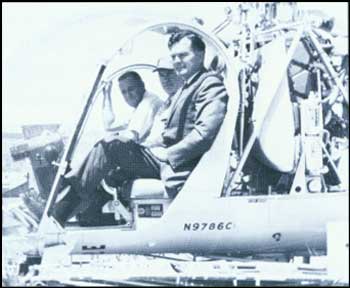
|
|
Max Lieurance (left), pilot, and Congressman Al Ullman prepare to
tour rehabilitation project. (BLM)
|
Prior to 1962, the Vale District was working through
the so-called "adjudication of grazing privileges" which in nearly every
situation produced inventory data indicating insufficient available
livestock forage for existing licensed use. The inventories were
extensive and the funding capability of BLM was such that it was
virtually impossible to explore improved management alternatives which
would deal with improving the rangeland ecosystem to any practical
degree. The result was years of litigation over grazing reductions
which, by themselves, would solve few problems; the waste of resources
in endless legal controversy; the inability of BLM managers to apply
their technical skills because of limited personnel and funding for
support projects; and, most important, the rangeland resource continued
to deteriorate while political battles raged.
The Vale project, then, was offered as a solution. A
plan was prepared by the Vale district staff which basically said "give
me the resources to work with and I can turn the program around in short
order (originally seven years). The potential is there, the technical
knowledge is there, the competent people are available in BLM, the
livestock users and other interest groups such as wildlife and
conservation organizations are more than willing to cooperate." The
support in Congress by the Oregon delegation was the key to funding and
the project was launched in 1962.
The project effort concentrated on management of the
vegetation resource for both its consumptive use by livestock and
wildlife and its non-consumptive needs for cover for a myriad of
wildlife species, soil stability, and water quality enhancement. The
project was watched closely (even nervously by some) over a period of
years and to everyone's relief (even surprise) has been judged a
resounding success. Independent technical evaluations in 1975 and again
in 1985 have confirmed its success.
The project has received international recognition as
a model of large-scale rangeland rehabilitation through intensive
management coupled with facilitating improvement. Its continuing value
for demonstration and education remains virtually untapped.
|
|
|
Hearings were held throughout the West by the Senate
Public Land Subcommittee under Senator Alan Bible of Nevada. Karl
Landstrom overheard a person testify that "nothing delights the heart of
a Nevada cowpoke more than to smell the hide of a BLM director roasting
over a sagebrush fire." Despite strong opposition from ranchers, the
Secretary adopted the 150 percent factor in 1963, which continued until
a new grazing fee formula was developed in 1968. During this period
grazing fees on BLM lands increased from 19 cents to 33 cents per
AUM.
BLM Grazing Fees
1961-1970 |
| Years | Animal Unit Month Fee |
| 1961-1962 | .19 |
| 1963-1965 | .30 |
| 1966-1968 | .33 |
| 1969-1970 | .44 |
|
|

|
|
Grazing revenues 1961-1970
|
|
|
Critics of BLM and Forest Service range programs
continued to assert that the government was not receiving fair market
value for grazing on the public lands. In 1966, the BLM and Forest
Service contracted with the Department of Agriculture's Statistical
Reporting Service to collect and study data on all aspects of the
livestock industry to estimate fair market grazing values on public
lands. The "Western Livestock Grazing Survey" included the mailing of
14,000 questionnaires, plus 10,000 personal interviews, to gather its
data.
In 1968 an interagency grazing fee technical
committee met to analyze the information. The committee needed to determine if
there was any statistical difference between grazing costs on
Forest Service and BLM lands and if there was any basis for a variable
fee. The differences, adjusted for seasons of use and other uses made of
the lands, proved insignificant. The committee set an average fair
market value of grazing at $1.23 per AUM for both agencies and
recommended that this amount be adopted as a fee for both cattle and
sheep.
Lawsuits against the proposed increases failed, but
Congress decided against implementing such large increases in one fell
swoop. Because grazing fees were then 33 cents per AUM for BLM lands and
72 cents for Forest Service lands, Congress authorized the increased
fees to be phased in over a 10-year period (9 cents a year for BLM and
7.2 cents for the Forest Service).
|
|
|
FIRE
|
|
|
BLM continued to look at fire as one of the principal
enemies of the nation's range, forest, and watershed resources. Under
Karl Landstrom, fire training for BLM employees increased. BLM
recognized that it had insufficient ground detection facilities;
construction of fire lookouts became a priority in some parts of the
West. In others, BLM began assigning "per diem fire guards" in advance
of the fire season. Fire detection flights were made after lightning
storms or during fire danger periods in many BLM districts.
As for its firefighters, BLM liked small mobile
crews. BLM relied more and more on helicopters to transport crews and
drop borate/water mixtures on fires. A Bureauwide firefighting build-up
was prompted by the 1961 fire season. Oregon, Idaho, Nevada, and Montana
all faced serious fires in July and August. A shortage of crews caused
intense competition for fire personnel; the National Guard was called to
assist with transportation and other nonfire duties.
In 1964 lightning near Elko, Nevada started several
fires: soon 300,000 acres were aflame. BLM resources were inadequate, so
the District Manager asked for help through cooperative firefighting
agreements with the Forest Service and the state. More than 2,500
firefighters, 64 aircraft, and 280 vehicles poured in from other states.
A temporary coordinating and dispatch center, the Western Fire
Coordinating Center, was established in Salt Lake City on August 18.
After the 1964 fire season, BLM strengthened its
firefighting capabilities by establishing the Great Basin Fire Center in
Boise, Idaho, on April 1, 1965—a permanent version of the earlier
coordination center. Roger Robinson, former chief of the Alaska fire
organization, was put in charge.
Robinson wanted to integrate BLM's firefighting
efforts on a national level by making the Great Basin Fire Center a
national communications, dispatch, and support center. The center's
value to the Bureau was soon demonstrated. In 1967 more than 5,000 fires
broke out in the Pacific Northwest and northern Rockies. BLM coordinated
deployments of as many as 7,000 firefighters on the line, prompting
Secretary Udall to praise the advantages of interagency cooperation in
controlling forest and range fires. The Forest Service joined BLM at the
center in 1969 when it moved into new facilities and was renamed the
Boise Interagency Fire Center.
|
|
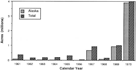
|
|
Public lands burned 1961-1970
|
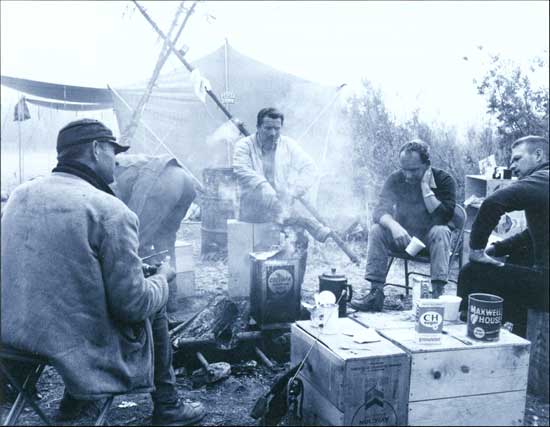
|
|
BLM firefighters on break from West Fork fire, Taylor Highway, Alaska
1966 (BLM)
|
|
THE BOISE INTERAGENCY FIRE CENTER
by Jack Wilson
Director, Boise Interagency Fire Center
The basic idea for a centralized fire support center
came from several sources. Probably the first was in a Boise National
Forest study by Deputy Regional Forester William D. Hurst in early 1961.
The Honeywell task force in April 1964 proposed a fire center similar to
Alaska's: a single fire program and center for the West. What
really forced the issue were two events. First the Forest Service and
BLM in Boise each established retardant plant operations on the same
airfield; second, large fires were occurring in BLM's Elko (Nevada)
District. The need for coordination and cooperation became painfully
apparent.
On April 1, 1965, the Great Basin Fire Center was
authorized by BLM at Boise, Idaho, and Roger R. Robinson, State Director of Alaska was sworn
in as its first Director.
Initially the Boise National Forest attached their
Fire Control Officer to the center along with their fire warehouse
personnel. Subsequently the Fire Weather Forecaster of the National
Weather Bureau joined the group. These original players drafted the
first agreement for operating the center in 1969 when the first
buildings were dedicated. There was understandably a lot of controversy
and turf fighting, but in 1972 the first overall agreement was signed,
assigning responsibility to the fire center. The Boise National Forest
moved their smokejumpers there, and BLM began building its staff. At
this time, the name was changed to the Boise Interagency Fire Center
(BIFC).
In 1973, the Forest Service elevated its posture to
the national level with the assignment of their Assistant Director for
Suppression, Bob Bjornsen, to BIFC. Bob Robinson had retired, and the
new BLM Director, Jack Wilson, was assigned. An era of cooperation was
ushered in. In 1974 the National Park Service assigned John Bowdler to
Boise as a partner at BIFC. In late 1975, with the passage of
legislation that updated the old Clark-McNary Fire protection laws, the
mission of the center became nationwide. The so-called State and Private
Forestry Law authorized states to request fire support from federal
sources.
The Bureau of Indian Affairs was added to the
agencies who are BIFC partners in June of 1977. The Fish and Wildlife Service joined the center
in October 1979.
The Office of Aircraft Services (OAS), an
organization of the Department of the Interior, was created in 1973, and
their first Director, James W. Thurston, wanted to establish his
headquarters at Boise because of the closeness of fire/aviation
relationships. So, as of 1974, OAS has resided at BIFC and shared the
costs. The Forest Service moved their aviation coordination and support
unit to Boise in 1975.
The first experience with International Fire support
came in the summer of 1976 when the provinces of Ontario and Quebec had
extreme fire seasons. This led to a joint Diplomatic Exchange Agreement
that authorized mutual fire support, and the agreement has been used by
both countries many times since it was signed in 1982.
|
|
|
FORESTRY
|
|
|
BLM stepped up its hiring of foresters in the early
1960s to manage public domain forests and woodlands outside Oregon and
Alaska, including 5 million acres capable of producing timber in
commercial quantities. Ponderosa and lodgepole pine forests in Colorado
and Wyoming were made available to lumber companies when they shut down
operations on Forest Service lands in the winter.
|
|
|
BLM's management of the O&C lands was sorely
tested in the 1960s. Cataclysmic storms, fires, and
floods challenged the Bureau's ability to
respond. Allowable cut limits
were manipulated to respond to these
situations and to the region's economic conditions, but
were finally stabilized in 1970.
|
|
O&C Lands:
In Search of
Stability |
|
BLM sold over a billion board feet of timber from the
O&C lands for the first time in 1960, taking in $34 million. Under
Secretary Udall, BLM began a study of its forest holdings and their
management. The review was interrupted by a recession that dropped
timber prices from $32 to $25 per thousand board feet; in 1962 BLM
raised the allowable cut for O&C lands to 1,127 million board
feet.
But then came the Columbus Day storm: in one day 5
billion board feet of prime timber was blown down in Washington and
Oregon; 1.5 billion board feet of timber on the O&C lands was killed
or damaged. Congress authorized emergency road construction while BLM
and the Forest Service developed a plan to salvage the timber by May
1964. BLM conferred with federal, state, and local governments and
timber companies to adjust the terms and tenures of previously issued
contracts to facilitate the process.
This massive, historic effort was completed on
schedule, but in December 1964, BLM had to deal with floods that damaged
access to $20 million of O&C timber. Congress responded with $14.8
million for emergency road repairs.
In August 1966, BLM had to cope with the Oxbow fire
in the Coos Bay District. The fire burned over 43,000 acres of Douglas
fir forest and cost BLM $900,000 (75,000 work hours) to put out. BLM
offered 180 million board feet of timber for salvage by July 1967; the
increase in sales for the Smith River Management Unit amounted to 330
percent, but all timber was harvested by the end of 1969.
|
|
|
Once Secretary Udall approved BLM's increase in
allowable cuts, he asked Assistant Secretary John Carver to continue
BLM's review of O&C policies. While this took place,
Congress passed the Point Reyes National Seashore Act in 1962, which
authorized exchanges of private lands inside the park boundary for BLM
lands in adjacent states to consolidate National Park Service holdings.
Alfred Sweet owned land inside Point Reyes and was willing to trade it
for 2,360 acres of BLM forest lands in Curry County, Oregon. A similar
swap in California fell through in 1961, because of disagreements among
BLM and Park Service land appraisers on the values of lands to be
exchanged.
|
|
Sweet Swap |
|
In 1964 Charles Stoddard asked Oregon State Director
Russ Getty to compile a list of non-O&C public domain lands in
western Oregon (totaling 240,000 acres in small tracts) that could be
used for exchange. Getty responded by listing almost all public domain
lands in western Oregon for retention because, starting in 1961, they
were included in BLM's calculations of allowable cut. BLM's Washington
Office then identified several tracts for potential exchange with Mr.
Sweet.
When word of this proposal became known, a nationwide
controversy erupted which forced its cancellation. Legislators, the
timber industry, and the Sierra Club objected to the "Sweet Swap" as a
raid on O&C lands, while other groups supported the exchange as a
good example of blocking up federal holdings. The upshot of this
episode, however, is that both Stoddard and Getty lost their jobs (they
declined to accept new positions), and Secretary Udall suspended all
other Park Service-BLM exchanges.
Despite this incident, BLM continued its review of
O&C forest management and concluded that its productivity must be
balanced with environmental quality. Of BLM's total O&C holdings,
108,000 acres were found to have unstable soils and another 100,000
acres comprised valuable watersheds with soils that could be damaged by
timber harvesting. BLM therefore proposed to separate these lands, plus
72 recreation sites and 172 potential sites from the O&C allowable
cut base, along with 50,000 acres comprising valuable natural areas or
wildlife habitats.
BLM also wanted to modify harvest techniques on
150,000 acres, create 380 miles of roadside corridors, and protect 3,000
acres in scenic areas. Under Boyd L. Rasmussen, BLM proposed new timber
management techniques that included genetic improvement and
reforestation for problem areas. BLM implemented this plan in 1970,
after President Nixon directed both Interior and Agriculture to
incorporate productivity and environmental quality in new timber plans.
The new O&C management plan reduced allowable cuts from 1,323 to
1,172 million board feet and stabilized them at that level. Oregon State
Director Archie Craft and his Chief of Resources, Murl Storms, met with
the public and industry groups to explain the program and assure them of
the its long-term benefits.
|
|
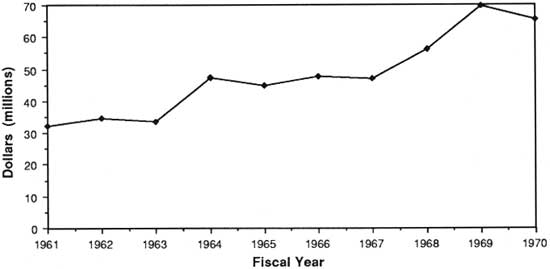
|
|
Timber revenues 1961-1970
|
|
|
WILD HORSES AND BURROS
|
|
|
The treatment of wild horses and burros on the public lands emerged as a
major national issue in the 1960s. By the end of the decade, BLM
received more mail about horses than all other topics combined. Accurate or not,
wild horses and burros came to be seen as a national
legacy, running wild and free in the West since the Spanish first
visited the area. The fact that most animals were released from failed
homesteads in the 1920s and 1930s didn't matter. BLM employees arguing
this point or stressing the need to manage horse and burro populations against the needs of wildlife
and cattle on the range were seen as proof of BLM's bias in favor of
livestock grazing.
|
|
|
THE BIG BLOW
by Larry L. Woodard
New Mexico State Director
Coastal winds in the timber-growing country of
western Oregon are regular occurrences. O&C foresters tend to ignore
such happenings until limbs start falling (time to pack up and leave) or
when your tin hat blows off (run like hell!). However, winds of typhoon
or cyclone level are very rare and until October 12, 1962, the patchwork
clearcuts of the Oregon coastal areas and Cascades had not experienced
such winds for over 100 years. Instead of the winds blowing fiercely
over the tops of unbroken verdant forests, the clearcutting of western
Oregon offered a thousand unprotected flanks of shallow-rooted conifers
to the "Big Blow" of 1962.
Meteorologists later described the sudden low
pressure trough which moved ashore on Columbus Day as one of the most
dramatic barometric changes in Oregon history. In our Harvard Avenue
office in Roseburg, most of my staff was in the field when the winds
began to pick up. By midafternoon the wind was pounding the old
storefront windows and after a few false starts, the lights went out for
good. Debris was blowing down the street and power lines began to break
as limbs and trees started falling.
The office closed early. I drove through the Veterans
Hospital grounds, around fallen trees, and found my family gazing out
the front room window watching the neighbor's carport cartwheel down the
street. Composition shingles were flying around the neighborhood and it
was not until the next morning that I was able to account for all my
employees. One of my foresters, John Rice, reported later that they had
left surveying equipment in the field when the wind hit and had barely
made it out to the highway. A flight the next day showed over 100 trees
across their escape route. By early evening the storm had passed and the
neighborhood gathered in the streets to look at the damage.
The entire District assembled the next morning
because Rod Fety, Timber Management Branch Chief in the Oregon State
Office, and his staff were already asking for early damage estimates.
Foresters fanned out over the District with maps to plot the blowdown
areas. By the end of the first day, my staff reported that the blowdown
was so extensive that ground surveys were impractical. The next morning
Sam Heaney, Drain Area Manager, and I took a helicopter flight from
Roseburg to Drain and then back to Glide, Oregon. Sam quickly gave up
trying to map the blowdown on an ungainly map that covered the whole
cockpit, so I mapped while Sam estimated volumes. As we approached the
NE corner of each clearcut, 10-40 acres of prime old growth timber
could be seen laying on the ground in a jack-straw pattern.
That afternoon, we reassembled in District Manager
Archie Craft's office to report our damage estimates. My counterpart was Jim Richardson
(South Umpqua Area Manager); I noticed that when he gave his estimate he had
substantially increased his figures. Suspecting that he was trying to
position himself for expected additional funding, I doubled my estimate.
Sam glared at me with his one good eye; as it turned out even our
inflated estimates were both 50 percent too low.
An immediate request for additional funds went
forward and the Secretarial Regulations were waived to allow for
contract extensions, scale sales, and adjustment of existing timber
sales. Everybody began a 6-day-a-week work schedule and within 8 months
much of the timber was placed on the market. Every forester became a
timber cruiser and truckloads of marking paint made the Nelson Paint
Company a household word in the Northwest. We let the timber industry
know we had added tracer elements to the BLM paint to minimize timber
theft.
My recollection of the entire blow down salvage
operations was one of tremendous individual and agency pride in our
accomplishments. New road construction was dramatically accelerated,
and by the end of the effort, access to almost all of the O&C
timberlands was complete.
Estimates of the timber loss in western Oregon were
2.5 billion board feet, of which half was on the O&C lands. By the
end of FY 1963, the O&C staff had offered 926 million board feet of
the estimated 1.25 billion board feet of wind blown salvage. Typical of
the western Oregon situation in 1963, the Roseburg allowable cut was 187
MMBF, but we had offered 256 MMBF. A remarkable accomplishment!
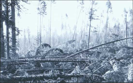
(BLM)
|
|
BLM'S FIRST "LADY" FORESTER
by Edwin Zaidlicz
Former Montana State Director
Editor's Note: BLM's resource programs were male-dominated
domains until the 1960's. In only two decades, however, women became an
integral part of the Bureau's resource management programs. Women professionals
are now found in all programs and a number have moved into decision making
professions. In hiring women professionals, the forestry program led the
way. The first women forester in BLM was Elaine (Mosher) Pearsons.
In the two accompanying stories we have the reaction of a long-time
BLM forester to the hiring of Elaine Pearson and then her own reminscence
of being a trail "blazer."

Elaine (Mosher) Pearsons (Edwin Zaidlicz)
|
Forestry in BLM was considered a domain peopled by
virile, macho-type males not gifted with attributes of gentility, subtlety
or other finer sensibilities. The few women in our ranks were saints—highly
competent, intensely dedicated and courageously loyal to the cause of the
"strange breed of cats." But none were foresters!
In 1961 several of our top headquarters' foresters
were sent to our leading forestry school to recruit. We only had a
few vacancies and great concern was shared by all—to snare the
best young grads.
Fran Jacquemin returned to report glowingly of the
"prize" he had committed from Michigan. While he ticked off his young
forester's abilities, I shared his self-serving delight until he used the
singular pronoun "she." I must admit to a feeling of shock, consternation,
and disbelief. Our proud male domain was breached, we had our first "lady
forester."
My worst fears were confirmed when Elaine Mosher nervously
reported to my office for work. I had secretly hoped that she would be about
6 fee tall, gap-toothed, with a broken nose and wearing well worn "corks" [cleated boots]. Instead, I faced a
petite, pretty, soft-spoken little lady. She was unlike any forester I
had ever met. Over time, my parochial mindset like so many of my other
firm convictions suffered a reversal. Elaine turned out to be a jewel
and a great credit to her profession and organization. What she lacked
in size and conventional stereotyping, she more than made up for with
tenacity, awesome drive, courage and infectious adaptability.
Years after, Elaine was subjected to the acid test
for any forester by being assigned to timber sale contract
administration in the Salem O&C District Office. I can only imagine
the scene as a group of hard-bitten loggers gathered around the warm-up
fire for lunch when the government jeep pulled up and tiny Elaine
stepped out to confront them. From all reports she more than met the
test. I was convinced—ladies can't chew tobacco but they can wear
"corks."
|
|
TRAIL BLAZER: BLM'S FIRST WOMAN
FORESTER
by Elaine (Mosher) Pearsons
BLM Forester—Retired
My BLM career began in 1961 when I was recruited from
Michigan Technological University to work in Washington, DC. With no
other professional-level job offers, I was grateful the BLM was willing
to take a chance on me although a bit disappointed it wasn't a field
job. In retrospect, my 2 years there training under Eugene Zumwalt, Ed
"Moose" Zaidlicz and many other top foresters, better prepared me for my
following field job. In DC, we were faced with organizing the harvest of
the 1962 blowdown timber on the O&C lands.
Otto Krueger, District Manager at Salem, accepted me
as the first woman field forester. I worked under Dick Renfeldt,
Resource Manager for the East Side of the District. Dick's fine sense of
humor took this new situation in stride and he made me feel a welcome
part of the team as did most of the other foresters in the district. He
placed me with Bill Taylor who was heading the reforestation
program.
My first job with Bill was helicopter seeding. I was
to take an outdated map and an old International Carryall heavily loaded
with seed to meet Bill and the helicopter at loading points. I had never
driven a truck before, let alone a badly swaying one, nor had I been
around on any mountain logging roads. Somehow, in spite of the fear I'd
mess up, the seed got delivered and I even had a turn seeding in the
helicopter.
Messing up was always a concern as I felt I had to do
everything right being the first woman field forester. My first day in
the field with Dick, I ran a tree branch into my ear. Following that
incident, though, I had a good safety record throughout my employment
working in the field alone and traveling some scary logging roads to old
plantings and seedings.
One time I was delayed by the State Police near
Molalla. Wearing a stocking cap and work clothes, the trooper thought a 5' 2" teenage boy was
stealing a government truck.
For about 2 years I continued doing reforestation
survival surveys and when the new push for BLM recreation sites arose, I began evaluating sites
for possible development.
During the next 2 years, I was transferred to the
West Side of the District under Guy Higginson and Paul Kuhns doing much
of the same type of work and was promoted to a GS-9 as I took on more
responsibilities. Because of my knack for writing, I got in on some
analysis studies and reports. Now I was working in the Coast Range in
some of the best O&C timberlands.
By 1968, an obsession for training horses overwhelmed
good sense and ended my forestry career prematurely. Since then I've
married twice, once raising four stepchildren with a BLM timber cruiser,
Dallas Chalfant (deceased), and now freelance writing, land surveying
and owning a pack outfit with my husband, Don, for the past 11 years. We
live in North-Central Idaho where we enjoy wilderness hunting and
fishing.
|
|
|
Under the law, wild horses and burros were viewed as
feral animals, not qualifying for protection under any wildlife
legislation. BLM routinely issued permits in the 1950s and 1960s to
companies gathering horses and burros off the public lands. More than
100,000 wild horses had been captured in Nevada alone during the 1950s,
with most destined for rendering plants. In 1964 more than 1,200 animals
gathered in a single roundup in Montana were sold as bucking horses.
In the late 1950s, BLM estimated that there were
around 20,000 wild horses remaining in nine western states. By the late
'60s this estimate dropped to 17,000. Much of the public became
concerned that horse and burro numbers were dwindling and suggested the
government set up refuges for them.
In 1962, the Nevada Wild Horse Range was created
within the 394,000-acre Nellis Air Force Base. BLM built watering holes
throughout the area, and, because livestock were not permitted on the
base, wild horse numbers grew from about 200 in 1962 to more than 1,000
by 1976. Once protected, horses proved they could multiply rapidly.
The story of wild horse protection in America goes
back to 1950, to a woman named Velma Johnston. Johnston made the 20-mile
trip from her ranch outside Reno to her office for years, but one day
found herself behind a cattle truck loaded with horses. Noticing blood
dripping out of the back, she decided to follow the truck. What she
found was a load of wild horses being delivered to a rendering plant.
Most were injured, some badly, from the capture. On that day she resolved to publicize
the plight of wild horses and prevent the kind of treatment she saw.
|
|

|
|
Wild horse and burro areas on the public lands
|
|
|
In 1952, Johnston and her supporters convinced Storey
County, Nevada, to ban the use of aircraft in gathering horses. When
Congress passed the Wild Horse Protection Act of 1959, much of the
credit belonged to Johnston, who proudly took the name "Wild Horse
Annie" from her detractors. In 1965, she founded the International
Society for the Protection of Mustangs and Burros, and soon after, the
Wild Horse Organizational Assistance (WHOA). These groups and others
then began a concerted effort to convince Congress to establish a
national policy for protection of wild horses and burros, which came to
fruition in 1971.
In 1968 BLM established the Pryor Mountains Wild
Horse Range on 32,000 acres of land on the Montana-Wyoming border. The
area was created after a local dispute erupted into a national
controversy covered by the national news media.
Range conditions in the Pryor Mountains had
deteriorated to the point where most lands were in poor condition and
continuing to decline. At the same time, horse numbers had risen to
about 125. The Montana Game and Fish Department asked BLM to remove most
of the horses because they were using browse needed by deer. Several
ranchers voiced concern about declining livestock forage. BLM worked out
plans to remove all but 20 horses from the area.
Ranchers Lloyd and Royce Tillet, however, wanted to
preserve the herd. So did the Lovell, Wyoming Chamber of Commerce. Wild
horses had lived on the Tillets' lands since their parents settled there
in 1894. A nationwide letter-writing campaign in 1966-67 convinced BLM
to hold off on removing any horses pending further study of the
situation. Director Rasmussen appointed a national wild horse advisory
committee, which included Wild Horse Annie and the mayor of Lovell among
its members.
|
|

|
|
Wild horse roundup, Wyoming (BLM)
|
|
A DIRECTOR'S PERSPECTIVE:
1966-1971
by Boyd I Rasmussen
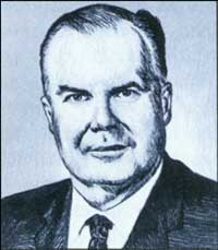
Boyd L. Rasmussen (Jennifer Reese)
|
Editor's Note: Boyd L. Rasmussen spent 31 years with the
Forest Service before becoming Director of BLM. After receiving a degree in
forestry from Oregon State University, Rasmussen served as a district ranger,
forest supervisor and Regional Forester in the Northwest. In Washington,
he worked in the Division of Fire Control and became deputy chief of
the Forest Service in 1964.
On a busy Washington day in 1966 my secretary came
rushing into my Forest Service Office saying, "There's a guy on the
phone who says he is the Secretary of Interior Stewart Udall and
he wants to talk to you." It was Secretary Udall and
he wanted to know if I was interested in becoming the Director of
BLM. Thus my BLM career began.
Without a BLM background it was necessary for me to
quickly understand its missions, objectives, legal responsibilities, and
organization. Understanding relationships with the Secretary's staff and
congressional committees was a must. At the same time it was imperative
that my leadership be established to secure the support of the BLM staff
as well as the Secretary's staff.
Foremost there was a need to secure recognition of
BLM as a professional organization both within and outside the Bureau.
It was mandatory to spearhead a PR program to secure favorable
recognition of BLM's many outstanding accomplishments. Most of my
efforts were directed with these in mind. It wasn't easy but BLM was
ready.
My first project was to bring stability, poise, peace
and quiet to a Bureau which had more than its share of unfavorable
publicity, poor judgment, secret feuds, antagonism between the
Washington and field offices, and a buddy system. I started by getting
acquainted with the Washington and field staff and determining their
capabilities. After all, they had a new Director they had never seen
before, who had never worked for BLM, and came from a rival agency. I
found the staff to be capable, professional, and eager to move. Now for
some of the Bureau's accomplishments. Grazing fees had long been a
problem for the BLM both with the permittees and the Congress. The
recently completed Grazing Fee study by FS and BLM indicated that an
increase was justified. The study did not recognize permit value as a
part of the range fee calculation and gave an opportunity to effectively
oppose any recognition of permit value.
Permit value was a rallying point for the permittees
to fight the fee increase. Political support was on both sides. After
much discussion a compromise was adopted. Grazing fees would be
increased by increments over a 10-year period. To keep the study fee
current, an inflation index factor was to be calculated annually. Thus
the grazing fee would be in two parts—the annual increment and the
inflation factor. The Secretary signed off at this point and BLM no
longer had an annual grazing fee fight.
Sustained yield figures for the O&C and Coos Bay
Wagon Grant lands had been controversial. Increased timber harvests
were under suspicion from environmental interests. Overcutting charges
were made. New studies indicated that under non-declining even flow the
sustained yield figures should be reduced. Industry opposed any
reduction in cut. Through a successful information program, BLM was able
to secure support for a reduction. However, the Governor of Oregon
entered into the discussions. Again it was necessary to reach an
agreement both sides could live with. The final result was to reduce the
allowable cut over a 4-year period. It was further agreed that the
annual cut would include salvage material. This agreement stood and one
more controversy was behind us.
The Classification and Multiple Use Act directed BLM
to classify public lands for retention and management or for disposal.
It presented an opportunity to look at all the public domain land in a
different light—multiple use and ultimate retention and management.
The decision was made to classify large areas on a broad basis. It gave
us an orderly process of presenting our findings to the public and local
officials for their approval. Consulting with local officials
took away much of the political heat. In fact some counties
conducted the hearings for BLM. Hearings allowed the public to be
heard—and public approval went a long way. BLM classification work
had a profound effect on the PLLRC recommendations.
State in lieu land grants had long been a headache and,
while apart of normal activities, were subject to available
appropriations. Our biggest problems were in Arizona where the state
land department demanded immediate action on transfer of 600,000 acres
of public domain for land inside national forest boundaries. Congress
agreed to finance a program to transfer 200,000 acres a year.
The Boise Interagency Fire Center was made
operational through continuous annual appropriation requests by BLM.
Although the Forest Service shared in the center's operation, all
development appropriations were secured through the BLM budget.
Thousands of unresolved land entry cases were on the
books. Progress in resolving them was at a standstill. New cases came
faster than decisions were made on old cases. We took our problem to the
Congress and were able to start an orderly process to reduce the
backlog.
We also launched a very successful PR program to gain
public support and understanding of BLM multiple use programs stressing
wildlife and recreation. Johnny Horizon was a first-rate PR effort to
create a better awareness of the values of the public lands and the role
of conservation.
When I left BLM it was a stable, professional outfit
working together on common goals accepted by the field and Washington
office. It was perceived by other professional groups as an equal. It
had experienced many successes and was ready for more. Its fiscal
programs were in order and its budget progress focused on performance.
Problems were faced squarely and resolved in an expeditious manner.
Personnel changes were based on merit.
BLM had public and Congressional approval. It was a
responsible, dedicated public bureau staffed by many capable men and
women who were proud of their work. I too was proud of being a part of a
great bureau.
|
|
|
Fearing a roundup was still imminent, the Humane
Society of the United States sued BLM to prevent it. Although a
preliminary injunction against a roundup was denied, the case could have
been reopened whenever BLM announced plans to gather horses from the
area.
Thousands of letters deluged the Department, from
elementary school students and their parents to concerned citizens all
over the country, asking that BLM create a refuge for the horses.
Director Rasmussen personally visited the Pryor Mountains in 1968 and
concluded that the area should be established as the Bureau's first wild
horse range. On September 12, Secretary Udall signed a Public Land Order
establishing the refuge; BLM dropped its plans to remove horses from the
area, but set a limit of 125 to 145 horses for the range to protect its
forage.
|
|
|
WILDLIFE
|
|
|
Inventories of wildlife habitat on the public lands
began in earnest after the CMU Act was passed. Public lands were found
to provide important habitats for wildlife, including an estimated 3
million big game animals. Half the salmon and steelhead trout harvested
along the Pacific Coast spawned on public lands. Eighty-five percent of
the desert bighorn sheep's habitat existed on BLM lands.
In 1961, Secretary Udall designated 60,000 acres of
BLM lands in California as the Caliente National Land and Wildlife
Management Area to develop wildlife and recreation potentials under the
authority of the Public Land Administration Act of 1960. By 1963, 14 areas in
California totalling 810,000 acres were being managed on a cooperative
basis with the state.
Also in 1961, BLM hired its first wildlife
biologist. In addition, the Bureau signed a cooperative agreement for wildlife
habitat management with the Arizona Game and Fish Department, and
proceeded to reintroduce wild turkey and antelope on public lands in the
Arizona Strip District.
After passage of the CMU Act, Bob Smith, former Chief
of the Arizona Game and Fish Department, was brought into the Washington
Office to head up BLM's newly created Wildlife Division. BLM hired
biologists in District Offices starting in 1965 and began to enter into
wildlife research projects with other agencies. BLM's first fisheries
biologists were hired in Oregon and California (in both State and
District Offices) in 1968 to work on valuable anadromous fishery streams
along the Pacific Coast.
|
|
|
WATERSHED
|
|
|
While much of Congress' legislative efforts in the
1960s focused on recreation issues and preserving special areas (e.g.,
parks and wilderness areas), it also passed three acts dealing with
water in 1965. The Water Resources Research Act allowed BLM to increase
its watershed research activities, while the Water Resources Planning
Act authorized BLM to enter into comprehensive water resource planning
with other federal and state agencies. Under the Water Quality Act, BLM
assisted western states in setting clean water standards.
A frail-lands study begun in 1965 identified 6.5
million acres of lands in the critical stages of erosion and over 38
million acres as being highly vulnerable. BLM took part in the
Department of Agriculture's National Inventory of Soil and Watershed
Conservation Needs and increased its cooperation with the Soil
Conservation Service (SCS); 168 agreements were signed with SCS
districts under Director Stoddard.
|
|
|
AID TO OTHER NATIONS
|
|
|
BLM provided assistance to 70 other nations during
the '60s. In 1964 it entered into Participating Agency Service
Agreements with the Agency for International Development, where BLM
recruited employees for overseas assignments.
BLM's biggest effort occurred in northern Nigeria,
where employees set up five range demonstration projects. Year-round
water sources were developed and the range was managed for multiple use
to improve forage and allow the nomadic Fulani Tribe to settle on the
land. BLM also worked with Brazil, Iraq, and Saudi Arabia to design land
survey systems and train them in record keeping.
|
|
|
VOLUNTEERS
|
|
|
Involving the public in BLM's classification process
did more than just increase people's understanding of the public lands.
America's rising interest in public lands translated into volunteers for
a variety of projects. Foremost were litter campaigns—Boy Scout
troops and citizens groups cleaned up recreation sites and
trails—while spelunkers helped outdoor recreation planners locate
and protect cave resources. Ranchers continued to build range
improvements and wildlife groups built watering holes for game
animals.
Johnny Horizon was created as part of a BLM
nationwide antilitter campaign in 1968, but came to symbolize a new
public land ethic in the West—one of people caring enough for their
lands to take care of them. Actor/singer Burl Ives hosted a series of
nationwide public service announcements to spread the word and did
several Earth Day/Johnny Horizon concerts. The Department soon latched
on to the campaign but disagreed as to how it should be funded; this and
the program's wider coverage caused it to lose focus, resulting in its
cancellation only 4 years after its inception.
|
|
|
NIGERIAN EXPERIENCE
by Jack Mcintosh
Former Butte District Manager
My Nigeria, Africa assignment was unquestionably the
highlight of my career, for which I returned a better employee than when
I left. The experience also had a positive impact on my family. I can
recall many small day-to-day actions in the workplace and in the home
setting where we really had a positive impact on the Nigerians. I will
also state up front the program was successful and a credit to BLM. For
our work, the team received a Departmental Unit Award which I display with
pride. In spite of this, I take greater pride in my family's performance,
which served to improve Nigerian lifestyles.
During the 1960s, the Nigerian government was structured
as it was when the British granted independence from colonial rule. The
national government was structured after the English. Under this
provincial form of government, the native government remained intact and
divided into Emirates as it had been for many years. The tax to support the Native Government was
not based on land but on livestock as it had been in pre-colonial
days.
Historically, the Fulani tribesmen, the cowboys of
Nigeria, were nomadic, moving their herds north and south with seasonal
rains, roaming from one Emirate to another as they saw fit.
Consequently, it was difficult, often impossible to inventory the herds
and harder yet to collect taxes. As a result, the Native Government had
a huge interest in "settling the Fulani." They had no dynamic force like
the IRS to collect taxes.
Since water and forage were key to the nomadic
behavior of the Fulani, it seemed simple to apply American techniques of
range management by developing water and grazing systems. The Fulani
would then be tempted to stay in one place, making it easier for the
Nigerian "IRS" to find and tax them.
So our team's objectives were two-fold: improve the
range and settle the Fulani. The government's objective was simple: collect taxes.
Without going into great detail, our team applied
systems, methods, and studies that had been successful on American
ranges. We did these things with state-of-the-art techniques and in the
end were only moderately successful. However, our plan to formally
educate selected Nigerians in the U.S. proved of long-term benefit and
was very successful.
Based on my experiences, I believe we should continue
and expand the formal education programs for key Nigerians in the U.S.
This interchange of ideas and exposure to different cultures was highly
beneficial. Furthermore, I believe that Marshall Plan techniques cannot
be duplicated in Third World nations and should not be tried. There
simply is no quick cure for elevating these nations into American
standards socially, politically, and educationally. Our effort to do so
was like turning kids loose in a candy store. In our case, we gave the
Nigerians techniques and equipment they were not capable of managing or
implementing.
We can all criticize the mistakes Americans sometimes
make when in foreign countries. Perhaps some things have changed, yet
today I see the same flaws in policy that have contributed to the U.S.
falling from grace in the international community. We have seen
embassies overrun, American officials kidnapped and misuse of foreign
aid. All are commonplace. Maybe we all need to try a little harder?
|
|
|
FROM LEGISLATION TO LITIGATION
|
|
|
By the end of the 1960s, public land management was
becoming a hotly debated topic. The public became a permanent player in
the game and demonstrated that it was no longer willing to entrust the
job entirely to land managers, to House committees, or to anyone else to
the exclusion of others. The 1960s became "years of profound questioning
and resisting of the established order," according to Dr. Sally Fairfax.
"Techniques of political activism developed in the civil rights movement
and refined in the antiwar movement were employed in the environmental
cause."
While most conservation and user groups focused their
efforts on obtaining legislation to meet their goals, others began to
look at litigation. Here, too, the times were
changing—environmental groups gained the right to sue the
government. In 1965, an organization's "standing to sue" (the right to
be heard in court) was granted by the U.S. Supreme Court to a group
suing the Federal Power Commission. In this and other cases, the court
broadened its interpretation of standing to sue from individuals
suffering economic or physical harm to groups threatened with loss of a
resource their members used. The court also found government actions to
be within its scope of review, no longer refusing to hear cases by
deferring to agency expertise.
According to Dr. Fairfax, America's conservation
movement had been defined and led by government idealists since the
early 1900s. In the 1960s, however, "the agencies were not leading the
movement; and toward the end of the decade, they were being attacked by
it."
|
|
Bureau of Land Management
1961-1970
|
| Employees |
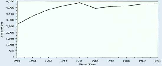 |
| Budget |
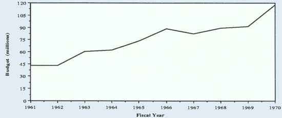 |
| Revenues |
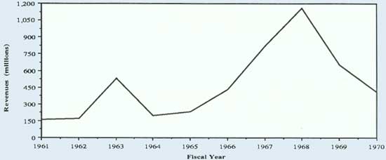 |
| Directors |
| Karl Landstrom | 1961-1963 |
| Charles Stoddard | 1963-1966 |
| Boyd Rasmussen | 1966-1971 |
|
Major
Legislation |
| Classification and Multiple Use Act | 1964 |
| Public Land Law Review Commission Act | 1964 |
| National Environmental Policy Act | 1970 |
|
|
|
|
FURTHER READINGS |
|
|
As in the 1950s, historians have given little
attention to the Bureau of Land Management. The material that is
available is the work of political scientists, economists, and natural resource
management specialists.
Samuel T. Dana and Sally K. Fairfax provide an
overview of federal land policy in the 1960s in Forest and Range
Policy: Its Development in the United States, Second Edition (1980),
that includes some discussion of BLM. Marion Clawson has some brief, but
good, discussion on BLM during these years in his The Federal Lands
Revisited (1983). The internal workings of BLM are addressed by
Marion Clawson in The Bureau of Land Management (1971) and David
Paulsen's "An Approach to Organization Analysis: A Case Study of the Bureau of Land
Management," Ph.D. dissertation, University of Washington, 1966.
Secretary of the Interior Stewart Udall's Third
Conservation Wave is discussed by Barbara Leunes in her "The
Conservation Philosophy of Stewart L. Udall, 1961-1968," Ph.D.
dissertation, Texas A&M University, 1977. Also see Stewart Udall's
The Quiet Crisis (1963).
A good compilation of articles on various aspects of
public land management is found in Public Land Policy: Proceedings of
the Western Resources Conference, Fort Collins, Colorado (1968).
Range policy for the period is lightly touched upon by William Voigt,
Jr., Public Grazing Lands: Use and Misuse by Industry and Government (1976).
On the wild horse and burro debate in the 1960s, see Heather Smith
Thomas' The Wild Horse Controversy (1979) and Wild Horses and
Sacred Cows (1985) by Richard Symanski.
The O&C lands are discussed in Elmo Richardson's
BLM's Billion-Dollar Checkerboard: Managing the O&C Lands
(1980) and The O&C Lands (1981) by the University of Oregon's Bureau
of Governmental Research and Service. The Bureau's firefighting
program is discussed by Stephen J. Pyne in Fire in America: A Cultural
History of Wildland and Rural Fire (1982).
Mineral policy and development is discussed in Robert
Swenson's "Legal Aspects of Mineral Resources Exploitation," in
Paul Wallace Gates' History of Public Land Law Development (1968),
and by Carl Mayer and George Riley in Public Domain—Private
Dominion: A History of Public Mineral Policy in America (1985). Oil shale is
handled by Chris Welles in The Elusive Bonanza: The Story of Oil Shale,
America's Richest and Most Neglected Natural Resource (1970). Robert
Nelson's The Making of Federal Coal Policy (1983) is a very good study
of the Interior Department's management of this mineral resource.
The State of Alaska's land program is expertly
detailed by Gary Stein in "Promised Land": A History of Alaska's
Selection of Its Congressional Land Grants (1987) and state
conservation initiatives in Alaska: A Challenge in Conservation
(1967) by Richard Cooley. The Alaska Native lands dispute is discussed
by David S. Case, Alaska Natives and American
Laws (1984); Mary Clay Berry, The Alaska Pipeline: The
Politics of Oil and Native Land Claims (1975); and Robert Arnold, et
al., Alaska Native Land Claims (1978).
On the Public Land Law Review Commission and its
recommendations, see the Commission's report One-Third of the
Nation's Lands (1970) and the Natural Resources Council of America's
What's Ahead for Our Public Lands? A Summary Review of the Activities and
Final Report of the Public Land Law Review Commission (1970).
|
|
chap3.htm
Last Updated: 08-Sep-2008
|