OPPORTUNITY AND CHALLENGE
The Story of BLM
|

|
|
BLM CONSOLIDATES ITS GAINS:
The 1980s
There's no pressure like multiple use pressure.
—George Turcon
|
BLM CONSOLIDATES ITS GAINS
The 1980s
|
|
|
In the 1980s, the Bureau of Land Management
consolidated the legislative gains it had made in previous decades and
implemented cooperative resource management programs with land users in
the field. A legislative mandate for multiple use management of the
public lands was in place. Now the Bureau's challenge was
to apply its authorities wisely and appropriately. According to former
Assistant Director Irving Senzel, "Adequate law facilitates effective
management, but does not guarantee it." How BLM implemented its mandates
in the field was crucial to its goal of effective land management.
|
|
Overview |
|
Director Robert F. Burford continued to decentralize
Bureau operations to the field and implemented a "good neighbor" program
intended to improve relations with local land users and state
governments. BLM streamlined its regulations, inviting land users to
increase their participation in managing the public lands. The use of
cooperative agreements was expanded to get land users actively involved
in solving resource management problems. In addition, the Bureau
expanded its use of volunteers, whose contributions in funds and labor
totalled $7.5 million in 1987. With these efforts, attempts to
privatize the public lands in the Sagebrush Rebellion came to a
close.
Although BLM transferred its responsibilities for
managing offshore minerals to the Minerals Management Service in 1982,
onshore functions were consolidated with the Bureau a year later.
Federal responsibilities for classifying onshore mineral lands,
overseeing exploration and development activities, and inspecting field
operations were consolidated for the first time. BLM began to manage
mineral resources on an equal footing with renewable resources.
The Bureau's planning system became a reliable tool
for examining land uses and resource issues together, allowing both
managers and users to participate in the decisionmaking process. While
the participants in BLM's planning process—both inside and outside
the Bureau—did not always agree on the Bureau's management
priorities, at least they came to understand the system and their roles
in it. BLM encouraged participants in the process to develop resource
partnerships in a multiple use context rather than advocating
preservation or development of separate resources.
The nation's change to an information society,
together with increasing demands on public lands and resources, provided
BLM a new challenge in the 1980s. The Bureau's rapid growth over the
last four decades included massive increases in the information it
maintained. Just managing this data and creating meaningful
summaries—for both land managers and the public—proved to be
difficult. In the 1980s, BLM recognized its data was a significant
national asset and began to develop an automated Land Information
System. The Bureau began to modernize its ADP equipment,
standardize its data, and integrate its information
systems to more efficiently process its workload and to make its
information on federal land and mineral resources more readily available
to the public.
|
|
|
Except for the transfer of 800 employees from the
Minerals Management Service in early 1983, the number of Bureau
employees remained fairly constant in the 1980s, as did its budgets. But
in some programs, budgets actually declined for the first time in 40
years. To ensure that BLM accomplished its management objectives and
fairly allocated its budgets, Director Burford strengthened the role of
BLM's Management Team in overseeing Bureauwide program development and
implementation. The "BMT," consisting of Associate Directors in
Washington, State Directors, and the Directors of the Boise Interagency
Fire Center (BIFC) and the BLM Service Center, has since played a major
role in identifying present needs and future priorities.
|
|
Bureau
Management
Team |
|
Burford also asked several veteran State Directors to
serve as Associate Directors in Washington "because people with recent
field experience are often the best advisors, especially in top
management." According to Burford, it was critical that the Bureau have
State Directors rotate to headquarters "to help whoever sits in the
Director's chair and the Assistant Secretary's office understand how
their decisions affect day-to-day management of the public lands."
|
|
|
THE SAGEBRUSH REBELLION AND REAGAN ADMINISTRATION INITIATIVES
|
|
|
In 1979, the Nevada Assembly passed a bill that
called for state control of BLM lands. Arizona, New Mexico, Utah, and
Wyoming passed similar legislation within a year. Six other western
states (California, Colorado, Idaho, Montana, Oregon, and South Dakota),
however, defeated or vetoed "Sagebrush" bills. During the 1980
Presidential campaign, Ronald Reagan said "Count me in as a Sagebrush
Rebel," but by 1981 the issue had almost disappeared.
|
|
Sagebrush
Rebellion |
|
According to historian Phillip Foss, the "good
neighbor" policy of Secretary James Watt helped defuse the rebellion.
Traditional public land users—ranchers and mineral
interests—were assured they would have a continued presence on the
public lands and be included with other interests in cooperative efforts
to develop land use plans. But the idea of privatization of federal
assets remained. In 1981, Senator Charles Percy of Illinois introduced
S.R. 231 asking the federal government to sell off excess lands and
properties to reduce the national debt. On February 25, 1982, President
Reagan issued Executive Order 12348 establishing a property review board
to identify federal assets no longer needed by the government. Included
were buildings and other "real property," plus isolated, scattered
tracts of the public lands.
|
|
|
A governmentwide "Asset Management" program was
established to dispose of these holdings. Although it was not a new idea
(disposal of scattered, isolated tracts of public land was common
in the 1950s and 1960s), the program generated a great deal of
controversy. Many agencies argued that excess properties identified
under the program might be needed under federal ownership in the future.
Conservation groups distrusted the Interior Department's motives in
disposing of federal lands and criticized what they perceived as the
program's broad scope. Most BLM land users, when confronted with the
prospect of purchasing land at fair market value, found they preferred
that the lands remain in public ownership.
|
|
Asset
Management |
|
Since the Asset Management program never generated
broad support from the public and was not tied to ongoing Bureau
initiatives—such as BLM land exchange programs—the effort was
abandoned during President Reagan's first term in office. The idea of
forming more logical management units on the ground, however, found
widespread support; BLM's land exchanges grew in importance.
|
|
|
A STATE DIRECTOR'S PERSPECTIVE
by Clair M. Whitlock
Former State Director, Arizona and Idaho
Clair M. Whitlock (Jennifer Reese)
|
Looking back at my 32 years with the Bureau of Land
Management, I am impressed with the ever-changing patterns or mosaics
of activities which make BLM a unique organization. These mosaics are
really problems and opportunities bound together by a rich history,
politics, the law, and the traditional can-do attitude of BLM's people.
The Bureau's problems and opportunities consist of its
basic mission as prescribed by law and regulation, overlaid by initiatives
of the current administration or some outside entity. Perhaps State Directors'
most significant role is to provide an interface between field workers and the
politicos, inside Interior as well as user groups or the public at large.
The first half of the 1980s had a pattern that was different
but typical in complexity of most any 5-year period in BLM's history. Traditional
work levels and complexities were affected by administration initiatives such as
Asset Management (sale of public land to reduce the national debt), the BLM/FS
Interchange, and searches for ways to increase ranchers' active participation in
managing the range resource. Conveyance of in-lieu selections to the states
was pushed to high visibility by state governments and concurred in by both the
Carter and Reagan Administrations.
Occupancy trespass abatement on the Lower Colorado River was
a priority job dating from the 1960s. It was just wrapping up during the transition
from Carter to Reagan. Wilderness study was a new program mandated by FLPMA which
had drastically different directions under the two administrations. My role as
State Director in this political interface was two-fold: First, legitimize
administration initiatives and policies with the field personnel who
already had more work than time; second, to report
problems and suggestions to the policy makers to help smooth the process.
For example, the Asset Management program seemed to
fly in the face of FLPMA. which in general prescribed long-term federal
ownership of the land. I helped employees understand why the program was
being advanced—that it was a White House initiative and that we
would proceed per instructions. I also provided feedback to the
administration on the lack of local interest (and dollars) to buy the
lands, and other impacts. In Idaho this was so volatile an issue that
several state and county officials used it as an election issue. Asset
Management ran its course, but not without diverting much time and money
from traditional realty programs.
The Lower Colorado occupancy abatement program was
given high priority through several administrations. My involvement with
the program came when the last trespasses were to be settled and the
land vacated. The event came at the transition into a new administration
whose policies shifted to selling some tracts or legitimizing occupancy.
I needed to sell field managers on establishing a few lifetime estates
for hardship cases and convince the administration to return the balance
of the tracts to public use.
Keeping BLM's priority work on schedule is a
balancing act between traditional and legislatively-mandated work,
interfaced with politically-motivated programs. Helping field workers
understand that both are legitimate—and politicos to understand
local impacts and situations—gave me a lot of satisfaction.
As members of the Bureau Management Team, State
Directors can influence a wide range of policy and operational issues. I
had the opportunity to present my own ideas and suggestions on
developing employees to help them reach their potential as either
managers or technical specialists. With the help of many people, I was
able to give new direction to the Bureau training program by developing
the Careers Program.
It has been gratifying to work with the motivated and
dedicated career workers of BLM— to see them produce in the face of
great odds and in a small way help them develop into BLM's leaders of
tomorrow.
|
|
|
Consolidating federal land ownership and management
among agencies has been a recurring theme on the public lands. When
President Carter's proposal for creating a Department of Natural
Resources was abandoned, the BLM and Forest Service in May 1980 proposed
a "Jurisdictional Transfer Program" to consolidate their lands into
larger blocks, with the goal of reducing management costs, increasing
management efficiency, and improving service to the public. The program
continued through the change in administration, and in 1982 preliminary
estimates indicated that the program would save the government about $30
million a year.
|
|
BLM-Forest
Service
Interchange |
|
HISTORY OF BLM LAND EXCHANGES IN
ARIZONA
by D. Dean Bibles
Arizona State Director
In 1982, BLM was confronted with a need to satisfy
the land claims of several parties. Under the Navajo-Hopi Relocation Act
of 1980, BLM lands were to be exchanged for private lands, on behalf of
the Indians. The state of Arizona had 194,000 acres in statehood land
grants still outstanding. BLM was responsible for reimbursing the State
of Arizona for lands taken by the Bureau of Reclamation to construct the
Central Arizona Project—a canal to transport water from the
Colorado River to the cities of Phoenix and Tucson.
On top of all this, the hodgepodge of land patterns
that had developed over the years with federal, state and private lands
intermixed, had created a land manager's nightmare, making the lands
difficult to manage for their wildlife, recreation, wilderness,
cultural, economic and other values.
BLM Arizona's solution to these problems was an
aggressive land tenure adjustment program. This allowed federal and
state agencies and private landowners to block up parcel of land,
obtain other parcels for special purposes and switch administration of
still other parcels for logical management patterns.
Between 1984 and mid-1988 more than 1,700,000 acres
had been exchanged, transferred, or undergone changes of
administration, and more changes of tenure were in the works. One
example of the value of these exchanges was the acquisition by BLM in
1986 of the San Pedro River corridor in Southeastern Arizona. The San
Pedro area is one of the most significant remaining large broadleaf
riparian areas left in Arizona. It contains hundreds of wildlife species
and more than 120 known archaeological sites. Also located in the area
is a 200-yea old Spanish presidio or military fort—the only one of
its kind still in a natural setting.
Most of the San Pedro River area acquired by BLM was
comprised of two Spanish land grant dating from 1827. Tenneco West bought
the lands in 1971, and by the early 1980s wanted to dispose of them.
There were strong feelings among environmental groups and others,
however, about protecting the area from housing developments. And we in
BLM saw an opportunity to acquire and preserve this prime resource for
the American public. White Tanks Associates, a Phoenix private land
developer, purchased the lands from Tenneco. Then, in exchange for the
43,000-acre San Pedro River properties, White Tanks Associates receive
40,947 acres of undeveloped public land west of Phoenix.
Advantages of the Bureau's land exchange program
include more efficient land management—wildlife values were
enhanced, cultural resources protected, recreational opportunities
increased, and educational and research opportunities were furthered. At
the same time, land was provided for the state's economic growth without
compromising other land management goals. With more and more demands on
our public lands, Arizona's land exchange program has proved to be an
effective tool in managing for the future and allowing all agencies
involved to accomplish their goals.
|
|
|
BLM and the Forest Service could not agree on the
size or scope of the program, however, and in January 1983 suspended
work on the program. The General Accounting Office studied the program
and recommended that the Secretaries of Agriculture and the Interior
"resolve the disagreement so that the program can be resumed." In addition, the
General Accounting Office found that the agencies' efforts to comply
with the Asset Management program also hindered the transfer program by
"diverting many needed field resources" from its implementation.
In February 1986, BLM and the Forest Service issued a
"BLM/FS Interchange" proposal that would have transferred more than 24
million acres of land between the agencies and given minerals management
authority to the Forest Service for its area of jurisdiction. The Reagan
administration submitted a bill to Congress, the Federal Lands
Administration Act of 1986. In their legislative proposal, BLM and the
Forest Service reported that there were 71 towns throughout the West in
which both maintained offices. After the Interchange, that figure would
have dropped to 36 towns—each of the 71 towns would have retained
at least one of the two offices. Concern and some distrust from user
groups and the public, however—all of whom were at least
comfortable with the status quo—combined to prevent the bill's
passage as of September 1988.
|
|
| BLM/Forest Service Interchange Summary |
| (Areas in millions of acres) |
Surface Management | Subsurface Management |
| BLM | Forest Service |
BLM | Forest Service |
| Before Interchange | 177.1 | 168.7 | 420 | 0 |
| After Interchange | 171.7 | 174.1 | 216 | 204 |
| Net Change | - 5.4 | + 5.4 | — | — |
Note: Acres that would transfer from BLM to FS - 14.8 million
Acres that would transfer from FS to BLM - 9.4 million |
|
|
MINERALS
|
|
|
On December 3, 1982, Interior Secretary James Watt
transferred onshore minerals responsibilities of the Minerals Management
Service (MMS) to BLM. Earlier that year (in February 1982), BLM's
offshore mineral operations were moved to MMS when Watt moved the
Conservation Division out of the U.S. Geological Survey. Consolidation
of minerals functions in the Department had been discussed for many
years— going back to the early 1960s—with support steadily
growing for such a proposal.
|
|
BLM-MMS
Merger |
|
The Conservation Division was formed in the U.S.
Geological Survey (USGS) in 1925 to lease minerals, inspect field
operations, and collect royalties on federal lands. BLM managed surface
resources on the public lands and could veto USGS leasing actions if it
felt sensitive resources were endangered by exploration or development.
A major reason for changing this arrangement was that when BLM and the
Conservation Division didn't agree on mineral leasing, the issues were
taken up by different Assistant Secretaries in the Department, who
raised problem cases to the Secretary for final decisions. In addition,
the minerals industry had to deal with two agencies during leasing and
development. As a result, it was not an established client of either
agency, the way renewable resource interests were in BLM.
Specific proposals to merge the Conservation Division
with BLM were made under President Nixon (in the Department of the
Environment and Natural Resources) and again under President Carter. A
major reason for the failure of these proposals was their scope:
inclusion of a BLM-Forest Service merger in each proposal brought up numerous
other issues. In addition, Congress didn't like the idea of being
reorganized by the Executive Branch—these proposals would have
required Congress to rearrange its committees on Interior and
Agriculture.
When the Reagan administration's transition team
studied the merger issue, it was well aware of the potential
benefits—and fate—of previous proposals. Under Secretary Watt,
the Interior Department decided to limit any merger proposals to
"in-house" measures. Discussion first centered on whether BLM should
gain minerals duties from USGS or whether the Conservation Division
should be elevated to an independent agency.
|
|
|
THE DIFFERENCES BETWEEN BLM AND THE FOREST SERVICE
by Dr. Sally K. Fairfax
University of California - Berkeley
Editor's Note: We have asked a well-known and highly
respected "outsider" to provide her perspective of BLM. Dr. Fairfax has authored several
articles and books dealing with public land policy including Forest
and Range Policy with Samuel Trask Dana.
The similarities between the BLM and the Forest
Service are obvious and important. Both agencies are planning-oriented,
multiple use talking government land managers that are responsible for
enormous amounts of federally owned land, most significantly in the
western United States. That, plus the fact that both are part of the
federal bureaucracy suggests that these two are, if not Tweedle Dee and
Tweedle Dum, at least basically alike. Nevertheless, overstating the
similarities conceals much that is important about the land, the
managers, and the legal/institutional context that is critical.
The BLM is frequently lampooned as the Bureau of
Livestock and Mining while the Forest Service, for all its recent
embattlement continues to enjoy public esteem symbolized by Smokey
Bear's avuncular embrace. This is simply the downside of the fact that
the BLM has, for diverse reasons, always been more responsive to its
local, commodity oriented constituents. In part this reflects reality;
until recently it had no other constituents and no authority to meet
others' demands.
But the familiar tale that the Forest Service manages
the trees and the BLM manages the grass is not only not true, it
obscures the fundamental difference in the resources managed by the two
agencies. The National Forests generally came to the agency
unencumbered, reserved from the public domain prior to occupancy. The
BLM, on the other hand, manages land which had a long history of private
use prior to the belated assertion of federal authority in the 1930s.
Further, the Taylor Grazing Act dedicated the lands to a single,
specific use—grazing. Note the difference—the National Forests
are not called National Timber Lands. And the courts did not
help—it was not until the 1960s that grazing permits were
consistently recognized as a privilege which the BLM could modify,
rather than a right. The result of this distinction in the origin of the
lands is that the Forest Service has been able to manage "its" lands and
resources while the BLM has been obliged to conserve what the livestock
operators consider their lands by trying to regulate the private
ranching practices of the permittees.
That necessity, and provisions specifically added to
the Taylor Grazing Act, resulted in a significantly different labor
force in the BLM and the Forest Service. While the Forest Service was
drawing its employees from forestry schools newly developed to imbue
their graduates with the zeal of Pinchot's professionalism and several
hundred years of European experience and study in forest management, the
BLM was required to hire ranchers from the state in which they were to be
working. The orientation toward local operators was intensified by the
"McCarran leaves" in the early 1950s. Congress cut the Bureau's budget
to near zero and most BLM employees either lost their jobs or were paid
by the local Grazing Advisory Boards who, as a matter of law, were
consulted on policy. The intellectual and professional cachet of
forestry have yet to be experienced in the scholarship and practice of
range science.
This responsiveness to local political forces has
also been potentiated by the structure of the BLM, which is basically a
western operation organized on a state-by-state basis to maximize the
influence of the state congressional delegation in BLM matters. This
compares with the Forest Service's early and successful efforts to
obtain sufficient eastern land to become a truly "national"
organization, thus minimizing western domination, and its regional
organization, which puts mid-level management beyond direct reach of the
states' congressional delegation.
In spite of these severe handicaps, the BLM has long
yearned to be as respected and powerful as Smokey's boys across town. It
was, indeed, BLM advocacy and aspirations which led in 1976 to the
passage of FLPMA. Although FLPMA specifically did not repeal the Taylor
Grazing Act (a much ignored fact which speaks political volumes even if
its legal import is as yet ill-defined), it finally gave the Bureau a
firm and continuing basis for existing, comprehensive real estate
management authority, and the go-ahead for diverse multiple use
management programs which it had been fabricating for nearly two
decades.
The Reagan years were not conducive to rapid
expansion in public appreciation of the Bureau. Nevertheless, underneath
the continuing problems due to inadequate resources (one wag observed in
the early 1980s that the BLM has four times the land to manage with one
seventh the personnel and one third the money) there have been solid
gains which bode well for the future flowering of the promise of FLPMA.
For all of the reasons discussed above, the Bureau is way out front in
the current trend to involve private enterprise in public resource
management. It remains to be seen whether they can turn that necessity
into a virtue.
|
|
|
In February 1982, Secretary Watt removed the
Conservation Division from USGS, establishing the Minerals Management
Service. On December 3, 1982, onshore minerals functions (managed by 800
MMS employees) were transferred to BLM under Secretarial Order No.
3087—leaving MMS responsible for royalty management and offshore
mineral leasing. Section 5 of the order states that "all functions
related to royalty and mineral revenue management, including collection
and distribution, within the Bureau of Land Management (BLM) are the
responsibility of the MMS. All MMS onshore minerals management functions
on non-Indian lands, including resource evaluation, approval of drilling
permits and mining or production plans, inspection and enforcement, are
transferred to the BLM." The order was amended on February 7, 1983, to
add onshore Indian lands to the Bureau's responsibilities.
|
|
Minerals
Management
Service |
|
Secretary Watt intended his action to ensure "full
consideration" of mineral resources in accordance with BLM's multiple
use mandate, adding that "BLM has long-established expertise in
resolving potential conflicts among legitimate but competing interests
in onshore resource management." With the merger, minerals were placed
on an equal footing with other public land resources.
|
|
|
Since 1981, BLM State Offices signed cooperative
agreements with seven western states (Washington, Oregon, Idaho,
California, Colorado, Wyoming, and Montana) to create a single point of
contact for approving mining operations and to create joint inspection
and compliance programs. BLM also issued regulations requiring miners to
submit mining notices and develop plans of operation to protect other
resources. From 1981 to 1987, BLM patented 497 mining claims and
completed more than 8,500 mineral materials contract sales.
|
|
Mining Law |
|
Section 314 of FLPMA required that all mining claims
on federal lands be recorded within 3 years of passage of the
Act—by October 1979. As of July 1988 over 1.2 million claims
remained active, but an equal number were abandoned by failure to file
or failure to complete necessary assessment work, thereby clearing the
lands and mineral estate for other purposes, including conveyance or
exchange. According to Andy Senti, Realty Specialist in the Colorado
State Office, "FLPMA's recordation requirement was a big plus for BLM as
it provided immediate information about a resource use on the public
lands that previously was very difficult to search from county
records."
|
|
|
Under Director Burford, BLM reaffirmed the need for a
coal leasing program but changed its emphasis from meeting production
goals to leasing the amount of coal necessary to create a competitive
market. From 1981 to 1987, BLM issued 101 competitive coal leases on
federal lands.
|
|
Coal |
|
But coal development remained as controversial as
ever in the 1980s. In January 1981, 11,282 acres of coal lands were put
up for competitive bid in Colorado and Wyoming; other sales followed in
April and October. In a lease sale held in the Powder River area of
Montana and Wyoming in April 1982, charges were made that BLM's minimum
acceptable bids for leases had been leaked to some of the participating
coal companies. A coalition of environmental groups brought suit against the
Department charging that inadequate activity planning had taken place
and that fair market value was not attained in the lease sale. In
addition, prior to the sale the Northern Cheyenne Tribe in Montana sued
the Department, alleging BLM's environmental impact statement did not
address the impacts of coal development on its reservation.
|
|
|
THE LEAD MINES OF MISSOURI
by Charlie Most, Public Affairs Officer
Eastern States Office
If the battery starts your car on a frosty morning,
or if you score a double in your next round of skeet, or just use a lead
sinker to get some bait down to where the fish are, maybe you should
thank BLM. That's because 90 percent of the nation's lead supply comes
from a few deep mines in the Mark Twain National Forest in southeastern
Missouri. And since this is acquired land with federal minerals, the
Bureau's Eastern States Office handles the leasing and operational
aspects for this unique mining effort.
Lead is vital to our quality of life. Besides
batteries, shotshells, and fishing sinkers, lead is used for radiation
shields on atomic-powered submarines and energy facilities; electrical,
optical and telephone cables; plumbing; and many other items. Lead even
serves as a "cushion" around foundation pillars on skyscrapers to
protect them from tremors or shocks.
Lead has been a valued mineral throughout much of
history. In 1701 the French, during their early explorations of the
Mississippi Valley, found lead ore in southeast Missouri. By 1720 the
LaMotte mine, in what is now Madison County, was in operation. During
the late 1700s, shallow lead deposits were also being worked near
Potosi, and in the early 1800s, additional nearby lead deposits were
developed. This area, centered about 80 miles south of St. Louis, became
known as the "Old Lead Belt" and production continued there until
1972.
But with signs that the old lead belt was being
depleted, St. Joseph Lead began extensive exploration farther west. In
1955, it discovered a rich lead-zinc ore body, 40 miles long, near
Viburnum, Missouri. This "New Lead Belt" or Viburnum Trend accounts for
nearly all of America's lead production, and is the largest lead mining
area in the world. But, the Viburnum Trend is expected to produce at
present levels only until the year 2000 and then rapidly decline.
However, another promising area lies directly south of the Viburnum
Trend on another part of the Mark Twain National Forest.
Monitoring these activities plus any subsequent
leasing or mineral development requires on the-ground expertise. For the
Missouri lead mining activity, this comes from BLM's Rolla, Missouri,
Project Office under the Milwaukee District's Division of Solid
Minerals. This office came under Eastern State's jurisdiction in 1983
when upland minerals responsibilities were assigned to BLM following the
MMS-BLM merger. BLM's team of experts works directly with Mark Twain
National Forest employees. Following stipulations jointly developed by
BLM and the Forest Service, these mineral specialists are often a
thousand feet underground and several miles from a mine's entrance shaft
to assure safety and to check mine advance (how fast and in what
direction the tunnels are being opened). They check the condition of the
tailings ponds where finely ground dolomite limestone is deposited after
the minerals have been separated during the smelting process and they
monitor the mineral production on which royalties are paid the federal
government.
The lead mines of southeastern Missouri produce a
vital mineral and provide employment in an area that otherwise offers
few work opportunities. BLM is known for its traditional land management
role, but it also oversees a unique mining operation—of a metal
that is common, but a lot more important than we might realize.
|
|
THE MISSILES OF GARRISON
by William Frey
Montana State Office
In the fall of 1982, the Fort Union Coal EIS project
manager and I were completing an on the-ground review of two federal
coal tracts north of Lake Sakakawea, in west-central North Dakota. Both
tracts were being considered for possible lease offer in the Fort Union
Coal Region Round I Lease Sale scheduled for September 1983. The
Garrison tract had been delineated to supply coal to a possible power
plant, and the smaller Sakakawea tract had been designed as a Small
Business Set Aside Tract.
As we were looking at the Garrison tract, we noticed
what appeared to be small dish antennas at ground level about a hundred
yards off to the west. Except for fences and a county road, there were
no other observable man-made structures in the area. The topography was
essentially flat, and a person could see for several miles in any
direction. What were two small dish antennas doing in the middle of a
North Dakota field? I remembered that we were not very far from the
Minot Air Force Base that maintained and operated Minuteman Inter-Continental
Ballistic Missile (ICBM) sites. It was later learned that
North Dakota is the fourth largest nuclear power in the world. We began
to wonder if the Garrison and Sakakawea tracts had been delineated in
the middle of an ICBM missile field.
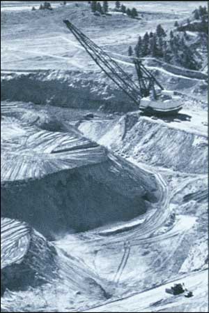
Coal Mining in Colstrip, Montana
|
The Air Force was immediately contacted. They were
mailed copies of the BLM planning documents and the tract profile
reports. Very shortly thereafter, the Air Force told us that two
underground missile silos and several miles of underground communication
cables were within the boundaries of the two tracts. Needless to say,
the Air Force was concerned about the possibility of large scale surface
mining in or near the missile sites. After a number of meetings between
BLM, the Air Force, and the company interested in leasing federal coal
in the Garrison tract, it was decided to delete the two tracts from the
September 1983 federal coal lease sale. During the next year, the Air
Force completed studies that identified buffer zones needed to protect
missile sites and the underground cables during surface mining.
It had not occurred to anyone that there could be
problems in leasing federal coal in the vicinity of underground missile
sites. There was no mention of missile sites in the BLM planning
documents, the Sakakawea and the Garrison Tract Profile Reports, and the
draft Fort Union EIS. A momentous effort had been made to keep the
public, local, state, and federal agencies involved and informed while
preparing for the coal lease sale. Yet something significant almost
slipped by. Some of the staff lost a little of their confidence that all
the bases had been covered. From that time on, the Air Force and BLM had
paid better attention to each other's activities. Even today, when I
hear of a proposed BLM surface disturbance project in Montana or North
Dakota, I ask if there are any Coal missile sites in the
area.
|
|
|
Investigations by the Department's Office of the
Inspector General and Congress' Office of Technology Assessment (OTA)
could not substantiate the charges brought by environmental groups, but
prompted two further studies of coal. The Linowes Report, Fair Market
Value Policy for Coal Leasing, issued in February 1984, reported
that the United States received fair market value in its coal lease
sales but recommended minor changes in the program. An OTA report,
Environmental Protection and the Federal Coal Leasing Program,
recommended that BLM better document the environmental impacts of coal
development and strengthen public and state participation in the leasing
process.
|
|
Coal Studies |
|
In the fall of 1987, the U.S. District Court in
Montana ruled that the Powder River coal lease sale was conducted in
accordance with the law and that fair market value was attained.
However, in the suit brought by the Cheyennes, the court directed BLM to
prepare a supplemental EIS on impacts to tribal lands.
After the OTA report was issued, Secretary William
Clark instituted a moratorium on BLM's coal leasing activities to
reevaluate the program. BLM completed a final EIS in late 1985,
strengthening its documentation requirements. Another policy change was
a return to leasing coal on an application basis—the pre-Morton
policy. Consequently, by 1988, all coal regions (except Powder River)
were "decertified," meaning BLM no longer determined where leasing would
occur.
|
|
|
The Energy Security Act of 1980 renewed national
interest in oil shale by creating an independent, government-sponsored
Synthetic Fuels Corporation. Its mission was to stimulate production of
2 million barrels of oil a day by 1992 through the retorting of shale
oil and liquification of coal. The sharp drop in oil prices during the
1980s, however, made oil shale an unattractive investment. Exxon pulled
out of its Colorado operation in 1982, while other companies also quit
or cut back their work, producing an economic bust for Colorado's
Western Slope.
|
|
Oil Shale |
|
A major issue in the 1980s concerned the validity of
oil shale claims made on 82,000 acres in Colorado prior to 1920 (oil
shale was a locatable mineral until passage of the Mineral Leasing Act
of 1920). In administrative proceedings in the late 1970s and early
1980s, the Interior Department ruled that almost all the claims were
invalid, but these findings were overturned in federal district court in
Tosco vs. Hodel. BLM was directed to transfer all title to the
claimants, including the entire subsurface mineral estate. Existing
uses, including grazing and hunting, could have been eliminated. The
Interior Department appealed the case but also followed the court's
recommendation to "explore settlement without further appeal in this
litigation."
In 1986, Secretary Donald Hodel approved a settlement
with the claimants whereby the federal government retained rights to all
oil, gas, and coal deposits on the lands and preserved Colorado's 50
percent share of mineral leasing royalties. Existing rights-of-way were
also retained, along with grazing and recreational uses of the land.
Nevertheless, environmentalists and others criticized this action as a
giveaway. The State of Colorado and ranchers whose grazing leases were
affected also protested, prompting Congress to begin a study of possible
actions with regard to the remaining unpatented claims.
|
|
|
The Federal Oil and Gas Royalty Management Act of
1982 (FOGRMA) strengthened BLM's inspection and
enforcement programs for onshore oil and gas
production. Lease operators were required to document production from wells and comply with site
security measures established by the Secretary. Penalties were set for
operators who failed to protect against theft or tampering with meters
recording production. BLM completed all inspections required on
high-production leases and launched a comprehensive training program on
inspection, drainage analysis, and unit agreements.
|
|
Oil and Gas |
|
Procedures for determining known geologic structures
(KGSs) on federal lands erupted into a major national controversy in the
1980s. How BLM classified and leased federal minerals could mean
millions of dollars in revenue gained or lost by state governments. Oil
and gas companies disagreed among themselves about the way lands should
be leased, with larger companies generally favoring competitive leasing.
Because competitive leasing included bonus bids (50 percent of which
were shared by the states), most states also favored the process.
|
|
|
ON BEING A NAVAJO COORDINATOR
by Danny S. Charlie
Navajo Coordinator, Farmington Resource Area
I have been the Navajo Affairs Coordinator for the
Bureau's Farmington Resource Area for the past 14 years. I am also a
proud member of the Navajo Tribe, the largest Indian Tribe in the United
States. I began my career with the Bureau because I saw an opportunity
to help my people and work with natural resources. As Navajo Coordinator
I help BLM make sure that the concerns of Navajos are taken into account
before any resource decisions are made. I assist in land pattern
adjustments, helping both the Tribe and the Bureau manage their lands
better. I also serve as the Navajo interpreter. (The Navajo language is
perhaps the most complicated language in the world. A code in the Navajo
language was used during World War II to convey secret information to
the Allied Forces. I understand the code was never broken!)
There are several thousand Navajos living off the
reservation in northwestern New Mexico, in a region known as the
"Checkerboard Area." The land pattern was created by a railroad land
grant but further complicated by lands taken up by Anglo and Hispanic
homesteaders, individual Navajos, and the Navajo Tribe.
Perhaps my single most important contribution has
been my work with the Bureau of Indian Affairs on the Navajo Tribe-BLM
Land Exchange. The exchange sought to secure the homes of Navajos who
had settled on the public lands but had not filed entries. It has taken
12 years so far and many public meetings and conferences with BIA and
the Navajo Tribe to work out solutions. I am still working on Navajo
occupancy problems. Two are of particular interest to me now.
One involves an 80-year old Navajo named George
Simpson. His home is on public land just inside a wilderness area. Mr.
Simpson has always lived on this spot and wanted to fix his corral and
add electricity. Since improvements of any type are not allowed in a
wilderness area, BLM is working with him and the Navajo Tribe for a
solution to the problem. The Tribe supports the idea of having the
wilderness area's boundary changed (which would require congressional
action), or resetting him to a nearby area they hope to purchase.
Mrs. Bessie Woody is an elderly sheepherder who
speaks only Navajo. She has lived on the same mesa all her life. Some
time ago she had a new home built a little west of her old location. It
was a logical choice since the new site gave her a beautiful view of Ojo
Alamo Spring, one of the (now) De Na Zin Wilderness Area's more scenic
sites. Her home unfortunately, was not on her allotment as she had
thought, but on public land. Because she believes the mistake is hers,
she is willing to move back onto her allotment but needs assistance.
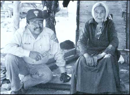
Danny Charlie and Bessie Woody (Alan Hoffmeister)
Another problem in the Checker board Area is coal.
Many Navajos are living over federal coal, in areas set aside for
preference right leasing or open to competitive coal leasing. Most
Navajos oppose coal development because they feel their traditional
homes and grazing areas will be destroyed, along with many important
religious sites. They want to retain their way of life and their bond
with the land.
BLM has tried to deal with these
concerns, yet respond to the demands of coal developers. The San Juan
River Regional Coal Environmental Impact Statement (late 1970s-early
1980s) was one such effort. BLM held several public meetings and
hearings in adjacent communities and local Navajo chapter houses. At
some of these meetings, the Navajos asked me for my personal opinions on
coal development and whether I had taken the side of non-Indians. My
answer was simple, "While it's true I work for BLM, I'm here to give you
the information in your own language so you will understand it. We need
your input." Judging from the questions I receive daily, I'm sure I have
their trust and I'm hopeful that I have done much to dispel the "Bad
Guy" image some have attributed to the government. Certainly, my work
with the Navajo people and public is challenging and rewarding—the
highlight of my career.
|
|
|
In the late 1970s noncompetitive oil and gas leases issued by BLM in
Fort Chaffee, Arkansas, through the simultaneous oil and gas leasing
program (the "SIMO" lottery) were challenged in federal court by the
State of Arkansas and supported by Senator Dale Bumpers, Chairman of the
Senate's Energy and Natural Resources Committee. The court reversed this
action and the tracts were eventually awarded through competitive
bidding.
In 1982, BLM issued noncompetitive oil and gas leases on certain
tracts in Amos Draw, Wyoming; one tract promptly sold on the secondary
market for over 1 million dollars. Widespread coverage in
the national news media stirred up additional congressional concern
about BLM's KGS procedures.
|
|
|
LIFE AS A P.E.T.
by Paul Parthun
Inspection & Enforcement Coordinator, Roswell District, New
Mexico
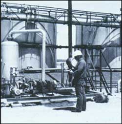
(Terry Keim)
|
"Sheesh! Another 3 a.m. cementing operation. Guess I'd better try
for some earlier sleep tonight." I gather my gear and put it into my
4-wheel-drive pickup so I won't be delayed any longer than necessary
when I get to the office at 1:30. My eyes don't want to stay open as I
drive to the office, but the cold morning air helps a little. Once in
the pickup I turn up the radio—loud—and check the drilling
location. It's fully 40 miles into the boonies. Later, even though I see
the bright lights of the drilling rig in the distance, I take a wrong
turn and the road ends at a ranch cattle watering station.
All Petroleum Engineering Technicians (PETs) empathize with such
schedules. Well drilling is a 24-hour-a-day job and PETs must be on
call to witness certain operations that are critical in protecting
the subsurface such as fresh water or potash zones. And it's curious
that most such witnessing occurs in the wee hours. PETs shrug it off
saying, "Everybody knows cement doesn't set up in daylight hours."
After the well is drilled in concordance with BLM approvals, industry
operators must continue to comply with Federal laws, regulations, and
policies as they begin to produce the formation or abandon the well.
This is the job of PETs—to ensure that oil and gas operations on
federal and tribal lands are in compliance. They are inspectors who
enforce these requirements as necessary.
Congress and the BLM have provided the PET with broad responsibilities
and authority relating to oil and gas operations as they deal with
safety, protection of the environment, proper disposition of production,
accurate reporting of production, and adequate lease site security. PETs
must exercise critical judgements in levying assessments for
noncompliance, or under certain circumstances, even shutting down an
operation.
PETs are certified by BLM only after undergoing a comprehensive training
program that includes classroom (160 hours) and on-the-job activities.
They are tested throughout this time, usually for about a year. If they
perform satisfactorily, they are recommended by their
supervisor for certification. Industry background, skills in mathematics and
knowledge of geology, together with a thorough knowledge of Federal
laws, regulations, and policies are essential for a PET to do a good job.
Then add an ability to analyze computer and records data, filing correct
reports and keeping abreast of the latest operational information, and
you have an idea of what it takes to be a PET at 3 a.m. or any other
time.
It's a good job. PETs spend much of their time
outdoors. Oil and gas activities are generally in the most beautiful and
remote areas of the western United States. PETs work alone most of the
time, making independent judgments. No place here for indecisive,
super-gregarious types.
I arrive at the rig a half-hour late but I see that
the crew isn't on hand yet to do the cementing operation. I zip up my
jacket and walk to the company trailer to introduce myself, then climb
the steel-grated stairs to the floor of the rig and into the "doghouse."
I meet the driller and his crew, thank them for the hot coffee, then
look at the driller's log to review the operation so far. I make sure
the APD is posted and the operation is laid out as approved. The well ID
is O.K. too—good operator. Out of the small window, I can see the
yellow lights of six equipment trucks about a mile off, raising a cloud
of dust visible even from here. Looks like a humongous caterpillar. On
the ground again, I walk around the rig, making sure that everything is
as it should be.
The crew arrives, hooks up, and begins forcing cement
into the hole under high pressure, surrounding the steel well casing
with an impervious layer of cement, assuring that nowhere along its
800-ft. length will drilling fluids or production be allowed to leak
into the subsurface.
The job comes off without a problem—pretty rare.
It's 9 a.m. now and I sit in the truck writing out my report. By 9:45 I'm
on the way back to the office and I radio my supervisor that I'll be in by
11.
Once there I look in the mirror and I'm glad I don't
have to be anywhere today where my appearance makes a difference. I look
like hell and I don't feel much better. But, hot water, soap, comb and
towel makes me feel like I can handle the rest of the day.
In our office PETs rotate by the job, so I know I
won't be called out again tonight. Ahh, sleep. When I arrive home my wife greets me with a little
reserve, then confides, "I've invited the Hortons over this evening. O.K.?" The Hortons?
Sheesh! I'd rather have another 3 a.m. cementing job.
|
|
|
After Amos Draw Director Burford imposed a moratorium
on oil and gas leasing to study KGS issues. BLM contracted with the
National Academy of Sciences (NAS) and the Keplinger Technology
Consultants, Inc., an independent consulting firm, to evaluate its oil
and gas leasing program, particularly its KGS determinations. The NAS
recommended that BLM broaden its criteria for determining KGSs, while
the Keplinger Technology Consultants recommended ways of improving
BLM's program, focusing on standardization and documentation. In the
meantime, Burford directed BLM to reinstate a long-standing Departmental
policy requiring thorough geologic evaluations of lands before making
KGS determinations.
BLM's intensified geologic evaluations resulted in
larger KGS areas being designated on federal lands—causing a
controversy with smaller oil companies who favored smaller KGS areas and
increased noncompetitive leasing. At the same time, however, Senator
Bumpers and others in Congress introduced bills to make all federal oil
and gas leasing competitive. Congress eventually passed a compromise
measure, the Federal Onshore Oil and Gas Leasing Reform Act of 1987,
which eliminated the government's KGS program. The act specified that
all federal oil and gas leases must be offered competitively at oral
auction; tracts not receiving bids would then be available for
noncompetitive leasing for up to 2 years.
|
|
|
RENEWABLE RESOURCES
|
|
|
The 1980s ushered in a fundamental change in the
federal government's role in natural resource management. Funding for
BLM renewable resource programs was trimmed to accommodate declining
federal budgets and Reagan administration goals to simplify federal
regulations. The Bureau focused its efforts on consolidating field
activities, cutting down on duplication in renewable resource programs.
Director Burford called for greater agency cooperation with BLM's
publics and solicited more active participation from local land users,
conservation groups, and other government agencies. Cooperative
Management Agreements, used by BLM's wildlife program with state
agencies since the 1960s, were expanded to include recreation and other
user groups.
To more fully integrate renewable resource programs
and make field operations more efficient, BLM began to collect and share
data among its programs. The ecological site inventory (ESI) was
developed to measure vegetation on the public lands. This and other
joint ventures reduced the need for programs to conduct overlapping
resource inventories. Data on vegetation came to be used as a measure of
soil erosion, deer browse, livestock forage, watershed condition, or
even dune stability in off-road vehicle areas. ESI data was used to
develop land use plans, with more specific data then being collected by
individual programs.
|
|
|
Another initiative crossing program lines during the
1980s was the Bureau's development of a policy for managing
riparian areas. BLM had managed riparian areas since the
1960s, but with most of its emphasis related to the wildlife program. During
meetings sponsored by the Congressional Research Service in 1984,
riparian management surfaced as a significant issue in BLM's range
program and was prominent during consideration of the Omnibus Range Bill
by Congress. In May 1985, BLM's National Public Lands Advisory Council
recommended that the Bureau develop a comprehensive riparian area
management program.
|
|
Riparian
Areas |
|
In a policy statement signed by Director Robert F.
Burford on January 22, 1987, riparian areas were recognized as "unique
and among the most productive and important ecosystems" on the public
lands. Riparian areas, which comprise about 1 percent of BLM lands, were
defined as "directly influenced by permanent water, with visible
vegetation or physical characteristics." BLM policy was established to
"maintain, restore, or improve riparian values to achieve a healthy and
productive ecological condition for maximum long-term benefits." To do
this, BLM would recognize riparian values in newly developed resource
management plans and activity plans and would achieve its goals through
management of existing land uses.
BLM range conservationists worked with livestock
operators to design grazing systems that would improve riparian
vegetation and streambank stability. Bureau employees in the Rock
Springs District (Wyoming) transplanted beavers to rehabilitate eroding
streams. Willow and aspen logs were delivered to streams, where beavers
built dams—which, in turn, built up streambanks, water tables, and
streamside vegetation. In Oregon, BLM biologists enhanced spawning
habitats of salmon and steelhead trout by enlisting volunteers (local
sportsmen's clubs and Boy Scout troops) to construct gabion check dams,
which created pools within streams.
|
|
|
RANGE
|
|
|
In 1978, BLM successfully negotiated with the Natural
Resources Defense Council (NRDC) to reduce the numbers of grazing
environmental impact statements (EISs) it would prepare in the field
from 212 to 158. BLM wanted to consolidate smaller planning areas and
combine its grazing EISs with Resource Management Plans that were to be
prepared for BLM Resource Areas. No grazing lands were omitted from the
EIS requirement; NRDC and the Courts agreed with the change. With
further consolidations agreed to by NRDC, BLM scheduled the last of 142
grazing statements for completion in 1989.
In 1980, BLM continued to rely on forage inventory
data to prepare EISs and set stocking rates. Many permittees—and
range scientists—took issue with this method of deciding grazing
issues because BLM was using data collected in only one season of a
given year. Livestock organizations and academia challenged the value of
data, much of which had been collected during a drought year and did not
reflect normal or long-range forage growth.
The Society for Range Management, the National
Academy of Sciences, and other groups examined this question and
recommended that BLM implement long-term studies to better reflect range
forage production, condition, and trend. Under Director Burford, BLM
moved away from relying solely on inventory data to monitoring range
conditions on public grazing lands. BLM's monitoring activities
examined
— Actual Use (number of livestock on allotment)
— Utilization (amount and type of forage used)
— Climate (monthly precipitation, temperatures, etc.)
— Trend (improving, declining, or static)
|
|
|
THE TRIALS AND TRIBULATIONS
OF BEING A RESOURCE AREA MANAGER
by Phyllis Roseberry
Grass Creek Resource Area, Wyoming
In October 1984, I became Area Manager for the Grass
Creek Resource Area. My assignment followed the completion of the Area's
Management Framework Plan and Grazing Environmental Impact Statement.
Thus, I was in an enviable position to implement a plan and actually be
a party to the changes. This aspect appeals to me because I can
experience direct feedback.
But feedback is definitely a mixed bag. Significant
improvements have been made in the rangeland, watershed and wildlife
resources but significant controversy has also been generated. This job
is challenging to say the least.
People often ask me if I think being a woman has
affected the public's or Bureau employees' reaction to me. I think there
was considerable apprehension both from the staff and from the users prior
to my arrival. Any change from the usual is always difficult to accept.
I believe focusing on the joint public land use problems before us rather
than on our individual physical differences helped develop a good relationship
and mutual appreciation. Within a relatively short time, any misapprehension
or distrust was alleviated.
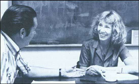
Area Manager Phyllis Roseberry with Wayne Erickson,
Wyoming State Office recreation program leader. (Dave Stout)
As for the public land users, if anything, they have
been extra polite to me. I remember being yelled at once by a permittee
who had been trespassed. In the middle of a sentence he stopped and apologized
profusely. I think he suddenly realized yelling at a woman was not proper gentlemanly
practice." I told him the yelling didn't bother me because it showed he considered me an equal
to any man who would have trespassed him. Again, finding solutions to
the problems far outweighs any differences.
I believe the team effort of a relatively small group
of diverse specialists in a resource area setting is a most exciting
situation. It offers abundant opportunities to learn more about human
nature as well as resource problems. We are all different in many ways,
but the important thing is that all of us do our jobs because we are
basically dedicated to good public land management.
|
|
|
BLM also collected data on major events such as
wildfires, insect infestation, or drought. According to Billy Templeton,
Chief, Branch of Range Management, BLM's move to monitoring was of
major benefit to the Bureau's range program: "It institutionalized range
studies over time, instead of having the BLM rely on data collected for
just one year."
BLM's range program also began to focus on allotments
where management would bring the best results. Grazing
allotments were placed in one of three categories:
"M" (Maintain) — Resource has high to moderate
production potential; producing at or near potential; present management
satisfactory.
"I" (Improve) — Resource has high to moderate
production potential; producing at low to moderate level; resource will
respond to improved management.
"C" (Custodial) — Resource has low production
potential; producing at or near potential; opportunities for improvement do
not exist.
BLM developed a more effective cost/benefit analysis
for range improvements and began to target them on "I" allotments where
they would do the most good. Working closely with allottees and other
land users during the process paid significant dividends to the Bureau:
many ranchers and conservation groups came to support the effort.
BLM Grazing Fees
1981-1987 |
| Years | Animal Unit Month Fee |
| 1981 | 2.31 |
| 1982 | 1.86 |
| 1983 | 1.40 |
| 1984 | 1.37 |
| 1985-1987 | 1.35 |
|
|
|
The grazing fee formula set by the Public Rangelands
Improvement Act (PRIA) remained in effect on BLM and Forest Service
lands until 1985. Congress then asked the agencies to study and report
on the fee structure for 1986 and subsequent years, which was
accomplished in their 1985 annual reports to Congress. The House and
Senate, however, ran out of time to consider the study and did not enact
any new legislation on grazing fees.
|
|
Grazing
Fees |
|
In the absence of Congressional action, Secretary
William Clark was instrumental in convincing President Reagan to issue
an Executive Order reestablishing the PRIA formula, but with a minimum
fee of $1.35 per animal unit month. NRDC challenged the legality of
this order, but the courts decided in favor of the government. As of
September 1988, Congress continued to study legislative proposals
setting new fee formulas.
|
|
|
|
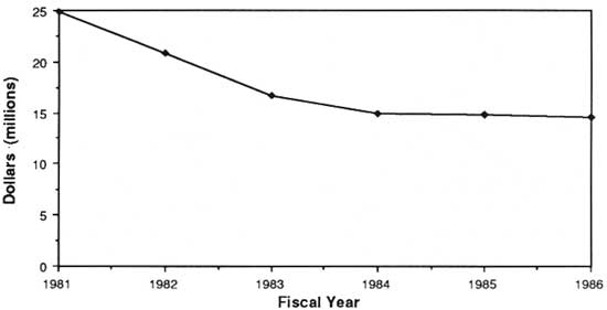
Grazing Revenues 1981-1986
|
|
|
After passage of the Public Rangelands Improvement
Act in 1978, BLM developed an experimental stewardship program to test
new approaches to improving rangeland conditions, as directed by the
act. BLM set up 16 experimental stewardship projects in eight states
with land users and other agencies (for example, the Forest Service and
state wildlife agencies) to cooperatively develop new and innovative
ways to manage public rangelands.
|
|
Cooperative
Management
Agreements |
|
Cooperative Management Agreements (CMAs) and
coordinated resource management plans grew out of this work. Director
Burford introduced CMAs to BLM's range program in 1982 to recognize
outstanding livestock operators on the public lands and assure them of
continued long-term tenure on their allotments. Operators with CMAs were
free to adjust livestock numbers, seasons of use, and kinds of livestock
grazed on their allotments within predetermined limits agreed upon and
included in the terms of the CMA. CMAs were issued for 10 years with
resource evaluations scheduled at 5-year intervals. If multiple use
objectives were met, BLM could renew the agreements—and grazing
permits—for another 10 years.
The program was never fully implemented, however. BLM
was sued by NRDC in 1984, asserting that the Bureau was allowing a
specific group of land users to exert undue influence in managing
grazing on public lands—without involving other interests in the
process. After losing the case in 1985, BLM declined an opportunity to
appeal the case and dropped CMAs from its range program.
|
|
|
In the meantime, the Nevada State Office took the
lead in developing Coordinated Resource Management and Planning (CRMP).
This process involved everyone concerned with resource management in a
given area—landowners, BLM and other agencies, resource users, and the
interested public—to address resource conflicts at the local level.
According to State Director Edward F. Spang, CRMP plans were developed
within the framework of laws, regulations, and applicable land use plans.
"Major areas of conflict were subjected to the CRMP process, including
livestock grazing, watershed problems, off-road vehicle designations,
and wilderness suitability recommendations."
|
|
Coordinated
Resource
Management
and Planning |
|
BUREAU AIR RESOURCE MANAGEMENT
by Al Riebau
Wyoming State Office
There is one resource that the Bureau has a
responsibility to manage that exists in every state, district, and
resource area. It's so universally pervasive that no other resource or
Bureau resource program could exist without it. It is also quite
probably the resource that we know the least about managing collectively
as an agency and the one to which the BLM has assigned the smallest
staff. That resource is, of course, the air around us.
Air doesn't mean just air quality to the Bureau's air
specialists. Air to us means Air Resource Management (ARM). ARM is a new
atmospheric science approach perhaps unique to land managers. It covers
abroad range of activities including climate, weather, smoke management,
pollution impact modeling, monitoring for such things as acid
rain and visibility, and regulation development coordination.
BLM originally hired air specialists to perform air
quality analyses to support EIS preparation. This was indeed a
one-dimensional activity, involving only air quality work. Most of it
centered around projecting the potential for air pollution against
various state and federal air standards. It was, of course, a
bread-and-butter activity and Bureau specialists enjoyed a well-defined
if hectic role. At one time the Bureau had a staff of 12
specialists busy with these kinds of activities. Some of these early
specialists worked on upwards of seven EIS teams at a time and
administered analysis contracts to support the documents.
As minerals markets softened, EIS work dwindled. ARM
personnel have gone the way of the EIS frenzy and we are now down to
four full-time positions within the agency. At this writing, three State
Office ARM specialists fill both state and agencywide functions. The
Utah State Office specialist, Dr. William Wagner (hired in 1975, the
first ARM specialist employed by any federal land management agency), is
the Bureau's lead technical expert for air impacts from hazardous
wastes. The Colorado State Office specialist, Scott Archer, is the lead
for visibility (atmospheric clarity as it relates to air pollution)
issues. I serve as a technical lead for acid rain issues, wilderness air
quality and monitoring issues, plus some aspects of air quality and
smoke management, and air pollutant modeling. The Washington Office
program manager, Stan Coloff, provides overall program guidance and
policy development besides coordination of training and interagency
relations. Carrying out these Bureauwide duties at State Offices doesn't
fit into the normal scheme of the Bureau's organizational structure. In
truth, the factor that has allowed the program to function has been the
support of managers who make allowances for the unorthodox (and
recognize that these specialties at times must be shared) for the good
of the Bureau as a whole.
The development of ARM in the Bureau is far from
over. Applying climate information, especially if global climates shift
as some predict, will require specialists with knowledge of
Bioclimatology. As new particulate and visibility regulations are
applied, ARM specialists in smoke dispersion prediction and dispersion
meteorology will become more necessary. The challenge for the Bureau's
ARM specialists will be to provide the support that these issues will
demand. This means learning to manage the atmosphere as a resource that
can be renewed and enhanced, with the Bureau taking an active role.
Nothing as pervasive as the Earth's atmosphere can remain unnoticed for
very long.
|
|
BLM's HAZARDOUS MATERIALS PROGRAM
by Myra Musialkiewicz and Michael Giblin
Hazardous Materials Staff
In April 1985, hydrogen sulfide gas was released from
a liquid waste lagoon at the Lee Acres Landfill near Farmington, New
Mexico. The gas caused temporary illness and discomfort to landfill
users and emergency response personnel. At the same time, there was a
release of surface water from one lagoon that ran into the adjacent
arroyo.
Under the Recreation and Public Purposes Act, BLM is
authorized to lease its lands to municipalities for varied public
purposes. San Juan County in New Mexico holds such a lease to operate
the Lee Acres Landfill, one of 336 operating landfills authorized under
the Act. The lease allowed the County to provide essential sanitation
services at a very low cost.
The Bureau, as landowner, is one of the parties that
is responsible for protecting public health and safety. This
responsibility derives from federal laws, specifically the Comprehensive
Environmental Response, Compensation, and Liability Act, as amended
(CERCLA, the "Superfund Act"). Private parties, local governments (like
San Juan County) and states also have responsibilities under this
statute as well as related federal and state laws.
BLM studied the site and identified potential risk,
from several possible sources, to local well users. Once identified, the
Bureau quickly took action to deal with the potential threat to the
public health of landfill users and subdivision residents without regard
to who was actually responsible for the threat. Once the imminent threat
was handled, BLM began working on long-term assessment and control of
risk in the area. Because of the other possible sources of
contamination, the Bureau expanded the area of study to include not only
the landfill but the surrounding industrial area that contains a
refinery and numerous oil and gas wells. The study area as now defined
contains 2,100 acres of federal, state, and private lands.
Since the site investigation, BLM has conducted
soil-gas contaminant analyses and extensive hydrogeologic and water
quality studies throughout the area, including the San Juan River. BLM
is continuing to monitor groundwater levels and quality through 19
detection wells that were installed in the larger site area. In
addition, the Bureau is in the process of awarding a contract to conduct
a remedial investigation/feasibility study/EIS for the entire site. The
contractor will determine the nature, quantity, and source(s) of
pollutants and contaminants at the site and will include a search for
potentially responsible parties who may share the costs of any necessary
site cleanup. It will also examine alternative means for site cleanup
and make recommendations for consideration by the Secretary as part of
the decision process.
By 1988, BLM spent in excess of $1.3 million dealing
with this contamination problem, with another $3 million anticipated for
the additional studies. Based on EPA estimates, a site of this size
could cost as much as $25 million to clean up. The cleanup is scheduled
to begin in mid-1992, with monitoring continuing a minimum of 20
years.
In the meantime, BLM is not issuing any more R&PP
leases for landfills; rather, it will transfer lands needed for
municipal landfills and other waste disposal facilities out of federal
ownership. In 1989, the Bureau will begin audits of other landfills on
the public lands for compliance with EPA regulations and BLM
environmental stipulations.
|
|
|
Soil, water, and air activities were placed in BLM's
range program in 1982. Since then the branch has conducted soil surveys
on the public lands at a rate of 4 million acres per year. Of 157
million acres targeted for such surveys, 129 million have been
completed. The branch also developed an automated soil information
system to integrate existing soils data with other resource
information.
|
|
Soil, Water,
and Air
Activities |
|
Watershed projects in the 1980s included nine
hydrologic modeling programs focusing on water quality, erosion, and
precipitation. Eight watershed activity plans were implemented in
support of the Colorado River salinity program and four in support of
flood and sedimentation mitigation. Instream flow assessments were
completed for the Beaver Creek National Wilderness River in Alaska and
the San Pedro River management area in Arizona to identify resources in
these areas and the amounts of water required to sustain them.
|
|
|
BLM has supported more than 20 years of research by
the Agricultural Research Service (ARS) at the Reynolds Creek
Experimental Watershed in southwest Idaho. Congress established the
facility in the early '60s, to collect data on runoff and water yields
from plateau and foothill grazing areas. The project was undertaken to
facilitate the long-term improvement of grazing and rangeland
management, and has been the largest and lengthiest watershed research
project BLM ever participated in.
|
|
Reynolds
Creek
Experimental
Watershed |
|
The Reynolds Creek watershed contains a wide range of
environmental conditions found in a variety of western rangelands.
BLM/ARS research yielded important data on resource monitoring and
modeling, precipitation and climate, streamflow and runoff, erosion and
sediment, water quality, vegetation, and soils.
During the 1980s, the extensive data base on
rangeland activities was used to create simulations that estimate
impacts and magnitudes of land practices in land use plans. A 1984
conference of federal and state land management agencies began an era of
transferring Reynolds Creek data and analysis techniques into management
practice.
Starting in 1981, BLM's air resources program
participated in the National Atmospheric Deposition Program to help
quantify water chemistry (including acid rain) on the public lands. BLM
also developed smoke and pollution estimation models which quantify
atmospheric changes and dispersion potentials.
|
|
|
WILDLIFE
|
|
|
BLM's role in managing fish and wildlife resources on the public lands
became more widely recognized in the 1980s. Fish and Wildlife
2000, a strategic plan for the program, was signed by
Director Robert Burford on May 21, 1987. It is the first long-range plan
developed for the wildlife program, calling on BLM to manage "with
emphasis on ecosystems to ensure viable populations and a natural
abundance and diversity of wildlife, fisheries, and plant resources on
the public lands."
BLM's wildlife program features three components:
wildlife habitat management, fisheries habitat management, and
threatened/endangered species management. The Bureau accomplishes its
goals by implementing habitat management plans (HMPs); it also specifies
fish and wildlife objectives in other activity plans and implements
recovery plans for threatened and endangered species. In addition, BLM
biologists place stipulations in leases, licenses, and permits to
mitigate adverse impacts to fish and wildlife habitats and implement
on-the-ground improvement projects.
|
|
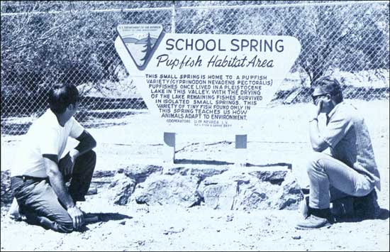
|
|
BLM has worked on cooperative fishery projects since the
early 1960s including the Las Vegas District's School Springs project to
restore and maintain habitats for the endangered Warm Springs pupfish.
Jim Deacon (left), University of Nevada, Las Vegas and Lew Myers, BLM.
(Jim Yoakum) |
|
|
Since 1980, 160 HMPs were prepared in BLM, bringing
the total developed to 399. More than 100 have been fully implemented,
with 212 more in the process of being implemented. Fish are priority
species in 106 aquatic HMPs prepared to improve habitat on 3,100 miles
of streams crossing public lands, according to Art Oakley, fishery
biologist in the Oregon State Office. The major species for 50 of these
plans are either endangered or threatened, or candidates for listing. In
addition, Bureau biologists contribute to interagency recovery plans for
threatened or endangered species, including the Warm Springs
pupfish in Nevada and the humpback chub, bonytail chub, and Colorado
squawfish in the Colorado River system. A total of 73 recovery plans
have been developed, 56 of which are currently being implemented.
|
|
|
DESERT BIGHORN AND BLM
By Allen Cooperrider
BLM Service Center
Desert Bighorn sheep are the only ungulate native to
the southwestern deserts and mountains. About 80 percent of the current
desert bighorn habitat is on federal land, most of which is administered
by BLM. Although once in danger of extirpation, desert bighorns are now
well on the way to recovery. BLM's past efforts have been key to this
effort and the future of the desert bighorn depends on BLM's continuing
efforts.
Most of the native ungulates of North America, such
as elk, mule and white-tailed deer, and antelope had severely declined
by the beginning of the 20th century. Desert bighorn continued to decline
well after the other ungulates were on the road to recovery. About 1
million desert bighorn sheep were present in North America at the
beginning of the 19th century. By the mid-20th century their numbers had
declined to less than 10,000 due to overhunting, disease, competition
from livestock and burros, and human disturbances.
In 1950, BLM began efforts to protect bighorn sheep
and their habitat. These efforts were the first such efforts and the
beginning of BLM's formal wildlife program. By 1960, BLM was actively
working with biologists from state agencies to improve desert bighorn
habitat. Those practices—cooperation with state wildlife agencies,
conservative use of bighorn ranges by livestock, water development,
avoidance of shifts from cattle to domestic sheep use, and preservation
of critical areas in public ownership—have remained a cornerstone
of BLM efforts for desert bighorn. By hiring wildlife biologists and
establishing a wildlife program in the mid-1960s, BLM further enhanced
several of its recovery programs.
In 1985, Congress appropriated a Challenge Grant of
$300,000 to BLM specifically for the recovery of desert bighorn sheep.
The appropriation stipulated that the grant be matched by private
sector funding or in-kind services. With this, BLM was able to initiate
numerous projects, including water developments, inventory and monitoring,
and studies to determine causes of lamb mortality. Currently, about $1
million a year is being spent (including the Challenge Grant, matching
contributions, and base funds) to continue these efforts.
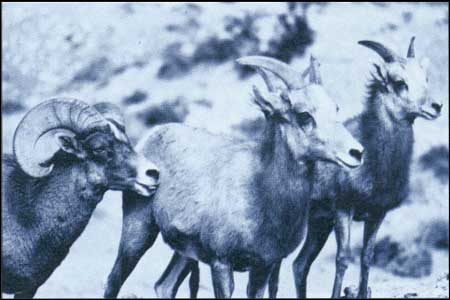
(BLM)
In January 1988, Director Burford signed a rangewide
plan for desert bighorn sheep that outlined a balanced program of
inventory, on-the-ground projects, monitoring and research for
facilitating recovery of desert bighorn in 115 habitat areas in the
Southwest. By implementing this rangewide plan, BLM should be able
to achieve a substantial recovery of sheep within the next 25 years.
|
|
A WILD HORSE ROUNDUP
by Robert E. Stewart
Nevada State Office
Management of America's wild and free roaming horses
and burros has given the BLM a unique role in maintaining a colorful
aspect of Western lore—the roundup. The modern rancher conducts few
cattle roundups because of costs. Yet the roundup remains the only
effective way to remove excess horses and burros from western
rangelands.
In some places, the animals are water-trapped. A
temporary fence is placed around a water hole, and when thirst overcomes
caution, horses enter the enclosure, only to have a gate close behind
them.
Far more common is the contract helicopter gather.
This effort requires the Bureau wild horse specialist to thoroughly know
the herd and the herd-use area. Before a contract is let, the
specialist, through reconnaissance flights, locates the horses and
identifies those to be removed.
Then trap sites are selected. These must be near a
road, because the horses will be trucked to a center for freeze
branding, vaccinations, and eventual adoption. More than a hundred metal
fencing panels arrive—enough for a main trap pen, including
sorting pens to separate mares, wet mares and foals, and stallions. Long
wings of panels, a quarter mile or more, reach out from the trap
entrance, creating a funnel effect. Experienced contractors can erect
these in one day, two at the most.
Often, camouflage is used. Brush may be cut and woven
into the panels. Canvas may be used to break the straight lines so the trap is less
obvious to the spooky horses.
As the trap nears completion, the Bureau specialist
and capture pilot reconnoiter the area by helicopter, being careful not
to disturb the bands of horses. Now the colorful part begins. Still
camera and motion picture photographers start gathering to capture some
of the spirit and color of this bit of the Old West.
The helicopter, at low altitude, circles out to haze
the horses toward the mouth of the trap. Drawing on experience, the
pilot moves the horses at a pace which tires, but does not exhaust,
them. One band may be "parked" while the pilot circles back to draw in
more, grouping 35 to 75 horses some distance from the trap.
Now the pilot swings back and forth in the sky like a
talented, tenacious sheepdog at work, moving the whole herd. Slowly at
first, then faster, the pilot hazes the herd toward the open end of the
trap.
Meanwhile on the ground, a trained "parada" (or
"Judas") horse has been led to a point just outside the open end of the
trap wings. It is held by a worker crouched close to the ground. As the
helicopter-pushed horses draw closer, the tethered horse is released. It
runs toward the trap, followed by a thunder of dust-raising hoofs.
Timing is critical, for the worker holding the parada horse must get out
of the way, unseen, to avoid personal injury or spooking the herd.
Deep in the trap wings, another crew member
dashes out behind the horses, "closing" the trap with a canvas "gate."
Though the horses could easily tear through the cloth, few of them do,
never having seen "walls" before.
A more solid gate closes. The helicopter lands, and
the next phase begins.
The startled horses mill about the trap, often
charging around as they spot people outside. Once the horses are sorted
a period of quiet and settling down begins. A state brand inspector
often reviews the horses for signs of ownership; not only brands, but
signs of having been saddled or having worn halters will put horses
under jurisdiction of the state estray laws.
Brought into close proximity, the horses need special
care. They are susceptible to injury and sickness, especially in the
first few days. If they have been run too hard or over hard rocky
ground, leg and hoof injury may take several days to show up. But the
horses are now cared for daily by some of the best trained horse
handlers in the world, the managers and staff of BLM wild horse
facilities.
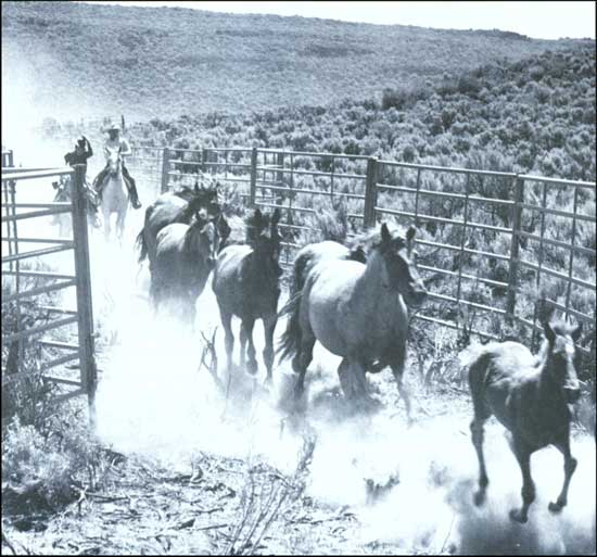
Roundup outside Susanville, California. (BLM)
|
|
|
Increased cooperation and partnerships have been
developed with conservation organizations, commodity groups, and
landowners to encourage outside participation in habitat improvement
projects. For example, national-level agreements were signed with the
Rocky Mountain Elk Foundation, Ducks Unlimited, the National Wild Turkey
Federation, and Trout Unlimited to expand cooperation and joint
activities at the field level. Congressional appropriations of challenge
cost-share matching funds (funds set aside to match donations from
private sources) made increased cooperative efforts possible. To
encourage private investments on the public lands, Fish and Wildlife
2000 also calls for development of a "gift opportunity catalog" to
promote contributions to fish and wildlife projects, including land
acquisition or access needs.
BLM placed greater emphasis on developing
interdisciplinary rangewide management plans for certain high-visibility
species, such as the desert bighorn sheep, desert tortoise, anadromous
fish, waterfowl, and raptors to provide specific strategies for key
species and ecosystems. An emerging issue for BLM is conservation of
biological diversity on the public lands. The Office of Technology
Assessment defines biological diversity as "variety and variability
among organisms and the ecological complexes in which they occur....Thus,
the term encompasses different ecosystems, species, genes, and
their relative abundance." To date, most of this concern has
concentrated on threatened and endangered species, but according to BLM
biologist Allen Cooperrider, the Bureau's role in conserving biological
diversity at the community or ecosystem level is likely to increase in
the future.
|
|
|
WILD HORSES AND BURROS
|
|
|
BLM's wild horse and burro program in the 1980s
focused on removing excess animals from the public lands to bring their
populations down to appropriate management levels, which were established
through BLM's planning process for about 95 percent of its herd
management areas. In conjunction with the National Academy of Sciences,
the Bureau also awarded contracts for research projects on fertility
control and population genetics of wild horses. Removals from 1980 to
1988 reduced horse and burro populations by about a third, but BLM did
not expect to reach its management objectives until the early 1990s.
Because controversies continued to elevate this issue to national
prominence, in 1988 Director Burford asked Congress to hold oversight
hearings to provide the Bureau with guidance on administering this
difficult program.
BLM found homes for nearly 75,000 excess wild horses
and burros through its Adopt-A-Horse program since 1980, but
many older horses proved to be unadoptable. Although the law authorizes
humane destruction of unadopted animals, the American public strongly
opposed this approach. BLM has since turned to new initiatives,
including an increase in adoption efforts in the East and the
establishment of a pilot sanctuary for unadopted wild horses on private
lands in South Dakota. BLM also sent horses to satellite (temporary)
adoption centers in areas where adoption demand existed. From 27 such
centers in 1983, the number of satellites grew to 71 in 1987. BLM also
worked with prison systems in four states (California, Colorado, New
Mexico, and Wyoming) to establish inmate wild horse training programs to
increase the adoptability of wild horses.
|
|
|
FORESTRY
|
|
|
During the inflationary years of the late 1970s and
early 1980s, a national housing boom caused a rash of speculative
bidding for timber from federal lands in Oregon and Washington. Bids
rose from around $100 per thousand board feet to $300 and $400. In 1982
the nation entered a recession. Timber prices plummeted to the
$100-per-thousand level and sometimes below. The high-bid contracts
became uneconomical; companies could not harvest without incurring
severe financial hardship. Many faced bankruptcy. In addition, it was
anticipated that massive defaults on contracts would cut even further
into the already shrinking receipts going to both the O&C Counties
and the U.S. Treasury.
BLM and the Forest Service created a program in 1982
to extend the term of the high-bid contracts. The intent was to give
contract holders more time in which to harvest the timber, hoping that
lumber prices would rise, and to blend high-bid and low-bid timber to
soften the financial impact on the contract holders. In 1984 Congress
passed the Timber Contract Payment Modification Act which allowed some
contracts to be bought out by the holders at a reduced price and the
remaining contracts to be extended through 1989.
|
|
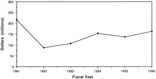
|
|
Timber revenues 1981-1986
|
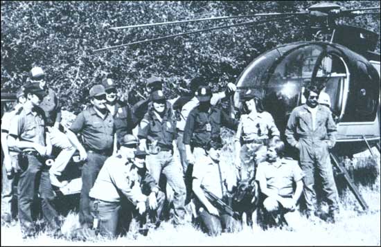
|
|
BLM law enforcement has "come of age" in the 1980s with Bureau agents
and rangers participating in cooperative efforts with other agencies,
such as this Interagency Marijuana Raid Team, consisting of BLM agents
and the Oregon State Police in the Roseburg District. (BLM)
|
|
|
During the 1980s environmental groups protested
several O&C activities. One effort involved limiting BLM's use of
herbicides on competing vegetation in young forest plantations. A 1984
legal challenge was successful; use of herbicides was stopped by court
order until BLM could analyze their use on the public lands.
Preserving old-growth forests also became an issue;
virtually all of the old-growth Douglas Fir forests remaining in the
Pacific Northwest are found on federal lands. Environmentalists argued
that management of O&C lands under the principle of sustained yield
should be revised in favor of full multiple use. The northern spotted
owl, a subspecies native to these same Douglas Fir forests, is thought
to depend heavily on old-growth and mature forests as habitat.
After 10-year plans for western Oregon forests were
completed in the early 1980s, BLM and the Oregon Department of Fish and
Wildlife agreed to protect habitat for 90 pairs of owls through 1987. In
that year the agreement was renewed through 1990 and the number of pairs
for which habitat was to be provided was increased to 110.
In 1986, BLM's analyses of the effect of timber
harvest on the owl in the early-1980s environmental impact statements
was challenged. After State Director William Luscher found the analyses
to be adequate, a court suit was begun. A district court ruling
favorable to BLM is currently under appeal.
|
|
|
In addition to its management of O&C and
commercial public domain forests, BLM started to manage woodland areas
in the 1980s. These areas include pinyon-juniper woodlands in Utah,
Nevada, New Mexico, and Arizona valuable for fuelwood (harvested by both
commercial interests and individuals), plus items such as pinyon nuts
and Christmas trees. BLM hired a forester in each district in Nevada to
manage this program.
|
|
Woodlands |
|
CULTURAL RESOURCES
|
|
|
Prior to the 1980s, the idea of managing cultural
resources in BLM was almost entirely tied to compliance with Section 106
of the National Historic Preservation Act and to assisting other BLM
programs in fulfilling their objectives. As the Bureau's compliance
proficiency grew—and as FLPMA's multiple use emphasis became more
ingrained in the Bureau—the cultural resource program was able to focus
on a more long-term, planning-based management model.
Initial program manuals adopted in 1978 were
developed with the conviction that the cultural resources program should
be like other BLM resource management programs, according to John
Douglas, current program leader in Washington. "Just as in the more
traditional BLM programs, managers should be able to come out of a
comprehensive land use planning process with cultural resource
allocations and then manage the resources according to the allocations."
A new BLM planning guidance manual in 1986 incorporating these concepts
was the Bureau's first significant step toward realizing these
ideas.
BLM's role in managing cultural resources for the
public's benefit was given new visibility when the Anasazi Heritage
Center opened in the Four Corners area of southwest Colorado in August
1988. Built as an interpretive, curatorial, and research facility, it
will house millions of artifacts and records from the Dolores Project,
one of the largest archaeological recovery projects ever undertaken. The
BLM-managed facility will serve as a regional repository for the Bureau
of Reclamation, the Forest Service, and BLM. In addition, it will
provide visitors with interpretive programs and students with education
and research opportunities.
|
|
|
RECREATION
|
|
|
Demands for recreational opportunities on BLM lands
have continued to grow—an unsurprising fact when one considers that
90 percent of Americans participate in some form of outdoor recreation.
In 1987, BLM estimated that there were 56.4 million visits to the public
lands, a three-fold increase since 1968.
Because of other national priorities, BLM was not
able to focus much attention on its recreation program through the early
and mid-1980s. During this time, however, there were significant increases
in ORV use, river running, caving, and snowmobiling on the public
lands, plus the traditional uses of hunting, fishing, and back-country
exploring.
|
|
|
CULTURAL RESOURCE MANAGEMENT IN ARIZONA
by Gary Stumpf, Archaeologist
Arizona State Office
Cultural resource management has really matured in
the past 10 years. We started out as rather native stepchildren,
asking as many questions of ourselves as the Bureau was asking of us.
The very concept of cultural resource management was new, and BLM
was one of the pioneers forging its standards, its procedures, and
even its jargon. It has been a process of learning and adjustment
for all of us. Some of that adjustment has been awkward, but has in
general been salved with a fair amount of humor. The result is that
the cultural resources program has emerged with a secure footing in
helping BLM carry out its multiple use mission.
One of our greatest challenges in cultural resource
management today is communicating our knowledge and enthusiasm about
the resources we manage to the general public who pays for the work we
do. The public has always had a legitimate stake in the way we have
managed historical and archaeological resources; after all, we wouldn't
be in the business we are in without some far-reaching legislative
expressions of public will. Few people have actually participated
in cultural resource management activities, however, and the public's
sense of ownership of, and responsibility for, those resources is not
well developed.
Archaeologist Jennifer Jack working with students. (Peggy Avey)
|
Arizona is particularly fortunate in having two
very large and active amateur archaeological societies—the
Arizona Archaeological Society and the Arizona Archaeological and
Historical Society. We also seem to have an uncommon number of
non-affiliated amateurs and others who are willing to devote their
efforts to preserving the past. In the past three years alone,
amateur archaeologists and other volunteers contributed 18,000 hours
of their time to assist Arizona BLM in cultural resource management
work. That's a remarkable demonstration of public support, reflecting
a spirit of interest and cooperation that I hope we never take for
granted.
Our volunteers come from all over the United States;
one of them last year even came from England. Some of them belong to
organizations we don't usually associate with cultural resource
preservation. For example, members of the Arizona Desert Racing
Association recently volunteered to help us construct a fence around
an archaeological site to protect it from off-road vehicle damage.
Every once in a while things like that happen to remind us that
stereotypes are not valid.
Arizona is also fortunate in having the most comprehensive
cultural resource public awareness program in the nation, spearheaded by the
State Historic Preservation Office. The program centers around Arizona
Archaeology Week, an annual event which includes exhibits at the state
capitol and local communities, tours of archaeological and historic sites,
presentations to schools and community groups, poster contests, newspaper
and television coverage, participation on radio talk shows, and other
activities. BLM is a major participant in this event each year, and we
cannot help but believe that these efforts have gone a long way toward
shaping public attitudes on the need for preserving the fragile record of
our past.
|
|
|
By the late 1980s, the recreation program assumed a
more dominant role in the Bureau. Several factors contributed to this
increased emphasis, not the least of which was the President's
Commission on Americans Outdoors, established by Ronald Reagan in 1986.
Public meetings and a subsequent report heightened the public's interest
in America's recreation resources, in a manner somewhat analogous to the
work done by the Outdoor Recreation Resources Review Commission in the
late 1950s and early 1960s.
|
|
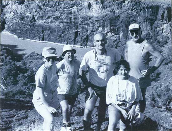
|
|
A very special group of people (from left to right, Barbara Hodel;
BLM Utah State Director, Roland Robison; Secretary of the Interior,
Donald Hodel; Miriam Mueller, friend of the Hodel family; and Moab
District Manager, Gene Nodine) went on a fact-finding tour in 1987 to
discuss BLM river management. They are shown at Vista Viewpoint
overlooking Westwater Canyon's gorge on the Colorado River in
Southwestern Utah. (Mary Plumb)
|
|
|
Along with this effort, BLM developed Recreation
2000, a long-term strategic plan for the management of outdoor
recreation opportunities on the public lands. The plan presents an
overview of BLM's recreation and wilderness programs and provides policy
for future efforts, including visitor information and interpretation;
resource protection and monitoring;
land ownership and access adjustments; partnerships and volunteer
programs; and facilities, permits, fees, and concessions.
|
|
|
WILDERNESS
|
|
|
Since 1981, BLM has managed 24.6 million acres of
public lands in 855 separate locations as wilderness study areas while
it prepared environmental impact statements to determine their
suitability for inclusion to the National Wilderness Preservation
System. Under FLPMA, BLM must complete its studies of these areas by
1991.
By 1988, Congress designated 25 of these areas
(totaling 450,000 acres) as wilderness, starting with Bear Trap Canyon
in the Lee Metcalf Wilderness in Montana in 1983. Aravaipa Canyon in the
Safford District and eight areas on the Arizona Strip District were
designated in the Arizona Wilderness Act of 1984. Cebolla and the West
Malpais wilderness areas were designated in the Albuquerque District
under the El Malpais National Monument and National Conservation Area
Act of December 31, 1987.
|
|
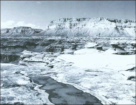
|
|
BLM Wilderness Study Area, Kanab Creek Esplanade, Hack Canyon,
Arizona. (BLM)
|
|
|
The Bureau's first wilderness management plan was
completed for Bear Trap Canyon in 1984. By 1988, 12 draft or final
plans had been completed. BLM continued to develop management
guidelines for its designated wilderness areas, including procedures
governing aircraft flights, management of fish and wildlife habitats,
and regulation of mining claims made in areas before they were
designated.
|
|
|
THE EAST MOJAVE NATIONAL SCENIC AREA
by John Bailey
Needles Resource Area
The East Mojave covers 1.5 million acres, most of it
public lands managed by BLM. All of the classic land uses are
here—grazing, mining, recreation. The classic conflicts are here
too, all within view of the 15 million residents of southern California
and Nevada.
The California Desert often brings to mind off-road
vehicles, sand dunes, and acres of creosote. The East Mojave, by
contrast, has no "open areas." It contains pinyon-juniper woodlands and
mountain peaks with white fir. While recreation in the area still
requires vehicles, the 3,000 miles of roads and trails show very little
incidence of cross-country travel. Most everyone at some point gets out
and takes a walk. Interestingly, a casual observer would be hard-pressed
to tell whether a particular group is affiliated with a
conservation/preservation group or one of the many ORV groups in the
region—they all do about the same thing when they come to the East
Mojave and, in fact, individuals often belong to both groups.
In the past, public lands singled out for special
attention were usually transferred to another agency that had the
funding or skills to manage the area. The "old" BLM was merely a
temporary caretaker. No more. FLPMA redefined BLM, allowing it to grow.
In its desire to intensively manage unique areas, the "new" BLM stood on
the cutting edge of the public debate on the proper balance between
conservation and use of federal lands. Special areas such as the East
Mojave National Scenic Area (or El Malpais), King Range and the proposed
San Pedro National Conservation Area are important not only for the
resources that led to their designation, but for their aesthetic
qualities. The "new" BLM will be challenged in achieving this delicate
balance.
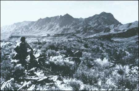
View from Wildhorse Mesa to Providence Mountain. (BLM)
How BLM develops recreational opportunities in the
East Mojave will certainly set a tone for the region and perhaps the
agency—arguments over developed campgrounds vs. primitive
backcountry camping; fear that enhancing recreation opportunities will
bring in too many visitors; controversy over whether hiking trails
should also be used by equestrians or mountain bikes (expected to become
a major activity in the not too distant future); firearm use; and the
age-old argument (for BLM. anyway) of exactly what is a "proper"
road?
How BLM handles the thorny issue of mining and
grazing in a scenic area will also set an important precedent. We
already require plans of operation for most activities, along with
performance bonds. The future will most likely bring some attempts to
define what undue and unnecessary degradation really means, and there is
the ticklish issue of miners who are more interested in mining investors
than ore. But these are not merely problems or conflicts—they are
opportunities for BLM to tell the public about multiple use, what we are
and what we do, and to redefine ourselves in the process.
|
|
WILDERNESS REVIEW PROCESS IN UTAH
by Gregory F. Thayn
Wilderness Coordinator and EIS Team Leader, Utah State Office
The BLM wilderness review in Utah began in 1978
with an inventory of the 22 million acres under BLM management.
Studies are still in progress as of 1988 and the BLM anticipates
possibly several years of interim management before Congress will
consider wilderness designation for public lands in Utah.
The review has been filled with controversy from the
outset. Many of the issues relative to the Wilderness Act that were
debated in the 1960s were never resolved and continue to complicate the
Wilderness Review. Definitions and applications for terms such as "road,"
"outstanding," and "substantially unnoticeable" are subjective and can
never be consistently understood or applied by everyone involved in the
process.
The history of the BLM's Utah wilderness review is one
of decisions by BLM and appeals by other parties. Constituencies have
organized on both the pro-wilderness and anti-wilderness sides of the
issue. The BLM has come to know the Southern Utah Wilderness Alliance, the
Utah Wilderness Coalition, and the Utah Wilderness Association on the
pro-wilderness site and the Multiple-Use Coalition, Utah State Legislature,
and association of local government and mineral development interests on
the anti-wilderness side. Misinformation abounds; facts never stand in
the way of a good solid opinion.
Contributing to the problem is the fact that Utah possesses
some outstanding areas that obviously meet the Wilderness criteria, but it also
contains an abundance of resources such as uranium, coal, and tar sand. Some of
the areas such as Sid's Mountain Wilderness Study Area, are highly regarded by
both wilderness and off-road vehicle enthusiasts and those who want a "wilderness"
where they can use their off-road vehicle. The issue is complex and "compromise"
is not part of the vocabulary for discussions between opposing factions.
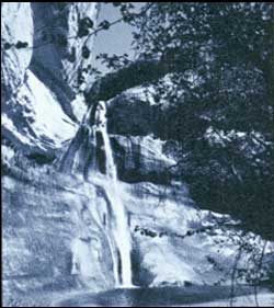
(BLM)
|
BLM's Wilderness Study Areas include approximately 3.2
million of the 22 million acres of public lands in Utah. Citizen alternatives
range from the Earth First, 16 million-acre alternative that ignores the presence
of intrusions and land ownership, to the zero-acre, NO MORE WILDERNESS, alternative
endorsed by the Utah State Legislature. More moderate alternatives of 3.8 and
5.2 million acres are proposed by the Utah Wilderness Association and the
Utah Wilderness Coalition.
The Utah BLM Statewide Wilderness Draft Environmental
Impact Statement (EIS) was published in 1986 and some 4,496 submissions
with a total of 6,213 signatures were received during the comment period.
The Final EIS will be completed in 1989 and the Secretary of the Interior
will make wilderness recommendations to the President in 1991. The real
test of the process will come in the legislative forum where Congress will
hear the opposing viewpoints and compromise will be a necessity.
|
|
|
In July 1988, the Justice Department concurred with
an opinion by Interior's Solicitor which found that Congress did not
intend to reserve federal water rights for wilderness areas when it
passed the Wilderness Act of 1964. The opinion noted that Congress could
reserve water rights for wilderness areas at any time or seek them under
state law. According to Secretary Donald Hodel, "This opinion will help
provide a sound basis for the ongoing creation of new wilderness areas
while preserving state-law water rights which, in the West, are the
lifeblood of most state economies."
|
|
|
LANDS
|
|
|
Conveyance of in-lieu land to states totalled 415,000
acres by 1988, leaving fewer than 90,000 acres of public lands for
conveyance in the lower 48 states. Land exchanges were a high priority
under Director Burford; 1.6 million acres of public lands were exchanged
under his tenure for 2.1 million acres of state and private lands to
consolidate ownership patterns and promote more efficient land
management. More than 107,000 acres of BLM lands were sold to provide
for community expansion. BLM continued to designate special management
areas on the public lands. By 1988, the Bureau managed 162 natural areas
totaling 2.4 million acres and more than 250 Areas of Critical
Environmental Concern comprising 5.1 million acres.
|
|
|
ALASKA
|
|
|
The Alaska National Interest Lands Conservation Act
of 1980 (ANILCA) decided how the state's public lands would be allocated
and managed. In addition, ANILCA modified sections of both the Statehood
Act and the Alaska Native Claims Settlement Act regarding issues such as
ownership of inland waterways, easements, Native allotments, the state
land selection period, and certain land conveyances to the state and to
Alaska Natives.
|
|
ANILCA |
|
BLM conveyed more than 34 million acres of land to
Alaska since 1980, with the state receiving title to 84 million acres
(over 80 percent of its allotment) by July 1988. In addition, more than
17.8 million acres were transferred to Alaska Native corporations. As of
July 1988, title had passed for 36 million acres, or more than 70
percent of the land granted by ANCSA.
In total, BLM Alaska has been given the job of
conveying 148 million acres of land since 1959. In the 1980s BLM adopted
a "Patent Plan Process" to streamline the required field examinations,
survey procedures, and patent preparation time. BLM plans to complete
its land transfers by the year 2008.
|
|
|
Inland waterways cover more than 10 million acres of
land in Alaska. BLM is currently determining how many of them are
navigable. Until the Bureau completes this determination, it will not know
which of these lands belong to the state under the Statehood Act. The
Submerged Land Act of 1988 ratified as a matter of federal law a 1983
Secretarial policy that applied similar standards to Alaska land
ownership as has been applied to the Lower 48. In general, the act
provides that the state and Alaska Native corporations will not be
charged for lands under lakes larger than 50 acres or rivers wider than
3 chains (198 feet).
|
|
Inland
Waterways |
|
In 1988, BLM managed 90 million acres in Alaska. When
the title transfer program is completed, BLM will manage approximately 64
million acres, while retaining some functions (such as firefighting) on
150 million acres. ANILCA greatly expanded America's national parks and
wildlife refuges; in addition, more than 70 percent of all federal lands
classified as wilderness are found in Alaska. Sixteen national wildlife
refuges cover 75 million acres, while national forests cover 23 million
acres. The National Park Service administers some 50 million acres of
parks and preserves. ANILCA also created 25 wild and scenic rivers in
Alaska and identified 12 river systems for further study.
|
|
Other Federal
Lands |
|
Under ANILCA, BLM's responsibilities for land
management picked up something without parallel in the Lower 48: a
requirement under Section 810 of the act to evaluate the effects of its
actions on traditional subsistence uses of the public lands by rural
residents—Indians, Aleuts, and Eskimos. Hunting, fishing, trapping,
and the collecting of firewood and various plant foods have always
occurred on these lands. With ANILCA's new mandate, BLM began to
analyze the effects of its actions (withdrawing, reserving, leasing, or
disposing of public lands) on subsistence uses and needs.
This effort has involved working with the Alaska Land
Use Council plus state and federal agencies to obtain information from
Native corporations, villages, and individuals; BLM hired
anthropologists and additional biologists to complete this work. The
results have been a more complete understanding of human use of Alaska
lands and a new sensitivity for managing those lands to minimize impacts
to people still living off the land.
All Native allotment applications made under the 1906
Native Allotment Act that were pending before the Department on or
before December 18, 1971, must be processed by BLM. Title has been
issued on 2,200 parcels. Over 5,000 applications for an additional
10,000 parcels must be resolved. Congress has legislatively approved
many pending allotments, but the complexity of the remaining
applications has resulted in a slow and tedious process that BLM plans
to complete by the year 2000.
|
|
|
While FLPMA repealed federal settlement laws in the
lower 48 states, settlement was allowed to continue in Alaska until
October 21, 1986. In 1981, BLM opened about 950,000 acres in the
Minchumina area of the Glennallen Resource Area for settlement; 129
applications were filed. In 1983, 10,250 acres were opened at Slana (also in the
Glennallen Resource Area), with 500 applications
received. But with no electricity or municipal water supplies available
to settlers, homesteading became a sacrifice that most people were no
longer prepared to accept—only about 20 patents were issued under
the program since 1981.
|
|
Homesteading |
|
|
BLM's cadastral survey program faced major
challenges in Alaska. Short field seasons, remote and hostile
environments, and, until recently, the need for multiple visits to
complete survey notes all contributed to a difficult and frustrating
effort. Given its responsibility to survey the state in a reasonable
time, BLM Alaska made great strides.
|
|
Cadastral
Survey |
|
Less than 2 percent of the state's 365 million acres
had been surveyed at the time of statehood. Shortly thereafter,
innovative survey applications were developed: new distance-measuring
equipment using radio waves replaced the measuring of distances on the
ground and provided point-to-point measurements miles apart.
Monumentation requirements for surveys of state and ANCSA selections
were reduced to 2-mile intervals on exterior township boundaries. And an
Airborne Control Survey system was developed, in which helicopters were
employed to transport mobile distance measurement units.
Satellites provided additional surveying
capabilities. The Bureau's first Doppler systems, called geoceivers,
determined geographic coordinates from onsite data received from
orbiting satellites. Today's technology allows even more exacting
accuracy in just a few hours by observing several satellites
simultaneously. In other areas, BLM has used aerial photo interpretation
to determine meanderable bodies of water and to delineate meander
lines.
Along with this technology came the development of
computer-assisted drafting in 1982, automating the manual survey plat
process. A more recent addition is a computerized drafting program,
AutoCad. With AutoCad, plat drafting can keep up with field surveyors.
AutoCad will eventually allow all of BLM's drafting to be done
automatically from data entered by field surveyors.
|
|
|
AUTOMATION AND MODERNIZATION
|
|
|
BLM's land use planning system proved to be an
effective tool for integrating the Bureau's diverse programs and
activities into a multiple use framework. The task of integrating its
vast information holdings, however, was not yet complete. BLM continued
to collect and maintain resource information along program lines and
records data along functional lines. In the 1980s, the Bureau faced the
additional challenge of integrating its data and making it more
accessible to a growing body of users.
The Bureau today maintains more than a billion land
and mineral records on which it documents land ownership, status, and
use in more than 200 offices throughout the country. BLM also maintains
data on resources, such as wildlife habitats, mineral deposits, and
cultural resources on public lands. Records and resource data are tied
to specific locations on the ground via geographic coordinates generated
from the Bureau's Public Land Survey System.
Under Director Robert F. Burford, BLM continued its
early efforts to develop information resource management strategies,
including standards for data, data bases, and information exchange
between automated systems. Because the Bureau continued to decentralize
its operations to field offices, it also planned to "distribute" its
Land Information System to local users. Administrative systems, which
were developed with 1970s technology, were also scheduled to be
modernized. By the mid-1990s, the Bureau's target system will be
implemented in field offices. In the meantime, existing ADP systems will
be maintained.
|
|
|
The Bureau's Land Information System (LIS) will allow
managers and the public to access and select information they need from
any BLM office. The system will provide records information such as
Master Title Plats on computer screens or printouts. The LIS will also
create resource maps, allowing its users to select and overlay critical
resource themes (locations of wildlife habitats, forests, mineral
deposits, recreation areas, etc.) to determine potential conflicts in
use. This information, combined with land and mineral records, will
allow LIS users to pinpoint resource locations, identify land ownership
and use, and more efficiently analyze issues—replacing the cumbersome,
hard-to-locate, and difficult-to-update manual records and map overlay
schemes employees and the public have had to use in the past.
|
|
BLM's Land
Information
System |
|
The Bureau of Land Management's goal for information
management is to make effective use of automation in making resource
management decisions and in providing information to the public. Data
will be automated only if it is
cost-effective to do so—in many cases, manual methods will be
maintained. BLM will continue to maintain personal contacts with its
clients and support traditional hands-on field work. The objectives of
the Bureau's automation plan are to:
|
|
Information
Management
Goal |
— Streamline BLM responses to public inquiries.
— Facilitate processing of applications and
permits.
— Improve access to land records and BLM resource
data.
— Ensure accuracy and consistency of data.
— Improve BLM's planning, tracking, and evaluation of
its programs.
Since the mid-1970s, the BLM Service Center has
developed and maintained more than 40 automated data systems, running
the gamut from Bureauwide administrative systems to centralized records
and resource systems. BLM State and District Offices have also developed
ADP systems for specific uses, such as the Western Oregon Digital Data
Base, which is used to prepare 10-year forest plans. In the late 1980s,
microcomputers became common in BLM field offices, reducing their
dependency on Honeywell Level-6 computers. From being a rare item in
1985, micros became a readily available tool for most BLM
employees by 1988. BLM employees began to procure or write additional
programs for specific local needs. These actions, however, pointed to
the need for a unified automation plan in BLM—one that established
data standards and common data bases as well as requirements for data
exchange among systems.
|
|
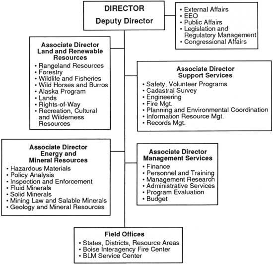
|
|
BLM organizational structure in 1987.
|
|
A DIRECTOR'S PERSPECTIVE:
1981-1989
by Robert F. Burford
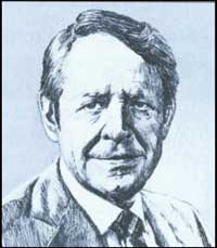
Robert F. Burford (Jennifer Reese)
|
Editor's Note: Robert Burford graduated from the
Colorado School of Mines in 1944. He has worked as a mining engineer and has
operated sheep and cattle ranches in northwest Colorado. He served three
terms in the Colorado House of Representatives from 1974 to 1980, and
was elected Speaker in 1979, before being selected as Director by
President Reagan.
It has certainly been a privilege to serve as the
Director of BLM during the Reagan Administration. Not to sound
prematurely nostalgic, but I carry many fond memories of the experiences
and the friendships derived from my tenure. I cannot take credit for all
Bureau accomplishments while I have been Director—a great number were pent-up
ideas of BLM career professionals that had gone long unimplemented. On
that count, BLM could not have reached its goals without the creativity
and dedication of its employees or from the cooperation of the public
lands users of the '80s.
I do, however, take pride in seeing that BLM was set
back on track. I was perhaps a bit more than a pacifist in the movement
termed the "Sagebrush Rebellion." When I first came to Washington, our
public lands were being managed, not as belonging to all the taxpayers
of this nation, but more along the lines of private playgrounds for a
number of special interests. The primary concern was the preservation of
those playgrounds.
Lost had been the leadership to carry out BLM's
mission to manage the public lands for a multiplicity of uses, not just
a single use. The foundation for that mandate, the Federal Land Policy
and Management Act (FLPMA), tells us to base our management of the
public lands on this concept and on the principle of sustained yield.
So, while our stewardship of the public lands includes protection of
wildlife habitat, cultural ruins and federal wilderness areas, these
BLM-managed lands yield a rich bounty of timber, and livestock forage,
plus significant deposits of oil, gas, coal, and other energy
minerals.
Given BLM's jurisdiction over 270 million acres
(about 46 percent of the federally-owned lands), that's a big job. There
will always be a bit of one-upmanship, I imagine, between all the
different users of the public lands—whether it's ranchers, hunters,
oil riggers, backpackers, river rafters, or hardrock miners. They each
think their use as always the most important one offered by our public
lands. The magnitude and value of the public land resources inevitably
lead to conflicting demands by the many users of the public lands.
The FLPMA mandate for multiple-use management is
BLM's most powerful tool for reconciling these demands and viewpoints
about how the public lands are to be administered. It would be a
travesty for BLM to become a single-focus organization like the Park
Service or the U.S. Fish and Wildlife Service. It's a balancing act to
be sure, but while difficult, multiple-use provides enormous results for
the nation. In 1987, for instance, BLM oversaw a leasing program that
produced 148 million barrels of oil from public lands; yet, on the
other hand, we designated new, more sensitive lands as
Areas of Critical Environmental Concern (ACECs) that now total 5.1
million acres.
I set as my major goal a return to our congressional
multiple use guidance. It was anticipated that with stricter attention
to multiple use, conflicting user interests and desires would increase.
To cope with this, I urged BLM employees to conduct their official
public service duties in a manner that could best be described as a "good
neighbor" approach. It was intended to place a greater emphasis and
sensitivity to our working relationships with state and local
governments and the public lands users themselves.
As I reflect upon past accomplishments, I have seen a
strong bond develop between BLM and the public land users. This
partnership has successfully reversed the lock-up trend of previous
administrations and returned control from the chosen few to local
governments that are more directly responsive to the public's needs.
One cooperative effort of which I am particularly
proud is in BLM's land use planning process, where I have seen a
dramatic improvement during the past eight years. BLM's resource
management plans are the blueprints for future management; they are
flexible and reflect the conditions of the land. Their effectiveness as
a management tool comes from the close working relationship BLM people
have established with public land users.
Another continuing challenge is automation. In the
past few years, we have made a good start on modernization and
automation—ALMRS, GIS, the Land Information System. The
modernization effort is going to have a huge impact on BLM's ability to
carry out its mission for many years to come. I hope the effort is
ingrained enough by the time I leave here that its own momentum will
carry it through the next administration, and the next one after
that.
The elevation of energy and minerals to be co-equal
with renewable resources was yet another key accomplishment. Our
objective was to get the responsibility for onshore oil and gas
operations moved from the former Geological Survey Conservation Division
into BLM. As a result, we gained the responsibility for both subsurface
and surface regulation. That was a good stroke for the land, and a good
stroke for government. It did not make much sense that BLM was
environmentally responsible for the surface of the land but not the
subsurface. The fact that we were able to convince a couple of former
Secretaries, James Watt and William Clark, that those two
responsibilities should be melded together was an organizational
coup.
In terms of personnel, feelings run deep and often
mixed on the presence of political appointees within the ranks of the
agency. Like it or not, this practice will continue to be a fact of life
in Washington. I feel that BLM has been aided by this infusion of
talent, men and women who brought with them different portfolios of
accomplishment, because, by and large, they have been a complement to
the careerist land manager's goals. Frankly, their presence will go far
to assure that the Bureau of the future does not become an inbred,
stagnant organization.
Will multiple use of the public lands survive? It
can, and it should, but it will take more work and a renewed commitment
from our elected officials. Multiple use, practiced wisely, is good for
all Americans. Public lands are for the public to utilize and to enjoy.
We have come too far to abandon our efforts now.
|
|
|
After considering the use of existing systems to
automate land and mineral record operations, BLM began developing the
Automated Land and Mineral Record System (ALMRS) in 1984. The Bureau's
Field Committee, composed of BLM Associate State Directors, is
supervising this effort. ALMRS became a presidential priority system in
1987, the same year BLM decided to "bundle" hardware and software
procurements with commercial off-the-shelf products rather than
designing a unique system. In 1988 BLM started a comprehensive
modernization study and began identifying system requirements to integrate ALMRS,
LIS, and other automated systems in the Bureau and to ensure that its
automation-related procurements will be well coordinated.
|
|
|
THE HUMAN RESOURCE DEVELOPMENT COMMITTEE AND ITS ROLE IN IMPLEMENTING
CHANGE IN THE BUREAU OF LAND MANAGEMENT
by Mike Evans
Management Services
The Human Resource Development Committee (HRDC) is an operating
subgroup of the Bureau Management Team (BMT). It is chartered to
recommend BLM policy and strategic direction to the BMT for employee
development and training, organization and management development, and
other human resource development activities.
The HRDC has three executive members that meet with managers and
employees from all organizational levels. This enables the members to
gain perspective and technical input, and it allows employees to
participate in the development of the policies that affect them.
The HRDC assists the BMT in improving workforce productivity,
competence, and morale by building and maintaining forward thinking,
evaluating existing policies and programs, and making recommendations
regarding change. The HRDC also provides guidance to Bureau HRD
officials and information to employees.
Most recently, the HRDC sponsored a major workshop that set in motion
many initiatives for further integrating the workforce through a special
focus on minorities and women; guided a major process to increase morale
and agency pride; and is sponsoring a comprehensive career development
program for all BLM managers and specialists.
The HRDC will continue to represent the collective commitment of the BMT
to human resource development, and it will continue to learn from all
BLM people in its pursuit of excellence in managing both natural and
human resources.
|
|
|
The results of this work should transform BLM.
According to ALMRS Project Manager Brian Bernard, in the mid-1990s a
typical Bureau field office will do the same work it has always
done—manage resources, process right-of-way applications, examine
mining claims, and so forth. However, the tools it uses to do the job
will be different. Computers and terminals will be used as commonly as
they are today in banks and libraries. The result will be more time for
employees to spend with individual members of the public and for
on-the-ground field work, with less time spent locating case files or
tracking down reports.
|
|
|
CONCLUSION
|
|
|
Public land management has become an increasingly
complex science—and it will likely remain so. But despite BLM's
increasing "procedural" requirements, land management remains an art as
much as it is a science. Administrations, manuals, systems, and
reorganizations have come and gone, but the role of individual employees
in getting BLM's work done is as critical as ever.
The Bureau of Land Management today employs people in
197 occupational series—out of a total of 620 in the entire federal
government. The growth and diversification of BLM's workforce is a good
indicator of the responsibilities the Bureau has gained in serving the
American public. Now that we have secured a mission—with a firm
commitment to multiple use management of the public lands—we must
implement the vision.
The Bureau values its traditions and values its
employees. There have been plenty of challenges and controversies on the
public lands since 1785, with battles won and lost, depending on your
perspective, and more are yet to come. But opportunity also
remains—for BLM employees, land users, and the American public at
large, working together to manage the public lands for multiple use. And
that's what makes the experience exciting and worthwhile. BLM's unique
values have developed from its unique history. An example of these
values can be found from a page taken from the recently completed
strategic plan for the Bureau's recreation program, Recreation
2000:
INNOVATIVE PUBLIC LAND MANAGEMENT
We are proud of what BLM people have accomplished over the years.
However, we encourage each of you to recommend and try new ideas and
options to meet the challenges of the future.... Our organization can
develop innovation through people by
— establishing an
environment within the organization that supports creativity;
— rewarding and recognizing employees who have
implemented unique and successful programs or developed unusual
approaches to the solution of problems;
— showing employees a willingness to invest in their
future—a concern for them on a personal basis;
— encouraging experimentation while discouraging the
attitude that it "cannot be done;"
— developing an attitude in managers of encouragement
of employees to try new ideas or different directions in management styles;
— implementing a "bottoms-up" style of
management—where all are encouraged to contribute and
participate;
— establishing procedures and policies that break
down the bureaucratic tendency to stifle creativity;
— developing a policy that looks toward the future
and at long term solutions to potential or real problems; and
— continually appraising and reappraising the
direction and impact of policies with an eye on creative change to
correct areas of concern.
We encourage managers and all employees to think,
act, stimulate, encourage, and reward creativity, freedom of expression
and the willingness to "give it a try."
Individual employees in the Bureau of Land Management
and its predecessor agencies have clearly made a difference in getting
things done on the public lands. This will remain true in the future.
How we do our jobs influences millions of Americans.
BLM's history is America's history. How Americans
view their public lands is reflected in the Bureau's evolving mission.
Our history can and should be used as a guide to the future. History
does repeat itself, and with this awareness, we should be well
prepared to meet the challenges of the future.
Public land issues that have shaped BLM in the past
will continue to influence our future. Major themes include:
development vs. preservation
multiple use vs. dominant use
states' rights vs. federal control
new programs vs. traditional uses
Balancing the needs, uses, and wishes of the American
public on its lands is the Bureau's job. Working for BLM is exciting,
frustrating at times, and, ultimately, rewarding. We hope that you've
enjoyed this account of BLM's history and that you will be motivated to
learn more.
|
|
Bureau of Land Management
1946-1960
|
| Employees |
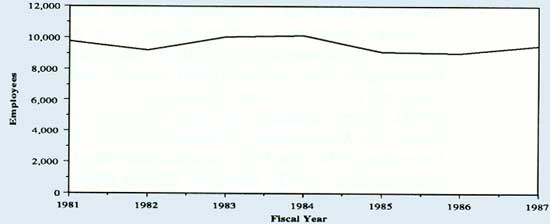 |
| Budget |
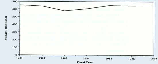 |
| Revenues |
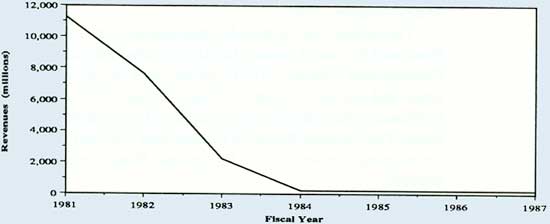 |
| Responsibility for offshore mineral leasing
was transferred from BLM to the Minerals Management Service (MMS) in 1982. This
leasing accounted for the bulk of the revenues until 1982 |
| Directors |
|
Major
Legislation |
| BLM-MMS Merger | 1982 |
| Federal Oil and Gas Royalty Management Act | 1982 |
|
|
|
|
FURTHER READINGS |
|
|
While it is too early for historical assessment of
BLM and public land policies in the 1980s, there is no shortage of
writings on the subject. Political scientists and natural resource
professionals are increasingly focusing their attention on BLM and its
administration of the public lands.
Books presenting collections of articles on public
land issues best illustrate the growing interest in BLM. Among the
available books, see Rethinking the Federal Lands (1984), edited by
Sterling Brubaker; Public Lands and the U.S. Economy: Balancing Conservation
and Development (1984), George Johnston and Peter Emerson, editors;
Western Public Lands: The Management of Natural Resources in a time
of Declining Federalism (1984) John Francis and Richard
Ganzel, editors; Land Reform, American Style (1983), edited by Charles Geisler
and Frank Popper; Federal Lands Policy (1987) Philip O. Foss,
editor; and The Public Lands During the Remainder of the Twentieth Century:
Planning, Law and Policy in the Federal Land Agencies (1987), by the
University of Colorado's Natural Resources Law Center.
Books that talk about the public lands and their
values include This Landis Your Land: The Struggle to Save America's
Public Lands (1984) by Bernard Shanks; Lands of Brighter Destiny: The
Public Lands of the American West (1986) Elizabeth Darby Junkin;
These American Lands: Parks, Wilderness, and the Public Lands (1986),
Dyan Zaslowsky and the Wilderness Society; and The Kingdom in the
Country (1987) by James Conaway.
Another book that deals with the public lands is
Sally K. Fairfax's and Carolyn Yale's Federal Lands: A Guide to Planning,
Management, and State Revenues (1987).
The debate that surrounded management of federal
grazing policy is illustrated by Gary Libecap, Locking Up the Federal
Range: Federal Land Controls and Graziers (1981), which calls for
privatization of the public lands, and Sacred Cows at the Public
Trough (1983) by Denzel and Nancy Ferguson, which decries the
influence of stockraisers who use the public range. The National
Research Council and National Academy of Sciences' Developing
Strategies for Rangeland Management (1984) is also of interest.
BLM wildlife management is addressed in the
Audubon Wildlife Report of 1987 (1987), edited by Roger L. DiSilvestro,
William J. Chandler, and Katherine Barton.
Mineral policy in the early 1980s is handled by
Robert Nelson in his The Making of Federal Coal Policy (1983). A book
critical of federal mineral policy and advocating reform is Public
Domain—Private Dominion: A History of Public Mineral Policy in America
(1985) by Carl Mayer and George Riley.
On Alaskan issues, see Frank Willis', Do Things Right the First
Time: The National Park Service and the Alaska National Interest Lands
Conservation Act of 1980 (1985). Gary Stein discusses the Alaska
state land selection program in "Promised Land": A History of Alaska's Selection
of Its Congressional Land Grants (1987).
|
chap5.htm
Last Updated: 08-Sep-2008
|