|
Bryce Canyon National Park Utah |
|
 NPS photo | |
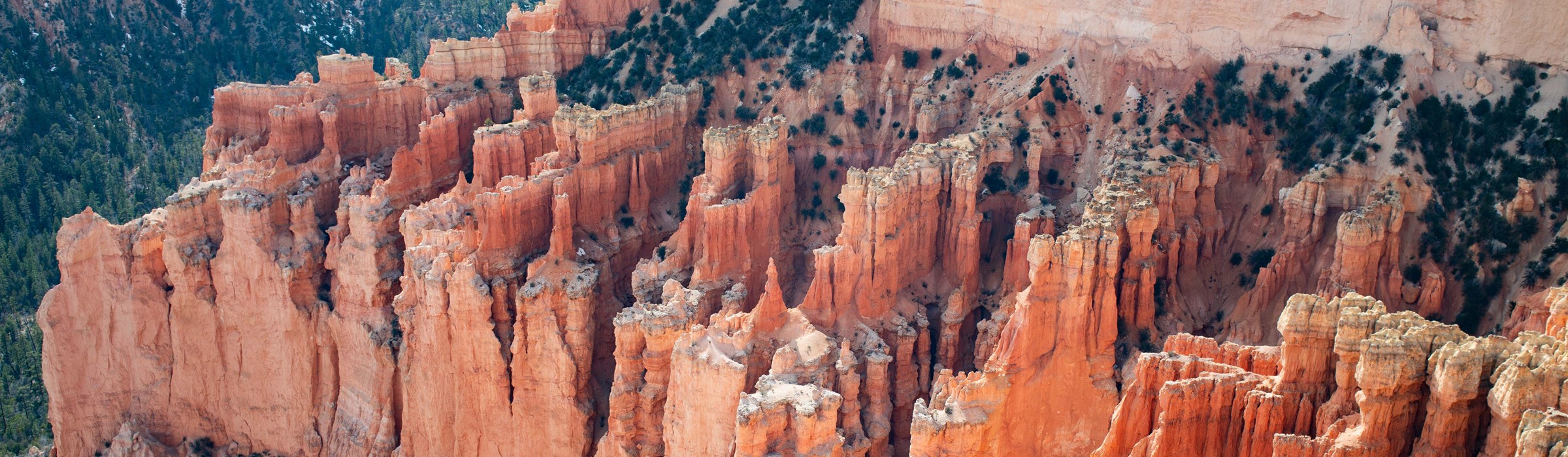
Poetry in Stone
Bryce Canyon's serene vistas are deceptive; the landscape is never static. Stand at the rim in early morning and experience the chilly dawn, crystalline blue sky, and rocks ablaze with the ruddy light of sunrise. After breakfast, walk the rim and your shifting perspective dramatically recomposes the scene below. The Sun arcing across the sky casts a kaleidoscope of slowly altered hues and shifting shadows over the land. You peel off layers of clothing as the air rapidly warms—as much as 40°F from dawn to late afternoon. Thin air can leave you short of breath. The high elevation that causes these effects also creates the climate that weathers the cliffs and bulbous columns called hoodoos. After sunset, as the chill returns, listen through the advancing twilight for the faint clatter or murmur of the stones tumbling in the distance. At Bryce Canyon the forces of weathering and erosion never rest, not even for a day. This dynamic, mesmerizing place is like no other.
HOODOO FORMATION Hoodoos don't grow like trees but are eroded out of the cliffs where rows of narrow walls form. These thin walls of rock are called fins. Frost-wedging enlarges cracks in the fins, creating holes or windows. As windows grow, their tops eventually collapse, leaving a column. Rain further dissolves and sculpts these limestone pillars into bulbous spires called hoodoos. The delicate climatic balance between snow and rain ensures that new hoodoos will emerge while others become reduced to lumps of clay.
Geology of Bryce Canyon
LIVES OF THE HOODOOS
Weathering and erosion shape these statuesque rock features, but unlike
many places, flowing water only plays a minor role in this story. As
snow and ice melt, water seeps into fractures. As it re-freezes, it
expands and cracks the rock around it. This common process of
frost-wedging happens with uncommon frequency at Bryce Canyon.
About 180 days a year temperatures swing widely between freezing nights and warm afternoons. The combination of gravity and meltwater causes soil creep, moving the stone fragments downhill. Rain from summer thunderstorms further dissolves the limestone into a clay ooze and generates just enough flowing water to help remove the debris.
Before this area was full of hoodoos it was full of water. Between 55 and 40 million years ago (mya), today's Utah was a mountain-encircled basin. For millions of years, rivers deposited sediments—mostly dissolved limestone—into a system of large lakes. Twenty million years ago, as the Colorado Plateau began to rise, the lakes dried up and their mixtures of sediments became the muddy limestone called the Claron Formation.
An inland sea that divided the continent east-to-west 90 mya deposited sediments that formed the oldest rocks in the park. They lie unseen now below the Claron Formation that formed from 55 to 35 mya by sedimentation in large lakes that waxed and waned in the region.
Massive tectonic plate activity from 20 to 15 mya began to push up a tremendous swath of Earth's crust. This eventually raised the region nearly two miles, to form the 130,000-square-mile Colorado Plateau.
STEPS THROUGH TIME
Layers in rock are like the chapters in a huge history book that
describe how Earth developed. Where can you read the only unabridged
edition of the planet's history? Right here.
The Grand Staircase is the world's most complete sequence of sedimentary rocks—rocks formed over vast timespans from sediments built up in lakes, inland seas, swamps, deserts, and forests. From Grand Canyon at the bottom, through Zion National Park in the middle, to Bryce Canyon National Park near the top of the staircase, this rock record recounts a history of 525 million years.
Elsewhere on Earth the geological sequences have been interrupted by uplift of mountain ranges or carving and scouring action by glaciers. In the Grand Staircase, however, very few gaps mar the sequence. Most chapters and even pages of this book are still intact. This does not mean you can stop just anywhere along the 100-mlle-long Grand Staircase and see all 525 million years of this history. Earth's curvature would not let you do that.
The exposed cliff faces of the tilted rock formations suggested the staircase metaphor. The pink cliffs at Bryce Canyon are the top step of the staircase.
  (click for larger map) |
Wildlife at Bryce
Watchful eyes and good luck may reward you with wildlife sightings. Mountain lions and Great Basin rattlesnakes are secretive and not often seen. White-throated swift nests blend with the red rocks—but look up on Wall Street and you may spot them. Violet-green swallows wait out spring cold snaps by slowing their fast metabolism. Utah prairie dogs were listed as an endangered species in 1973, but protecting both them and their habitat improved their situation; in 1994 they were listed as a threatened species.
STARRY NIGHT
High elevation, clean dry air, and lack of light pollution make Bryce Canyon one of Earth's darkest places. With our Dark Rangers' help, Bryce Canyon offers you ultimate stargazing. High-quality darkness is ablaze with starlight. On moonless nights the Milky Way looks like a huge silvery rainbow from horizon to horizon. Venus and Jupiter are so bright they create shadows.
Powerful telescopes reveal the new stars inside nursery nebulae, shock waves from exploded stars, and ancient globular clusters seem like diamonds on black velvet. Millions of light years beyond, but reached by our telescopes, other galaxies of all shapes and sizes inspire the imagination. Making the most of a bright full moon, our Dark Rangers offer guided night-hikes among the moonlit hoodoos. Bryce Canyon is the perfect place to see why astronomy fascinates so many people. Use our website to plan your stellar visit.
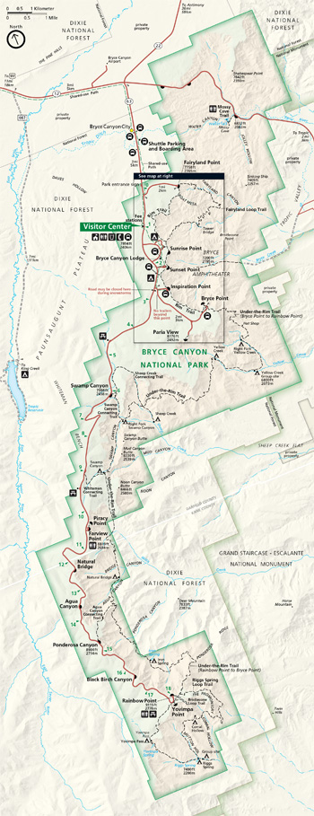
EXPLORING BRYCE CANYON
VISITOR CENTER Start here for information, exhibits, a movie, publications, backcountry permits, and emergency services. Open daily; closed Thanksgiving, December 25, and January 1, with longer hours April to October. The park road follows the plateau rim for much of its 18 miles. In summer free shuttle buses serve the most popular facilities and overlooks. For hours, activities, and programs contact the. park at www.nps.gov/brca or 435-834-5322.
INTERPRETIVE PROGRAMS Rangers offer talks, evening programs, and guided walks year-round. Topics range from geology and wildlife to astronomy. Check at the visitor center for the full range of programs.
LODGING AND TOURS For information about the lodge visit www.brycecanyonforever.com or call 435-834-8700., Year-round lodging is offered nearby. Sign up for horseback tours at the lodge or contact Canyon Trail Rides; www.canyonrides.com.
CAMPING Over 200 sites (tent and RV, fee) at North and Sunset campgrounds are mostly first-come, first-served, with water and restrooms nearby. At North Campground 13 RV sites can be reserved. At Sunset Campground 20 tent sites and one group site can be reserved. To reserve a site contact www.recreation.gov. Bring or buy firewood; gathering wood in the park is prohibited. No hookups. An RV dump station (fee) is near North Campground in summer. A store near Sunrise Point parking area sells food and supplies April to November and has coin-operated shower and laundry facilities.
WALKING AND HIKING Over 65 miles of hiking trails offer close encounters with hoodoos. Trails start from overlooks along the main park road. Get details at the visitor center. Carry drinking water; wear hiking boots, and remember—your return is uphill! Overnight backpacking is allowed on the Under-the-Rim and Riggs Spring Loop trails only. Permits are required for overnight backcountry use (fee) and are available af the visitor center. Make reservations, in person only, at the visitor center up to 48 hours before your trip. Visit www.nps.gov/brca/planyourvisit/backcountryinfo.htm for important current regulations.
WEATHER From April through October days are pleasant, nights cool. Thunderstorms are common in summer. Winter days are brisk and bright. Most overlooks are open in winter.
ACCESSIBILITY We strive to make facilities, services, and programs accessible to all. Buildings, restrooms, many viewpoints, and the trail between Sunset and Sunrise points are wheelchair-accessible. Accessible campsites are available in summer. Service animals are welcome.
FOR YOUR SAFETY Steep drop-offs abound here; watch children closely and stay back from cliff edges. • High elevations can be dangerous if you have heart or respiratory ailments. Know your limits—don't overexert! • Wear hiking boots and watch your footing. • During thunderstorms stay in your vehicle; avoid trees and open areas. • Obey posted speed limits. Drivers: Be alert for animals, especially after dark.
REGULATIONS Pets must-be attended and leashed. They are allowed on all PAVED surfaces—including overlooks and the trail between Sunset and Sunrise points—and in campsites and picnic areas. Pets are not allowed on any unpaved trails or in public buildings. • Camp in designated campgrounds; build fires in grills; and picnic at designated picnic areas. • Stay on trails; don't take shortcuts. Yield to horse traffic. • All plants, animals, rocks, and cultural objects are protected by federal law. • For firearms regulations see the park website. • Hunting and trapping are prohibited. • All wheeled vehicles, even bicycles, must stay on paved roads.
EMERGENCIES: Call 911 or the Garfield County Sheriff's office.
Source: NPS Brochure (2016)
|
Establishment
Bryce Canyon National Park — September 15, 1928 (established) |
For More Information Please Visit The  OFFICIAL NPS WEBSITE |
Documents
Annotated Checklist of Vascular Flora, Bryce Canyon National Park NPS Natural Resource Technical Report NPS/NCPN/NRTR-2009/153 (Walter Fertig and Sarah Topp, January 2009)
Birds of Zion, Bryce, and Cedar Breaks Zion-Bryce Museum Bulletin No. 5 (Russell K. Grater, Zion-Bryce Natural History Association, March 1947)
Bristlecone Pine Nature Notes (Vol. 1 No. 1, undated)
Bryce Canyon National Park: A Geologic and Geographic Sketch Zion-Bryce Museum Bulletin No. 4 (Zion-Bryce Natural History Association, June 1941)
Bryce Canyon National Park: Archeology of the Paunsaugunt Plateau Intermountain Cultural Resources Management Professional Paper No. 69 (Chris T. Wenker, ed., 2004)
Cultural Landscape Report, Old NPS Housing and Bryce Canyon Lodge, Bryce Canyon National Park (Lauri MacMillan-Johnson and R. Brooks Jeffrey, eds., December 2008)
Cultural Landscapes Inventory: Bryce Canyon Lodge/Deluxe Cabins (2010)
Evaluation of Quality-Control Data and Quality Assurance for Routine Water Quality Monitoring: Bryce Canyon, Capitol Reef, and Zion National Parks, Water Years 2006–2013 NPS Natural Resource Report NPS/NCPN/NRR—2016/1154 (Rebecca H. Weissinger, March 2016)
Finding Aid: Cultural Resources Records, Bryce Canyon National Park (February 2015)
Foundation Document, Bryce Canyon National Park, Utah (May 2014)
Foundation Document Overview, Bryce Canyon National Park, Utah (June 2014)
General Management Plan/Development Concept Plan: Bryce Canyon National Park, Utah (1987)
Geologic Resource Evaluation Report, Bryce Canyon National Park NPS Natural Resource Report NPS/NRPC/GRD/NRR-2005/002 (T.L. Thornberry-Ehrlich, September 2005)
Ground-Water Resources of the Bryce Canyon National Park, Utah USGS Water-Supply Paper 1475-M (1963)
Historic Aspen Dendroglyph Documentation Project, Bryce Canyon National Park (Sue Eininger and Chris T. Wenker, 2002)
Historic Resource Study: Bryce Canyon National Park (HTML edition) (Nicholas Scrattish, September 1985)
Historic Structure Preservation Guide for Bryce Canyon Lodge, Bryce Canyon National Park: Volume 1 — General Instructions Draft (September 1991)
Historic Structure Report: Utah Parks Company Service Station, Bryce Canyon National Park (Preservation Studies Program, The University of Arizona, November 2005)
Historic Structures Report: Old Housing Historic District, Bryce Canyon National Park, Utah (Center for Cultural Sustainability, The University of Texas at San Antonio, c2016)
Junior Ranger Activity Book (Ages 3-5), Bryce Canyon National Park (2017; for reference purposes only)
Junior Ranger Activity Book (Ages 6 and up), Bryce Canyon National Park (2017; for reference purposes only)
Bryce Canyon National Park Junior Ranger Field Book (Date Unknown; for reference purposes only)
Landscape Phenology, Vegetation Condition, ,and Relations with Climate at Bryce Canyon National Park: 2000-2019 NPS Science Report NPS/SR-2024/189 (David Thoma, September 2024)
Mammals of Zion-Bryce and Cedar Breaks Zion-Bryce Museum Bulletin No. 2 (C.C. Presnall, Zion-Bryce Natural History Association, January 1938)
Multimodal Transportation Plan Environmental Assessment, Bryce Canyon National Park (February 2014)
Multi-use Visitor Path Environmental Assessment, Bryce Canyon National Park (September 2014)
National Register of Historic Places Nomination Forms
Bryce Canyon Lodge and deluxe Cabins (Laura Soulliere Harrison, 1985)
Bryce Canyon Lodge Historic District (Janene Caywood, December 31, 1994)
Bryce Canyon National Park Multiple Property Submission (Janene Caywood, December 31, 1994)
Bryce Canyon National Park Scenic Trails Historic District (Janene Caywood, December 31, 1994)
Bryce Inn (Janene Caywood, December 31, 1994)
Horse Barn (Janene Caywood, December 31, 1994)
Loop C Comfort Station (Janene Caywood, December 31, 1994)
Loop D Comfort Station (Janene Caywood, December 31, 1994)
Old Administration Building (Janene Caywood, December 31, 1994)
Old National Park Service Housing Historic District (Janene Caywood, December 31, 1994)
Rainbow Point Comfort Station and Overlook Shelter (Janene Caywood, December 31, 1994)
Riggs Spring Fire Trail (Janene Caywood, December 31, 1994)
Under-the-Rim Trail (Janene Caywood, December 31, 1994)
Utah Parks Company Service Station (Janene Caywood, December 31, 1994)
Natural Resource Condition Assessment, Bryce Canyon National Park NPS Natural Resource Report NPS/NCPN/NRR-2018/1690 (Lisa Baril, Kimberly Struthers and Patricia Valentine-Darby, August 2018)
Nature & Nation: The Civilian Conservation Corps in Zion and Bryce Canyon National Parks (©Valerie Lynn Jacobson, Master's Thesis Utah State University, 2017)
Paleontological Resource Inventory (Public Version), Bryce Canyon National Park NPS Science Report NPS/SR-2024/123 (Tut Tran, Alexandra E. Bonham, Justin S. Tweet and Vincent L. Santucci, May 2024)
Park Newspaper (Hoodoo)
Summer: 1985 • 1987 • 1990 • 1991 • 1992 • 2003 • 2004 • 2006 • 2007 • 2009 • 2010 • 2011 • 2012 • 2013 • 2014 • 2015 • 2017
Winter: 2005-2006 • 2007-2008 • 2008-2009 • 2010-2011 • 2011-2012 • 2012-2013 • 2013-2014 • 2014-2015 • 2015-2016
2016 • NPS Centennial Edition (2016) • 2017 • Chinese • French • German • Italian • Japanese • Korean • Spanish
Park Newspaper (Visitor Guide)
2018 • 2019 • 2020 • A Century of Wonder (Centennial) • 2023 • 2024
Preliminary Results of Noise Monitoring in 1995 in Bryce Canyon National Park (Dan A. Foster and Richard M. Bryant, c1996)
Resource Management Plan, Bryce Canyon National Park (December 1996)
Restoration of Mixed Conifer Communities Using Prescribed Fire in Bryce Canyon National Park (Michael J. Jenkins, Christopher A. Dicus and Joel E. Godfrey, from Tall Timbers Fire Ecology Conference Proceeding, Vol. 20, 1998)
Spatial Patterns of Overflight at Bryce Canyon National Park, Updated 2023-2024 NPS Science Report NPS/SR-2025/242 (Tyra A. Olstad, Brian A. Peterson, J.M. Shawn Hutchinson, J. Adam Becco and Damon Joyce, February 2025)
Statement for Management — Bryce Canyon National Park (1983)
The Dixie National Forest: Managing an Alpine Forest in an Arid Setting (Wayne K. Hinton, 1987)
The Modern Discovery, Popularization, and Early Development of Bryce Canyon, Utah (Nick Scrattish, extract from Utah Historical Quarterly, Vol. 49 No. 4, 1981; ©Utah State Historical Society)
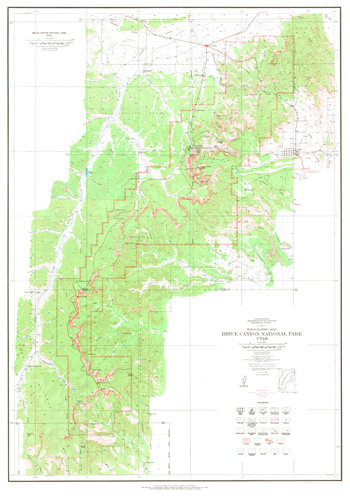
Topographic Map: Bryce Canyon National Park, UT Scale: 1:31,680 (USGS, 1972)
Trees of Zion and Bryce Canyon National Parks (1960)
Trends in Water Quality at Bryce Canyon National Park, Water Years 2006-2021 NPS Natural Resource Report NPS/NCPN/NRR-2022/2476 (Rebecca H. Weissinger, November 2022)
Vascular Plant Species Discoveries in the Northern Colorado Plateau Network: Update for 2008-2011 NPS Natural Resource Technical Report NPS/NCPN/NRTR-2012/582 (Walter Fertig, Sarah Topp, Mary Moran, Terri Hildebrand, Jeff Ott and Derrick Zobell, May 2012)
Visibility Research at Bryce Canyon (undated)
Zion-Bryce Nature Notes (1929-1936, 2009-2011)
ELEMENTS - A National Parks Documentary (Yellowstone, Grand Teton, Bryce, Zion)
brca/index.htm
Last Updated: 26-Feb-2025