|
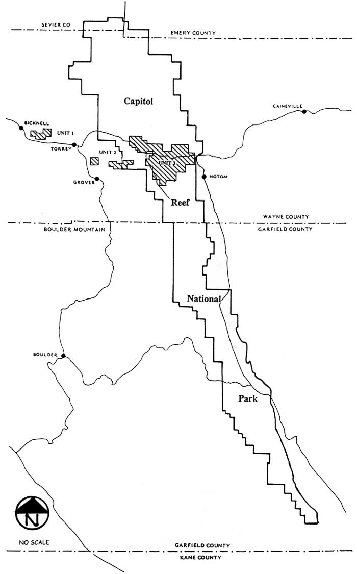
Capitol Reef
Administrative History |

|
CHAPTER 8:
THE ESTABLISHMENT OF CAPITOL REEF NATIONAL MONUMENT
Capitol Reef National Monument was established on August 2, 1937 by Franklin Roosevelt's presidential proclamation. The national recognition and protection of the Waterpocket Fold resulted from two decades of hard, persistent campaigning by local boosters before the National Park Service ever became involved. The original idea for a national park in Wayne County began with an eye to the rapidly developing Zion, Bryce Canyon, and Grand Canyon National Park areas, and the economic benefits accruing from them.
The Beginning Of An Idea
National Park Service Director Stephen Mather first visited southwestern Utah in November 1919, and was immediately enthralled with the scenery--and potential--of Zion and Bryce Canyon. In the same speech commenting on the vistas, he proclaimed the need for roads, lodges, and publicity. [1]
Mather's motivation for developing the southwestern Utah parks were clear. His national park system was still in its infancy, desperately competing with the U.S. Forest Service and other federal agencies for operating money from Congress. The more tourists that could be attracted to the parks, the more prestige and money would come to the National Park Service. At that time, the potential tourist was most likely well off and had the idle time needed to travel through the scenic West by rail and motor coach. These upper class visitors expected easy access and luxurious accommodations. So if Mather was to succeed in establishing the National Park Service as a powerful federal agency, he needed to work closely with private travel companies to insure smooth, enjoyable access to quality lodges within the parks. In turn, towns and businesses located near the parks would benefit from increased tourist dollars. [2]
Mather worked closely with both the Union Pacific Railroad and the Mormon Church to upgrade facilities in the southwestern parks. New, luxurious lodges were built at Zion, Bryce Canyon, and the north rim of the Grand Canyon. Coordinated train and bus service was established to insure easy, pleasurable travel between parks. [3] This kind of action is precisely what the civic boosters of Wayne County had in mind when they began publicizing Wayne Wonderland.
By the 1920s, one could drive all day over the rough road through eastern Wayne County without seeing another car, or even a house. The roads descending south from Emery County were no different, and the roads south over Boulder Mountain were virtually non-existent. To the south in Garfield County, the terrain was so rough that no road east from Escalante had yet been attempted. Boulder and the entire Circle Cliffs area were so isolated that the town holds the distinction of being the last place in the continental United States to get its mail by mule. In those days, few tourists would venture into this unknown region when they had the hard-surfaced roads and comfortable lodgings around Zion and Bryce Canyon National Parks. [4]
Needless to say, the local civic boosters had a lot of work ahead. If tourists were to be enticed to Wayne County, roads must be improved and lodgings built. It was thought that a national park encompassing some portion of the area between Torrey and Hanksville, known by locals as Wayne Wonderland, would offer the kind of scenery necessary to attract the National Park Service.
According to Anne Snow in her Rainbow Views history, national publicity for the wonders of Wayne County actually began in 1914 with the circulation of photographs of a natural bridge, later named Hickman Natural Bridge, just north of Fruita. Then in 1921, a local "Booster's Club" was organized to help publicize the area. The leaders of this club were Wayne High School Principal Joseph Hickman and his brother-in-law, Ephraim Pectol, who operated the Wayne Umpire grocery store in Torrey. Even though these men were highly respected in Wayne County, their initial efforts did not receive much support.
The 1920s were still a period of hard struggles and self sufficiency; there were few residents who could appreciate the slickrock desert country as anything more than a hard place to live in or travel through. Soon thereafter, Pectol and Hickman merged their group with the Richfield Chamber of Commerce, the Salina Lions Club, and the Wayne Commercial Club to create the Wayne Wonderland Club. Joseph Hickman became its first president. [5] As this civic interest continued to expand, a little more money was available to advertise the scenic beauty of "Wayne Wonderland," a title attributed to Ephraim Pectol. [6]
A State Park That Never Was
Attempts to recognize the scenic grandeur and tourist potential of Wayne Wonderland moved to the state level after Hickman was elected to the Utah State Legislature in 1924. During the 1925 session he succeeded in getting several bills passed, including one creating a Board of State Park Commissioners having the power
to cooperate with any Federal, or other, organization, having for its purpose the investigations of State Park possibilities within the state of Utah....If such findings disclose any areas of sufficient natural, historical, or lofty scenic quality as to justify such action, said board shall designate such areas as State Parks or State monuments...[and] said board is hereby empowered to acquire for and in the name of the State of Utah, any land within or comprising such designation; provided that said board shall have power to accept gifts from any county, municipality, individual, or the Federal Government of money or land.... [7]
Note that nowhere does the law mention any specific area to be considered for state park status. Local and official National Park Service histories have always assumed that Wayne Wonderland was the first state park in Utah, purportedly established in 1925. [8] Anne Snow writes that during "the 1925 session [Hickman] succeeded in having one hundred and sixty acres of public land near Fruita withdrawn for a state park." [9] Charles Kelly's numerous articles on the history of Capitol Reef National Monument also state that it was Hickman who was responsible for having a Wayne Wonderland State Park established in 1925 (although he uses the figure 16 acres, which is probably a typographical error). [10]
Due to a lack of documentation, such an assumption was easily made. One has to look at the actual dedication speeches to realize that the Wayne Wonderland State Park was not created in 1925. For example, when Utah Gov. George H. Dern arrived in Wayne County on July 19, 1925, he came only to celebrate
the gorgeous and awe-inspiring scenery in Wayne county that [was] destined to be made the first state park in accordance with the state park law added to [Utah's] statutes during the last legislature (emphasis added). [11]
This elaborate ceremony (Fig. 16) was planned by business and political leaders of Wayne, Sevier, and Sanpete Counties. Evidently, this ceremony was organized in hopes of encouraging future state and federal action (of which there had been none to date), rather than to be an actual state park dedication.

|
| Figure 16. Fruita School class with Gov. George Dern, 1925 |
The entire weekend of July 18-19 was set aside in Wayne County for the celebrations. A rodeo and dance were held on Saturday, with official festivities the following day. As many as 500 cars traveled together from Bicknell to Fruita, where a bower was set up to shade the participants. With the governor on the speaker's platform were Rep. Don B. Colton, representatives of the Mormon Church, and members of the various business clubs in the region. Interestingly, not a single representative of the National Park Service was there. [12]
Many of the speakers hoped for national recognition for Capitol Reef so that more tourist business would come to the area. Gov. Dern credited Joseph Hickman as the leader of the Wayne Wonderland movement. In his speech, Dern mentioned that Hickman introduced the bill for a board of park commissioners "because he had in his mind the creation of a state park in his own county." [13] Dern went on to speak of Hickman's attempts to get Wayne Wonderland recognized as the first state park. The previous April, the governor had come to Fruita as one of the new park commissioners, receiving a hearty welcome.
"I looked over the natural bridges and the rest of the scenery, including the pretty girls," the governor told his audience, "and was wonderfully impressed by what I saw." [14] Upon his return to Salt Lake City, Dern proposed that the other members of the board go down and take a look. He noted, " Some of them have been down here, whilst others have not been able to do so. It is hard to force action in a board that has not one cent of money to spend." [15]
Dern sympathized with the Wayne Wonderland boosters on their slow progress in getting state park status, and was quoted by reporters as saying:
I can't blame you for wanting some tourist business, and wanting it this year. It was therefore an enterprising move to organize this celebration to open Wayne Wonderland to the world in advance of its creation as a state park. I approve of your action and I hope we shall be able to bring about its actual designation as a state park before very long, and that it will be our first state park. [16]
Rep. Colton followed the governor to the podium to argue that the best advertisement for the state was for every person present to speak out for its beauty. Colton specifically praised Capitol Reef's scenery and mentioned his hopes for the future, proclaiming the area qualified for national park status. He said, "When the time comes and if the state park commission sees fit to request it, the national government will take hold of Wayne Wonderland." According to Colton, once a national park was created in Wayne County, "good roads not only within the park but to it" would follow. [17] After these "pre-dedication" ceremonies, everyone seems to have gone home in high spirits. They all seemed sure that the area was only a formal step away from state park and possibly national park status. The problem was, the legislature had not allocated any money for state parks at the time Hickman's bill was passed. As for national park status, no member of the National Park Service had yet come to Capitol Reef; in fact, no known correspondence prior to the early 1930s specifically asks the National Park Service to incorporate the area within its system. The campaign, thought to have been successful in July 1925, was only getting started.
Sadly, Wayne Wonderland soon lost its most active sponsor, Joseph Hickman, who drowned in Fish Lake less than a week after the celebration. Hickman, a well-liked and capable state legislator, could possibly have facilitated the process for state or national park status. After his death, the movement seems to have lost its momentum, which would not be regained for another five years.
As for Wayne Wonderland State Park, it never officially existed. An exhaustive search of the records by the author and state archivists has turned up little else on the ill-fated State Board of Park Commissioners. In his 1927 opening address to the legislature, Gov. Dern made brief mention of a new state parks movement, observing that scenic preservation was a worthy goal but cost a lot of money. The governor added that the board was considering two or three projects. "One such project," he said, "is now receiving serious attention and the matter of securing title to the lands is being investigated." [18]
If this project was Wayne Wonderland, that could explain Gov. Dern's informal withdrawal of 120 acres from section 13 of Township 29 South, Range 6 East in 1930. This section, in the heart of present Capitol Reef National Park, is directly east of Hickman Bridge and includes Capitol Dome. This withdrawal was later superseded by the August 1937 presidential proclamation establishing Capitol Reef National Monument. [19] In sum, Dern supported the idea of state parks, but was unwilling to advocate spending the money necessary for their acquisition and development.
There is some question regarding what other bills or resolutions Hickman saw through the legislature. Kelly reports in his biographical sketch of Hickman:
Mr. Hickman had introduced a resolution in the legislature asking the federal government to consider the possibilities of Wayne Wonderland as a national monument, realizing that the state would not have funds to properly develop the area. The resolution was duly sent to Washington for consideration....On July 27 (1925), three days later (after his death), word was received that the National Park Service would ask for withdrawal of the most scenic sections of Wayne Wonderland and investigate its possibilities for national monument status. [20]
There is no other record of this resolution. The federal withdrawal appears to have been a proposed Interior Department Power Reserve Site that was never acted upon.
Hickman's successor to the legislature, George C. Brinkerhoff, attempted to broaden the powers of the parks board, but failed to get past the Senate. [21] After that, no records can be found pertaining to any state parks for several years. The State Board of Park Commissioners became dormant due to lack of funding, and the designation of Wayne Wonderland as a state park died, as well. Even had Hickman lived, it is doubtful that the state legislature and governor would have been willing to spend the money necessary for state parks. [22]
The state park movement in Utah was not revived until the Utah State Planning Board began exploring recreational potential in the 1930s. By that time, the old territorial capitol at Fillmore had been set aside as a park, administered by the Utah State Historical Society. It was not until 1957 that the state legislature established the State Park and Recreation Commission, thereby creating a system of state parks in Utah. [23]
As for the land first proposed as Wayne Wonderland State Park, no boundaries were ever established. The land remained part of the enormous public domain, at that time controlled by the General Land Office (except for a few state sections set aside to raise money for Utah's schools).
After the death of Joseph Hickman, the new leader of the Wayne Wonderland boosters was his brother-in-law, Ephraim Pectol. Pectol became the key local representative responsible for the eventual creation of Capitol Reef National Monument.
Pectol operated a small store with rental cabins in Torrey, served as ward bishop from 1911 - 1926, and was clearly a recognized leader in Wayne County. His interest in archeology drove him to accumulate an impressive artifact collection that he exhibited in his "museum" at the store, to the envy and delight of visitors. Capitol Reef's first custodian, Charles Kelly, actually gained his initial exposure to the area during a trip to see Pectol's collection. [24]
In 1928, at Pectol's urging, the Wayne Wonderland Civics Club and Wayne County Commissioners paid photographer Dr. J. E. Broaddus $150 to take slides and give lectures throughout the state on the attractions of the Waterpocket Fold country. [25] About the same time, the campaign for Wayne Wonderland was absorbed by a new booster club representing the entire southwestern part of the state. By merging the various local and county booster clubs into the new Associated Civic Clubs of Southern Utah (ACCSU), the efforts to publicize Capitol Reef gained not only a more regional perspective but also a great deal of prestige and money. While this larger, better endowed business organization became a substantial voice, Ephraim Pectol continued to be the driving force for a national park within Wayne County. After the 1925 dedication, interest in state park designation receded as the focus of Pectol, the ACCSU, and state government shifted toward the loftier goal of national park status. [26]
The National Park Service Gets
Involved
The problem was that all these civic leaders had no idea what was involved in creating a national park. The lack of focus and direction in the drive for a Wayne Wonderland National Park is clearly exemplified in a meeting between Zion Superintendent Thomas J. Allen, Jr. and the Associated Civic Clubs of Southern Utah in July 1931. [27] This is the first serious, documented meeting between a National Park Service official and local leaders regarding Wayne Wonderland. (There is mention of Assistant Director Demaray visiting the area with Utah Rep. Louis C. Cramton several years earlier, but nothing seems to have come of that visit. [28]) Thus, despite the decade-long efforts of local and state officials, the National Park Service was not officially consulted regarding a national park for Wayne County until 1931. This is further substantiated by the fact that Wayne Wonderland was not on the list of official investigations of national park and monument projects in the summer of 1930. [29]
The purpose of that meeting in Loa between the civic leaders and Superintendent Allen was to tour the proposed area and evaluate whether it met the criteria to be considered worthy of national park or monument status. Allen explained the "high standards required for entrance of any area to the National Park System, and also defined the restrictions which would be necessary to place control of the area, possession of the lands by the Government, etc." [30] He also explained that any proposed area must be first officially investigated by the National Park Service and then authorized by either an act of Congress or a presidential proclamation.
It is not known if there were any ranchers in attendance, and if so, what their response was to Superintendent Allen's comments regarding restricted land use. The secretary of the Associated Civic Clubs, Benjamin Cameron, of Panguitch, presented a letter of support from Utah Sen. Reed Smoot stating "he would be glad at any time to introduce a bill in Congress for creation of a park in that area." [31]
The lack of understanding regarding National Park Service acquisition became clearer the next day as Allen and the civic leaders toured the area. After Allen viewed the Waterpocket Fold from Boulder Mountain and drove the roads in and around Fruita, he pronounced the area not "up to the standards of Zion," but worthy of official investigation. The impression he developed was that, while the people of Wayne County earnestly desired a national park, they were
really uninformed and in doubt as to just exactly what the whole proposition is about.... Certainly no definite plans or outline of procedure [had] been made, no information as to proposed areas was available, and no real organization for action was existing. [32]
It appears even from this first meeting between local park proponents and a National Park Service official that the two groups could perceive the same beautiful landscape differently. The National Park Service, represented by Superintendent Allen, and the local boosters, represented by Ephraim Pectol, both saw a potential national park. The difference was that, while Allen emphasized the need for specific boundaries and plans, Pectol and the others were more concerned with the urgent but more general hopes and dreams of local tourist promotion. These differences did not stop the two groups from working together to include Capitol Reef in the national park system.
As a result of this July 1931 meeting, the National Park Service became involved in the proposed Wayne Wonderland National Monument for the first time. On July 30, Allen wrote to Roger W. Toll, superintendent of Yellowstone National Park and also in charge of the official investigations into proposed National Park Service areas in the West. Allen reported his meeting and recommended, albeit with little enthusiasm, that Toll come take a look. [33]
Roger Toll was the perfect man for the job. A charter member of the Colorado Mountain Club and a graduate in engineering from Columbia University, Toll was first recruited for the park service in 1919 by Director Steven Mather. Starting out as superintendent of Mount Rainier National Park in Washington State, he rapidly rose through system. After a brief stint at his beloved Rocky Mountain National Park, Toll took over for Assistant Director Horace M. Albright as Yellowstone's superintendent in 1929. While at Yellowstone, Toll also assumed the responsibility of investigating all proposed western parks and monuments. [34]
Before Toll could investigate, the proposed park boundaries had to be clarified. At the end of July 1931, responding to newly appointed Director Albright's request, Allen submitted a copy of a road map of southern Utah to illustrate the approximate area in question. Allen did not mark any boundaries on the map, but used arrows to indicate the location of Fruita, and spots labeled "most scenic" (directly north of Fruita) and "suggested area" (slightly northwest of Fruita). [35]
This map gives a good indication of the continued isolation of southern Utah in 1930. While a key is not included, it is clear that Highway 24 from Sigurd, the only road through Wayne County, had been improved to a graded dirt road all the way through Capitol Gorge to Hanksville. Also present was another dirt road between Torrey and Grover that continued on to the west entrance to Capitol Gorge. The entire region south and east of Fruita and Escalante was devoid of any marked roads. This region's lack of access sharply contrasts with the impressive network of paved roads around Zion, Bryce Canyon, Cedar Breaks, and north toward Salt Lake along the old Mormon Corridor. [36]
By October 1931, the ACCSU reported that the "Wayne County people" (presumably, Pectol) had defined their proposed park area and had sent Director Albright a description. [37] On November 30, Superintendent Allen received a letter from Benjamin Cameron, secretary-treasurer of the ACCSU, stating that "the proposed National Park in the Wayne Wonderland...include[d] the area near Fruita as you approach it from the West, also that to the east and down the River gorge." [38] This general description puts the first proposed boundaries for a Wayne Wonderland National Park close to where the actual monument was later established, except for the cliffs, knobs and canyons south of Capitol Gorge to the Wayne-Garfield county line.
With this new information, Roger Toll set out the following October to make a preliminary visit to Wayne Wonderland, while also investigating Cedar Breaks and the San Rafael Swell for possible park or monument status. [39] In his November 8, 1932 report, Toll mentions a wide variety of resources, including archeology, paleontology, and geology. His overall impression is guardedly optimistic about potential inclusion into the national park system. Toll wrote:
[I]t impresses one as being only a little below the standard of existing national parks. If a number of new parks were to be created, this might easily be selected as one of them. On the other hand, it does not have any one distinctive feature that is superlative....The area seems worthy of future investigation. It would take a week or two to cover it satisfactorily. [40]
While the next five years of work toward monument status would be painfully slow but fairly smooth, opposition to the national park-building process was growing in southern Utah. Civic leaders still hoped that national parks and monuments would bring roads and tourists, as reported by Toll in 1932. [41] Zion, Bryce Canyon, and the north rim of the Grand Canyon were indeed drawing development and money to those areas. But increasingly, resistance upwelled from multiple-use proponents and state officials concerned with possible land-use restrictions in the midst of a deepening economic depression. Trouble would first surface over the plan to incorporate Cedar Breaks into the National Park Service. The struggle over Cedar Breaks provides some perspective to the park service's role in Utah during the 1930s.
Cedar Breaks And The Beginning Of
Opposition
From the creation of the National Park Service in 1916, its first director, Stephen Mather, had followed a consistent policy of national park and monument expansion. As mentioned earlier, this was motivated not only by the desire to protect the nation's scenic wonders, but also by the need for congressional acceptance and to gain an edge in funding competition with the forest service. Mather's successors, Horace Albright (1929-33) and Arno B. Cammerer (1933-40) continued this policy with even greater success. A total of 36 new national parks and monuments were created between 1929 and the time of Capitol Reef's proclamation in August 1937. Another 15 national monuments previously administered by the forest service, together with 44 historic sites administered by the War Department and other federal agencies, were added to the service through the federal reorganization acts of 1933. Official investigations and considerations of Capitol Reef as a worthy addition to the National Park Service were undertaken while the national park system was doubling the number of areas it administered. [42]
The state of Utah was one of those most affected by this growth. After Bryce Canyon joined Zion as a national park in 1928, Arches National Monument was created in April of the next year. Timpanogos Cave was acquired from the forest service following reorganization in 1933, and Cedar Breaks was added within the month. Zion National Monument protected the Kolob Canyon area in early 1937, and Dinosaur National Monument was also significantly expanded. [43]
While civic boosters of southern Utah favored adding national parks or monuments to publicize the state's beauty and bolster local economies, multiple-use advocates vehemently opposed adding any changes that could affect their livelihood. Park service plans to acquire the small Cedar Breaks area north of Zion and almost the entire Colorado River canyon network during the early 1930s were perceived as just such a threat. Accordingly, these plans faced rigid opposition from local, state, and federal officials, alike.
An initial clue to this growing antagonism was the reaction to Albright's suggestion in 1931 that Kolob Canyon, adjoining Zion National Park to the northwest, be made into a new national park. Both Gov. George Dern and Sen. William H. King opposed this idea on the grounds that stock growers needed much of the land for grazing. [44]
That same year, Cedar Breaks was proposed by the National Park Service as a detached addition to either Zion or Bryce Canyon National Parks. Cedar Breaks is a natural amphitheater with spectacular erosional features, very similar to Bryce Canyon but at a higher elevation. Stephen Mather had already identified the area in 1919 as part of the network of southwestern parks and, at his urging, a lodge had been built close to the amphitheater rim by the Union Pacific Railroad. Opposition to this proposal came swiftly from the U.S. Forest Service, which managed the land in question. The ensuing battle was a classic confrontation between the National Park Service and the U.S. Forest Service over territory and influence. These battles, as in this case, were usually won by the National Park Service. Often overlooked in these federal power struggles were the opinions of local residents. The dispute over Cedar Breaks revealed Utah's first clear and vocal opposition to a proposed national park. [45]
In open meetings at nearby Cedar City and Parowan, the local land users stood in solid opposition to the National Park Service taking over even a small section of land. Hal Rothman, the dispute's historian, later observed:
Although the clearly defined NPS acquisition effort at Cedar Breaks did not pose a real threat, the implications of such a transfer frightened local livestock interests. As long as the Forest Service could convince area residents that Cedar Breaks was only a prelude to further acquisition attempts, NPS claims of merit went unheard. [46]
Even the Associated Civic Clubs of Southern Utah, which supported the Wayne Wonderland proposal, wrote letters opposing this National Park Service plan. While many businessmen could appreciate the increased tourism that a national park would bring to the area, they could not afford to antagonize ranching neighbors who supported their businesses. So, while many privately supported a national park in the area, they publicly opposed it or tried to reach a workable compromise. [47]
In the end, the struggle over Cedar Breaks was decided among officials of the National Park Service and U.S. Forest Service in Washington, D.C. The forest service tried defending its turf by arguing that it, too, could manage an area for recreational and educational purposes; but in the end, the political clout of the National Park Service prevailed. The reorganization implemented August 10, 1933 effectively took the Forest Service out of the national monument picture and thus made much of the issue moot. With opposition at the federal level gone, Cedar Breaks was created as a small national monument by presidential proclamation two weeks later. Not adequately resolved, though, was the opposition of local land users. [48]
This resistance to National Park Service expansion would emerge again at Capitol Reef. In fact, the reason the area was initially set aside as a monument as opposed to a congressionally approved national park can be traced largely to opposition by stockmen.
Wayne Wonderland To Capitol Reef,
1933-1936
The campaign for Wayne Wonderland in the early 1930s seems to have taken a back seat to the struggle for Cedar Breaks, but this probably had to do with Roger Toll's busy schedule. Before Toll's next visit to Capitol Reef in November 1933, there was a considerable amount of maneuvering both in support and opposition to the proposed national park.
Ephraim Pectol was now the Wayne County representative to the Utah Legislature. Through his efforts, a memorial resolution was passed urging quick action on a Wayne Wonderland national park or monument. Signed by Gov. Henry Hooper Blood on March 15, 1933, the resolution to Congress is the first document detailing the area's proposed boundaries and the motives behind local support for Capitol Reef. [49]
The resolution, passed unanimously by the House, urged that the "scenic, archeological and geological value" of the area, "pronounced worthy" by "competent authorities," could be "brought to the attention of the American people only by having them set apart and designated as a national park or a national monument." This resolution marks the first time that a national monument was considered by promoters to be as acceptable as a national park. This may have been as result of the investigations of Allen and Toll the previous two years, or it may simply have shown the flexibility of supporters desiring any kind of federal designation for the area. The second part of the resolution combined the creation of a national park or monument with the hopes for "future highway construction" that would connect a "chain of natural wonders" from Mesa Verde and Natural Bridges to Bryce Canyon, Zion and Cedar Breaks. [50]
The connection of a Wayne Wonderland park with future highways has been evident since the first promotions a decade earlier. Local and state interest in this national park or monument clearly was overwhelmingly motivated by a desire for economic benefits that a tourist boom would bring to the area. This desire was particularly understandable, considering that these events occurred in the depths of the Great Depression. According to the Richfield Reaper:
The creation of a national monument in Wayne County is regarded as the first step toward completing an east-west highway across southern Utah...Such a route would provide an all-winter auto highway from Texas and other states in the southwest and south into southern California, and would also open up a new line of travel for the remainder of the year to tourists who seek opportunity to visit the newer wonderlands of Utah. [51]
The boundaries as proposed in the 1933 resolution were most likely drawn by Rep. Pectol. Three separate units were proposed: Unit 1 would encompass Velvet Ridge, the colorful bands of Chinle exposed above the Mummy Cliffs between Bicknell and Torrey; Unit 2 would protect the archeological and scenic features within the Fremont River corridor west of Fruita; and the boundary of Unit 3, the heart of new park, took in the lands from Chimney Rock Mesa north of the approach highway, east through Longleaf Flat to the Navajo Sandstone Domes and perhaps as far as Hickman Bridge and Capitol Dome. The line was south of Spring Canyon. From Capitol Dome, the boundary went south, which would have protected only the western rim of the cliff line as far Grand Wash, and then it jogged southeast to include the slickrock domes around Fern's Nipple. Only the western entrance to Grand Wash was included. The western line of Unit 3 would have enclosed only about one mile of the road to Capitol Gorge (at the entrance to Grand Wash) and would have skirted around the private lands of Fruita. In general, the Unit 3 boundaries would have included just the northern and eastern cliff rim, including the Navajo Knobs and Cohab Canyon, plus the scenic heart of the Fremont River canyon as far as Capitol Dome. In its gerrymandering around the private lands of Fruita, the resolution appears to have omitted Hickman Bridge. This proposal also left out the Grand Wash narrows and Capitol Gorge (Fig. 17). [52]
|
| Figure 17. 1933 monument boundaries, as proposed by Utah State Legislature. (click on image for an enlargement in a new window) |
No documentation has been found justifying the proposed boundaries or indicating influence by economic concerns. Except for small areas near the Fremont River corridor and the Longleaf Flats area just north of Fruita, all the proposed land was free of traditional grazing use. Apparently, Pectol had wanted to include the upper Pleasant Creek drainages west of the Waterpocket Fold, but this idea was dropped in response to objections by stockmen. [53] The reason for excluding Fruita was obvious.
Pectol wrote to Director Albright informing him of the resolution and the desire for action. Albright responded with cautious encouragement. The director noted that he had heard "very fine reports on the Wayne Wonderland," but added that further investigation would be necessary before the National Park Service could proceed any further. [54]
With the legislature's resolution as a tangible framework to follow, Roger Toll arrived in Torrey on October 31, 1933. In the company of Bishop Pectol, Toll spent four days in a car, on foot, and on horseback examining the three sections proposed in the resolution. Pectol took Toll to the top of Boulder Mountain, to Velvet Ridge, and to an overlook of the upper Fremont River canyon. They concentrated most of their attention on the "Chimney Rock" unit. After viewing Hickman Bridge and Cassidy Arch, Spring and Chimney Rock Canyons, Grand Wash, Capitol Gorge, and specific archeological sites, Toll proclaimed the area to be "the best of the three units." This was because, he reported later, the Chimney Rock unit included "narrow gorges, sandstone cliffs, two natural bridges, archeological remains, pictographs, petrified trees," and other interesting features. "It is," he added, "rich in color." [55]
After Toll left Fruita for the last time, it would take him six months to complete his report and send it on to Arno Cammerer, the new National Park Service director. The final report recommended that the Chimney Rock and Palisade Canyon (Fremont River gorge) areas (Units 2 and 3 of the state resolution) be accurately surveyed and then established as Wayne Wonderland National Monument. [56]
The Unit 1 or Velvet Ridge section was dropped from consideration because it was mostly Forest Service land and its scenic value was far less than that of the other two units. Interestingly, this Velvet Ridge unit was the watershed for Torrey. Toll implies that the motivation for reserving this land in a national monument was to prevent grazing near the streams and open ditches carrying Torrey's water down the mountain. Of course, the ongoing disputes with the Forest Service also must have had an impact on Toll's decision to omit this small, disconnected section from the proposed monument boundaries. [57]
Toll's report refined the boundaries as first submitted in the concurrent resolution, expanding some of the areas and correcting some minor discrepancies. Toll recommended the boundaries be enlarged to include Horse Mesa, lower Spring Canyon to its mouth, all of Grand Wash, and the Capitol Reef section of the Waterpocket Fold down to the domes and canyons just north of Capitol Gorge. He further recommended that the Fremont River section and the Capitol Reef sections be joined just south of Fruita, bringing almost the entire Fremont River corridor into the proposed monument. As for the private lands of Fruita, they were bypassed once again (Fig. 18). [58]
|
| Figure 18. 1934 monument boundaries, as proposed by Roger Toll. (click on image for an enlargement in a new window) |
As Toll was finalizing his report and recommendations, the ACCSU, elected officials, and the livestock lobby were also increasing their activities. In January, the civic clubs drafted their own resolution endorsing a Wayne Wonderland National Park. Other than specifically mentioning support for a national park, the ACCSU resolution is remarkably similar to that passed by the state legislature a year earlier. The ACCSU resolution was sent to the National Park Service, Gov. Henry Blood, Senators Elbert Thomas and William King, and Reps. Jim Robinson and Abe Murdock. The correspondence among these parties indicates their continued support for the project. Sen. King took it a step further, requesting a progress report from the National Park Service. Associate Director Demaray replied that, due to Toll's busy schedule, the final field report was not yet completed and that no action could be taken until then. [59]
Two weeks after requesting this update, King wrote to Secretary of the Interior Harold Ickes. This letter, however was not an endorsement, but rather a cover letter to petitions signed by Wayne County residents against the proposed park. Ickes responded that the petitions would be taken into account once the field reports were completed. [60]
The petitions, with 91 signatories opposed to the creation of a national park in Wayne County, are the only surviving documentation of resistance. Prior to this substantial expression of opposition, grazing issues, such as the incompatibility between livestock needs with National Park Service policy, had been considered with every resolution and boundary proposal. According to the petition, however, the local ranchers felt that their concerns had been ignored. This is evident in the letter to Sen. King:
Through newspaper articles of recent date, it is apparent that certain organizations and individuals are sponsoring a move to create a National Park here in Wayne County, State of Utah. It is apparent that these people are in most cases not residents of Wayne County and not interested in the well-fair [sic] of the local residents. The question of a National Park has never been presented for consideration of the public and does not represent the desires and wishes of the voting population. Since the livestock industry is the principle occupation of a majority of the residents and is the source of their means of living, we feel that it would be unjust and a detriment to permit the passage of any bill that would authorize the creation of a National Park thereby causing the curtailment or withdrawal of our grazing privileges. [61]
This petition crystallized resistance from stockmen. Had the ranchers been approached by agency officials about the early boundary proposals, this opposition from a powerful interest group may have been avoided. Instead, Rep. Pectol, the ACCSU, and other park supporters seem to have been the only ones consulted.
For example, in a letter to Rep. Pectol written on the same day that Toll filed his final report, Toll asked if this resistance from grazing interests reflected the "general sentiment of the County and of the State" and wondered exactly how his proposed boundary revisions would affect livestock. Pectol happily replied that opposition from grazing interests had been eliminated:
Our stock growers met with our Commercial Club, and the misunderstandings were quite well ironed out and eliminated, to the extent that many expressed regret that they were misinformed as to the extent and intent of the park, and many have signed a reversal which will be sent direct to Director Arno B. Cammerer. [62]
The minutes of that meeting are not available, but presumably the ranchers agreed to withdraw their opposition to the monument once they were assured that it would be small and include little or no grazing land. In a statement from Alenander A. Clarke, president of the North Slope Grazer's Association, it is clear that the stock growers' objections were tied to the rumored extent of the monument's size:
[T]he opposition and antagonism once existing against said park has greatly subsided....I will state further that most all were misinformed as to the extent and location of the park and the present outlines, as has been designated to Roger W. Toll, seems to meet with no objection as no grazing interests are at stake. [63]
From this point on, there is no documented resistance to the proposed national monument, yet the impact remained indefinitely. The petition and its withdrawal were all based on concerns over the monument's size and its impact on grazing. The lasting effect of the petition was not only to delay National Park Service action on the proposed area, but more significantly, to help sway agency officials toward the less threatening national monument status.
As to the issue of boundary adjustments, Pectol agreed with most of Toll's proposed additions to the north, east and south. The Utah State Legislature's Committee on Parks and Roads, on which Pectol served, endorsed Toll's recommendation, with a small southern addition to take in both sides of Capitol Gorge. The committee also voted to exclude Units 1 and 2, thus eliminating the Velvet Ridge and the Fremont River corridor east of Fruita. [64]
Toll endorsed the addition of Capitol Gorge and elimination of the Fremont River gorge, sending the recommendations on to Washington, D.C. He informed Pectol that an accurate boundary survey was the next step, before anything else could be done. Toll also specifically recommended that national monument status should be pursued, since the congressional action needed to establish a national park was doubtful, given the pressing needs of the Great Depression. Although not mentioned in this letter, the grazing conflict must have been an important factor in this decision, as well. Sensing his disappointment, Toll assured Pectol that "there have been several instances where national monuments have been changed to national parks when their value has been fully demonstrated." [65]
Meanwhile, the Utah State Planning Board was conducting its own independent investigation of the potential of Wayne Wonderland. Paul Arentz, supervising engineer for the board, visited the area during the early summer of 1934 and was impressed by the scenic variety of Capitol Reef. It is unlikely that he talked with either Pectol or any National Park Service officials, as he states that the area suggested by the "the citizens" is "an area of 6 miles by 20 miles." Even this area, over four times larger than the area under official consideration, was not enough for Arentz. He proposed that Wayne Wonderland be extended to include all the area from
Thousand Lake Mountain to the desert 30 miles thence south, bounded on the north by Boulder Mountain and on the east by the desert to an area southeast of Boulder Mountain called the Circle Cliffs near the old town of Boulder, Utah. This area recommended for Wayne Wonderland comprise[d] approximately 570 square miles. [66]
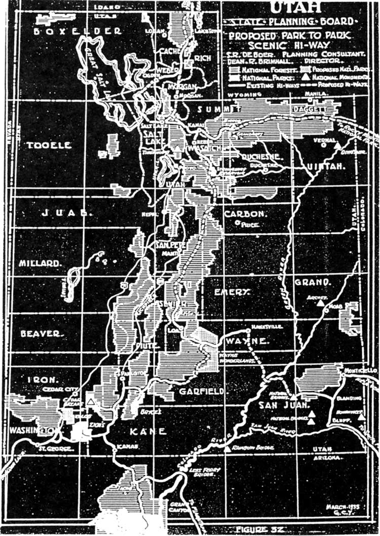
In the final report to the state board, consultant S. R. DeBoer recommended that "not less than 360 square miles should be acquired." Obviously, some members of state government were urging an enormous Wayne Wonderland national park or monument, even while the local grazing interests were trying to limit the area that the National Park Service would consider. DeBoer, Arentz, and others, however, were motivated by the limitless potential they saw for Utah as a recreational playground for tourists from around the country. To help sell Utah, they proposed a number of impressive projects. For example, they proposed building a series of scenic highways from the Grand Canyon to Salt Lake, and thence north to Yellowstone or east to the Rocky Mountains. From these main arteries, a secondary highway would be built from Zion and Bryce Canyon through Wayne Wonderland to Natural Bridges and beyond. This was an extension of Stephen Mather's park-to-park highway proposals back in the 1920s.
An additional, more ambitious scheme called for dredging the Green River through Stillwater Canyon to the junction of the Colorado to enable tour boats to navigate the rivers to a planned hotel at the confluence. This project was soon dropped from official consideration, but the link between a large Wayne Wonderland and the scenic highway that would bring tourism and business to southern Utah was endorsed in every year's recreational plans throughout the 1930s. [67]
When Arentz was in Wayne County, he noticed that Emergency Conservation Work crews were busy improving the road over Boulder Mountain from Boulder to Grover. He wondered if such crews could be put to use improving Wayne Wonderland as well. Herbert Maier, National Park Service/State Parks coordinator for the ECW, responded that the application was interesting, but that it arrived too late for consideration for at least another year. [68]
At the beginning of 1935, National Park Service Director Arno Cammerer officially petitioned Secretary Ickes, asking that lands being considered for monument inclusion be withdrawn from Taylor Act grazing districts. Included in this request were Wayne Wonderland, the Kolob Canyons adjacent to Zion National Park, a Yampa Canyon National Monument near Dinosaur National Monument, and an enormous area "in southeastern Utah and northern Arizona, on both sides of the Colorado River, from its junction with the Green River to Grand Canyon National Park." This huge area would be proposed a year later as Escalante National Monument. As for Wayne Wonderland, Cammerer described "spectacular scenery of red and white sandstone formation, narrow gorges, several natural bridges, some cliff dwellings of prehistoric Indian tribes, petrified trees, and other features of interest." Its attractions were at that time viewed by few people other than local residents, he observed, noting, "If a project for a highway across the Colorado River ...should materialize...[the area's] accessibility would be greatly increased." [69]
From this description, it is clear that the National Park Service was also hoping for the construction of that southern Utah highway to link its national parks from Mesa Verde to Zion.
In 1935, Conrad Wirth, National Park Service assistant director for land planning, suggested expanding the boundaries to include the Moccasin Cave and Fish Creek Cove archeological sites west of the proposed monument. Because of a report from the Peabody Museum at Harvard (which sponsored the first archeological surveys by Noel Morss of the area back in the late 1920s), Wirth asked Pectol to consider reattaching the Fremont River gorge and extending this strip all the way to include Fish Creek Cove, near Teasdale. Wirth makes it clear that grazing considerations, rights-of-way, and the "successful cultivations" at Fruita would need to be considered before such an addition would be made. [70]
This proposed addition of the Fremont River gorge and Fish Creek would receive a great deal of attention throughout the year. The desire to incorporate Fruita as a smooth connection between the Capitol Reef sections and the narrow strip toward Fish Creek Cove would become the most significant legacy of this latest boundary debate. In April 1935, Pectol was officially informed by Associate Director Demaray that the town of Fruita was being considered as part of the monument in order to "provide for better administrative control along the course of the Fremont River." Assurances were made that "this arrangement would not place any hardship on the owners of private land as the proclamation for establishment would be drawn up to protect existing rights." [71]
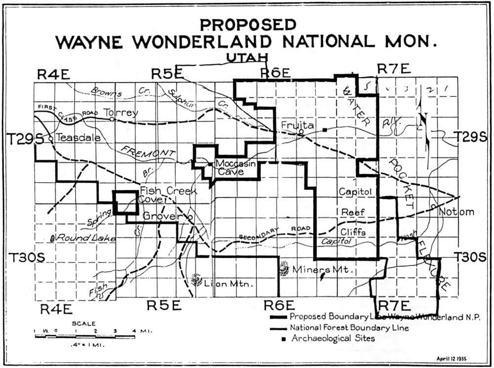
In early 1935, the revised state plan for recreation was still promoting a 360-square-mile park. The scale makes specific boundaries difficult to determine, yet it appears that the state plan called for including the entire Spring Canyon and Polk Creek drainages up to the national forest boundary in the north, and the Waterpocket Fold as far south as the Circle Cliffs. The south and west boundaries would also abut the national forest line on the flanks of Boulder Mountain (Fig. 19). Nothing more specific is detailed in this 1935 state plan. It seems likely, however, that this proposal from various Utah officials was independently made, and was not being submitted with either the help or knowledge of the National Park Service, Pectol, or the Associated Civic Clubs of Southern Utah. [72]
|
| Figure 19. 1935 boundaries, as proposed by the Utah State Planning Board. (click on image for an enlargement in a new window) |
Meanwhile, the ACCSU was concerned that the National Park Service proposal for monument as opposed to park status would adversely affect development in Wayne Wonderland. Director Cammerer reiterated that the scientific and archeological features in the area lent themselves more toward monument status. Cammerer tried to calm the boosters' fears by reminding them, "Wayne Wonderland is no less important than other areas which have been classified as national parks." [73] Zion Superintendent Preston Patraw also tried to assure the ACCSU and Rep. Pectol that monument status was the best at the time. While acknowledging that monuments tend to receive less money and staff than national parks, he pointed out that funding is usually allocated on the basis of need. In other words, if Wayne Wonderland were made a national monument, its future allotment of funds would be governed more by its needs for protection and for service to visitors than by the fact that it was a monument rather than a park. Patraw pointed out that a Wayne Wonderland National Monument could be created through presidential proclamation much more quickly than a park could be established through the slow, congressional process. This would "hasten the time" when the area could receive improvements, as from the CCC. [74]
The CCC possibility must have been attractive to local businessmen because of the positive economic impacts it promised depressed rural Utah. Another argument for monument status came from Rep. Abe Murdock, who told the ACCSU that continued reports of opposition to Wayne Wonderland from area ranchers were "holding up the park status." Accordingly, the ACCSU decided to accept the national monument designation for the time being, but to continue pushing for a future upgrade to national park status. [75]
Superintendent Patraw visited Wayne County for the first time in March 1935 and was impressed not only by the scenery, but also by the recently graded dirt road into Fruita. Patraw reported to the director that the improved road would soon bring more tourists to the area. He urged that a couple of CCC camps be established within the year to begin work on "campgrounds, water and sanitation systems, trails, and so forth." [76] This visit by Patraw once again buoyed local hope for an imminent proclamation from the federal government. The Richfield Reaper reported that Patraw's visit meant that, at long last, the National Park Service finally intended to take action.
"When President Roosevelt issues the proclamation making the region a national monument," the Reaper predicted, "one of the most persistent fights ever started in southern Utah will end." According to the paper, all that was needed was a final boundary survey to pacify the grazing interest, and then the president could act. Few people, including Superintendent Patraw, realized that it would be another two years before the monument was established. [77]
In June, Patraw returned to Wayne County to conduct that final survey. Traveling by car, horseback, on foot, and by airplane, Patraw and his accompanying survey engineer, architect, and wildlife technician accomplished a great deal. They determined a new set of boundaries and the exact amount of public and alienated lands, evaluated the potential of the Fish Creek Cove addition, and conducted the first scientific examination of flora and fauna. The airplane trip (the first documented aerial inspection of the park) was significant because Patraw and his party determined that the Navajo Domes above Cottonwood and Burro Washes should be included, as should the entire eastern slope of the Waterpocket Fold (Fig. 20). This latest revision now put the southern boundary along the Wayne-Garfield county line and added several square miles to the east. Patraw talked with the Durfey family of Notom Ranch and Rudolph Cook of Floral Ranch, both along Pleasant Creek; neither objected to this expansion. The main argument for including the eastern sections was to encompass "the toe of the east slope of the Fold, for geologic reasons and to provide additional winter range considered by the Wildlife Division representative to be needed." [78]
|
| Figure 20. 1935 boundaries as proposed by Preston Patraw. The additions are imprecise, owing to aerial reconnaissance. (click on image for an enlargement in a new window) |
Patraw dismissed the potential of grazing in the proposed monument, suggesting that any extant grazing rights could be eliminated without too much of a problem. Yet, Zion National Park's superintendent was quite aware of potential conflicts with area stock growers. Apparently, Pectol tried to reassure Patraw that the ranchers would not object to these extensions because they incorporated no good grazing land. Patraw, however, was unconvinced. He reported, "[T]his assurance may not be taken as entirely accurate, but sufficiently so to indicate that whatever opposition might develop would probably be based more on the enlargement itself than on any grazing value included in the enlarged area." [79]
It seems Patraw realized that opposition was not tied directly to established grazing rights, but was generally concerned with any attempt by the federal government to restrict use of the open range. Bear in mind that at the same time Wayne Wonderland's boundaries were being drawn, the new grazing districts authorized by the Taylor Grazing Act were also being mapped out. Area ranchers sensed that their traditional, open use of the desert lands of Wayne and Garfield Counties was over. They must have been even more concerned over a national monument that seemed to be expanding, even if very slightly, with each National Park Service visit.
The private lands in Fruita were another concern for Patraw. He agreed with the National Park Service director's suggestion that Pectol work out new boundaries that would include Fruita. Yet, in Patraw's opinion, the National Park Service should actively attempt to purchase all the private lands. He argued:
Fruita is the logical place for locating the center of future monument developments, and under continued private ownership uncontrolled and competitive development of tourist accommodations is bound to follow progressively with [the] increase of tourist visitation. Owners will want to put up tourist camps, serve meals, sell souvenirs, and run dude ranches, or lease out parcels of their lands to others for the purpose. [80]
Patraw warned that the price, rather than the availability, of the land would be the main obstacle to purchasing the private holdings. There were an estimated 100 acres in fruit and alfalfa cultivation. One owner hinted that $1,000 an acre would buy him out, whereas the largest landowner, Cass Mulford, wanted $5,000 per acre. Obviously, at least some of the residents of Fruita were willing to sell their orchard farms, so long as their asking price was met.
The report concluded that administration and protection of the proposed monument would not present many problems--except for the private lands at Fruita. Trails from the canyon bottoms to scenic features such as Hickman Bridge could be easily built, and the only road through the monument was bound to get better. As a matter of fact, plans were already being made to divert Utah Highway 24 from Capitol Gorge to the Fremont River corridor. As for the Fish Creek Cove area, Patraw reported that the archeological ruins had already been extensively dug up, and that recent inscriptions had spoiled the rock art. Because of this vandalism, plus the fact that much of the area was privately owned, he advised eliminating this area and the Fremont River gorge (again) from consideration, unless a competent archeologist disagreed. [81]
Perhaps the most significant suggestion in Patraw's report was the change in name from Wayne Wonderland to Capitol Reef. According to Patraw, neither "Wayne" nor "Wonderland" were "sufficiently distinctive" to describe the proposed area. Since "Waterpocket Fold National Monument" was too long, Patraw suggested "Capitol Reef," the local name for the prominent domes and cliffs that would be at the center of the new monument. [82]
Some local residents and historians have assumed that the new name, "Capitol Reef," was thrust on the monument without the consent of the Wayne County boosters. [83] First, the name "Capitol Reef" was actually not very new at all. It was being used interchangeably with "Wayne Wonderland" in The Richfield Reaper as early as the 1925 promotions for a state park. [84] Second, the assumption that the name Capitol Reef was selected without local approval is also untrue. Roger Toll wrote Pectol after receiving Patraw's report, and asked his opinion. Toll liked the name change because "it is undesirable to apply the name of a county to the area since that suggests a much more local type of interest." [85] Contrary to some accounts, super-booster Ephraim Pectol seems to have agreed readily to the name change. A week later, Pectol wrote Toll:
Capitol Reef National Monument has been my selection for a long time as it embraces the Capitol Reef area, but [I] was fearful the service might think this would detract somewhat since 'Wayne Wonderland' had been placed on many of the maps.... 'Capitol Reef National Monument' suits me. [86]
A year later, Pectol did confide with Associate Director Demaray that he would have preferred Wayne Wonderland, but said that he was more than willing to stick with the name Capitol Reef. [87]
Now that the name and monument status were agreed upon, all that remained was to set final boundaries that would meet the approval of all interested parties. Pectol made one last attempt at larger boundaries when he proposed that the entire area between Fruita and the national forest lines be added, including the town of Torrey. Pectol was counseled by both Toll and Patraw that this was not a good idea, due to likely conflicts with private landowners, the forest service, and area ranchers. Finally, at the end of August, Pectol reluctantly withdrew this proposal. Pectol concluded that, since additional delays were undesirable, "the area now embraced [should] be accepted as outlined." [88]
Unfortunately, the definition of final boundaries was not easy. Consideration of private holdings, real and/or potential grazing rights, and the newly proposed, enormous Escalante National Monument would delay Capitol Reef's establishment for another two years.
The Escalante National Monument
Debate
A key reason for Capitol Reef's delay was the displute over the proposed Escalante National Monument. As mentioned earlier, resistance over Cedar Breaks National Monument and to Zion's expansion into the Kolob Canyon area came largely from multiple-use advocates such as miners and ranchers. Faced with a deepening economic depression and the passage of the Taylor Grazing Act, stock growers were particularly wary of additional federal attempts to regulate their livelihood. The announced proposal to exclude almost the entire Colorado Plateau from grazing in order to establish a huge national monument was met with the most determined and vocal resistance to date. The initial plan was to eliminate grazing from almost 7,000 square miles from Green River, Utah, south to the Arizona border, and from Moab and Blanding west to the town of Escalante, pending investigation of the area's merits as a national monument.
The Escalante National Monument proposal delayed Capitol Reef's final reports and boundary surveys, needed before presidential proclamation could establish Capitol Reef National Monument. Shortly after Patraw's report was sent to Toll, Assistant Director for Operations Hillory Tolson suggested that the Wayne Wonderland nomination be postponed until the National Park Service could determine how much land needed to be withdrawn from the newly created grazing districts. Tolson observed that this delay was particularly irritating to Rep. Murdock, who evidently was the only member of the Utah delegation pursuing the project. [89]
In December, Toll found out just how much land was being considered. The initial desire to create a national monument outlining some of the Colorado River's larger canyons in Utah now included not only the Circle Cliffs, but the proposed Capitol Reef area as well: Capitol Reef was to be swallowed up by Escalante, as it was "more logical to combine in one administrative unit" (Fig. 21). Another option briefly considered was to reduce the size of Escalante, and stretch Capitol Reef's boundaries down the length of the Waterpocket Fold, an option eventually taken some 60 years later. [90]
|
| Figure 21. 1936 proposed Escalante National Monument boundaries. (click on image for an enlargement in a new window) |
In June 1936, National Park Service officials Patraw, Jesse Nusbaum and David Madsen met at Price with affected residents of the proposed Escalante National Monument. Although some (such as from Frank Martines, president of the Associated Civic Clubs of Southern Utah) supported the monument, most were ranchers and miners who made their living on the Colorado Plateau. Rancher after rancher spoke against the proposal. Even the state planning board representative insisted that the proposed area would have to remain open to mining and livestock use. [91] The result of this meeting was an immediate retreat by the National Park Service: the proposed Escalante National Monument was withdrawn for the time being. Further study of the Escalante area was proposed, "to determine where reductions may be made with least detriment to the project and, also, to establish the Capitol Reef area as a national monument without further delay."
The embattled Escalante monument was eventually reduced to a still-imposing strip varying between three and 50 miles in width between the confluence of the Green and Colorado rivers and the Arizona border. In an attempt to secure this land for the National Park Service, compromises would allow grazing and even permit construction of hydroelectric dams at the mouths of Glen and Dark Canyons. This proposed monument eventually evolved into Glen Canyon National Recreation Area and Canyonlands National Park. [92] Meanwhile, the focus shifted once again to creating a small Capitol Reef National Monument in isolated Wayne County.
A National Monument Is Created
Before creation of the monument could be approved, final boundaries had to be determined. While Pectol continued his campaign to include more of the Sulphur Creek and Fremont River drainages, Toll and Patraw worked on refining and down-sizing the western border. Shortly after Patraw's 1935 report, Toll recommended (with Patraw's concurrence) that the recently improved, graded state highway right-of-way from Chimney Rock to Fruita should be the boundary line. This line was proposed to avoid "complications of construction or maintenance" along Utah Highway 24. From this point on, the northern perimeter of the highway's right-of-way would become part of the western boundary until a minimal expansion in 1958 absorbed the entire road. [93]
By mid-1936, Pectol was still proposing additional boundary ideas, even during a long and serious illness that almost cost his life. By this time, however, National Park Service officials were trying to finalize the boundary; additional, unsurveyed parcels were no longer desired, especially if they included private or grazed lands. [94] The only new section added was about three miles of red cliffs and mesa-top northwest of Chimney Rock to the Fishlake National Forest boundary. This included the southern edge of Meeks Mesa, which retained a few traditional grazing privileges. [95]
Toward the end of 1936, Fish Creek Cove was eliminated and the Fremont River section scaled back. In October, National Park Service Archeologist Jesse Nusbaum visited the archeological sites in Fish Creek, determining that "it was undesirable to place this section within the proposed monument" due to the extensive diggings and vandalism there. It was also recommended that the Fremont River segment be limited to the actual gorge, placing the western line just east of Carcass Creek. [96]
By the end of 1936, all known correspondence relating to the creation of Capitol Reef National Monument ended. It was now time for the Washington office to finalize boundaries and prepare a presidential proclamation. Why this took until the end of July 1937 is unknown, but a tremendous backlog of proposed areas may have been a factor. A multitude of new parks and monuments, mostly in the Southwest, were under investigation throughout 1936 and 1937. Besides the troubles with the Escalante proposal, there were also the additions to Dinosaur National Monument and the Kolob Canyon area north of Zion National Park to be considered in Utah. Organ Pipe and Kofa Mountains in Arizona, as well as a couple of sites in New Mexico, were also under investigation. Adding to the turmoil of these investigations was the unexpected death of Roger Toll in a automobile accident in the spring of 1936. The Capitol Reef proposal would have to wait its turn. [97]
The Department of the Interior finally submitted a form of proclamation to President Roosevelt at the end of July. The scientifically and beautifully unique geology of the Waterpocket Fold was the dominant reason expressed to the president as to why Capitol Reef should be set aside as a national monument. The report to Roosevelt said:
[The Waterpocket Fold is] a vast monocline, which has played a dominant part in the forming of the physiography of the plateau region, [which] is brought to a dramatic climax in the vicinity of Capitol Reef, a colorful buttressed escarpment of sandstone which extends throughout the length of the proposed monument...Here also is exhibited the work of erosion in the modeling of buttressed cliff and talus slope which are a predominating note in the physiography of the Colorado River watershed. [98]
Mentioned as a contributing factor were the "archeological remains of the Basketmakers."
Grazing interests and the concerns of private landowners in Fruita were also addressed. To insure proper protection for the new monument, all previous land withdrawals were revoked by the Secretary of Interior. This included the Federal Power Reserve sites, the 120 acres withdrawn by the State of Utah in 1930, and 3,480 acres which had been reserved for stock driveways. The secretary also signed an order excluding all monument lands from the grazing districts, thereby prohibiting grazing on any portion of the new monument. In return, the proclamation would include special regulations to accommodate the livestock drives through the area, specifying:
Nothing herein shall prevent the movement of livestock across the lands included in this monument under such regulations as may be prescribed by the Secretary of the Interior and upon driveways to be specially designated by said Secretary. [99]
As for the security of private lands, the proclamation specifically protected all valid, existing rights. The approximately 1,880 acres in private ownership, mostly in Fruita, were therefore not immediately affected by the establishment of the monument. [100]
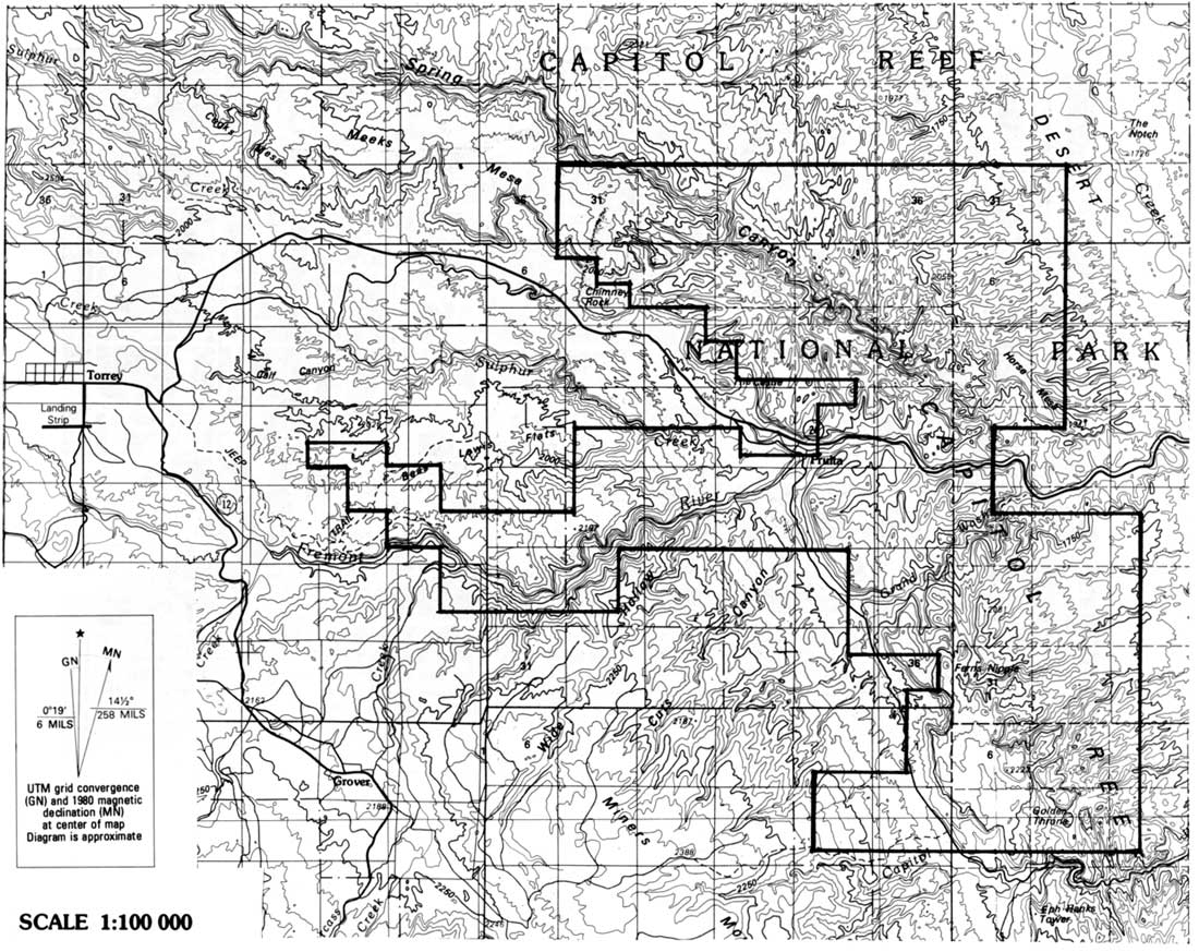
The final boundary was very similar to that agreed upon by Patraw, Toll, and Pectol a year earlier. Capitol Reef National Monument would be 37,060 acres, approximately 58 square miles. Its dimensions were about 18 miles from the northwest tip to the southeast corner. It was roughly two to five miles wide. The only major change was elimination of the Fremont River gorge west of Fruita. Also added were small sections of land selected so that the road between Fruita and Capitol Gorge would lie almost entirely within the monument boundaries and Sections 5 and 29, Township 29, Range 7, so that the eastern boundary was a straighter line. Fruita remained within the monument, as did the southern half of Meeks Mesa. Capitol Reef, the heart of the Waterpocket Fold down to the Wayne-Garfield County line, was the backbone of the newest unit of the National Park Service (Fig. 22).
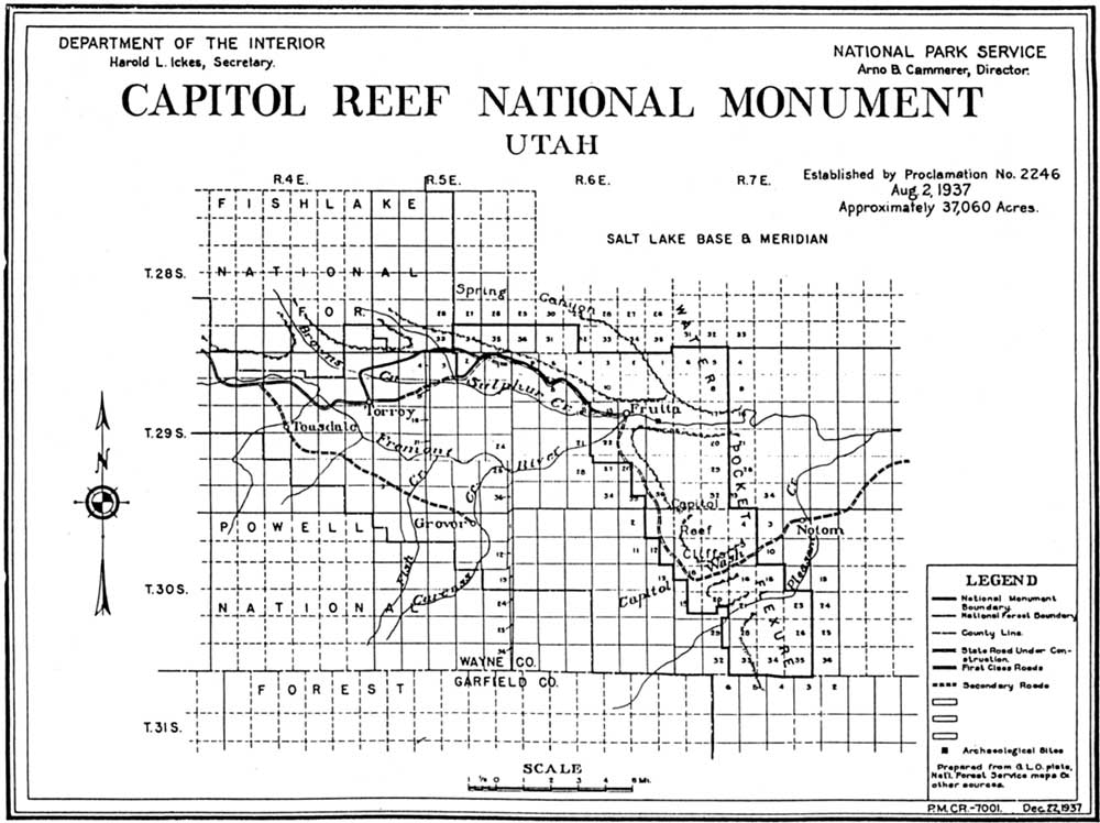
|
| Figure 22. 1937 Final boundaries, Capitol Reef National Monument. (click on image for an enlargement in a new window) |
On August 2, 1937, Capitol Reef National Monument was officially established. At the dedication ceremony on September 25, an optimistic future for Capitol Reef was predicted by every dignitary and supporter. Gathered at Echo Rock in Grand Wash were, among others, Gov. Blood, Rep. Murdock, Frank Martines and Ray Carr of the ACCSU, National Park Service Regional Director Kittredge, and Superintendent Patraw. The master of ceremonies was, of course, Ephraim Pectol, who after more than a decade of persistent work had finally seen his dream come true. [101]
Predictably, the elected officials spoke of the opportunities for economic stimulus that the new monument would mean for Wayne County and all of Utah. They voiced the need for rapid development of roads and tourist facilities so that visitors from around the country could come and enjoy the scenic splendors around them. The link between Capitol Reef's establishment and improved roads was again a prominent theme, just as it had been at the 1925 celebration. Gov. Blood declared:
It needs no prophet's vision to foresee the time when this monument will be one of a chain of similarly valuable scenic attractions, and when a highway system will link them with the natural bridges and the Mesa Verde National Park to the East; with the Bryce Canyon, Zion and Grand Canyon National Parks to the south, and by way of Fish Lake and the sky line road with the attractions of the Wasatch Mountains extending to the north. [102]
Blood also spoke of the need to preserve the archeological artifacts that were being stolen and vandalized across the state. Perhaps most interesting, however, is Blood's reference to the need for federal help in preserving, as well as developing, the monument's resources. He predicted:
Proper control, or at least better control than there has been in the past, will result from the establishment of this Capitol Reef National Monument. Uncle Sam will help us, and indeed, may direct us. At least we shall have the advantage of the leadership and advice of the men skilled in the handling of such problems, whom the park service may send here or choose to train from among our own people. [103]
Thus, it seemed that at least the governor was willing to listen to the National Park Service plans to protect this fledgling national monument. Few of the local residents, however, realized just how long it would take to develop and implement those plans.
Regional Director Kittredge, the highest ranking federal government official in attendance, spoke of the need to preserve the "primitive naturalness" of the national parks, alluding to damage from overgrazing as he declared:
There are great public domains which must not be devastated by erosion else our children's children must move out or starve as has happened to great areas in central China – once fertile, now barren wastes – as has begun to happen to a few of our own region....Our Secretary [Ickes] is determined...to protect the public domain against erosion. [104]
Kittredge tempered these remarks by speaking of the need and desire to develop roads and trails in the monument, but before such development could be made, he stressed, there must be a comprehensive study of the area. "We cannot afford to go into this new region," he declared, "before a scientific study has been made of objectives which must be reached and those which must not be disturbed. ["105]
For Pectol and the other early promoters of Wayne Wonderland, the need for planning was probably forgotten in the jubilant celebration of their achievement. Pectol and the others surely believed now that the monument was established, the roads would be built and the tourists would come. Yet, history of the monument's creation might have foreshadowed the delays and struggles struggles to come.
Summary And Conclusions
From the earliest attempts at promotion through the abortive state park movement, the local boosters acted independently, on their own. No one had heard of, much less visited, their Wayne Wonderland due its isolation. Once the National Park Service began to investigate the area, there were continual delays due to boundary questions, far-reaching distractions such as the Escalante National Monument proposal, and the opposition from local ranchers.
The isolation of Capitol Reef would continue until a paved road was finally built through the Fremont River canyon in the early 1960s. The physical barriers of the Waterpocket Fold and the Colorado Plateau would prevent a fast, through highway from being constructed until then. Because the physical barriers prevented access, National Park Service development was also slow in arriving. When development plans and expansion were finally ready to breach these barriers, the old opposition from ranchers and other multiple-use proponents once again emerged. The crossroads at which Capitol Reef found itself in the late 1960s was first encountered in the struggles to create the national monument in the 1930s. The cast had changed, but the issues and problems remained the same.
For an account of the growth and evolution of National Park Service management of Capitol Reef from 1937 turn to Chapter 5; or continue on to read of the monument's expansion in the 1950s and late 1960s, and its establishment as a national park in 1971.
Footnotes
1 Robert Shankland, Steve Mather of the National Parks, 2nd ed. (New York: Alfred Knopf Press, Inc., 1954) 138-139.
2 Alfred Runte, National Parks: the American Experience (Lincoln: University of Nebraska Press, 1979, revised 2nd ed., 1987) 82-105, is a thorough treatment of the beginning days of the National Park Service and its attempts to attract wealthy tourists.
4 Anne Snow, Rainbow Views: A History of Wayne County, 4th ed. (Springville, Utah: Art City Publishing, 1985) 79, gives a good account of early road-building in Wayne County. Also see Dwight King, "The Blue Dugway," Utah Historical Quarterly 49 (Winter 1981): 66-67, for a flavorful description of travel on the Blue Dugway; and Angus M. Woodbury, A History of Southern Utah and Its National Parks (published by author, 1950) 205-209, for a comparative account of road building and development around Zion and Bryce Canyons.
5 Charles Kelly, "Biographical Sketch of Ephraim Pectol," Charles Kelly Unpublished Writings, Capitol Reef National Park Unprocessed Archives, 2; Snow, Rainbow Views, 148-149.
6 Charles Kelly, "History of Capitol Reef National Monument," Box 3, Folder 12, Capitol Reef National Park Archives, 12.
7 House Bill 56, Utah State Legislature, 16th Session, Utah State Archives.
8 See Patrick W. O'Bannon "Capitol Reef National Park: A Historic Resource Study," June 1992, 60, prepared for National Park Service, on file, Intermountain Regional Office, Denver as an example.
10 Kelly, "History of Capitol Reef National Monument," 12.
11 Richfield Reaper, 9 July 1925.
18 1927 House Journal, Utah State Legislature, 17th Session, Utah State Historical Society Archives, 36-37.
19 Ben Thompson to Moskey, 19 February 1937, Box 1, Folder 5, Capitol Reef National Park Archives; 97, General Land Office Township and Range Plats, Book 57, Records of the Bureau of Land Management, RG 49, National Archives - Suitland, Maryland. State archivists searched through official state and governor's records and correspondence, but found nothing in reference to this land withdrawal.
20 Kelly, "Biographical Sketch of Joseph S. Hickman," 12 February 1952, Charles Kelly Unpublished Writings, Capitol Reef National Park Unprocessed Archives, 3.
21 H.B. 127, 17th Utah Legislature, 1927.
22 "Preliminary Staff Reports, Utah State Planning Board," Series 1164, State Planning Board, Independent Commissions Reports, 1934-1941, Utah State Historical Society Archives, Salt Lake City, 10.
23 Ibid.; Dr. Everett Cooley, former director of the Utah State Historical Society and former State Park Commission member, telephone conversation with author, 30 November 1993.
24 Kelly, "Biographical Sketch of Ephraim P. Pectol"; Snow, Rainbow, 148, 164.
25 Kelly, "Biographical Sketch," 2; Snow, Rainbow, 149.
26 Kelly, "Biographical Sketch," 2; Snow, Rainbow, 149.
27 Allen to Horace Albright, 15 July 1931, File NPS-100, Accession #79-60A-354, Cont. #63179, Box 1, Records of the National Park Service, Record Group 79 (RG 79), National Archives and Record Center - Rocky Mountain Region, Denver (hereafter referred to as NA-Denver).
29 Arno Cammerer to Horace Albright, 8 August 1930, Toll Papers, Box 1, Folder 2, Western History Collection, Denver Public Library.
31 Ibid. No bills, resolutions or hearings have been found in the Congressional Record documenting any attempt by the Utah congressional delegation to support the creation of Wayne Wonderland park.
33 Allen to Toll, 15 July 1931, File NPS-100, 79-60A-354, Container #63179, Box 1, RG 79, NA-Denver.
34 Robert Shankland, Steve Mather of the National Parks, 247-248.
35 Allen to Albright, 30 July 1931, File 207, Entry 7, Box 2063, Central Classified Files 1907-49, RG 79, National Archives, Washington, D.C. (hereafter referred to as NA).
37 Cameron to Allen, 4 October 1931, File NPS-100, Box 1, 79-60A-354, RG 79, NA-Denver. No record of the description from the ACCSU has been found.
38 Cameron to Allen, 30 November 1931, Ibid.
39 Toll Papers, Box 1, Folder 2, Western History Collection, Denver Public Library.
40 Toll to NPS Director, 8 November 1932, Box 1, Folder 1, Capitol Reef National Park Archives.
42 Barry Mackintosh, The National Parks: Shaping the System (Washington, D.C.: U.S. Department of the Interior, 1991) 10-59, passim; John Ise, Our National Park Policy: A Critical History (Baltimore: Johns Hopkins Press, 1961) 339-354.
43 Mackintosh, 22-59; Ise, 411.
44. Elmo R. Richardson, "The Escalante National Monument Controversy of 1935-1940," Utah Historical Quarterly 33 (Spring 1965): 110-111.
45 Hal Rothman, "Shaping the Nature of a Controversy: The Park Service, the Forest Service, and the Cedar Breaks Proposal," Utah Historical Quarterly 55 (Summer 1987): 219-223.
49 House Concurrent Motion No. 4, Laws of the State of Utah passed by the 20th Legislature, Utah State Historical Society Archives, 161-162; Richfield Reaper, 2 March 1933.
50 H.C.M. No. 4. This is the first time a national monument is mentioned as acceptable in any correspondence from Utah. In all previous letters, a national park was the only designation sought.
51 Richfield Reaper, 2 March 1933.
53 Toll Investigation, 1934 Report, File NPS 000, 60A-354, Container 63179, Box 1, RG 79, NA-Denver.
54 Albright to Pectol, 18 March 1933, Box 11, Entry 20, Records of Roger W. Toll, RG 79, NA.
55 "1934 Toll Report on Proposed Wayne Wonderland," Box 11, Entry 20, Box 11, RG 79, NA.
58 Ibid. The accompanying map to the 1934 Toll report (#9) found in the Capitol Reef National Park Archives gives slightly larger boundaries than those listed in the actual report. This enlargement could be an incorporation of Toll's final suggestions.
59 Parks Commission Files, Correspondence of Gov. Blood 1933-34, Series 021003, Utah State Historical Society Archives.
60 Ibid.; Harold Ickes to William King, 28 February 1934, File 12-0, Part IV, Box 1972, Records of the Secretary of the Interior, RG 48, NA.
61 Petition included in 1934 Toll report.
62 Toll to Pectol, 13 April 1934, and Pectol to Toll, 1 May 1934, Box 11, Entry 20, RG 79, NA.
63 Clarke, "To Whom It May Concern," 4 May 1934, Ibid.
64 Ibid. If the monument were to be created with such boundaries, it would have looked somewhat like a rectangle eight miles by eight miles, with a northwest arm extending out to Chimney Rock, a shorter eastern extension along the Fremont River, and a jog around the private lands of Fruita. The size would be roughly 32 square miles.
65 Toll to Pectol, 8 May 1934, Ibid.
66 "Recreational Report of Utah, Preliminary Staff Reports, Utah State Planning Board," Series 1154, State Planning Board, Independent Commissions, Reports 1934-1941, Utah State Historical Society Archives, 5.
67 "Recreation Report of Utah," 5,10-12, Ibid.
68 Maier to Arentz, 22 July 1934, Correspondence, Series 1161, Utah State Historical Society Archives. (The actual application has not been located.)
69 Cammerer to Ickes, 11 January 1935, File 12-0, Part IV, Box 1972, RG 48, NA.
70 Wirth to Pectol, 25 January 1935, File 100, 79-60A-354, Box 1, Container #63179, RG 79, NA-Denver.
71 Demaray to Pectol, 26 April 1935, box 11, Entry 20, RG 79, NA.
72 "A State Plan for Utah," Progress Report, 15 April 1935, Series 1164, State Planning Board, Independent Commission, Reports 1934-41, Utah State Historical Society Archives.
73 Cammerer to Carr, 2 February 1935, File NPS-100, 79-60A-354, Box 1, RG 79, NA-Denver.
74 Patraw to Carr, 11 February 1935, Ibid.
75 Richfield Reaper, 14 February 1935.
76 Patraw to NPS Director, 28 March 1933, File NPS-100, 79-60A-354, Box 1, RG 79, NA-Denver.
77 Richfield Reaper, 28 March 1935.
78 P. P. Patraw, "Report on Proposed Wayne Wonderland National Monument," August 1935, Box 1, Folder 2, Capitol Reef National Park Archives. This report also contains the first known naturalist's report regarding the proposed monument since the Powell survey in the 1870s.
83 Johnathan Scott Thow, "Capitol Reef: The Forgotten National Park," (Utah State University Master's Thesis, 1986) 47, uses the local paper, the Richfield Reaper, as his source regarding the unpopularity of the name.
84 See headlines and stories in the Richfield Reaper, 23 and 30 July 1925, for examples.
85 Toll to Pectol, 23 August 1935, Box 11, Entry 20, Box 11, RG 79, NA.
86 Pectol to Toll, 31 August 1935, Ibid.
87 Pectol to Demaray, 1 April 1936, File NPS-100, 79-60A-354, Box 1, RG 79, NA-Denver.
89 Tolson to Toll, 17 August 1935, Box 11, Entry 20, RG 79, NA.
90 Toll to Patraw, 16 December 1935; Tillotson to Director, 18 December 1935, File NPS-100, 79-60A-354, Box 1, RG 79, NA-Denver. "Notes on Proposed Escalante National Monument," April 1936, Series 1171, Utah Economic Resources 1930-49, Utah State Historical Society Archives, contains an NPS-generated map that shows the Capitol Reef boundaries within the proposed Escalante National Monument.
91 Elmo R. Richardson, "The Escalante National Monument Controversy of 1935-1940," 114-117.
93 Toll to Patraw, 19 August 1935 and Patraw to Toll 22 August 1935, Box 11, Entry 20, RG 79, NA. Pectol's desire to include the Sulphur Creek and Fremont drainages to the west may be in part due to the extensive archeological exploration he had done in those areas for many years.
94 Pectol to Patraw, 31 January 1936, File NPS-100, 79-60A-354, Box 1, RG 79, NA-Denver, is an example of many of the letters from Pectol at this time.
95 Cammerer to Pectol, January 1936, Ibid.
96 Patraw to Director, 27 October 1936, Ibid.
97 Ise, Our National Park Policy, 422-423.
98 West (for Ickes) to Roosevelt, 26 July 1937, OF 928, NPS 1937-38, Box 1, Franklin Delano Roosevelt Library, Hyde Park, New York.
99 Presidential Proclamation, "Establishment of Capitol Reef National Monument," Proclamation 2246, Federal Register 2, No. 151, 2 August 1937: 136. The impact of grazing on the monument is described in Volume II, Chapter 12.
100 Ibid.; West to Roosevelt, 26 July 1937.
101 Richfield Reaper, 30 September 1937.
102 Henry H. Blood Dedication Speech, (typed copy) 5, File CR 101-01, 79-60A-354, Box 1, RG 79, NA-Denver.
104 Frank Kittredge Dedication Speech, Ibid., 1.
| <<< Previous | <<< Contents >>> | Next >>> |
care/adhi/chap8.htm
Last Updated: 10-Dec-2002