|
City of Rocks
Historic Resources Study |

|
HISTORICAL DEVELOPMENT OF THE CITY OF ROCKS REGION
Introduction
History tells of 'Granite City' where the immigrant wagons rolled, indian massacres, rattling of stage coaches and of hidden gold. I wish to tell of the simple life and dreams of these settlers who came in around the year of 1910. Water was usually dug for by a shovel and it wasn't far from the surface; and the sage brush grew high and a horseman could ride through without being seen. [11]
Distinct historic themes pertinent to the City of Rocks National Reserve include American Indian habitation, the fur trade, westward migration, the development of national and regional transportation networks, agricultural development, and recreation and tourism. Stories of conflict between Indians and newcomers, stagecoach bandits, and range wars represented fleeting moments in the history of the region. However, because they personify the Wild West, these events captured the imagination of local residents and of visitors, and stories thereof have been repeated and embellished accordingly. Overland migration was similarly fleeting, yet ultimately led to the settlement of the West, to homestead legislation, and to the growth of agricultural communities — the region's most consistent and long term land use in the post-settlement era.
The local agricultural industry followed a progression witnessed throughout the semi-arid West. The early open-range cattle industry was devastated by the winter of 1889 and disrupted by the arrival of "wool growers" and farmers. Early (ca. 1880-1900) homesteaders laid claim to irrigable land in the valley bottoms; small-scale irrigated farming was supplemented with cattle or sheep ranching. Stock grazed during the summer months on public land and were pastured (and fed) throughout the winter on the home ranch. Later settlers were relegated to dryland and grazing tracts, patented under the terms of the Enlarged Homestead, Forest Homestead, or Stockraising Homestead acts. The regional drought beginning ca. 1917 and the depression of the 1920s and 1930s resulted in the whole-scale exodus of this later community. By the 1930s, recreational use of the "beautiful" but unwatered and unproductive land was seen as the logical economic alternative to farming.
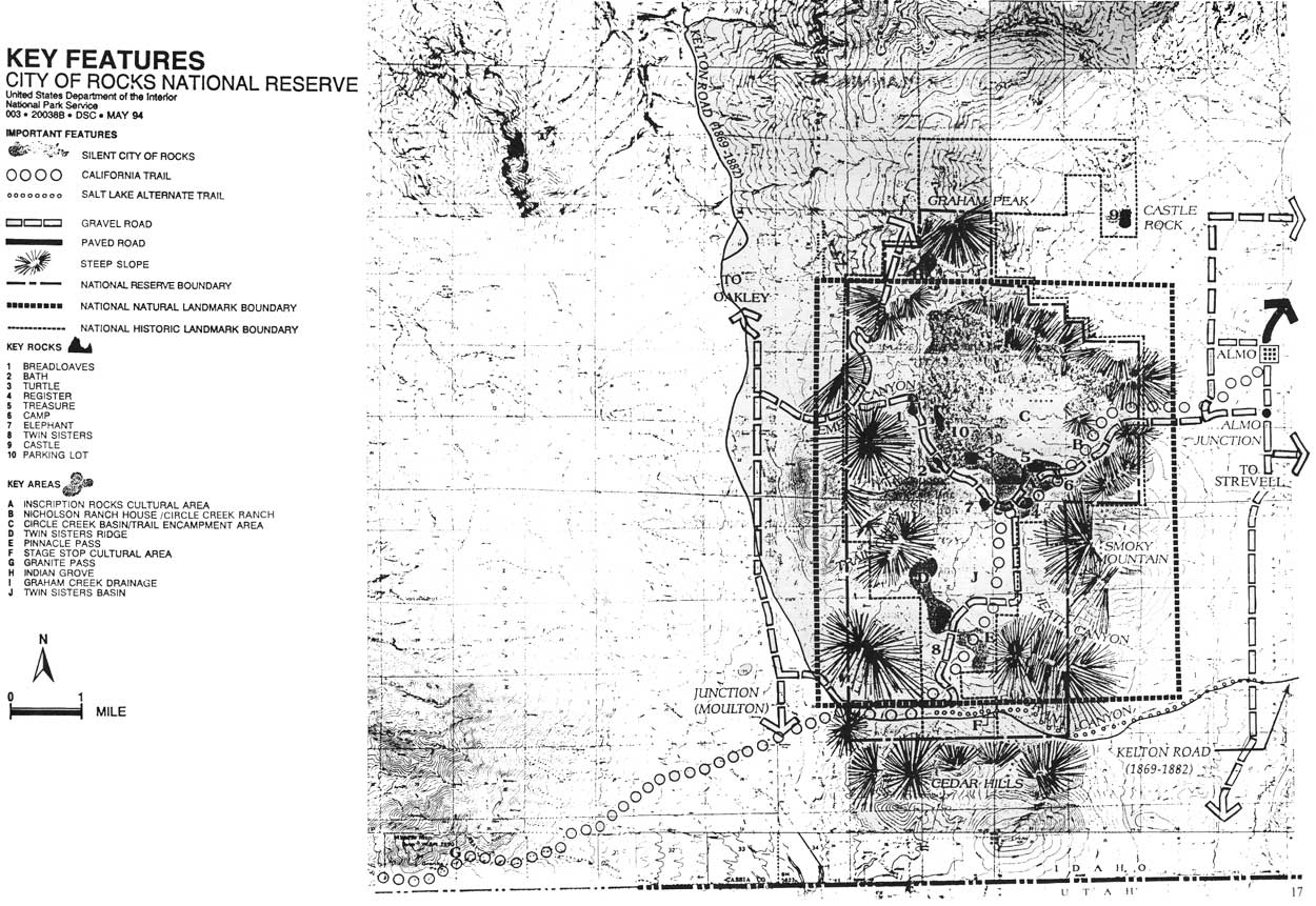
Three threads link all phases of area development: Water (or the lack thereof) brought the fur traders and the emigrants, and determined the physical characteristics and the success or failure of area farms. Transportation routes (or the lack thereof) have had a causative and resultant impact on the history of the region: the City of Rocks was at center stage of a phenomenal national emigration. Yet the transcontinental railroad and the interstate highway system — neither of which is dependent upon the presence of water, grass, or gentle grades — have passed the region by. The unique natural features of the region elicited extensive comment from westward emigrants. For those who settled and stayed, the City of Rocks has served as a community picnic ground, a point of geographic reference, and a cultural compass bearing on the importance of their community in the history of the nation and of the West (Figure 4).
|
| Figure 4. Key Features, City of Rocks National Reserve (map prepared by USDI, NPS, 1994). (click on image for an enlargement in a new window) |
The City of Rocks National Reserve occupies an area at the junction of two physiographic regions, the Great Basin and the Columbia Plateau, at the northern margin of what anthropologists call the Great Basin "culture area." The concept of culture area, as used by anthropologists for some time, is generally defined as a geographical area within which native inhabitants share similar cultural traits. Strengthening the concept of cultural relatedness within the Great Basin culture area is the fact that all but one of the extant native groups living within it speak "Numic" languages, a division of the Uto-Aztecan language family. [13]
Of course, people inhabiting the periphery of "culture areas" often display a blend of traits from adjacent areas. The Shoshone and Bannock people who occupied the upper Snake River Valley at the time of Euroamerican contact displayed a blend of cultural traits typically associated with Plains, Great Basin and Plateau cultures. "Just as the environment and resources of southern Idaho were varied and transitional to other physiographic areas, so also was the culture of the Shoshone and Bannock diverse." [14]
In September of 1776, Francisco Atanasio Dominquez and Silvestre Velez Escalante explored the region extending from Santa Fe to Utah Lake (near what is now Provo). Here they camped with the "Comanche" (Shoshone). [15] In 1805, the Lewis and Clark expedition camped near Lemhi Pass with another Shoshone band. Lewis made extensive notes regarding the material culture and vocabulary of the Shoshone people that they encountered. Lewis' lack of comment on the presence of Bannock people has led to the assumption that the residential integration of Shoshone and Bannock people occurred during the later part of the 1800s.
The relationship of the Northern Shoshone and Bannock, observed by ethnographers during the first part of the 20th century, is described as follows:
The Fort Hall, or upper Snake River, Shoshone and Bannock formed into large composite bands of shifting composition and leadership. The Shoshone speakers were always the majority, but the chieftaincy was sometimes held by a Bannock. Most of the Fort Hall people formed into a single group each fall to hunt buffalo east of Bozeman, Montana, and returned to the Snake River bottomlands near Fort Hall for the winter. . . The large bands split into smaller units for spring salmon fishing below Shoshone Falls, and summer was spent digging camas roots in Camas Prairie and other favored places. Deer and elk were hunted in the mountains of southeastern Idaho and northern Utah. [16]
Because of its excellent grazing resources, pinion pine nuts, rock chucks and game animals, and vegetable roots, the upper Raft River and the City of Rocks served as a "Shoshoni seasonal village center" and summer range for the Shoshone's extensive horse herds. [17] Almo residents reported that as late as the 1970s,
The Indians [from the Fort Hall Reservation] used to come every fall gathering pine nuts. They would gather the cones all day, then dig huge pits, fill them with wood and set it on fire. Then when the coals were right, they put the sticky cones in and covered them with dirt. By morning the cones would be popped open. The squaws picked the nuts out of the cones. They would sell them for .25 a pint. . . . every year, 'til the last few years, they come and traded back and forth with people for hides and on the years that the pine nuts were good.... they come by car. Then they first come, they come in a buggy and team, wagon and team. And camp here, they'd have a camp right here, right above here for weeks at a time. . . They'd come here and buy deer hides... They trades us buckskin gloves for deer hides. See and then they make the gloves out of the deer hides. [18]
Years after their consolidation on the government reserve at Fort Hall, the Bannock-Shoshone would return for "ceremonial dances. Their camp grounds were near the Twin Sisters as there was a spring of cold running water close by." [19] Non-Indian settlers also report an "Indian legend" centered at the City of Rocks, namely that "a bath in [Bathtub Rock] before sunrise will restore youth to the aged." [20] Evidence of the city's traditional significance thus continued long after ranching enterprises had transformed the area. [21]
Fur Trade and Exploration
I got safe home from the Snake Cuntre... and when that Cuntre will see me again the Beaver will have Gould skin. [22]
The Raft River Valley formed an important transportation link between the heavily trapped Snake and Bear rivers. Between 1820 and 1830, the Hudson's Bay Company (HBC) also heavily trapped the Raft River, as part of their general policy to decimate beaver populations in the area of joint British/American occupation established in 1818. Despite this proximity, City of Rocks was not the focus of the trappers' attention and is neither described nor mentioned in passing in the trappers accounts.
In 1811 an expedition of the Pacific Fur Company, led by Wilson Price Hunt and Donald Mackenzie, traveled down the Snake River, past its confluence with the Raft River, enroute to their new Pacific coast trading post at Astoria. Although Mackenzie was convinced that the Snake country's beaver population was considerable, the difficulty of that 1811 journey discouraged further exploration of the Snake River and its tributaries until 1818. [23]
In that year, Mackenzie, a new partner in the nascent North West Company, led the first "Snake Country Brigade" into an area extending from Fort Nez Perce south as far as the Green River and east as far as the Bear River. By 1820, Mackenzie had established a system of mobile trapping and summer rendezvous that incorporated the Upper Raft River region, near the City of Rocks. Subsequent incursions into this heretofore unexplored region were made by the Hudson Bay Company's Finian McDonald and Micel Bourdon in 1823, whose trapping grounds included the Upper Raft River and tributary creeks and by the HBC's Alexander Ross, whose brigade camped near the City of Rocks in 1824. (Ross did not proceed beyond this camp, noting a negative cost-benefit ratio to further trapping in the rugged country. Despite his proximity to the City of Rocks, and his keen interest in geography, Ross failed to mention the city in his diary, suggesting that he had neither seen nor heard of the geographic oddity.) [24]
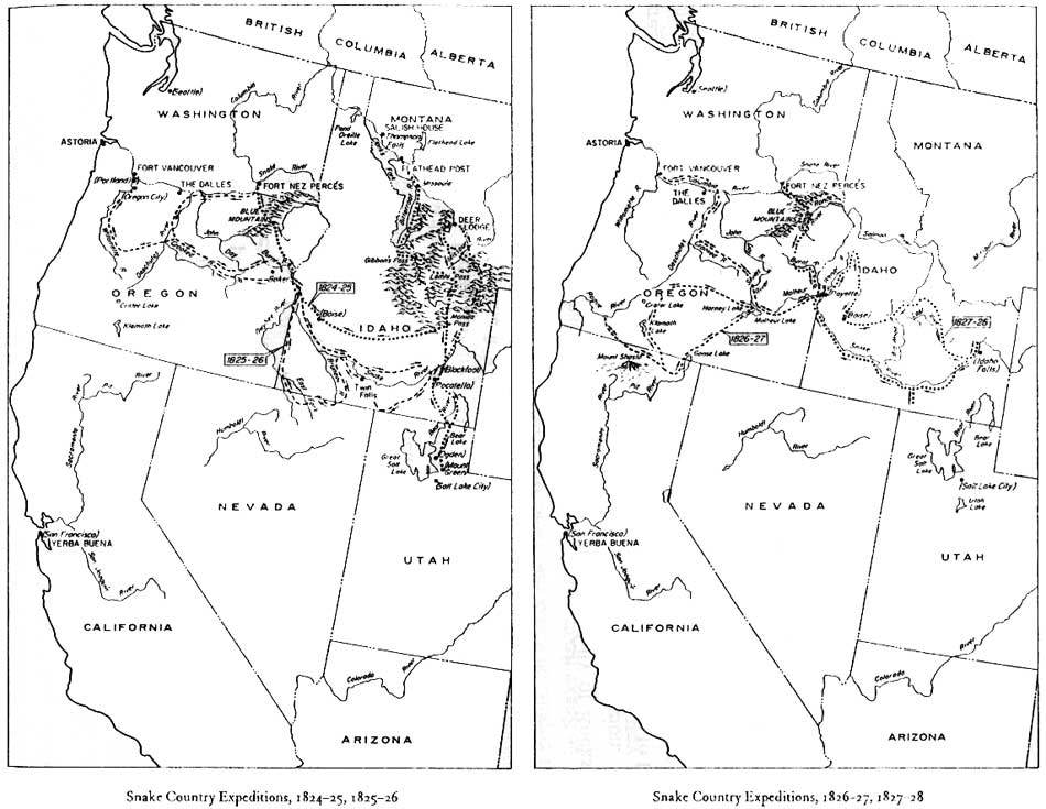
Peter Skene Ogden assumed control of Ross' Snake brigade in 1824, at a time when competition from American trappers lent incentive to further exploration of the Raft River's tributaries. (His brigade of 1825 consisted of "fifty-eight men who were equipped with 61 guns, 268 horses, and 352 traps as well as a number of women and children, families of some of the freemen who were always part of such expeditions.") In 1826, Ogden's party discovered Granite Pass; their westward journey to the pass would have placed them very near the City of Rocks. Ogden's successor John Work also explored the Goose Creek country between Junction Valley and Granite Pass yet also did not pass through the City, or failed to describe it. By 1832, Work concluded that the region immediately west of the Raft River "lacked enough beaver to justify further attention (Figure 5)." [25]
|
| Figure 5. Hudson's Bay Company Snake Country Expeditions, 1824-1828 (Gloria Griffen Cline, Peter Skene Ogden and the Hudson's Bay Company, (Norman: University of Oklahoma Press, 1974, pp. 57, 84). (click on image for an enlargement in a new window) |
Like the emigrants that would follow them, fur traders did not travel through the region uncontested: service with the Snake River Brigade was considered "the most hazardous and disagreeable office in the Indian country." During Finian McDonald and Micel Bourdon's 1823 Snake River expedition, Bourdon and five others were killed. Upon his return, McDonald wrote "I got safe home from the Snake Cuntre... and when that Cuntre will see me again the Beaver will have Gould skin." [26]
Although the fur trade had no immediate effect upon the City of Rocks, geographical discoveries made during that era had an important and lasting effect on the region. For over thirty years, in search of beaver, glory, adventure, and a watered transportation route to the Pacific, the great men of the trapping and exploration era [27] searched for a mythical Buenaventura River draining the country west of South Pass to the Pacific Ocean. The search was daunting, hindered by the extremely complicated drainage system west of South Pass. The Green, the Big Gray, the Salt, the Sweetwater, and the Bear rivers all head near South Pass. The Green flows into the Colorado, bound for the Gulf of California. The Big Gray and Salt feed the Snake, thence the Columbia, and finally the Pacific. The Sweetwater is part of the Platte-Missouri river system, and flows into the Gulf of Mexico. The Bear River flows north northwest as far as Soda Springs, where it makes an abrupt turn south to the Great Salt Lake. The lake has no outlet. [28]
Trappers and explorers focused their search for the Buenaventura on the alkaline plains west of the Great Salt Lake, south of the City of Rocks, and across which the first overland emigrants to California would pass. They would find this "a terrible country, a sandy waste men ventured upon at the peril of their lives... Even springs were scant, and likely to be bitter with salt. There were no beaver there — no riches." [29] And there was no Buenaventura:
There was no great river, there was no broad water highway to the Pacific. The drainage from the Rocky Mountains went south and north and east but not west, except for those streams like the Weber and the Bear, which ran ineffectually into the Dead Sea, and the Humboldt, which died with an alkaline whimper in the Humboldt Sink. [30]
Ogden's Snake River Brigade of 1829 discovered the Humboldt River. Although they did not know it, and although the search for the Buenaventura would not be officially conceded until 1843, this was the "lost river": a small stream with brackish water of vile taste that sank "with an alkaline whimper." Future travelers — the hundreds of thousands of emigrants bound for California — would also curse the Humboldt, while relying absolutely on its alkaline water and sparse forage, the only water, the only grass, the only refuge, in an enormous expanse of desert. [31]
Ogden was similarly unimpressed by his 1825 discovery of Granite Pass. For Ogden, the discovery was relatively inconsequential; the Goose Creek drainage was not a significant source of beaver, and fur trappers, unlike later emigrants, were not restricted in their travels to routes wide enough for wagon passage and possessing sufficient feed and water for wagon stock.
In 1833, the American Fur Company's Captain Benjamin L. E. Bonneville retained Joseph Reddeford Walker to lead a band of trappers west from Salt Lake in search of new trapping grounds. Traveling west, Walker forged a trail across what became known as the Bonneville Flats. (Six years earlier, Jedediah Smith had almost died on this passage, as would the first overland migrants to California, eight years later.) Walker traveled north of this route on his return in 1834, descending Goose Creek to the Snake River. From this vantage point, he "rediscovered" Granite Pass. In 1842, Joseph B. Chiles traveled east across the pass, and confirmed its potential as a possible, although difficult, route to the Humboldt. Granite Pass would provide the final link in an overland route between Illinois and the Sacramento Valley: the California Trail, as it ran through the City of Rocks. [32]
Overland Migration
In 1840, Thomas Farnham and his small party traveled from Peoria, Illinois to the Oregon Territory, initiating a mass migration that would peak at over 100,000 in 1852 but that would not end until completion of the transcontinental railroad in 1869. Historian John D. Unruh, Jr. wrote that overland migration has been "one of the most fascinating topics for writers, folklorists, and historians of the American West. The overlanders'. . . legendary covered wagons have come to symbolize America's westward movement." [33] The emigrants themselves realized the enormous personal, social, cultural, and political consequences of their journey and left an astonishing array of diaries and letters describing their routes and life along those routes. Chimney Rock, Independence Rock, and the City of Rocks figure prominently in these accounts — they disrupted the monotony of the journey as surely as they broke the level surface of the plains. In varied degrees of eloquence and imagination, emigrants duly described them. The City of Rocks also occasioned comment as a place of heightened Indian menace; a place of final respite, prior to the dreaded crossing of the barren Humboldt plain; and as an important trail junction.
All migrations are a response to both "push" and "pull" factors. Depression hit the vast Mississippi Valley in 1837. Land and opportunity that only twenty years earlier had represented the American frontier were scarce. Wheat sold for ten cents a bushel, corn for nothing, "and bacon was so cheap that steamboats used it for fuel." [34] The push west then, for this "free, enlightened, [but] redundant people," was considerable. [35]
|
"Come along, come along — don't be alarmed, Uncle Sam is rich enough to give us all a farm." 1852 camp song, quoted in John Mack
Faragher, Women and Men on the Overland Trail, (New Haven: Yale
University Press, 1979), p. 17.
|
The pull was also compelling: the opportunity to secure the Oregon Country as American territory and unlimited, fertile soil, not only in Oregon but also in Mexico's northern province of California.
The pull had begun decades earlier, in print if not in fact. In 1813, the St. Louis Missouri Gazette reported "no obstruction . . . that any person would dare to call a mountain" between St. Louis and the Columbia River [and] in all probability [no Indians] to interrupt . . . progress." [36] In 1830, trapper William L. Sublette successfully breached the Continental Divide at South Pass (Wyoming) with wagons. He subsequently reported to the Secretary of War that "the ease and safety with which it was done prove the facility of communicating over land with the Pacific ocean." [37]
One year later, Boston's American Society for Encouraging the Settlement of the Oregon Territory published a General Circular to all Persons of Good Character Who Wish to Emigrate to the OREGON TERRITORY. The circular promised an account of "the character and advantages of the country; the right and the means of operations by which it is to be settled and ALL NECESSARY DIRECTIONS FOR BECOMING AN EMIGRANT." [38]
|
Emigrants commonly employed a 2,000- to 2,500-pound farm wagon with a flat bed.... A wagon of this size loaded with some 2,500 pounds required a team of six mules or more commonly four yoke of oxen... The provisions for the entire trip and all the baggage would have to conform to the weight limitations of the team... A family of four could make the trip in a single wagon... but because of their size, the majority of families were compelled to take more than one wagon. [Faragher, Women and Men on the
Overland Trail, pp. 20-22.]
|
Others urged caution, arguing that while the mountains might be passable (with great difficulty), the "Great American Desert" was not. W. J. Snelling predicted mass starvation in the arid plains, loss of stock to Indian theft, and Indian attack "in retaliation for the pillaging of white hunters." He concluded that the trip could not be made in one season, forcing emigrants to winter in the Rocky Mountains, where they could first eat their horses and then their shoes, before "starving with the wolves." Potential emigrants debated the wisdom of the journey in this carnival of "ignorance, unreality and confusion." [39]
In compelling proof of the journey's possibility, Presbyterian missionaries Samuel Parker, Marcus Whitman, and Henry Spaulding, in the company of women and children, traveled overland to Oregon Territory in 1834. Methodist Missionary Jason Lee followed in 1839, with 51 settlers. These men and women went west as evangelists, not to prosper but to save the souls of the native inhabitants. Yet, western historian Ray Allen Billington writes that "their contribution to history was significant, not as apostles of Christianity, but as promoters of migration. More than any other group they kept alive the spark of interest in Oregon and hurried the westward surge of population into the Willamette Valley." Reports sent from the Whitman mission to eastern religious journals were replete with details of the prospering farms, of abundant resources, and of virgin land. Perhaps as significantly, the Whitman's presence promised shelter and companionship at the end of a long and unfamiliar trail. [40]
California boosters also described a gentle and healthy climate, potential agricultural wealth, an enormous variety of resources, and abundant game. [41] In 1840, Richard H. Dana published Two Years Before the Mast, "probably the most influential single bit of California propaganda." Dana boasted "In the hands of an enterprising people, what a country this might be!" And an enterprising people responded. [42]
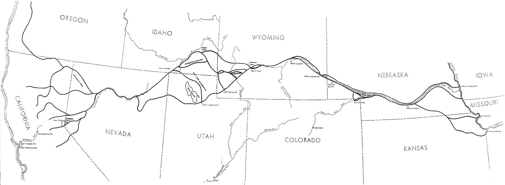
The first party to travel overland to California hailed from Platte County, western Missouri. The 69 men, women, and children were encouraged by returned trapper Antoine Robidoux who described a "perfect paradise, a perennial spring." [43] They were led by John Bidwell and John Bartleson and further assisted by trapper Thomas Fitzpatrick and Jesuit priest Father De Smet. (Bidwell recalled years later that "our ignorance of the route was complete. We knew that California lay west, and that was the extent of our knowledge.") [44] Like the parties to follow, they raced the seasons, scouting the Platte River plain for the first sign of sufficient spring grass to sustain their herds, and sprinting across country at an average pace of 15 miles per day in a desperate race to beat the snow to the Sierra Nevada (Figure 6).
|
| Figure 6. The California Trail, Missouri to the Sacramento Valley, USDI, National Park Service, Eligibility/Feasibility Study and Environmental Assessment for National Historic Trail Authorization, Washington, D.C.: United States Department of the Interior, National Park Service, 1987. (click on image for an enlargement in a new window) |
The Bidwell-Bartleson party followed the Oregon Trail as far as Soda Springs (near present day Pocatello, Idaho). Here, half the party opted for Oregon. The remainder abandoned their wagons and proceeded southwest across the tortuous, alkali "Bonneville Flats" north of the Great Salt Lake, along the trail blazed — and dismissed — by Jedediah Smith in 1827 and Joseph Walker in 1833. [45]
Other parties followed by alternative routes: via Santa Fe, via Oregon, and, in 1843, via City of Rocks/Granite Pass, by way of the Oregon Trail to Fort Hall. This later party traveled under the leadership of Walker and of Joseph B. Chiles, a member of the Bidwell-Bartleson party of 1841. At the confluence of the Raft and Snake rivers, Chiles and "a few companions" proceeded west along the Snake, to the Malheur River, and thence south to California. Walker and the remainder of the party proceeded up the Raft River, to the City of Rocks, west to the Goose Creek range, to a (barely) tolerable wagon crossing at Granite Pass — a route destined to become the main overland road to California.
This route met the basic requirements of an overland trail: it possessed a minimum of geographic obstacles (although wagons had to be lowered by rope down Granite Pass and other defiles); water was available at reasonably regular intervals, as was sufficient browse for emigrant stock; and, with the exception of the unfortunate and much-lamented loop to the north between South Pass and the Raft River confluence, the trail formed a direct line between the Mississippi Valley and the promised land. [46]
Subsequent alternatives — the Applegate Trail, the Salt Lake Alternate, Hudspeth's Cutoff — varied the route between South Pass and the Upper Humboldt, but all funneled to City of Rocks and Granite Pass. These alternates promised varied advantages: some were billed as shorter, offering emigrants the advantage of time (winter and the Sierras approached); some offered access to provisions (the barren Forty-Mile Desert, within which both man and beast had starved, approached). The advantages realized did not always comport with those promised: shorter did not always mean faster and provisions were not always available. [47]
|
Bound for California Monday, April 9th, 1848. I am the first one up; breakfast is over; our wagon is backed up to the steps; we will load at the hind end and shove the things in front. The first thing is a big box that will just fit in the wagon bed. That will have the bacon, salt, and various other things; then it will be covered with a cover made of light boards nailed on two pieces of inch plank about three inches wide. This will serve as for a table, there is a hole in each corner and we have sticks sharpened at one end so they will stick in the ground and we will have a nice table; then when it is on the box George will site on it and let his feet hang over and drive the team. It is as high as the wagon bed. Now we will put in the old chest that is packed with our clothes and things we will want to wear and use on the way. The till is the medicine chest; then there will be cleats fastened to the bottom of the wagon bed to keep things from slipping out of place. Now there is a vacant place clear across that will be large enough to set a chair; will set it with the back against the side of the wagon bed; there I will ride. On the other side will be a vacancy where little Jessie can play. He has a few toys and some marbles and some sticks for whip stocks, some blocks for oxen and I tie a string on the stick and he uses my work basket for a covered wagon and plays going to Oregon. He never seems to get cross or tired. The next thing is a box as high as the chest that is packed with a few dishes and things we don't need til we get thru. And now we will put in the long sacks of flour and other things... Now comes the groceries. We will made a wall of smaller sacks stood on end; dried apples and peaches, beans, rice, sugar and coffee, the latter being in the green state. We will brown it in a skillet as we want to use it. Everything must be put in strong bags; no paper wrappings for this trip. There is a corner left for the wash-tub and the lunch basket will just fit in the tub. The dishes we want to use will all be in the basket. I am going to start with good earthen dishes and if they get broken have tin ones to take their place. Have made 4 nice little table cloths so am going to live just like I was at home. Now we will fill the other corner with pick-ups. The iron-ware that I will want to use every day will go in a box on the hind end of the wagon like a feed box. Now we are all loaded but the bed. I wanted to put it in and sleep out but George said I wouldn't rest any so I will level up the sacks with some extra bedding, then there is a side of sole leather that will go on first, then two comforts and we will have a good enough bed for anyone to sleep on. At night I will turn my chair down to make the bed a little longer so now all we have to do in the morning is put in the bed and make some coffee and roll out. The wagon looks so nice, the nice white cover drawn down tight to the side boards with a good ridge to keep from sagging. It is high enough for me to stand straight under the roof with a curtain to pull down in front and one at the back end. Now its all done and I get in out of the tumult... [Keturah Belknap, quoted in Daniel J. Hutchinson, Bureau of Land Management, and Larry R. Jones, Idaho State Historical Society, eds., Emigrant Trails of Southern Idaho, (Boise, Idaho: Idaho State Historical Society), 1994, p. 3.] |
Junction of Trails
Fort Hall, established in 1833 by Nathanial Wyeth of the Columbia River Fishing and Trading Company and operated by the Hudson's Bay Company since 1837, was a critical point of decision for the early travelers along the overland trail. The fort was located on the south bank of the Snake River, three and one-half months travel and 1200 miles from Missouri and almost three months and 600 miles from the Sacramento Valley. The fort was the third and last trading station on the overland trail and here travelers made final preparations for the most difficult stage of their journey and final decisions on their ultimate destination.
Beginning in 1843, former mountain man Caleb Greenwood, hired by California trader, cattleman, and pioneer John Sutter to lure and guide the Oregon bound to California (and willingly granted a pulpit at the British-operated fort), proselytized to the exhausted and confused on California's greater virtues and easier access. [48] Bud Guthrie immortalized Greenwood in the Pulitzer Prize-winning novel The Way West:
[From Fort Hall to Boise] there's the Snake to ford twice. . . . The Snake ain't no piss-piddle of a river even if you might think so, seein' it from here, but you'll get over, most o' you, and maybe some wagons. . . . Damn me fer a liar if fer days you don't roll along her rim and no drink for man or brute, and there she flows, so goddam far and steep below. . .
Californy way is too by-jusus tame. Nothin' the whole length of her to test a man. Nothin' to remember 'cept easy goin'. . . . [They raise] nothin' cept what's sot in the ground and whatever chews on grass. She's a soft country, she is, and so goddam sunny a ma wonders ain't there ever no weather there. It ain't like Oregon thataway. [49]
After the 1849 discovery of gold at Sutter's Mill, Greenwood's services were no longer required. Gold proved a powerful incentive against which the promised virtues of Oregon paled.
Two days past Fort Hall, the trail split, right to Oregon, left to California. Jacob Hayden, traveling in 1852, described the decision thusly:
We arose this morning with a full determination of going to Oregon, but when we reached the junction of the road, the team stopped. Part of us, after everything was taken into consideration, concluded to try our fortunes in California; the remainder gave in and we concluded to let the oxen decide our destiny. We started them and awaited the issue with great anxiety; they turned to the left, leaving the Oregon road to the right. [50]
|
Saw some men this evening that came by the way of Salt Lake. They report that ther [sic] will be a great many emigrants detained thee [sic] till after harvest, being no provisions [sic] to be had... They also say that it is 100 miles farther to come the Lake route. [Thomas Cristy, 7/1/1850, quoted in
Wells, "History of the City of Rocks" (1990), Appendix II, p.
6]
|
Those firm in their commitment to Oregon also faced a decision at the crossing of the Raft River: to proceed on the main trail along the Snake River or along alternate routes that took them south through the City of Rocks. The direct route was damned both with insufficient water for man and stock and too much water at the deadly fords. Oregon's Blue Mountains also presented a formidable front, as did the toll road around Mount Hood. For those who could not or chose not to pay the toll, the road ended at The Dalles on the Columbia, at which point emigrants proceeded downriver, in a dangerous conclusion to their journey. In 1846, the Applegate brothers scouted an alternative to this main Oregon road. Those choosing the Applegate Trail followed the California Trail through the City of Rocks, across Granite Pass, to a point near Winnemucca, Nevada, "thence northwest over Black Rock desert and the Cascade Range into the Rogue River Valley, and thence north to Salem, Oregon." [51] As with all of the alternatives, there were tradeoffs: travelers avoided crossing the Snake and the Columbia Dalles, yet faced "appalling difficulties" in Nevada's High Rock Canyon. [52]
After the 1862 Boise Basin gold strike, wagons traveling north from Salt Lake City forged a road from the Salt Lake Alternate to "Junction Valley," where they broke north off the California Trail, following the bench above Birch Creek past the present town of Oakley, and rejoining the Oregon Trail near Rock Creek. [53]
The Salt Lake Alternate, South Pass to City of Rocks
Mountain man and entrepreneur Jim Bridger established the Fort Bridger trading post south of South Pass in 1843. Those who traveled to the fort had the option of cutting north to Fort Hall on the main road — a circuitous and unappealing alternative that added miles to an already-too-long journey — or, by 1846, of following Lansford Hastings' trail across the Bonneville Flats to the main road along the Humboldt. This latter, untenable route fell into disuse following the experience of the Donner party. [54]
|
[At the crossing of the Raft River], the Oregon and California roads separate, and we are glad to learn that only about 60 or 70 wagons, out of 750, except the Mormons, are taking the road to California. The Mormons stop at the great Salt Lake... |
By 1848, one year after the Mormon exodus from Nauvoo to the Salt Lake Basin, California emigrants in need of rest and provisions had again diverted in large numbers south from South Pass to the Mormon "half-way house" of Salt Lake City (luxuries included a shave, new eyeglasses, a bed, a good meal). From Salt Lake City, they left behind "civilization, pretty girls, and pleasant memories," and proceeded north along the Salt Lake Alternate. This route was established in 1848 by Samuel Hensley, a member of the 1841 Bartleson Bidwell party, and first traveled by H. W. Bigler's Mormon battalion, returning to Salt Lake City following the Mexican-American War. The route crossed the Bear River approximately one week (80 miles) north of Salt Lake City, cut west northwest across the southeast corner of what is now Idaho, and met the main California Trail at the south "gate" to City of Rocks. The granite monolith christened "Twin Sisters" by a member of the battalion marks this southern entrance. [55]
Mormon emigrants, years behind the 1847 hegira, also followed this alternate, leaving the main California Trail at City of Rocks, and traveling east against the grain to the Salt Lake Basin — the land "that no one else wanted." [56]
|
[Along Hudspeth's Cutoff] the whole earth shows the effects of earthquakes. The rocks are thrown out of the earth in all confused forms imaginable, filling the earth with caverns and holes, rendering it dangerous to travel for either man or beast. The rolling of our wagons over the road produces a roar that sounded as though the earth was not two feet deep. [Pigman, 1858, quoted in Cramer,
"Hudspeth's Cutoff southeastern Idaho, a map and composite diary," p.
21.]
|
In 1849, Benoni M. Hudspeth and John J. Myers blazed a route along an "old Indian trail" running from the big bend of the Bear River (near Soda Springs) to Cassia Creek in the Raft River Valley, thus avoiding the long detour north to Fort Hall and then back along the Raft River toward the City of Rocks. When Hudspeth, Myers, and the large party of Missouri miners that had employed them as guides emerged from the rugged mountains along the east bank of the Raft River (near present-day Malta), they were reportedly "'thunder struck' to find they had not reached the Humboldt at all." [57]
|
[At the head of the Raft River] "such beards & faces! — all white with dust — our animals ditto. A wash was quite refreshing. Here we had dense willows to shelter us from the cold mountain blast." [Eleanor Allen, quoted in Hutchinson
and Jones, eds., Emigrants Trails of Southern Idaho, p.
97.]
|
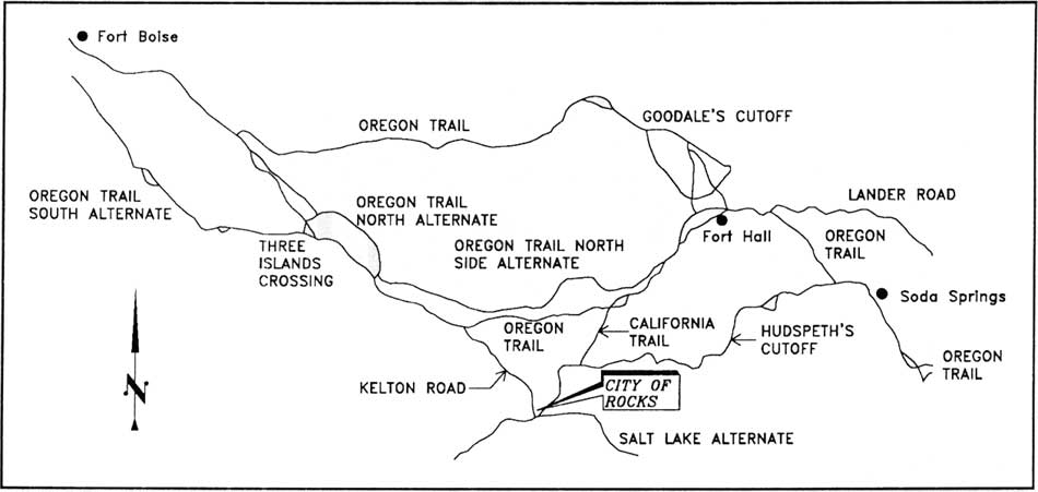
Although the route was exceptionally rugged and passable only to west-bound wagons, it saved 22 miles and a day's travel over the road to Fort Hall. To footworn men and women in a hurry, this savings was considerable. By October of 1849, General P.F. Smith recommended against establishing a permanent United States military post at Fort Hall, noting that much of the emigrant traffic traveled Hudspeth's Cutoff instead (Figure 7). [58]
|
| Figure 7. Emigrant Trails of Southern Idaho (including Alternative Routes along the California Trail). Daniel J. Hutchison, Bureau of Land Management, and Larry R. Jones, Idaho State Historical Society, eds., Emigrant Trails of Southern Idaho, 1994, inside front cover. (click on image for an enlargement in a new window) |
The City of Rocks
Between 1841 and 1860, the various overland roads funneled as many as 200,000 men, women, and children through the City of Rocks. [59] Historian John Unruh argues persuasively against "the language of typicality" in describing their journey:
it seems axiomatic to distinguish between abnormally wet and abnormally dry years. . . . The inexorable growth of supportive facilities.. further negates the usefulness of a 'typical year' approach. . . . Similarly revolutionizing the nature of the overland journey were the diverse traveler-oriented activities of the federal government: exploration, survey, road construction, postal services, the establishment of forts, the dispatching of punitive military expeditions, the allocation of protective escorts for emigrat caravans, the negotiation of Indian treaties designed to insure the safely of emigrant travel.... The California gold rush accelerated the amount of eastbound trail traffic.... Trail improvements contributed to significant reductions in the amount of time required to travel the overland route. [60]
|
One day west of the City of Rocks. Never saw such dust! In some places it was actually to the top of the forewheels! Fine white dust, more like flour. Our men were a perfect fright, being literally covered with it... |
Between 1841 and 1848, the journey from Missouri to California consumed an average of 157 days; add the years 1849-1860, and the average drops by over a month, to 121 days. After the great Mormon migration of 1847, those whose provisions, wagons, stock, or resolve had failed had the option of detouring to Salt Lake City. Prior to 1849, emigrants were primarily families of farmers, hopeful of settling — of staying — in California and Oregon. After the 1849 discovery of gold at Sutter's Mill, the wagon trains were joined by single men, unencumbered with heavy loads and hopeful of leaving California once they had struck it rich in the placer deposits of the Sacramento Valley; by 1850, both those who were successful and those who failed added a stream of east-bound traffic to the migration. [61] By 1852, the gold fever had waned and "families seeking new homes" once again replaced the fortune hunters. For those traveling between 1851 and 1862, when the threat of death from hostile Indians kept pace with the threat from cholera or accident, the journey west of South Pass was significantly more dangerous than for those who had preceded and those who would follow. [62]
|
Approaching City of Rocks Early breakfast, & soon on the trail again, — which winds up this deep valley, from S. by E. round to N.W. - An entire range on our left, of volcanic hills, for about 15 miles: and on our right, similar formations for about 10 ms. when we entered a very extraordinary valley, called "City of Castles." [J. Goldsborough Bruff (August 29,
1849), quoted in Wells, "History of the City of Rocks" (1990), Appendix
II.]
The circle is about 5 miles across one way & 3 the other, with only a narrow passage into it from the East 20 yds wide & another from the West 10 yds. Wide; the road passed through it. [John E. Dalton, July 26, 1852,
quoted in Wells, untitled manuscript, p. 49.]
|
Yet there were the constants of daily life — irrespective of the year, men and beasts needed food, water, and protection. Seven thousand five hundred mules, 31,000 oxen, 23,999 horses, and 5,000 cows accompanied the 9,000 California-bound wagons counted in Fort Laramie in 1852 — the peak year of emigrant traffic. Cut the numbers in half, for more "typical" years, and they remain impressive. These animals needed water when they "nooned" and again at the end of the day. The drain on the semi-arid West's water and browse resources was significant, necessitating that camp sites be varied and numerous and that the trail be spread over a many-mile radius, except in those areas where passage was limited to a narrow defile. [63]
At the northeast entrance to the City of Rocks, the trail constricted over Echo Gap (also called Echo Pass), and led to the Circle Creek basin. It constricted again at Pinnacle "Pass" east of Twin Sisters, and again at the head of Emigrant Canyon south of Twin Sisters, where the Salt Lake Alternate joined the main trail. Camp sites were available near "Register Rock" and "Camp Rock" where a number of springs provided water, along Circle Creek, and at the Emigrant Canyon spring. However, grazing resources at these sites would have been quickly exhausted in the late summer months when most emigrants arrived, suggesting that the Raft River Valley (east of City of Rocks), Big Cove (2 miles east of the City of Rocks, near Almo), and Junction Valley (2 miles southwest of the City of Rocks) would have been most often used as camping sites, particularly in the years of heaviest traffic and least rain. [64]
These camps provided not only an afternoon's or a night's rest, but also served as final havens of water and grass as migrants approached the long trek along the Humboldt River and the "Forty Mile Desert" past the Humboldt Sink. This was "the dreaded part of California travel, made more tragic by the weakened condition of so many emigrants and the death of so much of their livestock." [65] To avoid similar fates, trains would sacrifice precious days in the Raft River and Goose Creek regions to allow their stock to rest and feed.
Perhaps taking advantage of the brief interruption, and certainly in response to the approaching Granite Pass descent and Humboldt Desert travail, emigrants lightened their loads, jettisoning all but the essentials of continued travel: "at a fine spring and good grass we took dinner. Here the old Fort Hall road and the Salt Lake City road come together. . . . Here we overtook a company who were abandoning their wagons, and like us, packing." [66] As late as the 1970s, scattered remains of the wagons and abandoned personal effects remained within the City of Rocks. That they were only scattered attests not only to the passage of time, but to the extent to which subsequent emigrants salvaged and reused what others had left behind, especially the axles and wagon tongues used to make wagon repairs. And, as the Mormons struggled to forge a city in the wilderness, their salvage parties ranged in a wide arc north and east of Salt Lake: "especially welcome" were the tons of iron from abandoned wagons they brought back into the valley. [67]
After the establishment of Salt Lake City, life along the trail was not limited to those in transit. In 1849, J. Goldsborough Bruff encountered "2 Mormon young men....trading for broken-down cattle... They of course were from Salt Lake Valley." By the 1850s, Mormon entrepreneurs had established seasonal blacksmith shops in the Raft River Valley. Others traveled north from Salt Lake at regular intervals, to sell cheese, butter, eggs, and other perishables to the emigrants. [68]
The Lander Road, Fort Keamy to Honey Lake
The first emigrants loudly protested their vulnerability to Indians and to the disingenuous misinformation of opportunistic trail guides. They lamented the rough and unimproved nature of the road and the lack of mail and supply posts, of hospitals, and of blacksmith shops. In 1857, Congress funded survey and construction of the Fort Kearny, South Pass, and Honey Lake Wagon Road, along which the City of Rocks served as one of three primary diversion points (see Figure 7). Between 1858 and 1860, federal crews, under the supervision of William M.F. Magraw (east of South Pass) and of Frederick Lander (west of South Pass) felled trees, constructed bridges, and developed reservoirs along a crude but graded highway known to emigrants as the "Lander Road." From Soda Springs to Fort Hall, this route ran north of the old emigrant road along a more direct route, through country reportedly blessed with ample water, grass, and timber. West of Fort Hall, minor improvements provided slightly better access to the City of Rocks. Beyond the city, road improvements ultimately included an improved western descent over Granite Pass and construction of reservoirs at Rabbit Hole and Antelope Springs northwest of the Humboldt River, lessening the danger of Humboldt Desert passage. [69] Completed in time for the 1859 travel season, Lander's Road served as many as 13,000 wagons in its inaugural year.
Construction of the Simpson Road from Salt Lake City due west to the Carson Valley (roughly paralleling the abandoned Hasting's Cutoff [see Figure 6] ) also impacted emigrant travel through the City of Rocks. The road, surveyed in 1859 by Captain James H. Simpson of the U.S. Army's Topographic Engineers, saved approximately 288 miles over the northern City of Rocks route — or approximately two weeks of emigrant travel. By 1860, the road had diverted winter postal and express carriers from the City of Rocks route (an inevitable change as Granite Pass had already proved impassable in winter) and served as the primary Pony Express route to California. In a promotional battle over the two roads — a battle reminiscent of the promises made by an earlier generation of trail guides and traders — high-ranking government officials preached the virtues of the Simpson route. By 1860 the traffic from Salt Lake had increased to the point that troops were deployed to protect the emigrant trains. Simpson himself admitted, however, to the "possibility" that those "desiring to travel through to California without passing through Great Salt Lake City . . . for purposes of replenishing supplies, . . . would be best to take the Lander cut-off at the South Pass and keep the old road along the Humboldt River." [70] Thousands of emigrants agreed, bypassing Fort Bridger and Salt Lake City and keeping to the Lander Road. Briefly, however, from 1860 until 1862, construction of the Simpson Road did halt most California-bound traffic on the Salt Lake Alternate to the City of Rocks. This traffic resumed in 1862, when gold was discovered in the Boise Basin. [71]
By 1860, emigrants faced a remarkably different journey than that undertaken by their predecessors: they traveled along surveyed and graded roads, crossed the most deadly rivers by bridge or ford, and watered their stock at constructed reservoirs. Blacksmith shops and trading posts had been established and mail could be sent and received enroute. [72]
"The Indian Menace"
There was reason to hurry. Although Indian danger along the overland trail has been greatly exaggerated (many more emigrants succumbed to drowning, disease, and accident; reminiscences of overland travel are much more likely to contain accounts of massacres than daily diaries), the Northern Shoshone and Bannock Indians between Fort Hall and the Humboldt were "considered among the most troublesome of the entire trail." Ninety percent of all armed conflict took place west of South Pass. [97]
The California and Oregon trails passed through the center of the tribal country of the Bannock (a branch of the Northern Paiute) and of the Northern Shoshone. Until approximately 1851, their interaction with emigrants was friendly, if cautious. In 1850, Hugh Skinner, reported that Shoshone Indians directed his party to water. Throughout the 1840s, emigrants hired the Western Shoshone to cut and carry grass and to watch and herd emigrant stock during overnight encampments. [98] In 1851, Caroline Richardson reported that "we are continually hearing of the depredations of the Indians but we have not seen one yet." [99]
As emigrant numbers increased through the early 1850s, the drain on the tribes' traditional grazing resources intensified, leaving Indian lands impoverished. Increased emigrant numbers also spelled increased white/American Indian contact: emigrants reported a dramatic increase in the number of stock stolen, while the Indians complained of unprovoked attacks, and federal Indian agents complained of the unethical behavior of white traders "who plied the natives with whiskey and sold them guns and ammunition." [100] Bannock and Shoshone hostility was further fanned by federal overtures to other tribes. In 1858 Indian Agent C. H. Miller argued that the government owed the Bannock just compensation for the destruction of their traditional winter range and the depletion of their hunting grounds. Without such payments, Miller and the "mountaineers" with whom he had consulted believed that the Indians would attack the first trains out of Fort Hall in 1859, in a desperate bid to prevent the destruction of those resources upon which they depended absolutely. Furthermore, "it has been in the most manly and direct manner that these Indians have said that if emigrants, as has usually been the case, shoot members of their tribes, they will kill them when they can." The federal government failed to negotiate successfully with either the Bannock or the Northern tribe, and the attacks continued. [101]
Most emigrants died individually, in isolated incidents, yet it was the massacres that captured public attention. In 1852, 22 emigrants were killed in the Tule Lake Massacre, and 13 in the Lost River Massacre; in 1854, 19 died in the Ward Massacre, 25 miles east of Fort Boise; in 1861, 18 members of the Otter-Van Orman train were killed 50 miles west of Salmon Falls on the Snake River. [102] The massacres were generally attributed to the Bannock and Shoshone, although eyewitnesses, Indian agents, army personnel, and the Oregon legislature reported the participation of "out-cast whites" who "led on . . . bands of marauding and plundering savages." [103]
Although the threat of death was of greatest concern, many more emigrants would experience the loss of their livestock: "it was the art of stealing horses which, at least according to emigrant testimony, the Indians had absolutely mastered." [104] Such theft was a significant blow, depriving emigrants of a food source, a transportation source, and the oxen, mules, and horses that pulled their wagons. In 1860, while traveling along the Raft River, emigrant James Evans wrote,
Indians hostile through all this region; came around camp every night, but could not be seen during the day. They stole 50 horses from one company. We kept two men constantly with the cattle whenever they were loose, and every man who had horses kept them constantly under his eye during the day . . . Kept two men watching around the encampment during the night with double barrelled shot guns, and revolvers. [105]
Others in the City of Rocks region were not so vigilant — or so lucky. On September 7, 1860 "Indians" who spoke English well attacked a four-wagon train in the City of Rocks vicinity, stealing 139 cattle and six horses. A month later, the Deseret News reported an attack on a wagon train encamped near the City of Rocks: "except for hunger, thirst and terror there were no casualties... The emigrants did, however, lose nearly all of their possessions." [106] In September of 1862, the Deseret News reported that Indians were pasturing over 400 head of stolen emigrant cattle on land just east of the City of Rocks. [107] By October of 1862, the Virginia City Territorial Enterprise had warned that "every train that has passed over that portion of the route in the City of Rocks since the 1st of August has had trouble with the Indians." [108]
In 1860, California-bound emigrants successfully petitioned for Army protection. Lieutenant Colonel M. T. Howe and 150 soldiers from Salt Lake City's Camp Floyd assumed responsibility for the main overland trail and the Lander Cutoff. Howe established a depot at the Portneuf River from which he escorted trains along the road between Fort Hall and the Humboldt Sink, through the City of Rocks. [109]
In 1862, Major Edward McGarry's US Army expedition killed 24 Indians in the City of Rocks vicinity, in retaliation for the Indian attacks. [110] Two years later, as the Indian assaults continued, Brigadier-General Connor ordered the Second California Volunteer Cavalry to "take steps to capture or kill the male adults of five lodges of Snake Indians who have for years infested the roads in that vicinity, and who have of late been stealing from and attacking emigrants to Idaho." [111] The battle of Bear River, "the severest and most bloody of any which has occurred with the Indians west of the Mississippi" ensued on January 29, 1863. [112] Although all the chiefs involved in the battle were Shoshone, historian Brigham Madsen reports that "the significance to the Bannock [lay] . . . in the effective and merciless manner in which the troops of the United States could and did check the resistance of a hostile tribe." [113] In July of 1863, United States Indian agents and military personnel negotiated treaties with Chief Washakie and the Eastern Shoshoni and with Chief Pocatello of the Northwest Shoshoni. In October of that same year, treaties were signed with the Western Shoshoni at Ruby Valley and the Gosiute Shoshone of Tuilla Valley.
By August of 1863, four Bannock chiefs informed James D. Doty of the Utah Indian Superintendency that their people "were in a destitute condition and . . . desired peace with the whites and aid from the government." Chief Tosokwauberaht (Le Grand Coquin) and two sub-chiefs, Taghee and Matigund signed the treaty of Soda Springs on October 14, 1863. The treaty established an estimated total Bannock population of one thousand, to whom the United States government would pay five thousand dollars [114] a year in annuity goods in compensation "for damages done to their pasture lands and hunting grounds." Article III of the treaty "exacted a promise from the Bannock that they would not molest travelers along the Oregon and California trails and along the new roads between Salt Lake City and the mines near Boise City and Beaver Head." [115]
|
Perspectives from Indian Country TO THE PUBLIC: From information received at this department, deemed sufficiently reliable to warrant me in so doing, I consider it my duty to warn all persons contemplating the crossing of the plains this fall, to Utah or the Pacific Coast, that there is good reason to apprehend hostilities on the part of the Bannock and Shoshone or Snake Indians, as well as the Indians upon the plains and along the Platte river. The Indians referred to have, during the past summer, committed several robberies and murders; they are numerous, powerful, and warlike, and should they generally assume a hostile attitude are capable of rendering the emigrant routes across the plains extremely perilous; hence this warning. [Indian Commissioner Charles E. Mix,
1862, quoted in Brigham Madsen, The Bannock of Idaho, p.
128.]
These Indians [Bannock and Shoshoni] twelve years ago were the avowed friends of the White Man I have had their Young Men in my Employment as Hunters Horse Guards Guides &c &c I have traversed the length & breadth of their Entire Country with large bands of Stock unmolested. Their present hostile attitude can in a great Measure be attributed to the treatment they have recd from unprincipled White Men passing through their Country... Outrages have been committed by White Men that the heart would Shudder to record. [Major John Owen (1861), quoted
Madsen, The Bannock of Idaho, p. 124.
|
Emigrants' Response to the City of Rocks
We are creatures shaped by our experiences; we like what we know, more often than we know what we like. . . . Sagebrush is an acquired taste, as are raw earth and alkali flats. The erosional forms of the dry country strike the attention without ringing the bells of appreciation. It is almost pathetic to read the journals of people who came west up the Platte Valley in the 1840s and 1850s and tried to find words for Chimney Rock and Scott's Bluff and found and clung for dear life to the cliches of castles and silent sentinels. [73]
While descriptions of a typical trail experience, transcending the vagaries of route and year of travel, are a dangerous historical exercise the same is not necessarily true of generalizations about migrants' psychological response to their journey. Historian John Mack Faragher, in his comprehensive study Women and Men on the Overland Trail, argues that emigrant diaries reveal a striking similarity in their pattern of organization and in their emphasis. "Things they had done that day" form the third most common notation; reports on families' health, comfort, and safety, the second.
|
The City of Rocks [It] is a city not built by hands, neither is it constructed out of wood or brick, but is made of a material more enduring than either... It is, in fact, a city of rocks... The space between the rocks is sufficiently wide to admit a horse and rider, so that one can ride in between and around them. They remind one of a grave yard, so solemn the place appears, and as one rambles among these rocks it seems to him almost as if the were trespassing upon sacred ground. [Charles Nelson Teeter (September
1865), quoted in Wells, untitled manuscript, p. 40.]
During the forenoon we passed through a stone village composed of huge, isolated rocks of various and singular shapes, some resembling cottages, others steeples and domes. It is called "City of Rocks," but I think the name "Pyramid City" more suitable. It is a sublime, strange, and wonderful scene — one of nature's most interesting works... Eight miles from Pyramid City we recrossed, going southwest, the forty-second parallel of latitude, which we had crossed going north, on the eighth day of June, near Fort Laramie. [Margaret A. Frink (July 17, 1850),
quoted in Wells, untitled manuscript, p. 45.]
Camped at Steeple or Castle Rocks here is a sublime scenery to the Romantic the rocks resemble an old City of Ruins there are thousands, of names here I registered Mine on a large Rock which we named the Cast[le] Rock hotel. [Richard August Keen, June 22, 1852,
quoted in Wells, untitled manuscript, p. 48.]
|
The most common notations, however, were of things they had seen that day: "the emigrants were startled and in some cases overawed by the imposing natural landscape and strange climate through which they passed. In terms of sheer preponderance, men and women emigrants mentioned the beauty of the setting more than any other single subject." [74]
Those who traveled through the City of Rocks described the city in poetic and awe-struck detail. [75] And, as Wallace Stegner would later note, their descriptions of the "weird" configuration are striking in their consistent retreat to castles and silent sentinels. Rather than pathetic, this retreat may be a simple reality of language: they used the words they knew to describe what they had never seen. Yet their cliched adjectives do not disguise the wonderment with which they viewed the city or their extreme gratitude for the geographic diversion in a monotonous journey (Appendix A). [76]
Despite months on the trail, many had not yet adjusted to the size or immutability of the western landscape: upon approaching the vast Pyramid Circle, Helen Carpenter described a land base of "about an acre"; Lucena Parsons predicted "a few more years & then [the City rocks] will be leveled to the ground."
Carpenter wrote:
Emerging from [Echo Pass] we came into what is known as Pyramid Circle. There was perhaps a acre of partially level land with a good sized stream flowing through it. On this level, and the hills which encircled it, were the most beautiful and wonderful white rocks that we ever saw. This is known as the City rocks and certainly bears a striking resemblance to a city. To be sure it was a good deal out of the usual, for the large and small houses were curiously intermingled and set at all angles. There was everything one could imagine from a dog house to a church and courthouse. [77]
Vincent Geiger echoed:
You can imagine among these massive piles, church domes, spires, pyramids, &c., & in fact, with a little fancying you can see [anything] from the Capitol at Washington to a lovely thatched cottage. [78]
At City of Rocks, emigrants generally described what they saw, rather than what they did. Yet the logistics of the City of Rocks camping experience are easily recreated. As it had for the previous 100 days, camp had to be made and broken; the stock cared for (although the relative abundance of grass would have spared men the task of driving the herds miles from the trail); men, women, and children fed; in Indian country, in bad years, a careful watch mounted. Carpenter describes the ritual of travel, nooning, and camping:
the plain fact of it is we have no time for sociability. From the time we get up in the morning, until we are on the road, it is hurry scurry to get breakfast and put away the things that necessarily had to be pulled out last night—while under way there is no room in the wagon for a visitor, nooning is barely enough to eat a cold bite—and at night all the cooking utensils and provisions are to be gotten about the camp fire and cooking enough done to last until the next night.
Although there is not much to cook, the difficulty and inconvenience of doing it, amounts to a great deal—so that by the time one has squatted around the fire and cooked bread and bacon, and made several dozen trips to and from the wagon—washed the dishes . . . and gotten things ready for an early breakfast, some of the others already have their night caps on—at any rate it's time to go to bed.
In respect to women's work the days are all very much the same.... Some women have very little help about the camp, being obliged to get the wood and water (as far as possible), make camp fires, unpack at night and pack up in the mornings. [79]
Yet with all that, more than one woman would have echoed Carpenter's grateful "Am glad I am not an ox driver." [80] Men were charged with "the care of wagons and stock, driving and droving, leadership and protection of the family and party." On a normal day of travel:
the men of each family were up between four and five in the morning or cut their oxen from the herd and drive them to the wagon for yoking and hitching. The wagon and running gear had to be thoroughly checked over.... Normally a man drove each wagon . . . [and] some men herded and drove the stock to the rear of the line. A good morning march began by seven and continued until the noon hour, when drivers pulled up, unhitched their oxen, set the stock to grazing, and settled down for the midday meal the women produced.... Driving and droving were strenuous and demanding occupations.... Most [men] drove by walking alongside the trail. . . . Walking the fifteen or so miles of trail each day was, in the best of conditions, enough to tire any man Driving, and especially herding the cattle, meant eating large portions of dust: "It has been immensely disagreeable for the drivers today for a Northwest wind drove the dust in clouds into their faces . . . Am glad that I am not an ox driver." [81]
City of Rocks provided a welcome diversion from these travel rituals. Carpenter wrote:
While the stock was being cared for the women ad children wadered off to enjoy the sights of the city . We were . . . spellbound with the beauty and strangeness of it all. . . [82]
J. Goldsborough Bruff "dined hastily, on bread & water, and while others rested, . . . explored and sketched some of these queer rocks." [83] Young Harriet Sherrill Ward was similarly impressed. In a joyful description she painted a camp scene very different from the scenes that had preceded and those that would follow:
At eave we encamped in Pyramid Circle, a delightful place indeed. . . . Our tents and wagons grouped together and a merry party tripping the light fatastic toe upon the green, whose cheerful, happy voices echo from the hills around us, presents a scene altogether picturesque and novel." [84]
Emigrants consistently referred to the city as one of the memorable scenic wonders of a phenomenal journey: "This is one of the greatest curiosities on the road" wrote Eliza Ann McAuley in 1852. [85] Others agreed:
[Our] camp was pitched in a unique spot between Independence and Hangtown, one to be remembered along with Ash Hollow and Independence Rock for genuine singularity. . . . 'The manuscript of God remains Writ large in waves and woods and rocks.' [86]
Encamped in Granite City one of the finest natural places of its kind in the World, I banter the World to beat it. [87]
Within the Circle is one of the coldest springs seen on the route — and the Circle is surrounded on all sides with lofty mountains, covered with ever green Cedars; rendering the whole one of the most beautiful, grand. pictures[que] and delightful scenes I ever saw. [88]
|
I came to the junction of the roads [California Trail and Salt Lake Alternate], where there were many sticks set up, having slips of paper in them, with the names of passengers, and occasionally letters to emigrants still behind. [A. Delano, July 23, 1849, excerpt
provided by City of Rocks National Reserve.]
|
The City was unusual not only as a geographic oddity but also as a register of those who had gone before and as a rare and valued opportunity to communicate with those who followed. Count Leonetto Cipriani described "a cave used as a mail deposit... There were many letters, but none from the wagon company, a sure sign that it had not yet come by." The cave, at the base of what J.G. Bruff christened Sarcophagus Rock, is no longer visible, presumed buried by years of erosion and deposit. Yet elsewhere in the city vestiges of historic graffiti remain, marked with wheel grease or tar:
From the human standpoint, this Pyramid Circle is of greater interest because here we have another registration book of transcontinental travel. Rocks, walls, and monuments are covered with thousands of names and dates, and bear, as well, messages to on-coming friends and acquaintances. Some names date back to the earliest explorers. . . . The road from the Missouri River westward is lined with penciled messages or names and dates of passage. . . but Pyramid Circle is the volume de luxe. [89]
Although names and dates of travel are the dominant extant inscriptions, an occasional message remains legible, including O.E. Dockstater's terse "Wife Wanted." Emigrants also platted the city, signing rocks as "NAPOLEON'S CASTLE," and "CITY HOTEL"; those monoliths nearest the central trail were the most heavily inscribed. [90]
The larger countryside surrounding the City of Rocks, viewed in mid-August — at the end of the summer drought — was greeted with substantially less enthusiasm than the city itself. The vast majority of emigrants were "driven by a farmer's motives," and judged the passing countryside through the filter of what they had left behind in the well-watered east and what they expected to find in verdant California. They noted favorably the adequate grass along the Snake and Raft rivers but disdained the lands lying beyond the immediate water courses. [91]
In 1847, Chester Ingersoll reported:
. . . Since leaving the South Pass, it has been one entire volcanic region, all burnt to a cinder. The rock and stone look like cinders from a furnace. We have not had any rain for two months worth noticing. [92]
H.B. Scharmann cautioned:
The land . . . from Fort Laramie to California is not worth a [farmer's notice], I think. It consists of nothing but desert-land and bare mountains covered with boulders and red soil which makes them resemble volcanoes. The best thing the traveller can do is to hurry on as fast as possible from one river to the other. [93]
Leander Loomis added:
And we believe that some day there will be [gold] Discoverys made through here that will astonish the world. [I]f there is not something of this kind, in this country, it is folly in our opinions, for our Government, to try to settle it with White men, — for there is no timber through here, and if there was, there is (comparitive) no land fit for farming purposes from the Missouri to the Humboldt. [94]
Only the far-sighted recognized that grazing "would claim a high place on these lands." [95] The first generation of emigrants left their messages on the rocks and hurried to the next river, voicing no inclination to stay.
"When we had all gratified our curiosity, we bid the place adieu and rode away." [96]
"The Indian Menace"
There was reason to hurry. Although Indian danger along the overland trail has been greatly exaggerated (many more emigrants succumbed to drowning, disease, and accident; reminiscences of overland travel are much more likely to contain accounts of massacres than daily diaries), the Northern Shoshone and Bannock Indians between Fort Hall and the Humboldt were "considered among the most troublesome of the entire trail." Ninety percent of all armed conflict took place west of South Pass. [97]
The California and Oregon trails passed through the center of the tribal country of the Bannock (a branch of the Northern Paiute) and of the Northern Shoshone. Until approximately 1851, their interaction with emigrants was friendly, if cautious. In 1850, Hugh Skinner, reported that Shoshone Indians directed his party to water. Throughout the 1840s, emigrants hired the Western Shoshone to cut and carry grass and to watch and herd emigrant stock during overnight encampments. [98] In 1851, Caroline Richardson reported that "we are continually hearing of the depredations of the Indians but we have not seen one yet." [99]
As emigrant numbers increased through the early 1850s, the drain on the tribes' traditional grazing resources intensified, leaving Indian lands impoverished. Increased emigrant numbers also spelled increased white/American Indian contact: emigrants reported a dramatic increase in the number of stock stolen, while the Indians complained of unprovoked attacks, and federal Indian agents complained of the unethical behavior of white traders "who plied the natives with whiskey and sold them guns and ammunition." [100] Bannock and Shoshone hostility was further fanned by federal overtures to other tribes. In 1858 Indian Agent C. H. Miller argued that the government owed the Bannock just compensation for the destruction of their traditional winter range and the depletion of their hunting grounds. Without such payments, Miller and the "mountaineers" with whom he had consulted believed that the Indians would attack the first trains out of Fort Hall in 1859, in a desperate bid to prevent the destruction of those resources upon which they depended absolutely. Furthermore, "it has been in the most manly and direct manner that these Indians have said that if emigrants, as has usually been the case, shoot members of their tribes, they will kill them when they can." The federal government failed to negotiate successfully with either the Bannock or the Northern tribe, and the attacks continued. [101]
Most emigrants died individually, in isolated incidents, yet it was the massacres that captured public attention. In 1852, 22 emigrants were killed in the Tule Lake Massacre, and 13 in the Lost River Massacre; in 1854, 19 died in the Ward Massacre, 25 miles east of Fort Boise; in 1861, 18 members of the Otter-Van Orman train were killed 50 miles west of Salmon Falls on the Snake River. [102] The massacres were generally attributed to the Bannock and Shoshone, although eyewitnesses, Indian agents, army personnel, and the Oregon legislature reported the participation of "out-cast whites" who "led on . . . bands of marauding and plundering savages." [103]
Although the threat of death was of greatest concern, many more emigrants would experience the loss of their livestock: "it was the art of stealing horses which, at least according to emigrant testimony, the Indians had absolutely mastered." [104] Such theft was a significant blow, depriving emigrants of a food source, a transportation source, and the oxen, mules, and horses that pulled their wagons. In 1860, while traveling along the Raft River, emigrant James Evans wrote,
Indians hostile through all this region; came around camp every night, but could not be seen during the day. They stole 50 horses from one company. We kept two men constantly with the cattle whenever they were loose, and every man who had horses kept them constantly under his eye during the day . . . Kept two men watching around the encampment during the night with double barrelled shot guns, and revolvers. [105]
Others in the City of Rocks region were not so vigilant — or so lucky. On September 7, 1860 "Indians" who spoke English well attacked a four-wagon train in the City of Rocks vicinity, stealing 139 cattle and six horses. A month later, the Deseret News reported an attack on a wagon train encamped near the City of Rocks: "except for hunger, thirst and terror there were no casualties... The emigrants did, however, lose nearly all of their possessions." [106] In September of 1862, the Deseret News reported that Indians were pasturing over 400 head of stolen emigrant cattle on land just east of the City of Rocks. [107] By October of 1862, the Virginia City Territorial Enterprise had warned that "every train that has passed over that portion of the route in the City of Rocks since the 1st of August has had trouble with the Indians." [108]
In 1860, California-bound emigrants successfully petitioned for Army protection. Lieutenant Colonel M. T. Howe and 150 soldiers from Salt Lake City's Camp Floyd assumed responsibility for the main overland trail and the Lander Cutoff. Howe established a depot at the Portneuf River from which he escorted trains along the road between Fort Hall and the Humboldt Sink, through the City of Rocks. [109]
In 1862, Major Edward McGarry's US Army expedition killed 24 Indians in the City of Rocks vicinity, in retaliation for the Indian attacks. [110] Two years later, as the Indian assaults continued, Brigadier-General Connor ordered the Second California Volunteer Cavalry to "take steps to capture or kill the male adults of five lodges of Snake Indians who have for years infested the roads in that vicinity, and who have of late been stealing from and attacking emigrants to Idaho." [111] The battle of Bear River, "the severest and most bloody of any which has occurred with the Indians west of the Mississippi" ensued on January 29, 1863. [112] Although all the chiefs involved in the battle were Shoshone, historian Brigham Madsen reports that "the significance to the Bannock [lay] . . . in the effective and merciless manner in which the troops of the United States could and did check the resistance of a hostile tribe." [113] In July of 1863, United States Indian agents and military personnel negotiated treaties with Chief Washakie and the Eastern Shoshoni and with Chief Pocatello of the Northwest Shoshoni. In October of that same year, treaties were signed with the Western Shoshoni at Ruby Valley and the Gosiute Shoshone of Tuilla Valley.
By August of 1863, four Bannock chiefs informed James D. Doty of the Utah Indian Superintendency that their people "were in a destitute condition and . . . desired peace with the whites and aid from the government." Chief Tosokwauberaht (Le Grand Coquin) and two sub-chiefs, Taghee and Matigund signed the treaty of Soda Springs on October 14, 1863. The treaty established an estimated total Bannock population of one thousand, to whom the United States government would pay five thousand dollars [114] a year in annuity goods in compensation "for damages done to their pasture lands and hunting grounds." Article III of the treaty "exacted a promise from the Bannock that they would not molest travelers along the Oregon and California trails and along the new roads between Salt Lake City and the mines near Boise City and Beaver Head." [115]
|
Perspectives from Indian Country TO THE PUBLIC: From information received at this department, deemed sufficiently reliable to warrant me in so doing, I consider it my duty to warn all persons contemplating the crossing of the plains this fall, to Utah or the Pacific Coast, that there is good reason to apprehend hostilities on the part of the Bannock and Shoshone or Snake Indians, as well as the Indians upon the plains and along the Platte river. The Indians referred to have, during the past summer, committed several robberies and murders; they are numerous, powerful, and warlike, and should they generally assume a hostile attitude are capable of rendering the emigrant routes across the plains extremely perilous; hence this warning. [Indian Commissioner Charles E. Mix,
1862, quoted in Brigham Madsen, The Bannock of Idaho, p.
128.]
These Indians [Bannock and Shoshoni] twelve years ago were the avowed friends of the White Man I have had their Young Men in my Employment as Hunters Horse Guards Guides &c &c I have traversed the length & breadth of their Entire Country with large bands of Stock unmolested. Their present hostile attitude can in a great Measure be attributed to the treatment they have recd from unprincipled White Men passing through their Country... Outrages have been committed by White Men that the heart would Shudder to record. [Major John Owen (1861), quoted
Madsen, The Bannock of Idaho, p. 124.
|
The Kelton Road — "The Stage Era"
The flow of emigrant traffic through the City of Rocks ebbed after 1852 and virtually ceased following the 1869 completion of the transcontinental Union Pacific Railroad. [116] The City of Rocks remained an important transportation center, however, serving as a relay point and rest stop on the mail and stage route connecting the railhead at Kelton, Utah with the boom mining communities of the Boise Basin.
Since the founding of Salt Lake City, the Salt Lake Alternate to the Overland Trail had served as a freight route connecting the interior basin with the Pacific coast. Beginning in September of 1850, George Chorpenning and Absalom Woodward's government-sponsored mail wagons ran from Fort Bridger to Sacramento, by way of the Salt Lake Alternate and Granite Pass. [117] The route was abandoned in September of 1853, in response to harsh winters and Indian attacks, yet resumed briefly in 1858, when the Mormon War disrupted the San Bernardino route. Concord coaches or four-horse mud wagons passed through the region once a week, from July to December, 1858, when the route was again abandoned in favor of a central Nevada route west of Provo. [118]
Beginning ca. 1860, a local version of the famous Pony Express also ran through the City of Rocks, along a route that extended from Boise to Brigham City, Utah, by way of Rock Creek, Oakley, Goose Creek, City of Rocks stage station, and the Raft River Headwaters, and Kelton Pass. [119]
The discovery of gold in the Boise Basin in 1862 created a new market for Salt Lake goods, which in turn, resulted in a modification in the abandoned Chorpenning & Woodward route. Circa 1864, Ben Holladay of the Holladay Overland Mail and Express Company initiated a run from the railroad at Kelton, Utah, to Boise Basin mining communities. Holladay's coaches traveled to the City of Rocks region by way of the Salt Lake Alternate (Figure 8). Here they turned north, rather than west, proceeding over Lyman Pass (a gentle breach of the Albion Mountains), to Rock Creek along the Snake River. John Hailey of Boise purchased the Boise to Kelton route from C. M. Lockwood in 1868. [120]
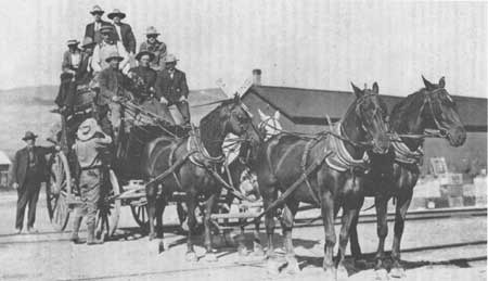
|
|
Figure 8. Concord Gulch (Idaho State Historical Society photograph
#69-161.1) Concord Coaches "revolutionized western travel... [They were] far better suited to journeys across plains and deserts than any earlier vehicle. The wheels were heavy, with broad iron tires that would not sink in soft sand, and were set wide apart to keep the stage from tipping. The iron-reinforced wooden body was swung on leather thorough braces which absorbed some of the worst shocks and was provided with leather curtains... The gaudily painted red or green vehicles were pulled by four galloping horses or half a dozen scampering mules... (Billington, Westward Expansion, A History of the American Frontier, pp. 637-638.) |
The 240-mile trip took approximately 40 hours, with stage stations strategically located 10 to 15 miles apart at sites possessing sufficient water and grass for the horses. "Home Stations" were situated approximately 50 to 60 miles apart and provided lodging for drivers and a meal for passengers.
The City of Rocks Home Station was located at the head of Emigrant Canyon, adjacent to the same spring that had induced the emigrants to establish camp. Chorpenning & Woodward may have constructed the station as early as 1858 when they "stocked [their] route past City of Rocks with stations every twenty miles or so (Figure 9)." [121]
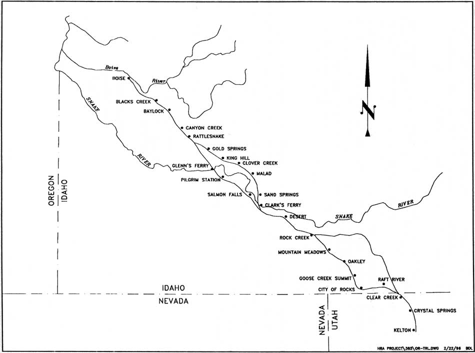
|
| Figure 9. The Kelton Road, Kelton, Utah to Boise, Idaho (HRA 1996, from David Chance, "Historical Sketch of the Kelton Road," 1993 draft manuscript prepared for the National Park Service Pacific Northwest Region.) (click on image for an enlargement in a new window) |
By the 1870s, "Mr. and Mrs. William Trotter" served five meals a day at the City of Rocks station. Driver C. S. Walgamott wrote that "the buildings were of logs and, as it was handy for material, they were built commodiously but with low ceilings. The sitting room, or barroom was about thirty feet long east and west by some fourteen feet wide. The large fireplace in the west end, the dining room, kitchen, and three bedrooms were as commodious." Beds, prepared for snow-bound passengers, were said to have been clean and comfortable and the red napkins on the tables "suggestive of everything clean and luxurious." [122]
Hailey and his successors ran the stage through the City of Rocks, between May and October, until at least 1881. During the winter months, when deep snow blocked Lyman Pass, Halley routed through traffic along the Albion freight route; intermediate service to the Goose Creek area, however, remained in effect. [123] Walgamott described that winter routine:
When I peeked out the window in the morning the snow was sifting along with the wind flurries, in places forming great drifts; and the side of the mountain looked like a rough sea of snow... I took my seat on the outrigger and at certain places indicated by the driver I would poke a willow down into the snow, just leaving the brush or part of the willow sticking up. When we encountered a drift and the leaders could plunge through we would always make it. If it was too deep the horses would always lie down, and then I would take off my fur coat and get among their legs and tramp the snow solid around them. . . We would travel east toward the Oakley station until we met the eastbound stage, which would be a coach. Here the passengers, mail, and express from the sled would be transferred to the coach, which would be turned back; and the driver who came with me would go on and I would return with the eastern driver, the eastbound passengers, and the mail. [124]
The Kelton to Boise stage route was largely abandoned by 1883, when the Oregon Short Line Railroad reached the Snake River corridor, north of the City of Rocks. In June of 1890, however, Elba resident Frederick Ottley "drove stage" between Kelton and Albion, indicating that the stage continued to service those communities isolated from the rail lines. However, this local route made no use of the City of Rocks station. [125] Circa 1921, homesteader Joseph Moon dismantled the outbuildings, using the logs in construction of his homestead. [126]
|
City of Rocks Stage Station The greatest annoyance one meets on this route is the station-houses where meals are served, as it is almost impossible to get a decent repast at any of them. The usual meal is fat ham and eggs, or boild pork, potatoes, and bread that looks as if it were baked in black ashes, while the coffee is the very vilest stuff. One place at which I stopped did not furnish any fresh meat, although hundreds of cattle were grouped around the house; and no milk although several cows with calves were within 20 yards... After a ride of 13 hours [from City of Rocks] I reached Kelton ... and was pleased to find myself on a line of railway once more. ["'City of Rocks' Impresses Early Day
Idaho Traveler," Vertical File: City of Rocks, Cassia County,
IHS.]
As it came near Christmas time, Mrs. Trotter and the woman cook began great preparations for Christmas dinner. Turkeys were ordered from Corinne, Utah, and everything on the market was sent for. The women folks made fruit cakes and prepared to make steam pudding and mince pie... [Christmas day] we meet the stage on time and when we, on our return trip, arrived at City of Rocks we were met with all kinds of Christmas greeting, and on that Christmas evening, sixty years ago, we sat down to a Christmas dinner that only youth and vigor could do justice to. After a meal we went into the living room, where Glove-Maker Jim had erected a Christmas tree, and decorated it with cranberries and pop corn, and on its branches hung little tokens of remembrance to each one present... An old fiddle was brought out and the ladies sang as I played and Jim kept time by tapping a scribe-awl on a carpenter's square. [C. S. Walgamott, Six Decades
Back, 1936, p. 27, on file at the City of Rocks National
Reserve.]
|
Buried Treasure
[While touring City of Rocks] I was startled by the appearance of three men, who were digging at the base of a crag [for a treasure] supposed to have been buried somewhere in the vicinity about two years previously by a party of highwaymen who had robbed the Montana stage. . . . The present party had undertaken the search and had been at it then for two months. . . . As a last resource, had consulted a medium or clairvoyant, and they were then plying pick and shovel where she had recommended them. . . . This incident completed the picture of the city for me for it was the only thing lacking to give it the air of wild romance which so readily accorded the lonely enclosed landscape. [127]
Tales of stage robberies complete with lost loot buried beneath one of the City's rocky crags have formed part of local lore for almost 120 years. Although versions of the robbery differ, most agree that the Kelton stage was robbed circa 1878 of $90,000-200,000 in gold bullion bound for a U.S. military camp in Boise. One bandit (in some accounts, two) was killed in the confrontation. The second was captured days later after reportedly burying the treasure at the base of what soon became known as Treasure Rock — a site revealed to his jailers just before his death. The legend is plausible — the Albion-Kelton stage was robbed, for example, in 1882 and the robbers captured in the vicinity; so plausible, that by 1929 "dozens of men [had] dug for the treasure. If any one of them discovered it, he has kept the discovery a secret." [128] Since 1880, the Legend of Treasure Rock has provided the "air of wild romance which so readily accord[s] the lonely enclosed landscape." [129]
Open Range Cattle Industry
[We] decided to lay over for several days in order to rest our cattle before entering the Snake desert. The mountains here afford a magnificent summer range, the bunch grass waving like a wheat field and with water abundant. [130]
The "pioneer" herdsman in the Raft River region were American Indians, who first grazed large herds of horses and later the cattle procured from overland emigrants; long after the Indians had been ushered to Fort Hall, these wild herds roamed the City of Rocks region feeding on the native bunchgrass (agropyrum spicatum), white sage (artemisia cana), buckbrush (Antelope Bitterbrush; purshia tridentata) and shadscale Atriplex Confertifolia)." [131] By the 1850s, the captive and inflated market of the California mining camps had attracted eastern stockmen, who drove their herds of Texas longhorns and (less often) sheep to the Sacramento Valley by one of three routes: the Gila and Old Spanish trails through Arizona and southern California and the Northern Trail, along the emigrant trail through the City of Rocks. [132]
As Richard Dana and the other California boosters had promised, the Golden State's agricultural potential was enormous. When in the 1860s the West's gold camps shifted from the Sacramento Valley to Idaho, Nevada, and Montana, California ranchers were ready to herd their cattle "east." Here they competed with the Texas ranchers for a share of the Boise Basin, Pierce, and Virginia City markets. [133] The California stock drives traveled from Junction Valley to the Raft River Valley along Trail Creek, through the City of Rocks; Texas drives passed just east, through the Raft River Valley.
By the 1870s, cattle competed with sheep on these eastward drives. California sheepmen most commonly trailed their bands on one of three routes: along Goose Creek (west) through Oakley; along the California Trail through the City of Rocks, and east along the Salt Lake Alternate. [134]
"Cattle Dealer" James Q. Shirley was the first non-Indian to use the City of Rocks as a home base. In 1869, Shirley and his "hired man" trailed 13,000 head of Texas longhorns to "a place called the City of Rocks." Here they "made camp," raising a garden and utilizing "The Cove" below Graham Peak as a natural corral. When the census taker knocked in the spring of 1880, Shirley shared the City of Rocks camp with seven "stockherders." The Keogh brothers purchased Shirley's cattle and landholdings in 1881, forming the Keogh Ranch. [135]
Neighboring cattle ranches included the Emery Ranch in the Raft River Valley, A. D. Norton and M. G. Robinson's outfit along the Snake River at Rock Creek, and the Shoe Sole and Winecup ranches located in the Goose Creek Valley west of the City of Rocks. (By 1882, the Winecup ranch alone had 175,000 cattle ranging from the Goose Creek Mountains (Albion Mountains) on the east to the Bruneau River on the west.) These operations used the City of Rocks region as summer range for their cattle and ranch horses, constructing stock ponds, corrals, and the "line cabins" that provided food and shelter to herders. [136]
By the 1880s, the Raft River Valley, with its abundant plantings of alfalfa hay, "became known as the best place in the west to winter sheep... There were free open range privileges and the general area was safe for the bands." Sheepmen, primarily headquartered in northern Utah, also relied upon the Goose Creek Range and the City of Rocks as summer range. [137]
Stock trails historically included that from Junction Valley to the Raft River Valley, along Trail Creek; a trail up the Raft River Valley to Starrh's Ferry, on the Snake River north of present Burley (from which cattle and sheep were shipped to the Wood River Mining District near Hailey); and a trail roughly following the Kelton Road, leading to shipping points on the Union Pacific Railroad. [138]
The drought of 1886-1891 and the endless winters of 1882, 1886, and 1889 brought "years of continual overgrazing" and winter range use to a screeching halt. [139] The "old time cowmen" reported losses of 50 to 90 percent during the winter of 1882. The Winecup, which branded 38,000 calves in 1885, branded 68 in 1891; the nascent local sheep industry was similarly devastated. [140] In one of the West's great ironies, the fenced fields of the settlers — anathema of the free range cowboy — saved the Idaho stock industry:
The necessity of providing feed for range stock under Idaho conditions was learned by bitter experience in the 80's and put into practice during the 90's. The change increased operating expenses but put the range industry on a safe and sane basis. . . . The cattle are winter fed. Operation costs are greatly increased but the cattle are improved and the danger of heavy losses removed. [141]
Settlement
The whole intention of those trains was to get an early start, as soon as the grass greened up, and then get through the West as fast as possible. The Mormons were an exception, a special breed headed for sanctuary in the heart of the desert, a people with a uniquely cohesive social order and a theocratic discipline that made them better able to survive. [142]
Forty years after the wagon trains first rolled west, the City of Rocks had become a place of settlement as well as a place of transit. It was home to Mormon families that expanded the cordon of Mormon influence beyond the central cultural and political core of the Salt Lake Basin/Wasatch Range, to a Mormon "domain" that ultimately encompassed all of Utah and much of northern Arizona and southern Idaho. [143] Mormon President Brigham Young had not favored the Snake River plain, believing that "the farther north we go the less good characteristics are connected with the valleys." [144] Young feared the cold winters but most importantly, he feared the good grass — already claimed by Gentile cattle barons and certain to attract even more. Thus, in contrast to the church-directed expansion to Arizona and the Utah hinterlands, settlement of southern Idaho between Fort Hall and the Utah border was not a Church-directed exodus, but rather a search by the Mormon faithful for land and livelihood. [145] Thomas Edwards arrived first, working briefly as a cattlehand on the Sweetzer Brothers' Raft River Ranch and on the E.Y. Ranch; with tales of adequate water, abundant grass, abundant land, and winters less harsh than Brigham Young had feared, Edwards enticed Henry R. Cahoon, Myron B. Durfee, William Jones, and their families to the area. Thomas King and family followed soon afterwards; King had viewed the land as a teenager and was familiar with its virtues. (Long-time Almo resident Etta Taylor would later term King's visit "the first known date of Almo.") [146] Charles Ward, informed of the area by friend William Jones, was similarly "pleased with the area's possibilities as a stock country." Mr. Ward "in turn persuaded Mr. John O. Lowe and David Ward . . . [and] Mrs. Lowe persuaded Robert Wake" to join the burgeoning community of Mormons along the banks of Almo, Grape, and Edwards creeks. [147]
A similar exodus, of friends and family, north from Utah, occurred throughout southern Idaho; by 1870, an estimated 3,000 Mormons were reported to live in a roughly defined area south of Fort Hall, Idaho, and north of Utah's Box Elder County. [148] This settlement was concentrated in the lowlands "along the streams and almost every important spring." [149]
The first General Land Office surveys show only limited development within the immediate boundaries of what is now the City of Rocks National Reserve. [150] In his 1878 survey of the east half of Township 15S 24E, Allen Thompson noted only an unnamed road along the general route of the California Trail. He described the southern township as "gently rolling" with "second-rate [soil], good grass and scattered sage" while reserving the accolade "agricultural land" for the north half of the township near Circle Creek — land soon claimed by the city's first homestead resident, George Lunsford. [151] Subsequent project-area surveys dated 1884, 1886, and 1892 note the "old California Road," roads over Lyman Pass "to Oakley," "from [the Emery] Canyon road to Junction Valley," and "to timber," as well as scattered corrals and scattered buildings, their placement without exception dictated by the presence of water. [152]
Formal claim to the best of the public domain — along the water courses in the flat lands east of the City of Rocks — quickly followed the survey crews. By the mid-1880s, presumed-cultivable and irrigable land had been claimed under the Homestead Act of 1862 and the Desert Land Act of 1877. [153]
In 1862, Congress passed a land act that "breathed the spirit of the West, with its optimism, its courage, its generosity and its willingness to do hard work." The Homestead Act of 1862 promised 160 acres of public land to those heads of families, 21-years of age and older, who were, or who intended to become, American citizens. Only surveyed agricultural lands were available under the Act; however, throughout the unsurveyed West, including southeastern Idaho, farmers "squatted" on their intended farm, filing legal papers on the heels of the survey crews. Within six months of paying their $10 filing fee, settlers were required to live on the land; thenceforth, they were required to inhabit the site, in a cabin no smaller than 12' x 16', for at least seven months of every year; the remaining five months could be spent off the land — and often were, as men and women returned to lower elevations, schools, and wage labor. After a minimum of five years of seasonal habitation (and a maximum of seven) and upon proof of cultivation, the United States of America conveyed legal title to the homesteader. [154]
Arid western lands, void of timber and uncultivable without irrigation, could also be claimed under the Desert Land Act of 1877, amended in 1891. The 1877 act allowed claims of 640 reasonably-compact arid acres, at a cost of .25 per acre at the time of filing, and $1 per acre three years later, at the time of final proof when, ostensibly, the land had been reclaimed. In practice, and in large part due to the "well-nigh impossib[ility]" of irrigating such large tracts, few claims were ever patented. General Land Office Commissioner McFarland "complained that the lands were being held for grazing without settlement and without costing more than the original 25 cents an acre paid when the application was made." [155] In 1891, Congress amended the act, requiring that detailed plans for irrigation systems be submitted and that $1 per acre be spent in each of the first three years of development. This labor and money could be shared by communal ditch associations but could not be undertaken on behalf of others — whether corporate or individual. [156]
Of the numerous Desert Land Act claims filed on land encompassed within what is now the City of Rocks National Reserve, all but two were abandoned or relinquished. [157] The remainder most likely provided spring and summer pasture for the herds of those settled outside the city, in the Almo and Elba basins. Within these basins, mostly Mormon settlers cultivated land patented under both the Homestead and the Desert Land acts; they irrigated this land through the communal ditch systems that remain the Mormons' most remarkable contribution to the western landscape. One hundred and thirty years after the Saints' arrival, land in the Raft River Valley has been leveled, cleared of willows and sagebrush, and planted in alfalfa, grain, potatoes and beets. The creek and river beds run dry, drained by the orderly system of ditch networks.
Agricultural Development of the Lowland Valleys
Most of the soil in the [Almo] valley is very fertile and especially adapted to raising lucern [alfalfa (English)]. But the scarcity of water prevents a dense population. [158]
In 1878, Henry R. Cahoon, his young wife Annie Durfee Cahoon, his father-in-law Myron B. Durfee, and Myron's large family settled along Almo Creek with the intention of farming. "Stockmen" told them and those who followed that they "could not grow anything here," [159] that the "snow would bury [them]." [160] By 1882, 35 Mormon families had "proved to the contrary." Henry R. Cahoon boasted that:
Last year we raised about 5600 bushels of wheat, oats, and barley, 1500 bushels of potatoes of the best quality . . . There is land here for a good many more settlers, and about 12 miles southwest of here is what is called Junction Valley; there is room for 20 or 30 families (so come along ye homeless). [161]
Church chronicler Andrew Jensen sounded a more cautious note: "If water was more plentiful in this valley, there would be land and all other facilities to sustain a large population." [162]
Land now encompassed by the City of Rocks National Reserve, sandwiched between the productive Almo Creek and the promising Junction Valley, is conspicuously absent in Cahoon's account — yet validated Jensen's warning; only limited pockets of land within what is now the reserve were claimed in the first wave of settlement.
In 1882, Iowa farmer George W. Lunsford claimed irrigable land along Circle Creek and the right to the water therein; in 1901 he sold his developed tract to William Tracy who developed the Circle Ranch on this and adjoining land. George Davis filed claim to the upstream tract ten years later. In 1901, Mary Ann Tracy claimed 160 "Desert" acres downstream from Lunsford's original claim, testifying that this land would not, "without artificial irrigation, produce an agricultural crop of any kind in amount reasonably remunerative . . . the same is essentially dry and arid land." Construction of storage reservoirs along intermittent North and South Circle creeks ultimately allowed successful cultivation of oats, barley, and alfalfa; the remaining acreage was relegated to spring and summer range for the Tracys' cattle. Margaret Hansen also filed a Desert Land Act claim in 1909, irrigating her fields of alfalfa, wheat, and rye with water conveyed by reservoir and ditch from South Circle Creek. In a delayed conclusion to the first phase of area settlement, Eugene Durfee [163] patented 160 acres at the eastern gateway to the City of Rocks in 1919. This land was reportedly planted in water-intensive corn, beets, potatoes, and alfalfa suggesting that Durfee had constructed an irrigation system. [164]
|
The big event was when the threshers came to thresh Dad's grain [ca. 1910]. It was a huge machine. It took about 8 teams to turn it. The teams were placed in a big circle with a man sitting in the middle to drive. He used a bull whip to pop them if they didn't pull evenly. It took 2 men on the stack to feed the machine, 2 men to catch the grain, and 2 men to hall [sic] the grain to the granary. Dave Durfee owned the thresher. He took his pay in grain. Neighbor helped neighbor. They worked from sun-up till sun-down. Mother had to have help to cook for the crew... |
By 1909, the agricultural zone watered by Circle, Almo, Grape, Edwards, Cassia, Marsh, Basin and Circle creeks consisted of almost 12,000 acres of irrigated farm lands, surrounding the communities of Almo, Ward, Elba, Basin and Albion [165] These lands supported primary crops of hay (native, timothy, or alfalfa) and grain (barley, oats, and wheat). The hay, barley, and oats provided winter feed for ranchers' sheep and cattle; sold to Hailey's Kelton-Boise stage company, the hay also served as an important cash crop. Wheat provided flour and a medium of exchange for "other necessities."
Fruit and vegetables were also successfully grown, primarily for home use due to limits to the transportation infrastructure. Potatoes were an exception — easily transported to the mining communities of Wood River (Hailey) and Boise Basin, they served as one of the few non-grain crops readily converted to cash. Pigs, chickens, and dairy cattle provided additional subsistence and additional assets with which to barter in the local economy. By the 1920s, cheese factories and creameries in Albion, Almo, Burley, Oakley, and Winnemucca, Nevada provided a market for milk and cream; longtime resident Jake Bruesch recalled in a 1974 interview that, circa 1920 "Albert Tracy brought in a herd of Wisconsin cows, Holstein cows, . . . and a bunch of us bought 'em — five or ten or fifteen each . . . and started to milk 'em and bought separators and separated milk and sold the cream for a good many years." By the 1940s, local resident Bernus Ward reported that, aside from those few ranchers with large cattle herds, "the chief income of the farmers here comes from their milch cows." [166]
|
...I remember [a]... time when Art and Fred had me straddle a neck yoke tied to the derrick cable. They played like I was a load of hay. They were the horses and would pull me to the top of the derrick and then let me down. It was fun to be up in the air 30 or 40 feet, just dangling. I felt like a bird, I was thoroughly enjoying it, laughing and yelling when Dad heard me and came to investigate. When he saw me at the top of the derrick he let out a yell. Fred and Art let go of the cable like a hot potato and headed for the top of the field where they were safe... I got the swat and was sent to the house. [Life Story of Bertha T. Kimber,
n.d., City of Rocks National Reserve.]
|
In his 1888 testimony for final patent of his homestead, George Lunsford claimed ownership of a wagon, a plow, a harrow, a shovel, a hoe, and little more. With these rudimentary tools, he had cleared and planted 20 acres in wheat, oats, barley and potatoes. [167] He most likely harvested this first oat and barley crop with a cradle or a horse-drawn dropper, and then gathered and bound the grain by hand; if he was lucky, he or a neighbor had a "self-rake reaper" to cut and rake the grain.
By 1909, years after Lunsford had left the area, "two or three individuals" in Almo purchased horse-drawn binders; "during harvest season they went from farm to farm binding grain. [168] The threshing process followed a similar technological evolution:
The first threshing was done by the tramping of horses' feet. In a short time, however, the threshing machine was brought in. It was run by horse power and had belts to carry off the straw. It was not until the last two decades [ca. 1925-1945] that the "blower" was used to eliminate the straw. In the last three decades gasoline engines have replaced the horse power. [169] (Figure 10)
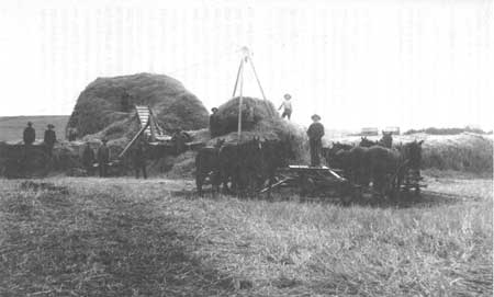
|
|
Figure 10. Horse-drawn Thresher (Idaho State Historical Society
photograph #1274-C) "The small threshing machine and tread power worked very well, after they learned to operate the outfit. They threshold from 100 to 150 bushels of grain in an eight hour day. Two gentle horses were trained to tread the power, each one was used a half day. Four hands could easily operate this thresher—a bundle pitcher, the table feeder, grain measurer and straw pitcher. The children took care of all the work except the feeding, which the father or some older man did. It worked so nicely that neighbors came to watch curiously first, then to help and beg to have their grain threshold." (Lind, "History of ...," p. 41.) |
Residents harvested hay (native, alfalfa, or rye) — first by hand, then with reapers, finally with bull rakes. Cable (or "Mormon") hay derricks or beaver slides were used to stack the "hundreds of tons of hay" put up in the valley (Figures 11 and 12). [170]
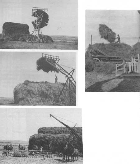
|
|
Figure 11. Hay derricks (Idaho State Historical Society photographs,
#60-52.137-140). The haying was done all by hand. It would be cut and then piled. They used what they call...cable derricks. Then finally the grain was cut with reapers...it was a long time before they got anything like bull rakes or anything like that. (V. Tanner, interviewed by Verna Richardson, August 22, 1973. |
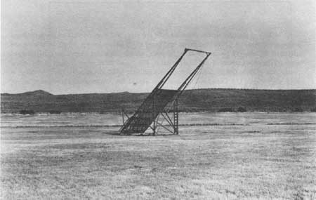
|
| Figure 12. Beaver Slide (Idaho State Historical Society photograph, #77-5.158). |
Agricultural Development of the City of Rocks - Dryland Farming
Beginning about 1908, settlers by the hundreds flocked into the areas surrounding the Minidoka Forest homesteading anything which could possibly be considered tillable Many settlers made a success of dry-farming for a few years due to very favorable rainfall conditions and good wheat prices. . . . Then, beginning about 1920, years of normal or subnormal rainfall occurred and this, together with the abrupt drop in wheat prices in 1920 and 192], finished the dry-farming boom. Hundreds of thousands of acres of land were abandoned. [171]
Without irrigation, the successful growing of crops [in Cassia County] generally has proved impossible. [172]
With the exception of Circle Creek bottomlands, City of Rocks lay beyond the fertile pale of the area creeks and protected valleys. Throughout the first wave of settlement, it remained public domain, utilized as upper-elevation spring and summer range by those farming the valley bottoms (Figure 13). The earliest settlers disdained this land as uncultivable; when the valley bottoms had been claimed (ca. 1900), Thomas King advised his eldest son to go to Alberta, Canada, where the land was "still new." [173] This view of the City changed dramatically with Idaho's inclusion in the 1909 Enlarged Homestead Act (June 17, 1910) and the arrival of the dryland farmers.
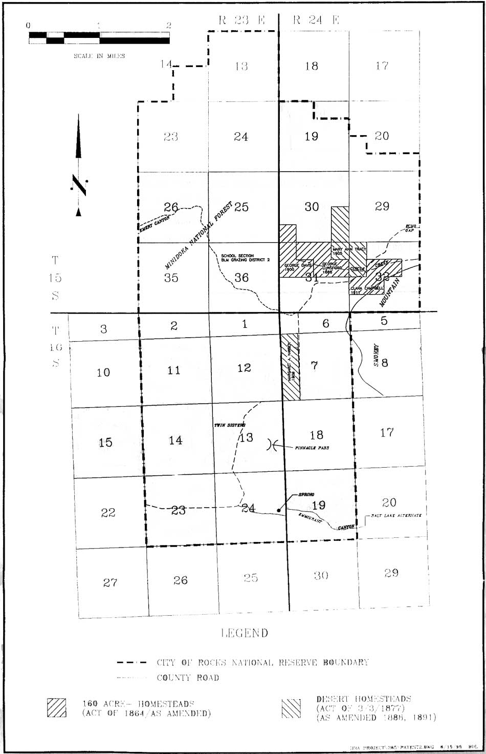
|
| Figure 13. Pre-1910 Homestead and Desert Land claims within the City of Rocks National Reserve. (click on image for an enlargement in a new window) |
Cultivation of the arid lands west of the 100th meridian demanded crop varieties and farming methods foreign to emigrants from the well-watered fields of eastern America and northern Europe. Yet to the booster and the optimistic farmer, what the arid American West lacked in rainfall, it compensated for in abundant acreage available to the landless through a variety of public land laws. When the 160 acres allowable under the Homestead Act of 1862 proved insufficient for successful cultivation or stockraising in the arid West, the figure was adjusted to allow for claims of 320 cultivable acres — the Enlarged Homestead Act of 1909.
This act inspired and sustained the dry-farm movement of the early twentieth century. By means of alternate cropping and fallowing, increased mulch, use of suitable grain strains, and modified plow methods, agricultural scientists believed (and tax-hungry western boosters proselytized) that non-irrigated lands receiving between 12 and 16 inches of rainfall per year could be made to yield profitable harvests. Agricultural Experiment Stations established on the plains circa 1905 "proved" the West's suitability to this farming method; the Enlarged Homestead Act simply provided the minimum acreage necessary for alternate cropping and fallowing, bringing overgrazed range land "into productivity in [a] new form." [174]
The dry farm movement also corresponded roughly with passage of the Forest Homestead Act of June 11, 1906. Designed to combat hostility toward the creation of National Forests, the act allowed 160-acre homestead claims on National Forest land with "agricultural possibilities." Between 1906 and 1915, 18,000 western settlers claimed 1,900,000 acres under the Forest Homestead Act. [175]
Years of plentiful rainfall sustained both the crops and the optimism of the agricultural scientists and the settlers. "The government land [was] nearly all . . . taken up, crops [were] sown and harvested, the once raw country [became] homelike, and the 'smile that won't come off' [found] its place on the countenances of 'dry land farmers.'" The project failed when drought hit the central plains circa 1918; at Oakley, annual precipitation fell from 16.07 inches in 1912 to 8.57 inches in 1919. By 1922, the U.S. Department of Agriculture warned that 320 acres were inadequate "except under the most favorable circumstances and expert management." [176]
Of the 27 patented tracts within the City of Rocks National Reserve, 19 were dryland farms claimed between 1910 and 1919 — an era initiated by Idaho's inclusion in the Enlarged Homestead Act and terminated by the drought of the 1920s (Figure 14). The City's dryland farmers were joined by Charles Freckelton and Thomas Fairchild, who joined the rush for "anything that could be considered tillable" when they each claimed 160 acres under the Forest Homestead Act of 1906; their claims were only two of the eighty filed for Minidoka National Forest lands between 1908 and 1917. [177]
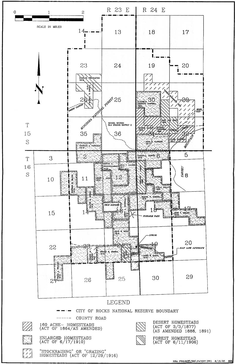
|
| Figure 14. Patented Homestead Claims within the City of Rocks National Reserve, 1888-1929. (click on image for an enlargement in a new window) |
By 1910, the Junction Valley school (southwest of the City of Rocks) "buldged [sic] with [new] students. . . . [Their parents] were going to dry farm. Already hundreds of acres had been plowed and plants. Roads were being fenced off. People would now have to drive on section lines." [178] By 1917, Junction Valley had become "a very industrious common wealth" with a store, a post office and two schools. [179]
Virtually without exception, these Enlarged Homestead and Forest Homestead claims were marginal enterprises centered on marginal land foresworn by the first wave of settlers. Claimants described their land as rough, rocky, and mountainous. After being grubbed of sage and cleared of stone, acreage was most often planted in the traditional dryland crops of winter wheat, flax, or barley; these crops were supplemented with small spring-irrigated subsistence gardens and oat fields (Figure 15). Patent records for the City of Rocks indicate that planted acreage was small, rarely exceeding 100 acres and more often totaling less than 30. Yet much of the land not planted was fenced, thereby dramatically altering neighboring ranchers' access to what had been spring range. [180]
Crops were tended and harvested between May and November, at which time the majority of area settlers reported that they returned to more-permanent homes in neighboring towns so that their children could attend school and they could seek wage employment. In their final testimony to the General Land Office, patentees repeated the litany: "I went each time to get money to go ahead each summer." [181] Presumably, the chickens, pigs, milk cows, horses, and range stock followed, to the urban "barn yards" that historically characterized Mormon towns. [182]
By any standard, the reserve would have been difficult to occupy during the winter months. Walter Mooso explained his predicament in a 1973 interview. For three difficult winters "we stayed there, right there, and I put up this rye hay." By winter four, Mooso moved his wife and two children "down every fall . . . because the snow's awful deep and [not] too much feed there and I had no work only the trapping." In testimony to the difficulty of making a living from dryland farming, Mooso abandoned his homestead shortly after proving up, for a "good job" in the Burley sugar factory. His son Lyonal remembers "Dad left because it was pretty hard picking for him. I don't ever recall dad saying that it was any good." [183]
Thomas Shomaker reported to General Land Office agents that "very bad brush and some rocks to be cleared m[ade] the cost of putting in cultivation around 11 dollars an acre including harrowing, leveling and other operations." From this toil, area dryland farmers hoped for "20-odd" bushels to the acre from the half of their already-limited acreage not left fallow. [184] Twenty-bushel yields, sufficient feed to winter limited stock, and a profit were occasionally realized through 1918, when annual rainfalls hovered near 13 inches and when wheat prices escalated in response to World War I shortages. By 1922, drought would reduce these yields to as little as two bushels per acre or to "failure." [185]
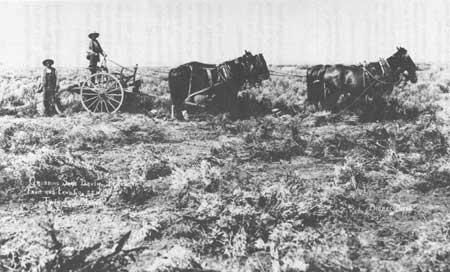
|
|
Figure 15. Sagegrubber (Idaho State Historical Society photograph
#72-221.822/b). First the trees and brush were cleared from a desirable spot... This was a back tiring and tedious job. The brush to be grubbled, piled and burned. The ground was plowed with hand plows pulled by horses. After plowing the ground was worked with hand made harrows... After the ground was harrowed it was leveled. The clods were broken and smoothed down. The remaining were removed. The holes and ditches were filled with what was called a leveler. This was built simply of boards nailed together in a square. A heavy weight was placed on the top and it was pulled over the harrowed ground... The grain was then hand sown. (Ward, "History of Almo, Idaho," pp. 12-13.) |
Crops were also vulnerable to cyclical overpopulation of rabbits and ground squirrels: rodents took Thomas Fairchild's 12 acres of grain in 1913, John Flower's 40 acres of barley in 1914 and 1915, and James Eames' 20 acres of barley in 1915 and 1916. Those crops not devastated by the rodents or the heat of August were vulnerable to the occasional heavy frosts of September and heavy snows of October. [186]
|
A little animal abounds in this region called the prairie squirrel. It is smaller than the common black squirrel, and gray in color. We see hundreds of them every day and they are often killed with clubs and whips. I first noticed them in the vicinity of Fort Laramie and have seen them every day since. [C. W. Smith, quoted (1850) in Howard
Ross Cramer, "Hudspeth's Cutoff southeastern Idaho, a map and composite
diary," 1969, p. 21.]
|
And drought affected the springs upon which City of Rocks residents relied for domestic water, subsistence gardens, and limited irrigation. Alta Mooso Weldon, daughter of homesteaders Walter and Helen Mooso, remembered that "suddenly, the underground water disappeared in 1920 ... One by one, ... settlers [Sparks, Moon, Osterhout, Wilcox, Mikesell and Mooso] abandoned their land, took their stock and household goods, moved out of the City of Rocks and took up new residences in Almo and down in Burley." [187]
The drought — and the exodus — continued through the depression of the 1930s. Despite the promises of the land agents and the optimism of early settlers, land within the boundaries of the City of Rocks is once again valued primarily as uncultivated, unirrigated range land, as the functional and geographic extreme of a system of land use centered in the home ranches and Mormon communities of the irrigated lowland valleys. Despite the concentrated historic settlement, vestiges of agricultural endeavor and of habitation in the reserve are now limited to artifact scatters, foundation stone, and the faint outlines of differential land use.
|
"Desert Ranch: Have Faith in God and U.S. Reclamation." [Handwritten sign in cover photograph, Sam Hanson et at. Hard Times in Idaho Between the Great Wars, Idaho State University Press, 1985.] |
One has only to travel through the foothills or mountains of [this] country to discover abandoned homesteads. Sometimes there will be a cabin, its door ajar or missing. More often one finds only an orderly arrangement of flat rocks . . . There may be a yellow rose bush, a few dead or dying fruit trees or a scattering of wild strawberry plants beside a almost dry creek bed where once a mountain stream overflowed. [188]
These vestiges — rather than the sustainable enterprises — may well be the most important and compelling reminder of the homestead era in the semi-arid West. The vast majority of all Desert Land claims were never irrigated, cultivated, or permanently inhabited, but were instead used as range land. More than two-thirds of all dryland claims were relinquished before going to patent; half of the West's patented Enlarged Homestead claims were ultimately abandoned. [189]
Within the City of Rocks, the list of relinquished claims dramatically exceeds the list of patented claims, with some parcels inhabited by three or more families before final proof was made or before the land reverted to the public domain or to the county; [190] presumably each claimant bequeathed at least minimal improvements to subsequent inhabitants, creating layers of cultural resources and of land use. Cassia Creek settlers Frederick, Hans, and Henry Ottley twice walked away from grubbed fields and shallow ditches; Tory Campbell abandoned a one-room frame house, 50 cleared acres, and 240 rods offence on the eastern edge of the City of Rocks upon conceding that all but 60 acres of his 320-acre claim were "rocky and unfit for cultivation." [191]
On the patented claims, there is every evidence of construction, seasonal habitation, and cultivation — of substantial (albeit fleeting) settlement where residents could see the lights of their neighbors' farms, where houses, corrals, windmills, chicken coops, and fence lines dotted the landscape (Appendix B). The crumbling foundations and scatters of domestic debris are fitting reminders of this failed endeavor.
Stockraising
As a boy in the middle eighties I can well remember the heavy stands of grasses on the ranges . . . and on these lands my father grazed stock which I helped to handle, and I have run stock on some of these lands ever since.
In afew years I watched these same ranges being fast depleted . . . Even under these conditions the stockmen did not seem to realize that the ranges would be completely ruined but kept them way over stocked with sheep, cattle, and horses.... The higher mountain areas . . . [were] practically the only watering places left open by the dry farmers and was little more than complete dust beds. About this time we heard the Government was establishing Forest Reserves and [was] going to regulate and control the grazing on these summer ranges, and this was done, but there was still too many stock for the range, and it took quite a few years to reduce the number where the range had a chance to improve. . . . Where thousands of cattle and sheep were grazed in the early range days, and beef and mutton finished on the range, a small number now exists through a short summer period, must be placed in pasture in the early fall, and finished in feed yards for the market. [192]
The City of Rocks' most consistent and economically successful usage has been as range land. In 1880, residents of the Marsh Basin (Albion), Elba, and Almo enumeration districts described themselves most often as ranchers. The economic success and the subsistence of these communities was in large part dependent upon cattle and sheep run on public land; agricultural endeavors were designed primarily to provide a family's subsistence and to sustain their herds during the winter months.
The droughts and winters of the 1880s and 1890s and the arrival of homesteaders within the watered valleys had ended the open-range cattle industry; neither, however, had dramatically affected stockmen's summer use of the non-cultivable, unsettled, high-elevation summer range, of which the City of Rocks was a part: "The range was considered free, with the only means of control by ownership or occupancy of the watering places." [193] Until the articulation and implementation of a national range conservation program, Snake River basin ranchers continued to overstock and overgraze this range, with little respect for growing seasons or carrying capacity. The circa 1890 arrival in force of sheepmen (many of them Mormon) to the basin heightened the conflict over increasingly rare and increasingly valuable range resources.
Range Wars
Sheep first challenged the supremacy of cattle in the City of Rocks region in the 1870s, when they were trailed in large numbers east from California, depleting the feed in a wide swath running through the Raft River Valley. Their numbers increased significantly in response to the winters of 1885 and 1889 — when cattlemen found that they could more cheaply restock with sheep — and as a result of Mormon settlement. Approximately 60 wool growers operated out of Oakley by 1882. By the late 1880s, sheep were rapidly replacing cattle in Cassia County, and by 1900 two million sheep grazed the Idaho range.
By 1905, 150,000 sheep grazed on land later defined as the Minidoka National Forest, most of these in the Cassia East Division surrounding Oakley, Idaho, just west of the City of Rocks; many of these bands used the City of Rocks region as late summer feed when the range within and west of the Goose Creek Valley had been exhausted. [194]
|
In the early '90's the sheepmen began to gain a foothold on the ranges, especially in the northwestern states... many long-headed cowmen in sheer self-defense turned their cattle into sheep...the sheepman was much more able to cope with the elements than was the cattleman. He had his herd under his eye at all times, and could move it to better feed before the animals became too weak to travel. He also found out much earlier than did the cattleman that buying feed against a hard winter was money well invested. . . . In many ways the sheepmen profited by the bitter experience of the cattlemen. Bitter range wars followed. All over the Rocky Mountain region the conflicts between the two interests have cost many lives, both human and animal.. .. Dead-lines were drawn by the cattlemen. . . . The sheepmen in turn swept across the ranges occupied by cattle, leaving a wide swath as clean of vegetation as if a fire had passed over it... The sheep industry has gone on almost without a pause, until today it is too firmly entrenched in the West to be disturbed. [Will C. Barnes, Western Grazing
Grounds and Forest Ranges (Chicago: Breeders and Gazette, 1913), pp.
26-29.]
|
To the south and west of the City of Rocks, sheep competed directly with cattle for available forage; their arrival did not go unchallenged. Oakley cattleman A. J. Tolman remembered that "everything was prosperous peaceful until the sheepmen began encroaching upon the grazing land in the mountains surrounding the valley." [195] Using their substantial political clout, cattlemen pushed passage of the "Two Mile Act" (1874), making it illegal, in specified counties, for sheep to be grazed or herded on the "possessory claims" of others or to be grazed within 2 miles of any dwelling. In 1883, the Idaho legislature — at the behest of both cattle barons and homesteaders — strengthened the 1874 act with passage of the Priority Rights Law, making it illegal to range sheep where cattle had been grazed. [196]
Where these restrictions failed, violence often prevailed. Cattlemen defined a "deadline," south of Oakley and west of the City of Rocks at Lyman Pass. Oakley pioneer Newell Dayley remembered that
Any sheep or herder caught south of that line was treated quite rough.... Herders were whipped and beat shamefully. Camps were moved by a rope tied to the tongue of the wagon and dragged for some distance where they were tipped over and all contents destroyed. [197]
Circa 1885, Mormon wool grower John Lind and his family constructed a home in Junction Valley, south of the Lyman Pass deadline. As Lind's family gathered for their evening meal the home burst into flames and was destroyed in a matter of minutes, leaving the family with their lives, a few belongings, and little shelter from the approaching winter. The family averred that the arsonist had been "paid by the cattlemen to commit this terrible crime to try and discourage the family's staying." [198]
In 1886, Oakley cattleman Frank Bedke killed sheepherder Gabo Fango in a clash over the Two Mile Law; it took two trials, in front of all-white, mostly Mormon juries, to acquit the Gentile of murdering a black man. And, in one of the most dramatic battles in southern Idaho's range war, Oakley sheepmen (and Mormon brothers) John C. Wilson and Daniel C. Cummings were killed in 1896 on the cattlemen's side of a "deadline" running down a Cassia Range ridge (Figure 16). Jack Diamondfield Davis, hired by the Sparks-Harrell Cattle Company to patrol the line, was charged with their murders. After a 13-day trial held at the Cassia County Courthouse in Albion, a mostly Mormon jury found Davis guilty. The judge sentenced him to death by hanging. In 1902, after two stays of execution and six years in jail, Sparks-Harrell employees James Bower and Jeff Gray confessed to the murders and Davis was pardoned.
|
| Figure 16. Deadline (David Grover, Diamondfield Jack, A Study in Frontier Justice, (Reno: University of Nevada Press, 1968), p. 14). (click on image for an enlargement in a new window) |
The Fango/Wilson/Cummings murders were isolated rangeland shootings in an age and place where such shootings were not uncommon. Historian David Grover argues, however, that the ensuing court battles assumed social and religious significance, as the focal point of a battle between the predominantly Mormon sheepmen and the predominantly non-Mormon cattlemen. The communities adjacent to the City of Rocks avoided the violence associated with the range wars — in part because residents were both Mormon and cattlemen (with social and spiritual incentive to keep the peace), and in part because the large-scale cattlemen were most concerned with the Cassia West division, west of Oakley and through which they drew their deadline. However, the cultural consideration — those unveiled undertones of a local Mormon-Gentile war — added an immediacy to the battle that transcended its geographic distance. [199]
The Federal Presence
Unregulated range use came with an ecological as well as a human price; both the violence and the resource depletion inspired (with the rest of the West) a series of public land laws designed to conserve and perpetuate the range while allowing for economic viability: the 1897 creation of National Forest Reserves; the 1905 establishment of the United States Forest Service (USFS); the 1916 passage of the Stockraising Homestead Act; and the 1934 passage of the Taylor Grazing Act, which reversed the 1916 act and effectively ended the "free land" homestead era.
Following the census of 1890, the United States Census Bureau reported the passing of the American Frontier. Between 1860 and 1890, in what many critics called the "Great Barbeque," western lands and their abundant resources had been appropriated by corporate and individual miners, loggers, stockmen, and farmers. The abundant resources and the ample opportunity for a nation's and a man's economic and spiritual rebirth (opportunity so long broadcast by western boosters) was said to remain only in isolated pockets. And these pockets no longer comprised a recognizable frontier, a physical and psychological line distinguishing an exhausted and exploited East from a virgin and bountiful West. America responded, in small part, with the Forest Reserve Act of 1891, an act designed to set apart and reserve forest and grazing lands for the public interest. [200]
In November of 1906, President Theodore Roosevelt signed the executive order creating the Raft River Forest Reserve; the western outskirts of the City of Rocks, and the forested slopes of Cache Peak and Mount Independence were included within this reserve and its successor, the Minidoka National Forest. Rangers of the Albion Mountain Division [201] of the forest (one of five divisions) were responsible not only for conservation of range and timber resources but also for inspiring a community of trust between the federal government and local residents, and for walking a fine line between the long-term needs of the community and the long term needs of the resource. This community was composed primarily of Albion, Almo, and Elba users; those from Moulton "did not use the forest" and those from Oakley ran their stock on the Cassia East and Cassia West divisions. [202]
Forest rangers reported that the immediate range needs in the first years of federal management were simple: reduce the length of the grazing season and the number of stock on the forest. And, from approximately 1905 until the height of the dry farm boom, pressure on area ranchers to reduce the size of their herds came from sources other than federal rangers: the rapid irrigation and settlement of the Snake River Basin — irrigation and settlement made possible by the completion of the federal Minidoka and Goose Creek reclamation projects — removed over 200,000 acres from use as winter range. The carrying capacity of this winter range determined the size of a viable herd; animal units carried by the summer range dropped accordingly, only to rise again with the arrival of the dry land farmers. These farmers settled, fenced, and plowed foothill land previously used as open range. They also solicited grazing land from the National Forest for their "few stock." In 1917, at the height of the dryland boom, grazing permits for the Albion Mountain Division had been issued to 145 local ranchers — 37 from Albion, 14 from Burley, 50 from Elba, 19 from Almo, 3 from Conant, and 21 from Oakley. Rangers noted with satisfaction that these ranchers were local and the stock run on the forest owned by "bona fide settlers" rather than transient corporate cattle interests. [203]
In 1923, the Albion Mountain Division ranger reported that while his unit had been carrying too many stock "in years past," the forest service had recently enjoyed success in negotiating and enforcing range protection reductions. Permits were issued for five years, and were reissued if all terms of range use had been met consistently. In a testimony to the stability of the community, "the turn over in permits [was] limited to . . . about 4-1/2 percent per year." [204] Stock grazed on the national forest accounted for 70 percent of the cattle and 75 percent of the sheep run in the Almo-Elba, Albion, and Basin units; the forest lease permits were clearly essential to local ranching operations. The remaining animals were run on "outside range," primarily located in Junction Valley to the west and Middle Mountain to the east. [205]
By the mid-1920s, residual conflict between sheep and cattle men was in part alleviated by reserving 37 percent of the division as cattle range. The remaining 63 percent remained in "common use." The topography of the Albion Mountain Division formed the "natural" units of Albion, Elba-Basin, and Almo. Rangers opened the range to cattle from May 1 to October 31 and to sheep from June 16 to October 31. During the early spring, rangers most carefully walked the "fine line" between the needs of the community and the needs of the range:
The establishment of a opening date which corresponds to the date the range is ready for grazing is complicated by the question of facilities for holding the cattle outside. Permittees, especially in Oakley and the Basin have extremely limited outside rage and must get the cattle off their farms in order to start cultivation . . . [Yet] owners are poorly fixed to take care of their stock for an extra period off the forest. . . . Until such time as the stock men are capable of carrying a heavier load, the imposing of longer feeding periods or expense for range improve ments by stockmen is neither practical or [sic] desirable.
It seems to resolve itself into playing a waiting game, and making for the present at least, the good of the range subordinate to the good of the industry. [206]
Rangers attempted to cultivate trust through creation of stock associations by which rangers and users worked together to establish salt plans, distribute stock, adjust the length of the grazing season and the number of permitted animals; by hiring rangers from the local communities; by giving lease priority to local residents and long-time users; by facilitating frequent contact between rangers and users; and by demonstrating, through careful recultivation of the range, that USFS policies were in the best long-term interests of the user. By 1929, the supervisor of the Minidoka National Forest was able to report "less grazing trespass, slightly fewer permittees, but with better dispositions and much less wrangling with forest officers." [207]
The Stockraising Homestead and Taylor Grazing Acts
As the upper elevation range improved, the middle ground between the irrigable valleys and the forest boundaries remained vulnerable to overuse and grass depletion. Dryland farmers plowed the native sod and cultivated crops until forced by drought to abandon their claims; they left not only abandoned buildings and fence lines, but eroded land virtually void of the sage and native grasses that had once sustained area herds.
|
The ranch is ... strung out in shoe-string form. The lower level land of the ... valley is irrigated... the main crop of the cattle ranch is hay. The crop second in importance is grain. ... All the hay and straw and a part of the grain are fed to the cattle [an average of 1 ton of hay, per cow, for three months]. The long, narrow, fenced ranch, by enclosing the stream and stock water, controls the use of the adjoining open sage brush and foot hill range... The grazing permits on the National Forest assure good summer range. [United States Forest Service, "Range
Appraisal Report, Albion Mountain Division, Minidoka National Forest,
1923," p. 16.]
|
The Stockraising Homestead Act of 1916 was championed in part to correct this abuse. Its sponsor, Harvey B. Fergusson, condemned the "plowing up and destruction of the valuable native grasses" and advocated 640-acre units as an aid to "landless and homeless citizens" and as a means of "restor[ing] and promot[ing] the live-stock and meat-producing capacity of the semi-arid States." [208]
Only land "chiefly valuable for grazing and raising forage crops," could be claimed under the Stockraising Homestead Act. Yet by 1916 this classification applied to very little of the public domain: most had been claimed by land agents and dryland farmers. Will Barnes of the United States Forest Service, a vocal critic of the Stockraising Homestead Act, argued that what remained was "only suitable for grazing and producing nothing but Russian thistles and black alkali." [209]
Thomas Shomaker and Ernest Sparks patented the only Stockraising Homesteads within the City of Rocks, as adjuncts to previous homestead claims. Shomaker's discouraged testimony to General Land Office agents echoed Barnes' warning: "[the land] is rocky, brushy, gravelly, rough, mountainous [with] a few clumps of very small scrubby trees." The 595 acres not planted to forage crops supported a maximum herd of 30 cattle. [210]
Taylor Grazing Act
|
"Typical Western Ranch" In the Valley is the Farm, With Its Alfalfa Fields and the Homes. The Foothills Above Furnish Water and Early Spring Range. The Summer Range is Found Higher Up in the Mountains." [Barnes, Western Grazing Grounds
and Forest Ranges, p. 83.]
|
By the 1930s, 50 million acres of western range land had been patented under the Enlarged Homestead and the Stockraising Homestead acts. Thirty-six million of these acres were ultimately abandoned, eleven million "acutely" depleted of grass and fertile soil. [211] The Taylor Grazing Act of 1934 reversed the Stockraising Homestead Act and effectively ended the homestead era by placing all remaining public land under the control of the United States Grazing Service (renamed the Bureau of Land Management [BLM] in 1946). The grazing service, working with those local users assigned to management committees, initiated a program remarkably similar to that initiated by the Forest Service almost thirty years earlier: they restricted public access of the land, controlled the number of cattle and sheep units allowed per acre, and monitored the opening and closing dates of the range. Circa 1950, the BLM also initiated a program to reseed the range with crested wheatgrass. This reseeding program provided "early spring and early summer forage . . . reduced grazing on ranges that have suffered from improper seasonal intensity of use . . . [and] shortened the period of winter feeding." It also underscored the extent to which native vegetation encountered by the American Indians and the first cattle ranchers had been altered by grazing, and the dryland farmers' plow. [212]
While the local range has recovered substantially, the impact of the Taylor Grazing Act upon the agricultural community has been mixed:
. . . when the Taylor Grazing come in, why then you was limited to the amount of property that you owned, then you couldn't go out any further on the range and get anything like that, only just what your property there. Well there's nothing for them to go get. They stopped the homesteading so consequently, what could they do? Go in to town and go to work. [213]
It [protected some of the range] but in other ways it didn't do so good because the young fellow today without even a range right has no way of starting. In my time you buy a cow, you could turn on the range . . . I've been disgruntled about it a lot of times, but it does eliminate might over right... [214]
Growing Beef and Raising Wool
Range improvements on land adjacent to and within the City of Rocks generally included branding, counting, and separating corrals (located near springs or pasturage), developed springs/stock ponds, trails, salt grounds, range fence, and wild horse catch corrals. [215]
The pole catch corrals, one of which was located near Stable Rock within the City of Rocks, were constructed to catch the "ancient" wild horse bands that roamed through the City of Rocks: heirs of Bannock, Shoshone, and Emigrant stock. Bred with quarter horses, these animals "made real good cowboy horses." They also depleted valuable forage resources. Throughout the 1920s, Albion Mountain Division rangers reported "considerable trouble . . . with wild and practically worthless range horses." In the fall of 1928, the United States Forest Service and permittees removed over 3000 wild horses from the forest and surrounding foothills. [216]
Almo and Elba residents running cattle on the Minidoka National Forest between 1907 and 1918 included Henry Belnap; Chris Hansen; T. C. King; George Durfee; L. Hansen; A. & H. Jones; and William Tracy. In 1930-31, nine of the 23 men listed in the Almo Business Directory (Henry Belnap, J. J. Bruesch, E. D. Jones, J. D. Jones, William Jones, H. E. King, H. H. Taylor, John Ward, and Wallace Ward) identified themselves as "stockmen." Three men were dairy farmers, one a turkey farmer, and nine were employed in service industries. Only T. B. Ward professed a primary reliance upon sheep raising. Wool growers in the Elba vicinity were limited to the Ward Brothers, suggesting that raising cattle had retained its historic role as the area's economic mainstay. [217]
Commercial Hereford herds dominated the region until at least the 1950s, when "some" began to experiment with new mixed breeds and when the raising of purebred registered stock gained momentum. Upon releasing their cattle to the unfenced forest allotments, cattlemen were required to "do a certain amount of riding to secure proper distribution of cattle" and, during the spring, to steer the animals away from the poisonous and prevalent larkspur attractive to cattle in its tender spring phase. Melbert Taylor, who worked on the King and Eames ranch from the mid 1920s until 1940, remembered that he had to ride to the City of Rocks allotment at least once a week, to "push the cattle back" to their proper grazing grounds. Due to the rocky surface and steep slopes of much of the City of Rocks region, this riding was "difficult." Members of the local stock associations shared salting tasks and participated in the spring branding roundup. Despite this communal effort, ranching was hard work, year round. The winter of 1996, long-time rancher Jim Sheridan, age 78, recalled that his son "still lets me help out on the ranch; I still start each day with a flashlight and come in as it gets dark." [218]
By the 1990s, 20 local permittees grazed an estimated 504 animal units on 6,122 acres of public land within the boundaries of the City of Rocks National Reserve. Livestock also grazed on 6,791 acres of privately owned land incorporated within the Reserve. Cattle drives were kept to a minimum: ranches were located close to the forest and "stock are turned out and drift pretty much to the forest.... Stock come home in the fall and stockmen need ride only as is necessary to pick up stragglers." Within the immediate City of Rocks, cattle trails extended from Bread Loaf and Bathtub Rocks up the canyons, to the higher elevation fall range, and down to the home ranches that bordered the forest. Calves and "old cows" past their breeding years were trailed or trucked to local markets, or, beginning ca. 1960, sold to area feed lots. Breeding stock remained in the harvested pastures, where they were fed on that summer's hay crop. [219]
Between 1910 and 1918, sheepmen from the City of Rocks region included Thomas King, W. B. Ward, W. M. Ward, J.C. Ward, A. C. and David Hubbard, James Durfee, Lorenzo Durfee, R. J. Eames, Chris Hanson, John C. Richards, C. A. Sheridan, Mary Stephens, Jas. Taylor, S. E. Taylor, and Wells Hadfield. [220] These numbers had dropped substantially by the 1930s, when only the Wards identified themselves primarily as wool growers. Summer sheep trailing generally involved a two-person crew per band of 2000: one to herd, one to tend camp and travel between town and camp with supplies. Those who could afford to hired Basque or Chinese herders who spent the summers trailing the bands to forage, living in canvas-topped sheepwagons. For others, the job was a family affair, fulfilled by sons and inherited by daughters during the haying season when the men were occupied elsewhere. Sheepherders Peter and Dora Lind Johnston remembered that "they had no permanent home... Dora spent much of this time in the sheep camp, helping Pete with the sheep" and moving to town only when her three daughters reached school age. [221]
A typical 1916 southern Idaho sheep operation was stocked with cross-bred Merino, Lincoln, Cotswolds, Hampshire, or Shropshire sheep bred for maximum production of both mutton and wool. Bands of ewes and their lambs utilized Minidoka and Sawtooth National Forest range from mid-June until mid-September when they were trailed back to the home ranch. Here they were shipped to market or bred with registered rams, moved to "fall range" in the harvested fields, and then (by mid-December) to winter feed yards. By 1916, in contrast to earlier years, "very few" depended on public domain for winter grazing. Ranchers fed their animals until the conclusion of the lambing season, approximately April 15. After lambing, the bands were run on spring range until the May and June shearing season. "Shortly after shearing, the move into the Forest beg[an]." [222]
|
Shearing Sheep, ca. 1950 Verna Richardson: I wish you'd describe this sheep shearing process from the beginning to the end. What was the process in shearing those sheep? Who was involved? Bertha McCuistion Kimber: Well, the process was to drive part of the band of sheep into the corral. Then they were separated by chutes, say, maybe thirty. The men would separate thirty sheep and drive them into a chute that was back of the platform where the shearers would shear their sheep. Between the sheep and the shearers was a fence made of burlap bags. When the shearers had grabbed the sheep in the chute and pulled it out under his shearing machine, he would get the sheep in the position to shear. It was all electric. They used clippers on these sheep. When the sheep was sheared, he was put out toward the fence into a pen in the front of the sheds. The fellow that was tying the fleeces would come and tie up that fleece into a bundle and take it and give it to the fellow that was loading them into the wool sack. That went on until it was time to eat. They'd have their dinner and go back and shear till night or if it rained they'd have to stop because they can't shear wet sheep. The owner of the sheep would have his pot of paint. He would brand the sheep after they were sheared before they were turned back into another herd that was sheared. They never mixed the sheared ones with the unsheared ones until they were all sheared off. The wool was all sacked and stacked in an area until it could be hauled to the freight depot at Lucin to be put on the train. We'd hire the men, the shearers, the corral men and all the wranglers, as they were called, the fleece tiers, the wool sackers. The sheepmen would have to hire extra herders to herd their sheared bands as well as their unsheared ones. They'd have to do that. We fed them. When we first started, we didn't have the electricity there to run the plant so they used to have to have an engine generate the power. We'd have to hire that. Usually I think it was Ted Kimber, and he'd rig up an engine on a truck he had. That generated the power to run all these shearers' things with. [Bertha McCuistion Kimber, interviewed by Verna Richardson, October 5, 1974, pp. 28-29, Utah state Historical society Grouse Creek Oral History Project, Fife Folklore Center, Utah State University, Logan, Utah.] |
For all but the smallest operations, the tasks of shearing and of lambing were shared with hired itinerant crews: "the sheep shearing crews [would] . . . start in California. There'd be a bunch of men, probably twenty of them, and then they'd just go from one outfit to another." These crews would have to be fed and housed, generally in sleeping tents. In the early years of the industry, sheep lambed on the open range: the costs of a high lamb mortality rate at least in part balanced by lower operating costs. By the 1910s, lambing crews (generally composed of Basque immigrants who had learned the trade in the sheep regions of their native Spain) operated out of large lambing sheds located on the home ranches. [223]
Oakley sheepman W. E. Johnson reported that wool buyers from the east would travel west to inspect and purchase wool. Cassia County lambs were shipped east "to Omaha, Chicago, St. Joe, Kansas City." [224]
Large range bands roamed the Raft River and Snake River bottoms until the 1950s, when synthetic fabric and changes in Americans' culinary tastes reduced the market for wool and mutton and when an invasion of the Halogeton plant killed large numbers of Raft River sheep. In the immediate City of Rocks vicinity, Bernus Ward of Almo reported that "in the past ten years [ca. 1935] many farmers have purchased small ranch herds, but none [has] gone into the raising of [sheep] extensively." [225] By 1979, "after less than a century of spirited activity," Idaho's range bands had "pretty much returned to the farm flock, except in the very sparsely settled areas." [226]
Building a Home: The City of Rocks Built Environment
Their house was built of logs,
The ground they had for floors,
Of sod they built their chimneys
And sacks they had for doors. [227]
Proving Up
Upon first making the momentous decision to stay and to stake a claim, nineteenth century settlers most often resided in wagon boxes or tents, reserving their first frantic construction efforts for the agricultural infrastructure central to economic survival. The most easily prepared cultivable land was quickly grubbed of sage, occasionally lined with a shallow ditch, plowed, seeded in a first crop, and protected from stock by one of three common fence styles: "buck"; three-strand wire; or single strand wire with a pole on top and "dancers" between aspen or juniper posts (Figure 17).
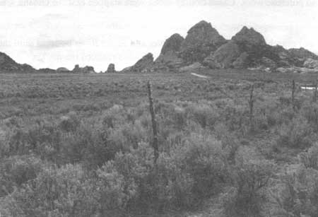
|
| Figure 17. Juniper-post, barbed-wire fence at City of Rocks National Reserve (HRA 1995). |
By mid-June, the first garden plot could safely be planted; that of Frederick Ottley was "fenced" in dry sage. All required artificial irrigation, most often supplied from the developed springs that also provided domestic water.
Winter sustenance for themselves and their stock thus tenuously assured, residents ventured to the timbered reaches of the Albion Mountains, along the north and east slopes of the narrow valleys draining Mount Independence and Graham Peak. Here they harvested full logs of white and yellow pine, for use in construction of homes and outbuildings. Aspen poles and contorted juniper logs served as fence posts and supports for the dirt roofs that most often covered pioneers' first homes. (The "road to timber" noted by GLO surveyors in the late 1880s remains visible through the City of Rocks. Those who arrived in the 1870s remembered that "there was no road into the hills at all, they had to drag their timber out to make their buildings and fences.") [228]
|
Proving Up "Saturday, May 20, 1882: piled and burned sagebrush [Diary of Frederick Hugh Ottley,
1880-1952.]
In the spring of 1882, 17 year old Frederick Ottley and his older brothers Henry and Hans trailed stock from Union, Utah to the Goose Creek settlements of Oakley and Basin. Here, Hans and Henry searched for a homestead, abandoning two before filing claim to land along Cassia Creek, just north of the City of Rocks. Between May and the first heavy snow of October 1, Frederick grubbed sagebrush; dug a ditch; planted potatoes, oats, and a garden (fenced in the ubiquitous sage); chinked the log cabin with willow; constructed a chicken coop (plastered), a pig pen, a stockyard; hauled hay; and went fishing when he could. After spending October with the threshing crew "at the Barkers," Frederick returned to Union where he remained for the next three years. Back on the claim in May of 1885, Frederick "helped Henry get some poles from Stinson Canyon and put up some fence"; "worked at making a water ditch in Green Canyon"; and "snaked a log out of Pine hollow for a pig trough." October 21-24, after five weeks of traveling with the threshing machine, Frederick "chopped 32 house logs," suggesting expansion of the original dirt-roofed cabin. In 1889, Frederick purchased the "Samuel Woods place at Elba." The daily litany of tasks ceases, replaced by a yearly summary of the year's precipitation and harvest: 1894: Water was plentiful — raised 690 bushels of grain and 44 bushels of timothy seed. 1895: This was a very dry year, very little snow in the mountains, and scarcely any rain in Spring or Summer. I raised 305 bushels of grain [less than half of the preceding year]. 1896: Last winter was quite light in regard to the fall of snow, but after the crops were in very heavy rains came, I received some damage through the creek overflowing and washing through the grain patches. Ottley survived the dry years and the floods. He died in 1952, a successful farmer in a community that he had pioneered 70 years earlier. [Diary of Frederick Hugh Ottley,
1880-1952.]
|
Long-time resident Etta Taylor described homes as generally consisting of only one room, "close built, daubed up with mud or clay, . . . [with] few windows ... and usually but one door." [229] John Lind's first cabin in Junction Valley was built of dovetailed hewn logs, chinked with clay and grass mortar. Small poles "fitted close together on top of heavy logs, and the tall grass and fine grasses to keep the dirt from falling through, completed a good dirt roof." [230]
The first windows of oiled paper were replaced with glass "when the first trip was made to Utah." The Thomas King family carefully fattened a litter of pigs all summer, loaded them in the wagon in the fall and proceeded south along the Kelton Stage Road to Salt Lake City. Here they attended the semi-annual gathering of the Mormon faithful, traded the pigs for window glass, and returned home. [231]
As the size of the community increased, neighbors would hold "house-raisings," and a home could be constructed in a matter of days. [232] Skilled carpenters were rare, occasionally called on for the more technical tasks of setting windows and doors "but outside of that, we built the rest of the house of our own initiative and know how. We built our barns and corrals. There wasn't much." [233]
|
[Log hewing] was a tedious, back breaking tiresome job especially the hewing, standing straddle of the log, bent over the broad axe in your hands hewing to a chalk line the entire length of the log. [John Lind, "History of John, Emma,
and Alex Lind's Settlement south of Almo," p. 37.]
|
The seasonal habitation practiced by many of the area's dryland farmers affected the built environment. In striking contrast to the tight-fitted, closely daubed winter residences described by Lind and Taylor, the seasonal home of Mrs. Angie Holley (widow of original claimant John Holley) was a
small 14' x 18' rough hewed log cabin of one room with windows east and west and door to the east. The roof is of lumber, covered with dirt. The floor is laid with dressed 12 inch boards with some wide cracks between boards which permit drafts from the exterior. The base of the cabin, which is built upon logs set as posts in the ground, is not sealed with dirt or by other means." [234]
The "single boarded, 2 room, 14' x 22' box" inhabited by Thomas Fairchild, his wife, and their seven children was similarly unsuitable for winter use. [235]
A few of the dryland farmers did attempt to stay year-round on their upland claims. Walter Mooso spent three winters at his homestead at the southern base of the Twin Sisters. He lived in a "two-story," log house with a little room upstairs. This log dwelling replaced his first 10 x 12' board shack that had a [box] "car" roof.
|
Fencing was a slow process. "One post had to have four holes, bored with one and a quarter inch auger. The pine or aspen had to have one hole bored in its big end. Two posts were set in each post hole . . . Posts were set one rod apart. A wooden peg was driven through the holes." [Lind, "History of John, Emma, and
Alex Lind's Settlement south of Almo," p. 63.]
|
Within the larger City of Rocks region, a progression of housing styles evidenced economic stability and Mormon adherence to Brigham Young's directive to build with brick and stone in symbolic testimony to the Saints' difference from and resilience to, the Gentile community. In Almo, brick and stone replaced the log and frame buildings initially constructed by area settlers. In many cases locally manufactured brick was simply applied as a veneer to the log and frame buildings — thus achieving the desired appearance without incurring the expense of constructing a new building. Within the reserve, only the Tracys' Circle Creek Ranch achieved this level of stability with the completion of their stone ranch house. [236]
Interior furnishings were similarly sparse. In 1888, City of Rocks resident George Lunsford furnished his 16' x 18' log house with "1 stove, two beds, 1 table and culinary utensils, [and a] sewing machine." In the "very early days" prior to the 1883 arrival of the Oregon Short Line to Burley, residents constructed their own "crude" furniture; freight charges for furniture were high, and rocking chairs and bureaus "were almost forbidden luxuries." "Pewter and tin dishes" furnished the tables. In the absence of electricity (brought to the Raft River Valley in 1940), residents relied upon oil lamps, pitcher pumps, coal or wood stoves, and ice boxes. Those without ice boxes hung perishables on long ridge poles running along the north side of the house. [237]
|
Dad and Uncle Jim decided to make bricks for their new homes [ca. 1910]. In the Amminden field on the side hill was the site. They made the bricks out of mud, clay and straw. They had to have lots of water so they dug a well in the wash at the bottom of the side hill. It was Fred's and my job to turn the bricks every day. It seemed like there was a whole acre of them. [Life Story of Bertha T. Kimber, n.d,
City of Rocks National Reserve.]
|
Patent files for claims within the boundaries of the City of Rocks National Reserve are primarily for small-scale dryland claims and reveal a remarkable similarity in agricultural infrastructure. Residents consistently constructed hen houses/chicken coops, pig pens, "carrels (corrals [?])," "hay carrels," miscellaneous sheds, cellars, developed springs, miles of fencing, and an occasional barn. The more prosperous irrigated and stock claims of George David, Mary Ann and William Tracy, George Lunsford (sold to William Tracy), Margaret and John Hansen, and Eugene Durfee also boasted stables, granaries, hay yards, and stockyards (see Appendix A). Like the homes, ranch infrastructure evolved as money, time, and manpower were made available: John Lind constructed his barn in 1894, ten years after initial settlement. A rock floor and piped water "came a little later." [238]
Rough-milled lumber needed for residential and agricultural development was supplied locally. As early as 1890 saw mills operated at various times on Howell Creek, Howell Canyon (later moved to Bennett Spring), Stines Canyon, Almo Canyon, Mill Creek, Cassia Creek, Pole Canyon, Rock Creek, Johnson Creek, and George Creek. These mills provided roughsawn lumber for siding and door and window frames, poles for fences, and shingles for roofs. All Minidoka timber products were "used locally for the development and maintenance of agriculture"; the vast majority of the 2,000 special-use permits issued on the Minidoka National Forest in 1917 — "the height of the dryfarm era" — were for small-scale timber harvests of posts and poles. Similarly, at least two brickyards existed in the vicinity of Almo, producing brick from local clay. [239]
Irrigation Systems
The Desert Land Act testimonies of Mary Ann Tracy (who owned Circle Creek Ranch with her husband William), of Margaret Hansen (whose land adjoined the holdings of her husband John Hansen), and of Joseph Moon provide limited descriptions of irrigation networks constructed within the boundaries of the City of Rocks National Reserve. The Circle Creek Ranch main ditches, drawing from reservoirs on Dry Canyon, North Circle, and South Circle creeks, averaged 1 foot deep and 1.5 feet wide. (The dimensions for two "smaller" lateral ditches are not provided.) (Figure 18).
|
| Figure 18. Ditch network associated with Circle Creek Ranch, Circle Creek Basin, City of Rocks, 1903 (Mary Mary Ann Tracy, "Final Proof," Desert Land Entry #567, National Archives, Suitland, Maryland). |
In 1909, Margaret Hansen proposed to construct a reservoir on the South Fork of Circle Creek, "300 feet long, 10 feet high, and backing water up about 150 feet." Main ditches from this water source were to be 1.5 feet deep and 2.5 feet wide, with a capacity of "about 200 inches." No evidence of either the reservoir or the ditches was found in the field, suggesting that the system was never constructed.
In 1925, Joseph Moon patented land encircling the Emigrant Canyon spring and containing the abandoned City of Rocks stagecoach station; his requisite irrigation network consisted of a stone dam below the spring, and a "trench" running from the reservoir out of a steep gully to a main ditch and two laterals.
Most often, limited irrigation water within the City of Rocks was drawn from the developed springs that also provided domestic water. At the Samuel and Emma Mikesell homestead, for example, a windmill powered the pump that fed not only the large garden, but the trees and roses that shaded the porch of the sheepherder wagon that had been converted to their home. [240]
The Transportation Network
The transportation network also reflected the evolving economic orientation of the area. Prior to passage of the Enlarged Homestead Act, roads within the City of Rocks generally followed the historic alignments of the overland trails and the various routes of the Kelton Road. Insubstantial secondary routes led "to timber" or served as cattle and sheep trails. [241]
E.B. Dayley, who pioneered the Basin community, near the northwest corner of the City of Rocks National Reserve, informed forest ranger C.E. Jensen that, in 1881,
there were no roads at all, his job was to get ahead of the expedition with shovel and pick and locate crossings and start work on them until the rest caught up, then they would finish and he [would] proceed on ahead. . . . In this way the first routes of travel [to Albion and Rock Creek] were established.... Before that they had to go to Utah to get flour and the necessities they could not make." [242]
The condition of the California Trail between Almo and Junction Valley was so poor in the 1880s that custom threshing crews from Almo were unable to travel to John Lind's Junction Valley homestead. Improvements to this first road network were made by community road associations. In Almo, ca. 1880, "each man in the community was assessed three dollars, to be paid in cash or labor." [243]
With the ca. 1910 settlement of Junction Valley and of the City of Rocks, these routes were improved, fenced, and reconstructed to follow section/claim lines. The intensive operation of Utah's Vipont Mine, 1918 to 1922, also resulted in significant improvements to the Birch Creek road, the primary haul road for Vipont ore. [244] By 1920, the regional road network had achieved roughly its current configuration:
Oakley is joined to Burley . . . by a graded and graveled highway. From Oakley a secondary road in fair condition leads southeastward across the Cassia City of Rocks. Another road extends directly east and across the Albion Range and descends to Elba.... From Albion a secondary road passes southward through Elba and Almo to the Cassia City of Rocks . . . . The basins and foothills of the ranges are nearly everywhere accessible, mostly on roads which are not maintained and seldom used except by sheep wagons. [245]
These were the days of the "9-foot standards" when the grades necessitated "supplemental pushing or leaving the car at the bottom of the hill." [246] Not surprisingly, much of this road system was unusable during the winter months, including the road "across the Albion Range," and the Emery Canyon road connecting Oakley with the City of Rocks; Oakley residents were thus effectively isolated from the Raft River Valley for much of the year and those who resided on the "easterly side" of Goose Creek "transact[ed] all or the greater part of their business" in those communities east of the City of Rocks, primarily Burley and Albion, but including Almo, Elba, and Malta. (This reliance upon local trading centers was historically blunted, in part, by Mormon residents' semi-annual pilgrimages to Salt Lake City, in April and November, for the meetings of the faithful. Here they made their major purchases, and reinforced southern Idaho's cultural, religious, and economic ties to Utah. In modern times, the reliance upon local merchants for even day-to-day necessities and incidental purchases was lessened by "extensive use of the automobile" and improvements in the county road system, both of which facilitated buying trips to Burley, Twin Falls, and Boise.) [247]
Local residents, through the road associations, maintained as well as constructed these gravel roads. In the 1930s, the Civilian Conservation Corps also assumed responsibility for the construction and reconstruction of approximately 50 miles of road within the boundaries of the Minidoka National Forest, including the Birch Creek road to the City of Rocks. Despite these improvements, as late as the 1950s, residents put their cars away in November, choosing the more "sure" conveyance of team and sleigh. [248]
Growth of a Stable Community
The common bond? They were all church members and they were all poor. [249]
Originally part of the Oakley Ward of the Church of Jesus Christ of Latter-day Saints (LDS), by 1887 the Albion, Elba, and Almo communities supported a sufficient Mormon population to be established as independent wards within the Box Elder Stake. [250] By 1890, 40 of the 55 families in the Almo vicinity belonged to the Mormon Church. From this nucleus of LDS members grew a stable, homogeneous community, led by Raft River pioneers and Mormon elders Thomas King, Myron B. Durfee, Henry R. Cahoon, Charles Ward, James Lewis, and others. [251]
The religious homogeneity reported by the church chronicler is supported in census records: the 1880 tally of the Almo enumeration district [252] shows concentrated settlement of Scandinavian and English immigrants, most recently from Utah. This settlement accords with larger Mormon demographic trends. In 1850, the vast majority of converts to the Mormon faith were from the American Midwest and Northeast. By 1880, fully half of those Mormons not born in Utah listed Scandinavia or the British Isles/Canada as their place of birth. These later emigrants initiated a dispersal from the core Mormon communities along the Wasatch Front to a Mormon domain that ultimately encompassed all of Utah and much of northern Arizona and southern Idaho. [253]
In Almo, Elba, and Albion in 1880, the numerous children were "at school," the women "at home," and the men most often identified themselves as stockmen, farmers, or (curiously) as emigrants. The agricultural orientation was to be expected; the formal occupation of "emigrant" may suggest nothing more than residents' recent arrival or may underscore their assumed responsibility to expand the range of Mormon influence.
|
The people had always provided a good time for themselves... Square dances, quadrilles, polkas, Virginia Reel two steps and waltzes were enjoyed... People came from all the surrounding communities to enjoy the fun. Young and old were included. The babies would be put to sleep on the benches while the oldsters danced far into the night.... Relief Society 17th of March socials were also great events. This was an all day celebration... The school was dismissed about 2:00 or 2:30 and the children came for their feast. Then they had a children's dance. Those were never to be forgotten good times. [Elbert Durfee, "Remembrances of Almo
Community," n.p., n.d., on file at City of Rocks National
Reserve.]
|
Albion, Almo, Elba, and Moulton (Junction Valley) census enumerations for 1900, 1910, and 1920 show little change in the pattern established in 1880. Utah and Idaho continued as the dominant birthplace of parents and grandparents, with ethnic ties linked most closely to England and Scandinavia. Farming and ranching remained the dominant economic activities, and the birthrate remained high. By 1920, the vast majority of minors listed Idaho as their place of birth, indicating that a stable community with few transient members had been established. Local tradition verifies the census: "pretty much they married their own folk here. . . . Course some of them married away and left but not too many." [254]
By the turn of the century, Almo boasted a school, a post office (with mail every Thursday), and a store. Charles Heath and John Eames had formed a drama company and brass band (both of which traveled to surrounding towns). A Stake Welfare Farm met the needs of the newly arrived, the temporarily impoverished, and the widowed and orphaned. The three saloons "and other undesirable" remnants of the free-range cattle era had been "controlled" through creation of the Village Control Organization, composed entirely of church leaders. The Almo Water Company, established in 1889, controlled the domestic and irrigation water supply from Almo Creek: "each man who wanted water bought shares in the Company and was given water accordingly." [255]
In 1920, the town supported 260 "souls," the majority of whom were described as farmers and stock raisers. The town contained "the finest meeting house in the Raft River Stake" (a brick replacement of the log meeting house constructed in 1880), a modern schoolhouse, Tracy and Eames General Mercantile, a hotel, a barber shop, "a small road-side inn," and a number of "fine brick residences." [256]
This was a Mormon town, platted on 40 acres of Myron B. Durfee's homestead, centered around the school and the ward house, showing a strong reliance upon brick construction (distinctive from the Gentiles and symbol of Mormons' resolve to stay and to prosper), and upon community organizations. Church records and patent files for those who homesteaded adjacent land within the City of Rocks suggest that the town was also designed around the Mormon principles of communal settlement: Mormons throughout the West consistently established primary homes in community centers, using adjacent land for cultivation but not for habitation. Wallace Stegner writes in Mormon Country that
The Mormon village is like a medieval village, a collection of farm houses in the midst of the cultivable land. It is a symbol of the group consciousness and the group planning that enabled the Saints to settle and break a country so barren. . . . In the period of settlement, and to a large extent still [1942], farmers did not live on their land.... The medieval town surrounded by its fields was a practical and sound pattern of settlement. A man could not by himself build and keep in repair a dam, miles of ditch, and all the laborious extras of irrigation farming. This was a country that could be broken only by the united efforts of all. [257]
Patent files and oral histories clearly establish that City of Rocks residents left their claims during the winter months to escape the snow and to secure schooling and wage labor. This pattern also held, at least through the 1910s, for inhabitants of Almo and Elba — "many" of whom moved to Burley and Albion for the winter "to take advantage of the social, and educational facilities at these places." When the family stayed behind, those teenage children attending high school often boarded in Burley or Oakley. [258] Yet City of Rocks residents may also have resided outside what is now the reserve during the summer months, traveling daily to the rough cabins to work their fields and tend their stock, and returning to more permanent homes within the confines of their Mormon village. This settlement pattern differed significantly from that of the Gentile community, was at odds with the requirements of homestead legislation, and would have had a marked impact on the built environment. GLO agents reported that Stella Holley's homestead cabin was essentially uninhabitable and that she appeared to live "in town," traveling to her claim during the summer months to tend to her three-acre garden and to her limited stock. Local residents indicate that Eugene Durfee's claim within the reserve was used for summer pasture for his milk cows and that only the children lived there, while their parents remained at the family home in Almo, traveling to the claim only as needed. This pattern of habitation assured that the Mormon village "formed a center," and a stage for cooperative land use and social and religious interaction.
In contrast to Almo and the northern City of Rocks claims, church historian Andrew Jensen described the southern City of Rocks and Junction Valley communities (within the Moulton Ward) as lacking a village "to form a center. . . . All the inhabitants live in a scattered condition on their respective farms." [259]
"At Home"
From 1880 to 1910, census takers correctly defined women in the vicinity of City of Rocks as employed "at home." Not until 1920 is their official occupation denigrated to "none", an astonishing title for women charged with being "self-sustaining in all . . . things . . . in our entertainment, in our food processing, in our sewing." [260] Annie Durfee Cahoon moved to Almo as a bride in 1879 and had seven children by 1894. Her tasks included
washing on the board, ironing with irons heated on the wood stove, making soap, killing and taking care of all their own meat, the vegetable garden and the fruit trees, packing water and heating it on the stove — no electricity — besides cooking and cleaning and sewing and the other things mother has to do to look after a little family. [261]
|
I graduated from the 8th grade in the new [Almo primary] school... I took the eighth grade twice because I didn't want to stay home. The folks did not want to let me go away from home and there was no high school in Almo. . . [In 1918] I coaxed [Dad] to let me go to high school at Oakley. He wasn't thrilled about it but he did let me go. Grace Thompson and I rented a room and batched together. We paid $4 a month rent. [Life Story of Bertha T. Kimber,
n.d., City of Rocks National Reserve.]
|
Rhea Toyn of neighboring Grouse Creek remembers weaving carpets to cover the floors, making candles, mending shoes, and tanning leather. Women also served as midwives and nurses in a place where childbirth and disease were frequent, doctors scarce, medicine primitive, and roads slow. [262]
Minors were also at home. Census records for Almo, Elba, Albion, and Moulton (1900, 1910) consistently identify sons, over the age of 12, as "farm laborers" rather than as students; daughters' schooling was similarly brief. By 1920, the census reveal that children stayed in school until the age of 16 or 17; these schools, however, closed for up to two weeks so that children could help with the harvest. [263] Clifton Rooker, born in Albion in 1906, remembered that "money [was] always a problem [and] it was natural and necessary that everyone had to work as soon as they were able and could find a job that would make money." Clifton and his brother Harold gathered wool tufts left by bands of sheep as they were trailed under fences: "Some years we would gather impressive amounts which was [sic] then sold to a man with wool to market." In a process repeated by Plains children throughout the West, Clifton and Harold also gathered the tails of the ground squirrels that destroyed area crops. Once trapped, the tails were cured on area fences, and redeemed by the county at "some fraction of a cent." The summer of 1921, when Clifton was 13, he took a job on a neighboring farm. Here, for $1 per day plus room and board, he milked the six or seven cows; fed the hogs, cows, horses, and chickens; cleaned the barn and stables; hoed and thinned the beets; irrigated the various crops; and moved and raked the hay. [264]
The economic contribution of women and children to their homes and communities was strengthened by the dearth of cash within the local economy: "we hardly knew what a dollar was, really." [265] The products of their labor — eggs, butter, cheese, handiworks, soap, candles — and the crops that they helped to harvest, sustained the family.
A Barter Economy
From 1881 until the last year of record in 1904, members of the Elba Ward proffered butter, cheese, wheat, hay, script, oats, potatoes, bacon, and dimensional lumber to the church as their annual "fast offerings." Although cash tithes increased over the years, they remained a significant minority of all contributions. [266] Children eagerly entered the general mercantile clutching surplus eggs rather than pennies, trading them for "a bit of candy." [267] Adults traded potatoes or grain at the same mercantile, for those staples they could not grow themselves. Sheepmen, "passing through," carrying cash, and in need of both potatoes and flour, provided the merchant with the requisite legal tender. [268]
The barter system broke down at tax time, in years of poor harvest, and when making large purchases of equipment, stock, or land. Men then left their ranches and their homes in search of markets for their products or in search of wage employment. [269]
Moonlighting
|
I started to milk cows when I was five years old. I could churn the butter but Dad washed and molded it, wrapped the pounds of butter in a heavy wax paper... The butter was sold to the Tracy Store or sometimes we took it to a store in Elba; about twice a week Dad sold milk to Mr. Lowe from Grape Creek, who came in has wagon to pick up the milk for his cheese factory... We would rush to open the gates for Mr. Lowe. He always gave us a nickel each to open gates... That was the only money we ever had with the exceptions of on the 4th and 24th [Pioneer Day] when we were given .25 cents to spend. We did not feel bad about not having money. We were just thrilled when we did get some... After Margery was born [1912] Dad said, "Bertha is not going to milk any more cows. She is staying in to help her mother." . . . I never had to go to the corral again. I'd much rather help mother in the house. . . . On ironing days and wash days I had to do my share. I'd rather do most anything than milk those cows. [Life Story of Bertha T. Kimber,
n.d., City of Rocks National Reserve.]
|
With the exception of the few and requisite storekeepers, butchers, and blacksmiths who inhabited Raft River and Goose Creek communities, the vast majority of men (and widowed women) identified themselves as ranchers or farmers — a response not only to the available resources but also to the Mormon philosophy that "a poor man's best mine is in a potato patch." [270] However, this agricultural emphasis disguises the extent to which City of Rocks residents "worked what work [they] could." [271]
Men appear to have relied most consistently on mining and on freighting as a source of wage labor. In 1848, a Mormon battalion returning to Salt Lake City from the Mexican War, discovered mica (often an indicator of more valuable gold deposits) along the banks of Goose Creek; subsequent travelers prospected the area but no major strikes were made. Circa 1889, the Vipont brothers located the Vipont silver mine in northern Utah. The mine produced sporadically, under eastern capital, from 1890 until 1923, with a maximum employment of 250 men (1918-1923). During this time the mine "supplied labor for those [Junction Valley residents] who needed work and a market for much of the produce raised." [272]
Mines within the more immediate project area were limited in number and in quality. The Melcher Mine near Elba and the Badger, Alice, Cummorah, and Jennie mines within Connor Canyon and Connor Flat (north of the City of Rocks) suffered from both insufficient ore and a poor transportation network and were thus not significant sources of employment or of revenue. [273]
Mica and silica outcroppings scattered across the City of Rocks attracted only sporadic interest, most notably during World War II, when the federal government subsidized mica production in an effort to meet its wartime supply needs. Despite prospecting within the City of Rocks, there is no evidence that "strategic mica" — hard, clear, flat, and free of mineral inclusions and cracks was found in sufficient quantity to attract outside investment or to warrant substantial excavation. In 1950, only Latah, Adams, and Idaho counties boasted profitable or active mica mines. "Attempts were made to work prospects in other parts of Idaho but met with failure." [274]
Freighting also provided cash. After delivery of produce to market, residents would freight a return load in their otherwise-empty wagons. [275] Clifton Rooker remembered that his family's 40-acre ranch near Albion
never quite produced enough to meet the family needs. As a result, Father usually had to obtain other work to supplement the meager income which came in from the few milk cows that we had. He engaged in freight hauling for a number of years, hauling freight from Declo, the nearest rail point, to the Melcher Mine. [276]
Between June and September of 1889 and 1890 (in the narrow gap between planting and harvest), Frederick Ottley worked for Ed Conant, driving the stage between Kelton and Albion [277]
Men also hired on for construction of the Oakley Dam, a Bureau of Reclamation/Carey Act project (1909-1911) or the Bureau of Reclamation's Minidoka Project at Rupert, working construction, or as "ditch riders." Others took jobs in the sugar-beet factories, or traveled from ranch to ranch, shearing sheep, threshing grain, or putting up hay. Walter Mooso and Lee Nelson ran a winter trap line "in and around the City of Rocks," making a "fair living" selling lynx, bobcat, coyote, wolf, and badger hides. Indeed, Mooso stated that he could make more money in six days of trapping than in an entire summer of dryland farming; his son verified: "if it wasn't for his trapping he would have had one tough time making it." [278] Bertha Taylor Kimber also remembered that her father and Billy Cahoon "trapped animals in the winter to add to the family funds. They trapped many coyotes, muskrats, badgers, skunks, mountain lions and weasels." Others sold deer hides to the Fort Hall Indians who used the leather to make beaded buckskin gloves; Ida Bruesch recalled that "the people depended on that for a good deal of their living." [279]
Rhea Paskett Toyn does not know how she and her husband Archie made ends meet, only that they did "somehow." Others were less successful. As the drought hit in 1920, Cheney Vao Leroy's parents "lost or somehow were unable to keep" their Albion farm and moved to California. [280] In recommending final approval of Thomas Fairchild's marginal claim, forest ranger T. C. Clabby noted, "[The claimant] had no means to work with when he took up the claim and it is plain to see he has not accumulated anything since." [281] When the two-room log house of City of Rocks rancher Merritt A. Osterhout, his wife, and three children, burned in September of 1915, Osterhout
did not have the means to rebuild, and left for the winter, going to Burley Flat, where he expected to be able to earn sufficient [wages] to enable him to rebuild the following spring, but found himself unable to do so, and as his crop of 1915 amounted to only 260 bushels, it was insufficient for the support of himself and family, and made it imperative for him to be absent to earn a living elsewhere and impossible to go back to the land in the spring of 1916. [282]
Assured of Osterhout's "good intentions," the General Land Office granted title to the land in January of 1918. Less than ten years later the land was abandoned. [283]
|
Most of the people still living here were not too much effected by the depression at first, for they had been pretty much self-sustaining. They produced much of their own food and fashioned their clothing themselves. A yearly trip to Ogden for fruit to preserve and needed material not produced here was all they were used to. However when drought struck it was a hardship. [Elbert Durfee, "Remembrances of Almo
Community," n.p., n.d., on file at City of Rocks National
Reserve].
|
For western farmers, the Great Depression of 1929 had begun a decade earlier, with the end of World War I, the end of inflated wheat prices, and the end of above-average rainfall. In 1925, instead of collecting grazing fees in advance, Minidoka rangers "took the stockman's [promissory] notes." [284] During the 1930s, the volume of timber taken from the Minidoka National Forest under free-use permit almost doubled, "due very likely to economic conditions causing many families to use wood for fuel in place of coal." [285]
Almo's population dropped from 260 in 1920 to 245 in 1930; this drop was particularly significant given the high birthrate within the Mormon community. [286] The Moulton Ward, encompassing Junction Valley and much of the City of Rocks, fell from approximately 100 inhabitants in 1920 to 64 in 1930. These numbers continued to decline over the next four decades as range rights and homestead options became more limited for the children of the founding families:
There's no way to provide for these boys. . . . They can't go into the stock business in this country. There's no ground for sale. Everything seems to be tied up . . . Generally a man, most of them had big families. One boy probably could have took over, but what about the rest? [287]
Elba resident Charles Twitchell echoes: "There were six of us boys. Some of us had to move on." [288]
Conservation and Recreation
Another resource not yet utilized is the scenic attraction of the "Cassia City of Rocks." This unique area is surely worthy of development and deserves recognition as a National Monument. [289]
For Charles Brown, publisher of the Oakley Herald and president of the Oakley Chamber of Commerce, economic recovery (if not salvation) lay in creation of a National Monument at City of Rocks and in harvest of the area's tourist potential. Recreational use of the area was not new: since settlement, the region had served "as a favorite picnic spot of southern Idaho residents" and a frequent "field-trip" destination for area school children. [290]
Yet there was little economic benefit in local use and in 1926 Brown initiated a concerted publicity campaign aimed at gaining the attention of the traveling public, of local congressional leaders, and of those who controlled the county's road maintenance and construction coffers. Brown was joined in his efforts by geologist Alfred L. Anderson, who frequently worked for the Idaho Bureau of Mines and Geology, by state politician Byron Defenbach who prepared an Idaho Trails and Landmarks Association plan, and by Idaho Senator James P. Pope, who presented Defenbach's plan to Franklin D. Roosevelt and the New Deal congress.
Their publicity campaign included frequent editorials; pictorials; pages of testimonial from geologists, historians, and local and regional dignitaries; bathing beauty contests held at Bathtub Rock; and annual prizes to the best paper presenting a topic of local history. (The 1938 winner "recreated" a version of the Battle of Almo Creek in gruesome detail.) [291]
Aesthetically, Brown and others compared the City of Rocks to Utah's Zion Canyon and Colorado's Garden of the Gods. Geologically, Anderson offered oft-repeated testimonial to the uniqueness of "such a complete assemblage of bizarre and fantastic forms within an area of two or three square miles." Historically, the City was lauded as being "rich in the history and legend of the Old West," a place of Indian Massacre and Stagecoach Holdup. [292]
By 1938, Brown's proposal to create a National Monument at City of Rocks had been "indorsed by every member of Idaho's congressional delegation; by Governor Clark; by the Oakley and Twin Fails chambers of commerce; by such influential daily newspapers as the Twin Falls News, the Idaho Evening Times, the Boise Statesman, and the Salt Lake Tribune; by many of the weekly papers published in the West; and by organizations and individuals and publications throughout America" (many of whom were members of Brown's "Advisory Council Advocating [a] National Monument at City of Rocks"). In October of 1938, Brown organized a tour of the City; participating dignitaries included Clark, Pope, Anderson, future U.S. Senator Henry Dworshak of Burley, E.C. Munson (Union Pacific assistant general manager), and Edmund B. Rogers of Yellowstone National Park. Although thwarted by a severe snowstorm that precluded travel from Oakley to the City of Rocks, Senator Pope arranged for a full National Park Service investigation of a potential National Monument at City of Rocks. Historian Merle Wells reports that "Nothing like this had been attempted in Idaho before, and it would be difficult to identify any such project to match it anywhere else." [293]
The irony of the region's important role as a crossroads of overland and stage travel can not have been lost on these local boosters. Monument status and economic benefit were most severely challenged by the lack of a modern transportation system:
The area has great possibilities from a tourist standpoint, but people should not be inveigled into the section until roads are improved. For the hardy Idaho roamer the matter of a few miles of bad road should not play any important part, but if we want outsiders to visit the section, immediate steps should be taken to secure the construction of good roads . . . .
By 1938, CCC crews, under USFS supervision, had reconstructed the Emery Canyon Road connecting Oakley with the City of Rocks, and had oiled and improved the Elba to Oakley road past Mount Independence and Independence Lakes (just north of the City of Rocks). The county followed suit, oiling the public highways connecting Burley with Oakley and with Almo. By the late 1930s, forest service officials reported a "striking increase" in recreational travel to Independence Lakes and the City of Rocks, augmented by the "increased use of automobiles and the construction of several access roads."
The push for monument status stalled following America's entrance into World War II (when military needs diverted attention from local conservation concerns and fuel restriction terminated the annual tour program) and ground to a virtual halt following Brown's untimely death circa 1945 and the subsequent closure of the Herald. Long-time Basin resident Newell Dayley and Cassia County Historical Society president A. W. Dawson revitalized the movement in the late 1950s by reintroducing the dramatic pageants, and publicity tours. By the 1960s, the Idaho Historical Society led a series of well-attended field trips through the City of Rocks, and the National Park Service prepared a sequence of design proposals that suggested possible protection and development strategies. [294]
In 1957, the state of Idaho classified a (state-owned) endowment or "school" section in the center of the City of Rocks as a state park. In 1964, the City of Rocks was established as a National Historic Landmark, for its association with overland migration. Ten years later, the area was designated a National Natural Landmark, in recognition of its geological and scenic value.
Proposals advocating federal ownership or control of the region, however, encountered substantial resistance from local land owners. After much local debate, initial proposals for a 30,000- to 35,000-acre unit under federal control (and possibly designated as a National Park or Monument) were rejected in favor of a 13,000 acre reserve, to be managed by an inter-governmental program composed of state and federal officials.
Congress created the City of Rocks National Reserve in 1988 in order to "preserve and protect the significant historical and cultural resources; to manage recreational use; to protect and maintain scenic quality; and to interpret the nationally significant values of the reserve." Tourism (and the attendant infrastructure of campgrounds, trails, and parking areas) has increased dramatically since that time, inspired not only by the beauty and history of the place but also by the recreational opportunities offered by the rocks themselves. [295]
The first climbers' guide to the City of Rocks, published in 1989, described a variety of free climb and bolted routes in six general geographic areas: the "upper city" (near Emery Canyon), the "parking lot" (along the road to Emery Canyon/Oakley), the "inner city" (Circle Creek), the "lower east side" (surrounding Echo Gap), "center city" (within the dryland homestead basin), and the "Twin Sisters" vicinity. Local climbers soon kept company with climbers from around the world, vying for position on Elephant Rock, Bath Rock, the Twin Sisters, and other monoliths renamed by the climbers — and competing with stockmen, private land owners, and tourists for use of the land and of camping spaces. [296]
The introduction to the second edition of the City of Rocks, Idaho. A Climber's Guide (1995) includes a terse description of the "worsening private land problem," the increased conflict with a "small but fanatic group of anti-bolt activists," and National Park Service "bureaucrats' ... efforts to replace the qualities most City of Rocks visitors cherish with a 'historic theme park' approach geared toward motorized RV traffic." CLOSED notations checker this second guide, slashed across the Twin Sisters, Kaiser's Helmet, Camp Rock and City Limit, Register Rock, and the south wall of Elephant Rock. In defense, and in fear that the city will be closed to all climbers, author Dave Bingham urges his readers to "keep a low profile," avoid all emigrant inscriptions, stay on the trails, use the garbage cans, close the gates, and give "the City of Rocks the care this special place deserves." [297]
Conclusion
Awareness that this is a special place is the constant thread running through the history of the City of Rocks, from the time of American Indian use and habitation to the current debate raging about how best to perpetuate, enjoy, and honor the area's scenic, geological, and historical resources.
Beyond this overriding constant are rich ironies that effectively illustrate westerners' changing demands on land and water resources. The City of Rocks was once at the crossroads of transcontinental travel. It is now on one of the back roads of America, accessed only by those who seek it, who leave the interstate highway system, and travel along ever-narrowing roads, through ever shrinking communities.
The historically significant and much-revered axel grease graffiti of those emigrants who advertized "I was here" — in Oregon Territory, at the border of Mexico, three months from home and two months from safety is joined by the less significant and often-impugned chalk stains and bolts of modern climbers. These more ephemeral stamps also advertise "I was here"; yet Here, now, means Up not West. And the Why of being Here relates to pleasure, to thrill, to recreation rather than to economic imperative and the search for livelihood. A similar shift in land values has occurred throughout much of the scenic West.
Despite over a century of land legislation, agricultural innovations, and reclamation projects designed to conquer and to green the semi-arid West, the City of Rocks accords with Fremont's 1843 assessment of land where grazing rather than farming "would claim a high place." What was adequate water for emigrants and their stock proved inadequate for farmers and their crops. What was a tolerable climate for those passing through, quickly, in August proved intolerable for those hit by the heavy frosts of September and the frequent snows of October.
Intensive cultivation of the lands adjacent to the Raft River and its tributaries, from the 1870s to the present, has dramatically altered the physical landscape. This land has been leveled and cleared of sagebrush. The willow that once lined the Raft River, providing sustenance for the beaver and shade for the emigrant wagons, has been cleared. The once-volatile Raft River no longer reaches the Snake, drained by extensive irrigation ditches and deep-well irrigation. To a large degree, fields of grain, alfalfa, potatoes, and beets have replaced the early surplus of sage and bunch grass. The City of Rocks stands in stark contrast to this modern landscape. Within the reserve, evidence of historic use and occupation is found in faint shadows rather than the harsh lines of ditch, field, and town: a worn inscription; hints of a wagon road; a crumbled foundation; indistinct changes in vegetation, indicating a former fence line and planted field.
| <<< Previous | <<< Contents >>> | Next >>> |
ciro/hrs/sec2.htm
Last Updated: 12-Jul-2004