|
Colorado National Monument Colorado |
|
 NPS photo | |
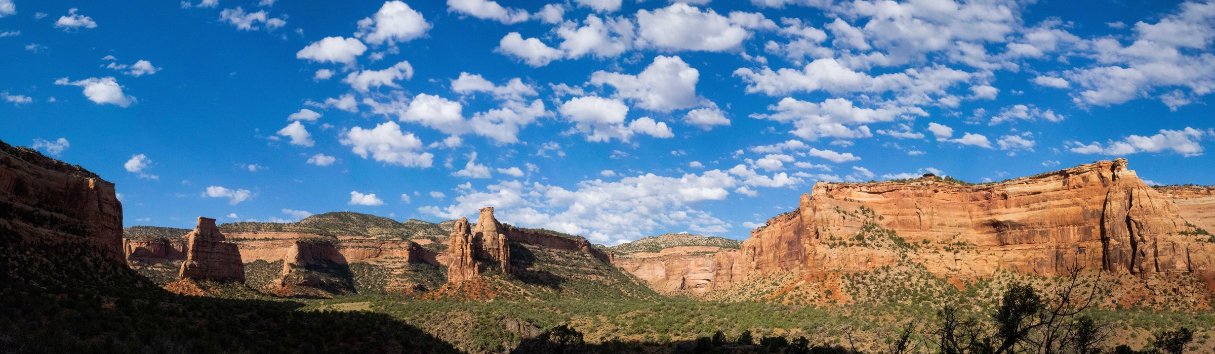
Colorado National Monument preserves one of the grand landscapes of the American West. Bold, big, and brilliantly colored, this plateau-and-canyon country, with its towering masses of naturally sculpted rock, embraces 32 square miles of rugged, up-and-down terrain. This is a special place, where you can contemplate glorious views that stretch to distant horizons; where you can discover solitude deep in a remote canyon; where you can delight in wild country where desert bighorns roam and golden eagles soar. In the spirit of John Otto and others with the foresight to create Colorado National Monument in 1911, and the many since who have sought to protect it, please treat the park with respect so we can share in its grandeur tomorrow.
The Uncompahgre Plateau rose high above its surrounding terrain millions of years ago during the gigantic upheaval that also created the Rocky Mountains.
Atop the Plateau
The Colorado National Monument highcountry rises over 2,000 feet above the Grand Valley of the Colorado River. Situated at the edge of the Uncompahgre Uplift, the park is part of the greater Colorado Plateau, which also embraces geologic wonders like the Grand Canyon, Bryce Canyon, and Arches national parks. lt is a semi-desert land of pinyon pines and Utah junipers, ravens and jays, desert bighorns and coyotes. Magnificent views from highland trails and the Rim Rock Drive stretch from the colorful sheer-walled canyons and fascinating rock sculptures to the distant Colorado River valley, purple-gray Book Cliffs, and huge flat-topped mountain called Grand Mesa.
The many sheer-walled canyons were carved primarily by the erosive force of floodwaters flowing over the plateau for millions of years. Recent rockfalls demonstrate that water; wind, and frost continue to cut the canyons wider and deeper today.
Backcountry Canyons
In the park's deep canyons, where vertical cliff walls and great natural rock sculptures tower overhead, the grand scale of the scenery is overpowering. Nowhere is this more true than in Monument and Wedding canyons, where the giant rock forms of Independence Monument, Pipe Organ, Kissing Couple, Sentinel Spire, and Praying Hands rise from the canyon floor !ike skyscrapers-in-stone.
But the canyons are places, too, where the cascading song of the canyon wren echoes, where smal!, life-sustaining pools linger after summer rains, where cottonwood trees turn golden in autumn. The canyons can be explored along backcountry trails. On a slow and quiet journey you might encounter mule deer, desert cottontails, antelope ground squirrels, rock squirrels, chipmunks, lizards, or canyon birds like pinyon jays, white-throated swifts, and rock wrens. Mountain lions, bobcats, midget faded rattlesnakes, and other rare or secretive members of the canyon community are seen less often. In spring and summer cacti, yucca, and other flowering plants bloom near springs, along seeps in rock walls, or near canyon pools and intermittent streams. These oases of water are lush compared to the sparse desert scrub life of pinyon pine, Utah juniper, sagebrush, mountain mahogany, and rabbitbrush that inhabits the more common arid portions of the canyons.
Masterpieces Erosion
From 45O-foot-high Independence Monument, the largest free-standing rock formation in the park, to the smallest detail carved in stone, the grand sculptor in Colorado National Monument has been erosion. Time—and lots of it!—has been a loyal ally, for it has taken millions of years to carve the many massive rock spires, huge domes, balanced rocks, arches, windows, stone pedestals, and sheer-walled canyons that make up the scenic splendor of the park. The erosive forces of water, wind, and ice work very slowly. Differences in the characteristics of the many layers of sandstone, shale, and other sedimentary rocks of the area help determine what form the rocks take. The harder rock layers are more resistant to erosion. One such layer—the Kayenta Formation—forms the protective caprock of Independence Monument and other bold, angular rock forms. Once it has been eroded away, rounded shapes like those of the Coke Ovens are formed from the less resistant underlying layers. Fractures in the rock also influence erosive forces. The remarkable colors—vivid reds, purples, oranges, and browns—are created by iron and other minerals in the rock.
The Creation of Independence Monument
Independence Monument was once part of a massive rock wall that separated Monument and Wedding canyons. Slowly, as the forces of erosion enlarged these canyons, the dividing wall was narrowed and weakened. Weathering and erosion proceeded more rapidly in places where the rock was most vulnerable along natural fractures. Eventually the wall was breached and parts of it collapsed. Today a remnant of the once solid rock wall survives as Independence Monument, a free-standing monolith. It too will eventually succumb to the ravages of time and weather.
One Man's Dream
"I came here last year and found these canyons, and they felt like the heart of the world to me," John Otto wrote in 1907. "I'm going to stay . . . and promote this place, because it should be a national park." Some folks thought John Otto was crazy. He lived alone out in the wild and desolate canyon country southwest of Grand Junction, and he loved the land so much that he campaigned tirelessly for it to be set aside as a national park. Urged by Otto, the citizens of Grand Junction deluged politicians in Washington, D.C., with letters and petitions in support of the proposal. Meanwhile, Otto built miles of tortuous trails through the proposed park area so others could appreciate its beauty. And he did it all without hope of any person gain. But in 1911 Otto's dream came true; Colorado National Monument was established. Otto was rewarded by being named the park's caretaker, a job he gladly did until 1927 for $1 a month.
Planning Your Visit
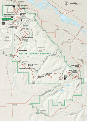  (click for larger maps) |
Visitor Center
The visitor center has information, exhibits, two audiovisual programs,
and a bookstore with maps and other publications. Staff is on hand to
answer questions and help you plan your visit. Schedules of guided walks
and talks are posted in summer. The visitor center is open every day
except December 25.
Rim Rock Drive
Rim Rock Drive offers 23 miles of breathtaking views. The road climbs
from the Grand Valley of the Colorado River to the park's highcountry,
then winds along the plateau rim. The drive is popular with bicyclists
as well as motorists. A Guide to Rim Rock Drive can be purchased
from the store. Stop at the roadside overlooks along the way and enjoy
panoramas of the park's great rock sculptures, canyons, and distant
views.
For a loop tour take Rim Rock Drive, Colorado Hwy. 340, South Broadway, and South Camp Road. Obey the speed limits on Rim Rock Drive and watch for wildlife, fallen rocks, and other hazards.
Camping
Saddlehorn Campground is near the visitor center. Campsites are
available first-come, first-served. Each site offers a table, charcoal
grill, and access to restrooms and drinking water. A fee is charged.
Backcountry camping is free and is allowed anyplace over 0.25 mile from
roads and 150 feet from trails. A permit is required. Obtain one at the
visitor center. Other federal, state, and commercial campgrounds are
near the park.
Picnicking
There are three picnic areas: adjacent to the visitor center, near
Saddlehorn Campground, and at the Devils Kitchen Picnic Area. All have
tables, water (seasonally), and restrooms. The Devils Kitchen and
visitor center picnic areas have shade shelters.
Other Activities
Hiking, rock climbing, and bicycling are other popular activities.
Wheeled or motorized vehicles are not permitted on trails or
off-road.
Area Services and Accommodations
Food, lodging, gasoline, and camp supplies are available in the nearby
towns of Fruita and Grand Junction.
Accessibility
Accessible restrooms are located at the visitor center, Devils Kitchen
Picnic Area, and the campground. The Devils Kitchen and visitor center
picnic areas, as well as some campsites and overlooks, are
wheelchair-accessible. Service animals are welcome.
For a Safe Visit
The climate is normally mild, but be aware of extremes. •
Lightning, high winds, and flash floods can accompany thunderstorms.
During a storm, avoid open, exposed areas and low-lying canyon bottoms.
• Removing natural or cultural objects, disturbing wildlife, and
defacing rock exposures are prohibited. • Guns are allowed in the
park if carried in accordance with state law. Other weapons are
prohibited. • Watch your step-and your children—at overlooks
and other steep drop-offs. • Do not throw rocks or other objects
over cliffs; persons below may be injured. • Pets must be leashed
at all times. They are not permitted in buildings or on trails. •
Don't litter. In the backcountry, pack out trash: do not burn or bury
it. • Fires are permitted only in charcoal grills provided. Wood
fires are prohibited. • Carry your own water supply; springs,
pools, and streams may contain harmful substances like selenium or
bacteria like Giardia.
Park Trails
Exploring by trail is a good way to see Colorado National Monument in any season. Choose short trails leading to spectacular overlooks or backcountry trails into canyons or across plateau country. The chart below describes trails, including undeveloped routes that follow canyon drainages or are marked by rock cairns. Plateau trails are level or gradually sloping; other trails may have short stretches requiring a steep ascent or descent. Take your interests, hiking experience, physical fitness, and time into account. • Carry plenty of water and wear hiking boots or other footgear appropriate for rocky or sandy surfaces. • Pace yourself and watch the weather. • If you hike the backcountry or off-trail, carry a topographic map and notify someone of your plans. • Mountain bikes, other off-road vehicles, and pets are prohibited on trails or anywhere in the backcountry. • Horse use is limited. Call the visitor center for information.
Short Trail |
One-Way Distance |
One-Way Avg. Time |
|---|---|---|
Window Rock Trail | ||
Level loop trail through
pinyon-juniper woodland to overlook with excellent views of Monument and
Wedding canyons and most of their major rock formations, including
Independence Monument. |
0.25 mile | ¼ hour |
Canyon Rim Trail | ||
Level trail following the
cliff edge above colorful Wedding Canyon. Outstanding views. |
0.5 mile | ½ hour |
Otto's Trail | ||
Gently sloping trail that
leads to overlook with dramatic view of many monoliths. |
0.5 mile | ½ hour |
Coke Ovens Trail | ||
Trail descends gradually to
overlook above the massive rounded Coke Ovens. |
0.5 mile | ½ hour |
Alcove Nature Trail | ||
Self-guiding nature trail
into an ancient sand dune. |
0.5 mile | ½ hour |
Devils Kitchen Trail | ||
Leads to a rock room formed
by huge upright boulders. |
0.75 mile | ¾ hour |
Serpents Trail | ||
This historic trail was at
one time called "the Crookedest Road in the World." The trail climbs
steadily from east to west. Built in the early 1900s, this route was
part of the main road until 1950. |
1.75 miles | 1½ hours |
Backcountry Trails |
One-Way Distance |
One-Way Avg. Time |
|---|---|---|
Corkscrew Trail Loop | ||
Originally built by John
Otto in 1909. Follow Liberty Cap Trail to trail junction sign at 1.0
mile. Turn left and hike 0.2 miles to the Corkscrew Trail sign; descend
steep "corkscrew" switchbacks. Follow Corkscrew Connector Trail signs
back to the trailhead. |
3.3 miles | 2½ hours |
Old Gordon Trail | ||
Follows path of historic
lumber and cattle drive road in a steady ascent. Rock layers exposed
along this largely undeveloped route tell most of the park's geologic
story. |
4 miles | 2½ hours |
Black Ridge Trail | ||
Park's highest trail follows
up-and-down terrain of Black Ridge. Views west to Utah canyonlands and
east to Grand Valley. Crosses McInnis Canyons National Conservation
Area. |
5.5 miles | 3 hours |
Monument Canyon Trail | ||
Steep 500-foot descent from
plateau into Monument Canyon, where many of park's major rock
sculptures—Independence Monument, Kissing Couple, and the Coke
Ovens—tower overhead. |
6 miles | 3½ hours |
Ute Canyon Trail | ||
Rigorous descent into narrow
Ute Canyon from plateau follows a primitive trail. Route then follows
streambed with seasonal stream and pools bordered by cottonwoods and
willows. Unmaintained. |
7 miles | 4 hours |
Liberty Cap Trail | ||
Trail winds across gently
sloping Monument Mesa through pinyon-juniper forest and sagebrush flats
for 5.5 miles to Liberty Cap rock sculpture. Last 2.0 miles drop steeply
to Grand Valley. |
7 miles | 4 hours |
No Thoroughfare Trail | ||
Descent from plateau on
maintained trail followed by undeveloped route through remote No
Thoroughfare Canyon. Canyon walls rise over 400 feet. |
8.5 miles | 6 hours |
Source: NPS Brochure (2016)
|
Establishment Colorado National Monument — May 24, 1911 |
For More Information Please Visit The  OFFICIAL NPS WEBSITE |
Documents
A Classic Western Quarrel: A History of the Road Controversy at Colorado National Monument (HTML edition) Cultural Resources Selections No. 10, Intermountain Region (Lisa Schoch-Roberts, 1997)
Annotated Checklist of Vascular Flora, Colorado National Monument NPS Natural Resource Technical Report NPS/NCPN/NRTR-2009-231 (Tim Hogan, Nan Lederer and Walter Fertig, July 2009)
Clean Water Act Water Quality Designated Uses and Impairments for Colorado National Monument NPS Technical Report NPS/NRWRD/NRTR-2003/304 (March 2003)
Dinosaur and Turtle Tracks from the Morrison Formation (Upper Jurassic) of Colorado National Monument, with Observations on the Taxonomy of Vertebrate Swim Tracks (Martin G. Lockley and John R. Foster, extract from Paleontology and Geology of the Upper Jurassic Morrison Formation. New Mexico Museum of Natural History and Science Bulletin 36, 2006)
Draft General Management Plan / Environmental Impact Statement, Colorado National Monument (January 2004)
Final General Management Plan / Environmental Impact Statement, Colorado National Monument (March 2005)
Foundation Document, Colorado National Monument, Colorado (March 2015)
Foundation Document Overview, Colorado National Monument, Colorado (April 2015)
Geologic map of Colorado National Monument and adjacent areas, Mesa County, Colorado USGS IMAP 2740 (Robert B. Scott, Anne E. Harding, William C. Hood, Rex D. Cole, Richard F. Livaccari, James B. Johnson, Ralph R. Shroba and Robert P. Dickerson, 2001)
Geologic Resource Evaluation Report, Colorado National Monument NPS Natural Resource Report NPS/NRPC/GRD/NRR-2006/007 (K. KellerLynn, March 2006)
Historic Resource Study: Colorado National Monument (Laura Kline, Holly Herbster, Gretchen Pineo and Jillian Miller, February 2023)
Invasive Exotic Plant Monitoring at Colorado National Monument: 2019 Field Season NPS Natural Resource Report NPS/NCPN/NRR-2021/2268 (Dustin W. Perkins, June 2021)
John Otto: More Than A Misunderstood Visionary (Steven M. Woytek, extract from Journal of the Western Slope, Vol. 13 No. 4, Fall 1998)
Colorado National Monument Junior Ranger (2025)
Junior Ranger Activity Guide, Colorado National Monument (Date Unknown; for reference purposes only)
Landscape Phenology, Vegetation Condition, and Relations with Climate at Colorado National Monument, 2000–2019 NPS Natural Resource Report NPS/NCPN/NRR—2022/2384 (David Thoma, May 2022)
National Register of Historic Places Nomination Forms
Colorado National Monument Visitor Center Complex (Frank Sturgell and Christine Whitacre, November 4, 2002)
Devils Kitchen Picnic Shelter (Kathy McKoy, December 28, 1992, revised January 1994)
Rim Rock Drive Historic District (R. Laurie Simmons, Thomas H. Simmons, Kathy McKoy, July 1990, revised January 1994)
Saddlehorn Caretaker's Residence and Garage (Kathy McKoy, December 28, 1992, revised January 1994)
Saddlehorn Comfort Station (Kathy McKoy, December 28, 1992, revised January 1994)
Saddlehorn Utility Area Historic District (Kathy McKoy, December 28, 1992, revised January 1994)
Serpents Trail (R. Laurie Simmons, Thomas H. Simmons, Kathy McKoy, July 1990, revised January 1994)
Natural Resource Condition Assessment, Colorado National Monument NPS Natural Resource Report NPS/COLM/NRR-2016/1356 (Kevin M. Benck, Kathy Allen, Andy J. Nadeau, Anna M. Davis, Sarah Gardner, Matt Randerson and Andy Robertson, December 2016)
Paleontological Resource Inventory (Public Version), Colorado National Monument NPS Science Report NPS/SR-2024/116 (Austin B. Shaffer, Justin S. Tweet and Vincent L. Santucci, May 2024)
Perspectives on Ute Ethnohistory in West Central Colorado (Richard Ott, Betsy Chapoose, Clifford Duncan, Terry G. Knight, Sr., Lynn Albers and Carol Patterson, December 6, 2010; edited June 2011)
Report on Sullys Hill Park, Casa Grande Ruin; the Muir Woods, Petrified Forest, and Other National Monuments, Including List of Bird Reserves: 1915 (HTML edition) (Secretary of the Interior, 1914)
Report on Wind Cave National Park, Sullys Hill Park, Casa Grande Ruin, Muir Woods, Petrified Forest, and Other National Monuments, Including List of Bird Reserves: 1913 (HTML edition) (Secretary of the Interior, 1914)
Resource/Boundary Evaluation for Lands Adjacent to Colorado National Monument, Colorado (September 1989)
Resource/Boundary Evaluation for Lands Adjacent to Colorado National Monument, Colorado (January 1990)
Shaded Relief Map: Colorado National Monument, CO Scale: 1:24,000 (USGS, 1976)
Statement for Management Colorado National Monument (May 1988)
Stratigraphy and the Base of the Jurassic Morrison Formation in Colorado National Monument, Mesa County, Colorado (Spencer G. Lucas, Adrian P. Hunt and William R. Dickinson, extract from Paleontology and Geology of the Upper Jurassic Morrison Formation. New Mexico Museum of Natural History and Science Bulletin 36, 2006)
Talking about a Sacredness: An Ethnographic Overview, Colorado National Monument Draft #2 (Sally McBeth, February 26, 2010)
The Civilian Conservation Corps on the Colorado National Monument (Tyrone Farrell, extract from Journal of the Western Slope, Vol. 6 No. 4, Summer 1991)
The Geologic Story of Colorado National Monument (HTML edition) USGS Bulletin 1508 (S.W. Lohman, 1981)
The Valley of Opportunity: A History of West-Central Colorado Colorado BLM Cultural Resource Series No. 12 (Steven F. Mehls, 1982)
Vascular Plant Species Discoveries in the Northern Colorado Plateau Network: Update for 2008-2011 NPS Natural Resource Technical Report NPS/NCPN/NRTR-2012/582 (Walter Fertig, Sarah Topp, Mary Moran, Terri Hildebrand, Jeff Ott and Derrick Zobell, May 2012)
Vegetation Classification and Mapping Project Report, Colorado National Monument NPS Natural Resource Technical Report NPS/NCPN/NRTR-2007/061 (Jim Von Loh, Keith Landgraf, Angela Evenden, Tom Owens, Steve Blauer and Marion Reid, September 2007)
colm/index.htm
Last Updated: 12-Apr-2025