|
Fort Vancouver
Cultural Landscape Report |

|
IV. DESIGN DEVELOPMENT
INTRODUCTION
Design development for the Fort Vancouver cultural landscape is based on the identification of significant cultural landscape resources documented in the research portion of this report and in the analysis and evaluation.
In order to develop appropriate design recommendations and a plan for management of cultural landscape resources, the park and regional staff developed design criteria based on the analysis and evaluation, existing park planning documents, and the programmatic and operational requirements of the park. Using these criteria, seven design alternatives were prepared by the regional office and reviewed by park and regional staff. Differences among alternatives centered primarily on circulation issues. Key among these issues was the management objective to restore the historic entry and choose an appropriate location for the visitor parking lot. These factors became the dominant influence in selecting a preferred landscape plan. Overall design criteria for the plan were as follows:
a. Interpret and/or reconstruct primary HBC features in order to enhance visitor understanding of all HBC operations and activities. Reconstructions must be based on the park's preservation philosophy: accurate historic documentation must be available and the feature should be critical to the interpretation of the cultural landscape.
b. Reestablish primary circulation routes whenever possible and feasible, particularly the historic arrival sequence from the historic river front area to the south side of the stockade. Provide visitor access from Highway 14. Provide visitor parking within comfortable walking distance of the stockade but out of the core historic zone (Zone I).
c. Protect primary HBC resources (Management Zone I) by not allowing any contemporary development.
d. Restore the historic character, provide visual continuity for the historic scene at Fort Vancouver, and create a stronger delineation between HBC and U.S. Army Vancouver Barracks resources.
e. The plan must meet all federal compliance, safety, and accessibility standards.
f. Screen contemporary impacts by restoring historic native vegetation whenever possible and feasible.
g. Establish a stronger interpretive link between the Columbia river front (NPS property) and the core historic area.
h. Relocate the visitor center to the stockade in order to reduce the confusion visitors currently experience between stopping at the visitor center and the seeing stockade.
After a preferred landscape plan was selected by the park and region, it was refined and an implementation plan was developed. Due to the complexity and interrelationships of individual recommendations, and the need for further research and planning, the implementation plan consists of three phases. The use of multiple phases also addresses the availability of historical information and specifies research projects that should be initiated before treatments can be implemented. Phase I addresses the expansion of the interpretive environment related to the cultural landscape, clarifies the boundaries of the historic landscape, and initiates major research projects. Phase II continues to expand the physical and visual interpretation of the landscape based on research from Phase I. If accurate and detailed documentation is not available, Phase II could act as the final implementation phase. Phase III represents the completed vision of the landscape plan, the full extent of historic landscape reconstruction and restoration.
As discussed earlier in the document, all designs for this project are based on current management and planning documents outlining long-term management objectives for the historic site. In this regard it was beyond the scope of this report to include any preliminary findings from the Vancouver Historical Commission Study or specific recommendations for the portion of Vancouver Barracks that is owned by the U.S. Army. This area was identified as a separate management zone, and while a few general design recommendations are suggested in this report, more research on the significance and integrity of the Vancouver Barracks landscape must be initiated prior to any preservation treatment. In addition, the landscape plan for Fort Vancouver assumes current legal agreements will be in place including the relocation of Pearson Airpark off of the historic site.
GENERAL DESIGN RECOMMENDATIONS
One of the major objectives of the design recommendations for Fort Vancouver is to develop preservation treatments that support the park's general management objectives; to reserve, restore, and reconstruct (when appropriate) key cultural landscape features that are critical for interpreting the landscape at the height of the HBC historic period (1844/46). This objective also strengthens the goal of the park's Interpretive Prospectus to interpret two major historic themes. The primary interpretive theme is the role of the Hudson's Bay Company (HBC) in the exploration, settlement, and development (including agricultural development) of the Pacific Northwest. The secondary theme is the western military frontier and the role of Vancouver Barracks in opening the Northwest to American settlement. Expanding these interpretive themes can be accomplished through the implementation of the following management concepts and general recommendations, which constitute the framework of the landscape plan.
Two areas within the park boundaries are not addressed in the design recommendations; the army-owned portion of Vancouver Barracks, and the Burlington Northern Railway berm/right-of-way which is maintained by the railroad company. If the army-owned property south of East Fifth Street becomes Army surplus, it is recommended that this property be acquired by the National Park Service. Upon acquisition, historic resources at Vancouver Barracks should be documented and evaluated. If there is no historical significance or integrity associated with the Vancouver Barracks landscape, reconstruction of HBC historic features should be considered.
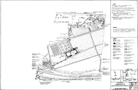
General design recommendations are organized into six program areas: Management Concepts, Interpretation Circulation, Structures, Vegetation, and Small-scale features. The final landscape plan is implemented in three phases: more detailed recommendations are included within each phase.
MANAGEMENT CONCEPTS
1) Reestablish the overall organization of the cultural landscape illustrating the extent of the historic development by reestablishing boundary-defining features such as fences, gates, roads, and paths. Interpret or reconstruct key HBC landscape features such as the garden, orchard, cultivated fields, Kanaka Village, the stockade, the river front, native vegetation, and circulation systems.
2) Clarify interpretive objectives for the Vancouver Barracks Parade Ground and the relationship between Vancouver Barracks and Fort Vancouver.
3) Restore, when accurate documentation exists and when possible, historic land use patterns and relationships related to the cultural landscape.
4) Materials and designs should be compatible with the historic period but should allow for contemporary maintenance practices, accessibility, and visitor safety concerns. Remove, relocate or screen contemporary intrusions that interfere with the historic scene, such as the maintenance storage area.
5) Designs, materials, and landscape treatments should be compatible with historic practices and used consistently throughout the park to provide visual continuity, and enhance the overall historic character of the park (including the noncontignous parcels).
6) All reconstructions and restorations must be based on accurate documentation. Implementation of the final plan is contingent on additional research and planning as outlined on pages 139 to 163.
INTERPETATION
1) In collaboration with park and regional staff, expand and implement the "Interpretive Prospectus" and incorporate the design recommendations outlined in the Cultural Landscape Report.
2) Expand the preservation and awareness of the park's archeological resources by undertaking additional archeological investigations and incorporating these ongoing projects into the park's interpretive programs.
CIRCULATION

1) Reestablish historic circulation routes based on historic documentation while protecting archeological evidence. As appropriate, establish pedestrian routes that provide access to all major historic landscape features such as the stockade, Kanaka Village, the river front, the garden, orchard, fields, and pastures. Follow historic routes when possible.
2) Reestablish the historic entry to the stockade by relocating the primary entrance and parking lot south/southwest of the stockade. The proposed entry road is to be connected to a proposed Highway 14 frontage road. The parking lot should be located in Zone II. No parking should be allowed within the core historic area (management zone I).
3) All parking lots and trails should comply with current accessibility standards, and should be compatible with the historic scene by being informal in character. The surface material should be soil and/or a compacted, crushed aggregate surface, treated to control dust, and roads should not have curbs.
4) Restore East Fifth Street to its historic appearance in order to mitigate contemporary traffic problems (vehicle speed) and for visual continuity. Replace asphalt with the same surface material used for the above circulation features.
STRUCTURES

1) All historic reconstructions should be maintained and included in a cyclic maintenance preservation program that addresses long-term preservation requirements for individual buildings.
2) Initiate archeological investigations to accurately locate non-extant historic structures that are important in understanding the historic character and function of the landscape. Based on this research, three levels of preservation treatment are recommended:
A) If a structure is not located archaeologically but its general location has been depicted on the historic base map, interpret the building or cluster of buildings with appropriate wayside exhibits/panels.
B) If a structure is accurately located, visually delineate the location of structures by constructing " post-on-sill" foundations.
C) If a structure is accurately located, reconstruction may be considered. Reconstructions should not be undertaken unless accurate archeological and historical documentation is available. When considering a reconstruction the following criteria should be met before it is approved:
a) There must be enough artifacts excavated and historical documentation available to accurately develop architectural construction drawings. Base the level of research required on the type and degree of research used for the existing stockade reconstructions;
b) Reconstruction of a building must be critical to the interpretation of the site;
c) In situ archeological material must not be adversely affected by the reconstruction.
3) Contemporary structures, except wayside exhibits and a fee station, should not be located in the core area (management zone I). Whenever possible, reconstructed historic buildings should be adaptively used for contemporary functions.
VEGETATION
1) Reestablish key cultural and native vegetation from the historic period including the garden, the orchard, cultivated fields, the pasture/prairie, and native vegetation such as the coniferous forest edge, the riparian edge, and landmark specimens such as the five Douglas-fir trees along Lower Mill Road.
2) Any remnant historic vegetation, such as the two Douglas-fir and two Oregon oaks on the parade ground, should be evaluated by a tree specialist and placed on a cyclic maintenance schedule. The pear tree north of East Fifth Street, that has been identified as an old variety, should be evaluated to determine if it is a species that originated in the historic period and could be grafted for the garden and/or orchard. Seeds from historic vegetation should be gathered to use as replacements when the historic vegetation dies.
3) In collaboration with resource management staff, prepare a comprehensive Vegetation Management Plan which addresses reestablishing the historic vegetation (introduced and native).
4) Whenever possible and as appropriate, mitigate the contemporary visual intrusions and create a visual boundary for the site by reestablishing the historic vegetation. For example, planting portions of the Douglas-fir forest west of Kanaka village serves two purposes, it screens the transportation corridor and reestablishes the historic scene.
5) Contemporary, non-native ornamental trees north of East Fifth Street should remain, unless there are safety concerns, until recommendations to reconstruct the historic vegetation are implemented. For aesthetic reasons, prior to implementation, a consultation with park staff and a historical landscape architect should occur to consider selective removal (rather than total removal) of trees.

SMALL-SCALE FEATURES
1) Determine the historic locations of small-scale features and when accurate documentation exists, reconstruct key features that enhance interpretation of the landscape, including fences, wells, belfry, gates, flagstaff, and cold (or hot) frames.
|
| (click on image for an enlargement in a new window) |
IMPLEMENTATION
INTRODUCTION
The preferred alternative was selected because of its ability to satisfy the primary design criteria established by the park and region at the time of the report and within the context of the existing project parameters. If these project parameters change in the future, some changes may have to be made to the landscape plan, however, the changes should still comply with the park's preservation objectives and the management concepts developed in this report. The preferred landscape plan addresses and meets the design criteria as follows:
a. The plan enhances interpretation of the HBC cultural landscape by interpreting and reconstructing key historic features including circulation routes, vegetation, structures, and small-scale features. The park's preservation treatment philosophy is reinforced by recommendations that preserve, restore and reconstruct key landscape features. The recommendations emphasize that reconstructions should only occur when they can be supported by accurate documentation and research.
b. The plan addresses several major circulation issues identified by the park and region during the project. Visitors enter the site from the southwest to reestablish the historic entry from the historic river front area, they travel through the historic gate along the road, and reestablish the primary historic entries to the stockade by entering through the two gates on the south side of the stockade. Vehicle access is provided from Highway 14.
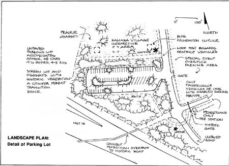
The visitor parking lot is relocated west of the stockade (outside Zone I), is within a reasonable walking distance from the stockade, and allows for overflow parking (across the historic river road for special events). This location acts as a boundary and buffer to contemporary development along the southwest corner of the park. A major advantage to this location is that the parking lot can be effectively screened and compliment the historic character by planting native trees and shrubs that were historically part of the conifer forest that extended into Kanaka Village. The parking lot location also ties into the proposed pedestrian overpass from Historic Apple Tree Park so that all visitors enter the cultural landscape from the same area. Although the historic resources of this area (Zone II) have been heavily impacted by contemporary development, the area is still important in terms of interpretation and visitor access to Kanaka Village. With careful planning and design, archeological resources in Kanaka Village should not be disturbed by constructing a gravel parking lot in this area.
c. The resources of the core historic area receive maximum protection in the plan because, except for interpretive trails and the fee station, no contemporary features have been developed in Zone I, and inappropriate contemporary uses such as a picnic area and maintenance storage area will be consolidated in the NPS administrative zone.
d. The plan restores the historic scene, provides visual continuity and distinguishes between HBC and U.S. Army resources by using materials that are appropriate for distinct areas. For example, HBC resources, the Vancouver Barracks parade ground, and NPS administrative area are distinguished by reestablishing historic vegetation for Fort Vancouver, maintaining the lawn and native trees of the parade ground, and maintaining contemporary plantings for the administrative area. In addition, recommended maintenance practices enhance the appropriate character for each area.
e. The design specifies that Federal accessibility and safety standards are met, but also recommend surface materials that are historically correct or compatible in character. For example, while existing documentation suggests that there was no defined path within the stockade, for accessibility, safety, and comfort reasons, a path will be constructed to allow easy access to all stockade features.
f. Contemporary visual intrusions such as the railroad berm, highways, army development, and proposed visitor parking lot, are screened in the plan by the reestablishment of historic native vegetation.
g. The design establishes a stronger link between the Columbia River and the stockade by increasing interpretation at the river front, and connecting the proposed WDOT pedestrian overpass to the main visitor entry point.
h. In Phase II of the plan, the visitor center will be relocated to a reconstructed building in the stockade, to consolidate major interpretive resources.
The landscape plan for Fort Vancouver is described in the framework of three implementation phases. Each phase reflects the overall objectives of the plan by defining a sequence of tasks and goals leading toward full implementation of the landscape plan. For several aspects of the plan--specifically related to reconstruction or long-term management goals--additional research or planning documents will be required. These are detailed to the degree possible within the scope of this project.
Compliance with the National Historic Preservation Act of 1966 and with the National Environmental Policy Act (NEPA) of 1969, must be met prior to implementation of any design treatments described in this report.
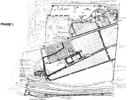
PHASE I
Overview
The objective of Phase I is to expand the interpretation of the cultural landscape at Fort Vancouver. Implementation of Phase I will clarify the boundaries of the historic landscape, both visually and physically. During this phase, additional research is initiated to identify and direct the appropriate treatments for Phase II and Phase III of the plan.
By the end of Phase I, the framework of the circulation system is in place, major research projects have been identified and initiated, a vegetation management plan has been developed to guide reestablishment and management of vegetation throughout the site, and interpretation has been expanded.
Phase I Tasks
Interpretation
1) In cooperation with park and regional staff, establish wayside exhibits for key landscape features along the proposed roads and paths. Wayside exhibits should be created for key landscape features (the stockade, Kanaka Village, the river front area); overall HBC agricultural operations (the garden, the orchard, fields, and pastures), historic circulation routes; structures; and small-scale features. Wayside exhibits should address the importance and characteristics of the individual features themselves, and how these features contribute to our understanding of the historic themes interpreted at Fort Vancouver. See Appendix F for a list of suggested wayside exhibits and locations.
2) The location of wayside exhibits interpreting landscape features should be placed with consideration to archeological resources. If a feature cannot be located archaeologically, the wayside should be sited in proximity to the location of the feature as depicted on the historic base map.
3) Support planning efforts by the U.S. Army to prepare a cultural landscape report for Vancouver Barracks. This report could provide a basis for management and interpretation of the Vancouver Barracks cultural landscape.
Circulation

1) Maintain the current vehicular routes from the NPS Visitor Center to East Fifth Street.
2) Maintain the existing parking lots, and existing pedestrian routes at the river front area.
3) Remove the remnant asphalt loop road that is located in the Kanaka Village site.
4) Reestablish key historic circulation routes based on historic documentation. Circulation routes include the overall historic road system, and any other roads or paths that are necessary for connecting different areas of the site such as the stockade, Kanaka Village, the river front, the garden, the orchard, fields, pastures, and the visitor center.
For visual continuity, materials for all roads, paths, and parking lots should be compacted soil/crushed aggregate, or asphalt with a compacted surface material. The surface materials should match the existing soil in color and texture. Wood post bollards should be installed to control vehicular access across historic roads that are used solely for pedestrian circulation.
5) Work with the army to reestablish the historic road (river road) from East Fifth Street to the southwest edge of the park. In lieu of this access across Army property, construct a road from East Fifth Street along the north edge of NPS property that connects to the reconstructed historic river road.
6) Construct a permanent parking lot at the south end of the river road, on the west side of the road. The parking lot should accommodate approximately forty-five cars, five recreational vehicles (RVs), and five to six buses. Construct an accessible path from the parking lot across the river road to historic Upper Mill Road. Provide a small-scale shuttle system for handicap access. Screen the parking lot with appropriate historic vegetation (plant material from a conifer forest transition zone).
7) Provide two to three parking spaces in a small gravel lot adjacent to the stockade for maintenance and safety vehicles. If a shuttle system is not feasible for handicap access, provide two to three (additional) handicap spaces in this lot.
8) Allow parking across the road from the permanent parking lot, for special events when extra parking is required.
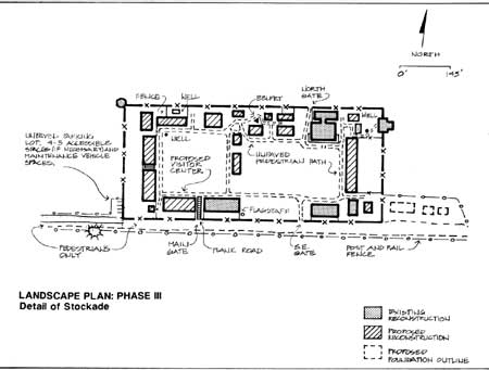
9) Construct an accessible path around the perimeter of the stockade providing access to all historic features.
10) Reconstruct the historic plank road between the southwest gate and the interior areas of the stockade.
11) Provide pedestrian access through all three of the stockade's historic gates.
12) Construct an accessible path to the river's edge and a compacted soil/crushed aggregate interpretive trail along the river to the east end of the park. Coordinate planning this trail with any water front trails proposed by the City of Vancouver, WA.
13) Collaborate with the Washington Department of Transportation (WDOT) on plans to construct the pedestrian overpass (planned for during the Interstate 5/Highway 14 construction project during the 1980s). The overpass should provide access from Historic Apple Tree Park to the intersection of the historic river road and historic Upper Mill Road.
Structures

1) Maintain and preserve the existing historic reconstructions in the stockade as a part of a cyclic maintenance program.
2) Maintain and preserve the existing army bandstand (reconstructed) on the parade ground as a part of a cyclic maintenance program.
3) Maintain the use of the visitor center/administration building.
4) Remove the maintenance storage area that is located in the Kanaka Village Site.
5) Conduct archeological investigations, in consultation with the Regional Archeologist, to locate historic structures in the garden (summerhouse), orchard (unidentified structure), fields (barn complex, root houses, and the two HBC schoolhouses), and adjacent to the stockade (the Cooper's Shop and other potential structures outside the S. E. corner of the stockade).
6) Initiate archeological investigations to relocate the foundations of previously excavated historic structures inside the stockade. Remove the existing asphalt pads and delineate relocated building foundations by reconstructing the "post-on-the-sill" foundations. Work with historical architects and archeologist to determine the cost analysis for building foundation outlines for identification purposes versus foundations that act as structural bases for future reconstructions. See Alternate Construction Systems and Alternatives to Total Reconstructions of Structures at Fort Vancouver National Historic Site. A. Lewis Koue, 1981.
7) Construct a fee station on historic Lower Mill Road just inside the proposed historic entry gate.
8) Provide storage for tools and equipment necessary to maintain the agricultural operations of the park in reconstructed structures.
9) Any contemporary structures constructed in the NPS administrative area (Zone IIIa) should match the design character of the existing non-historic structures.
10) Contemporary structures, except for wayside exhibits, should not be constructed on the parade ground (Zone III).
11) Prepare a visual compatibility guidelie for development at the river front area. Assess the existing park facilities, to determine what, or if, features should be compatible with the historic character. The designs and materials of interpretive displays, and contemporary small-scale features, and structures, should be consistent with the remainder of the river front area.
12) Construct facilities in the river front area to establish a visitor contact point for interpretation.
13) Delineating non-extant historic buildings, and/or reconstructing historic structures and small-scale features at the river front is not recommended due to a lack of historic documentation and severe impacts to this area. If site impacts are eliminated and accurate documentation of the historic physical development of this area becomes available, the park could consider expanding the development of the river front area.
Vegetation

1) In collaboration with a historical landscape architect and horiticulturists, retain selected fruit trees in the existing orchard to help spatially define the limits of the historic garden. Some non-historic fruit trees should be retained to serve as interpretive plant material until further research on the orchard and garden is completed. Trees that are diseased, in poor condition, or fall within reconstructed historic garden paths should be removed.
2) Maintain the lawn, and existing Douglas-fir and Oregon oak trees on the parade ground. No new ornamental trees or shrubs should be planted on the parade ground.
3) Maintain the open field/meadow appearance of the field south of the stockade by retaining grasses, and removing any volunteer and/or non-native trees and shrubs.
4) Maintain the existing ornamental species and lawn around the NPS administrative area. The interpretive trail will act as a transition and border between the contemporary NPS area and the core historic area.
5) Maintain any existing riparian vegetation along the Columbia River.
6) Retain the existing open views to the Columbia river from the historic river front industrial area.
7) Support the passive recreational use of the river front area by maintaining the lawns and ornamental plantings around the parking lot.
8) In consultation with the Corps of Engineer's (in case of rip-rap features), remove debris and intrusive structures such as concrete and building ruins, from the Columbia River shoreline in preparation for restoration of the riparian environment.
9) Initiate research to complete an authentic and appropriate plant list for the historic garden, orchard, cultivated fields, livestock pasture, and native vegetation (conifer forest, riparian edges, prairie grasses, etc.). A list of nursery sources for the historic plant material should also be developed. See Appendix A for a preliminary list of native species and Appendix G for recommended primary and secondary plant material sources and the preliminary criteria for reconstructing historic agricultural features.
10) Initiate research to develop a detailed layout of the historic garden and orchard, based on specific documentation about Fort Vancouver if possible. If no primary sources are identified, use secondary sources (see Appendix G.).
11) Initiate research on the agricultural methods used at Fort Vancouver in the garden, orchard, fields and pastures, in order to incorporate these historic methods whenever possible or economically feasible. This should include planting and harvesting techniques, plant varieties and spacing, soil preparation, pest management, etc. For example, for the cultivated fields, management recommendations on crop rotation, manuring, and allowing fields to lie fallow, etc., should be investigated.
12) Relocate the existing interpretive garden to its historic location. Plant only a portion of the historic garden (one bed), until research identifying the appropriate historic species is completed, and the availability of those historic varieties is determined.
13) Plant a few historic apple trees in each corner of the historic orchard site (until all research is completed), to define the orchard boundaries. Plant standard rootstock and after obtaining permission from the City of Vancouver, use grafts from the Historic Apple Tree as one of the historic varieties for the orchard.
14) In collaboration with regional and park resource staff, develop a comprehensive Vegetation Management Plan to reconstruct the historic scene including the garden, orchard, fields, pastures, and native vegetation (prairies, riparian edge, and conifer forests). This plan should be based historic research developed in the Cultural Landscape Report and proposed research. It should be implemented in two parts, part one should be a partial reconstruction of the historic vegetation to serve as interpretive features. Part two should be a total reconstruction of historic vegetative features in order to function as a living history park and heirloom plant study center. Full reconstruction of the cultural landscape will entail the addition of new and/or supplementary infrastructure and administrative support from other interested organizations (agricultural leasing programs, horticultural research programs, garden clubs, and historical societies). Agreements between the NPS and other organizations should be detailed in the Vegetation Management Plan and include long-term commitments from all involved parties.
The plan should include sections on:
Descriptions of current vegetative conditions and the historic vegetative scene; goals and objectives of the plan; a process to implement historic vegetative reconstructions for the garden, orchard, fields, pasture, riparian edge, conifer forest, prairie grasses; maintenance techniques (historic or modern as appropriate) to maintain the historic scene; and guidelines for managing and distributing harvested produce and crops.
Small-scale Features

1) Maintain the existing post and rail boundary fences. For example, the fences around the Vancouver Barracks parade ground, the NPS administrative zone (residences and maintenance area).
2) Relocate existing picnic tables in the park to an area southeast of the visitor center.
3) Maintain benches, and picnic tables in the river front park area.
4) Reconstruct key small-scale historic features that help physically define more discrete areas within the landscape and add texture to the interpretive environment, including fences, the entry gate on Lower Mill Road, the flagstaff, belfry, wells, and cold/hot frames. Reconstructions should be based on accurate documentation. Initiate research for small-scale features with incomplete documentation (garden cold/hot frames and garden well). Two historic fence styles should be used as required throughout the site: post and rail, and zigzag (see Landscape Plan). Post and rail fences should be used around the garden, on the north and south sides of the orchard, and in fields adjacent to the stockade. Zigzag fences should be used along the west side of the orchard and around outlying fields.
|
| (click on image for an enlargement in a new window) |
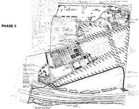
PHASE II
Overview
The objective of Phase II is to expand the interpretation of the cultural landscape and begin implementation the vegetation management plan completed in Phase I. Additional research and planning necessary for the implementation of the final landscape plan in Phase III, will be continued in this phase.
By the end of Phase II, the final circulation system is in place, a layer of detail is added to the historic scene, and interpretation is expanded to a level that meets the objective of the park's interpretive mandate. If additional funding and documentation are a not available for implementing Phase III, Phase II may be considered the final phase for the landscape plan.
Phase II Tasks
Interpretation
1) Provide additional wayside exhibits and/or additional information for key features that were identified or investigated in Phase I research.
2) Implement design recommendations for the river front area from the Visual Compatibility Guidelines completed in Phase I.
Circulation

1) Maintain, or expand if necessary, the interpretive wayside and view point of the overall fort landscape located southwest of the visitor center that was constructed during Phase I.
2) Reduce the size of the existing visitor center parking lot (see suggested change on the Landscape Plan).
3) Construct the main entry road to the park by extending the Washington Department of Transportation's proposed Highway 14 frontage road, to the southeast edge of the park. Provide a small parking lot, a viewpoint and wayside exhibit, and a vehicle turn around at the southeast corner of the park. The entry road should connect to the proposed historic road north of the prairie/pasture.
4) If the historic river road was not reestablished in Phase I, work with the army to reestablish this route. In lieu of access across army property, maintain the road constructed in Phase I, north of the garden and orchard, that connects East Fifth Street to the river road.
5) If the army property located south of East Fifth Street and east of the historic river road is purchased by the NPS, and if the Vancouver Barracks resources are determined to be historically insignificant, reestablish the remainder of the historic garden paths.
6) Work with the Washington State Department of Transportation in construction of the proposed pedestrian overpass from Historic Apple Tree Park to the southwest corner of NPS property.
Structures

1) Maintain the foundation outlines constructed for buildings in the stockade in Phase I.
2) Maintain the administrative offices in the original visitor center/administration building after the visitor facilities are relocated to the stockade.
3) Relocate the visitor center to the stockade, in a historic building reconstructed near the main (southwest) gate, preferably the Provision Store (First Fur Store).
4) Based on building locations established in Phase I archeological investigations, construct post-on-the-sill foundation outlines, for all key historic buildings inside and outside the stockade. Work with historical architect to construct foundation outlines that serve as interpretative features rather than structural elements. See Alternate Construction Systems and Alternatives to Total Reconstructions of Structures at Fort Vancouver National Historic Site A. Lewis Koue, 1981.
5) Initiate archeological investigations in Kanaka Village to relocate the structures excavated in previous investigations.
Vegetation

1) Obtain and evaluate soil samples in all planting areas and supplement/amend the soil as necessary for planting the garden, orchard, fields and pasture.
2) Begin implementation of the vegetation management plan by partially reconstructing historic vegetation for interpretive purposes.
A) Partially reconstruct the garden and orchard. Plant one to three of the historic garden beds and fifty to sixty fruit trees (for the entire historic orchard area) as depicted on the landscape plan. If the army owned portion of the historic orchard is not acquired by the NPS, plant approximately twenty to thirty trees in the orchard.
B) Partially reconstruct cultivated fields. Partial planting for fields with row crops should consist of planting the perimeter of the fields in a thirty to forty foot wide section. Fields with cover crops (tares, clover, etc.) could be planted entirely. The portions of cultivated fields that are not planted should be ploughed two to three times a year to maintain an agricultural appearance, if archeological resources can be protected. Implement agricultural leasing agreements, and/or initiate support by other agencies to actively cultivate and maintain fields as developed in the vegetation management plan.
C) Plant the historic pasture (open field south of the stockade) with appropriate native grasses, timothy and clover.
D) Reestablish a vegetative cover that is compatible with the historic character. For example, areas adjacent to fields and around structures that historically consisted of prairie species should be planted with native vegetative materials or materials that match native species in color, growth habit, and texture.
E) Reestablish portions of the Douglas-fir forest that was located historically west of the village extending to Kanaka Village. Vegetation should be planted in locations that will not adversely affect the archeological resources. In addition to reestablishing the historic scene (forest transition zone vegetation), restored vegetation should be sited to screen the contemporary army development, major highways, and the proposed NPS parking lot. Reestablished portions should include:
a) A screen of Douglas-fir trees planted along a portion of the western and southwestern edge of NPS property.
b) Individual and clusters of Douglas-fir trees planted in the historic Kanaka Village area.
F) Establish a screen of riparian vegetation north of Highway 14. The vegetative screen should consist of a band or mass of trees and shrubs, with selected view corridors to provide vistas from the highway into the park.
G) Reestablish the four Douglas-fir trees historically located along Lower Mill Road and the single Douglas-fir that existed west of the stockade.
H) Plant the beds and vines associated with the Chief Factor's house.
3) If the army property, located south of East Fifth Street and east of the historic river road, is acquired by the NPS and if the Vancouver Barracks resources are determined to be historically insignificant, expand the garden and the orchard to their historic dimensions.
Small-Scale Features

1) Replace the existing post and rail boundary fences with zigzag fences, except where safety and security are a concern and existing chain-link boundary fences should be maintained. For example, the chain-link fence north of Highway 14.
2) Identify and interpret, or reconstruct key small-scale features that were located during Phase I archeological investigations. Reconstructions must be based on accurate documentation and be necessary for interpreting the landscape. For example, if an appropriate design for cold and/or hot frames is identified, reconstruct one or two if they are necessary to interpret the garden. Reconstructed frames should be located along the east edge of the eastern historic garden beds. If reconstructions are not appropriate or feasible, provide wayside exhibits.
3) If the army property located south of East Fifth Street is purchased by the NPS, and if the Vancouver Barracks resources are determined to be historically insignificant, reconstruct the remainder of the historic fences associated with the garden, orchard and roads.
|
| (click on image for an enlargement in a new window) |
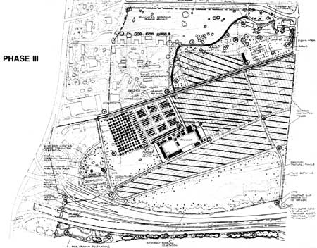
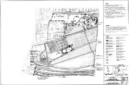
PHASE III
Overview
The objective of Phase III is to fully expand the park's development and interpretation to function as a living history park, HBC research center, and heirloom plant study center. During Phase III, the vegetation management plan will be fully implemented. The final plan represents the full extent of reconstruction and should be carried if two major criteria are satisfied. It must be based on accurate documentation, and the infrastructure and administrative support necessary to support a living history park and heirloom plant study center must be secured before the phase is implemented.
At the end of Phase III key accurately documented HBC structures will be reconstructed, accurately documented historic vegetation will be reconstructed, and interpretation will be further enhanced with the reconstruction of accurately documented small-scale features.
Phase III Tasks
Interpretation
1) Expand the park's interpretation to include additional research on features identified and/or restored in Phase I and II.
2) If the army property west of historic Kanaka Village is acquired, expand the interpretation of Kanaka Village and designate the area as a priority archeological excavation area for archeological field schools, with the potential to use the site as a demonstration area for the interpretation of the park's archeological resources.
Circulation

1) After the visitor center is relocated to the stockade (in Phase II), remove the asphalt surface of the existing road from the visitor center to East Fifth Street and replace it with the same material used for the other circulation routes. If the two HBC schoolhouses were accurately located in Phase I, and the existing road runs across either building site, realign the road west of the buildings.
2) Replace the asphalt road and concrete sidewalks along East Fifth Street (within the park) with the same surface material used for other circulation routes.
Structures

1) Reconstruct all the historic buildings within the stockade, (if accurate documentation is available).
2) Reconstruct the barn and root houses if these facilities are needed to support the agricultural activities of the fort (stables, farm equipment, etc.), and there is enough documentation to support a reconstruction. If the barn(s) and root houses are not reconstructed and storage facilities for agricultural operations are still needed, store equipment in maintenance structures or construct appropriate structures outside the historic core.
3) If the security of Kanaka Village can be assured, construct post-on-the-sill foundation outlines in the locations of historic structures in Kanaka Village located during Phase II. Otherwise, maintain the interpretive exhibits from Phase I.
Vegetation

1) Fully reconstruct the garden, orchard, cultivated fields, pasture, and historic native vegetation if the research and infrastructure supports a living history farm and heirloom plant study center. If is not feasible to completely reconstruct features, maintain the partially reconstructed features planted in Phase II for interpretation.
2) Restore the Columbia River's riparian edge to its natural condition, if feasible.

Small-Scale Features
1) Reconstruct any additional key small-scale features that were documented in Phase I or II. For example, reconstruct the garden well, and additional garden cold/hot frames (four to five total), if they are necessary for garden operations and if an appropriate design was established in Phase I or II.
2) Reconstruct key small-scale features in Kanaka Village that were identified in Phase I or II research, only if the security of the area's archeological resources can be assured.
|
| (click on image for an enlargement in a new window) |
|
| (click on image for an enlargement in a new window) |
|
| (click on image for an enlargement in a new window) |
|
| (click on image for an enlargement in a new window) |
| <<< Previous | <<< Contents >>> | Next >>> |
fova/clr/chap4-1.htm
Last Updated: 27-Oct-2003