FORT VANCOUVER
The History of Fort Vancouver and its Physical Structure
|

|
PLATES
|
|
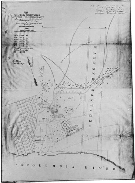
Plate XXI—Plan of Fort Vancouver and Vicinity, 1859. Section of Map of the Military Reservation at Fort Vancouver, W. T.,
Surveyed under the Direction of Capt. Geo. Thom, Topographical
Engrs. by Lieuts. J. B. Wheeler & J. Dixon . . . by Order of Brig. Gen. W.
S. Harney, 1859, in General Land Office Records, Abandoned Military
Reservation Series, Ft. Vancouver, Washington, Box 100, in the
National Archives. (click on image for a PDF version)
|

|
|
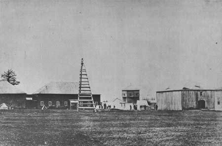
Plate XXII—Northeast Corner of Courtyard, Fort Vancouver, May, 1860,
Showing the "Priests' House," the Manager's Residence, and the
Bachelors' Quarters. Photograph No. 3 filed by the United States, in British and
American Joint Commission, Records, MSS, in General Records Division, State
Department, in the National Archives.
|
|
|
Plate XXIII—Northwest Stockade Corner, Fort Vancouver, May, 1860, Showing Store
house No. 2, the Trading Shop, the Blockhouse, the Granary, and the
Office. Photograph No. 3-1/2 filed by the United States, in British
and American Joint Commission, Records, MSS, in General Records Division, State
Department, in the National Archives.
|

|
|
Plate XXIV—Ground Plan of Fort Vancouver, June 15, 1860. From Proceedings of a Board of Officers, Which Convened at Fort
Vancouver, W. T., June 15, 1860, MS, in A. G. O., Oregon Department,
Document File, 212-S-1860, in War Records Division, the National
Archives. (click on image for a PDF version)
|
|
|
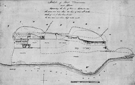
Plate XXV—Sketch of Fort Vancouver and Plain, Representing the Line of
Fire in September, 1844. From the original in the archives of the Hudson's Bay Company, through
the courtesy of the Governor and Committee of the Hudson's Bay
Company. (click on image for a PDF version)
|
fova/hussey/plates5.htm
Last Updated: 18-Feb-2008
|