
|
Geological Survey Bulletin 1309
The Geologic Story of Isle Royale National Park |
WHAT HAPPENED WHEN?
(continued)
THE GLACIERS TAKE OVER (continued)
Glacial Effects On The Land
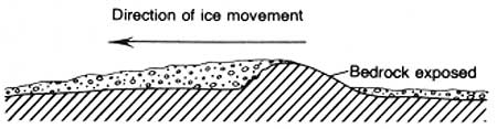
The effects of glacial erosion were strongly dependent upon the nature of the bedrock. Over much of the Canadian Shield, where the bedrock consists of granite and other resistant Precambrian rocks, the ice sheets probably did little more than remove surficial materials, weathered rock, and minor amounts of bedrock. However, where the bedrock consisted of softer, sedimentary rocks, as along the axes of each of the Great Lakes, the ice sheet deepened the preglacial lowlands to form the present lake basins. During the excavation of the Lake Superior basin, Isle Royale remained a ridge because its volcanic rocks resisted erosion.
Plucking and Abrasion
Glacial erosion of bedrock includes two distinct processes: plucking and abrasion. Glacial plucking or quarrying is the lifting out and removal of fragments of bedrock by the ice, whereas glacial abrasion involves grinding and polishing of the bedrock surface by rock fragments imbedded in the base of the moving ice sheet. Plucking is by far the more effective in altering the landscape.
Glacial plucking is controlled chiefly by bedrock structures, particularly preexisting joints or other fractures. The sedimentary rocks and amygdaloidal zones at the base and top of flows are less resistant to abrasion than the massive flow interiors, and the sedimentary rocks and thinner flows have closer spaced jointing than the massive interiors of the thicker flows. The alternation of massive, poorly jointed rock and highly jointed rock that guided the development of the preglacial topography by stream erosion also was the major control for glacial quarrying. The main role of glacial erosion on Isle Royale thus was to accentuate the asymmetry of the existing ridge-and-valley topography that had been formed earlier by stream erosion and to interrupt the preglacial stream channels with a series of small lake basins scooped out of the bedrock.
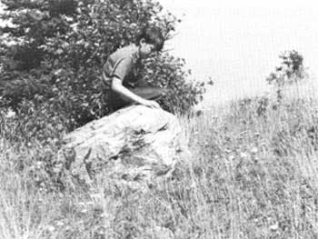
Whereas glacial quarrying modified the gross topography of Isle Royale, glacial abrasion rounded, polished, and striated many rock outcrops (figs. 47, 48). The quarrying and scouring together were so effective, in fact, that deeply weathered rock, which we would expect to find after millions of years of weathering, is found only rarely on the island on the lee sides of a few outcrops where the weathered rock was protected from the action of moving ice.
|
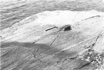
| GLACIAL STRIATIONS near Moskey Basin Campground. (Fig. 47) |
|
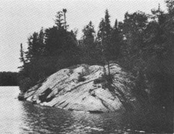
| GLACIALLY ROUNDED AND STRIATED OUTCROP near portage trail at Pickerel Cove. (Fig. 48) |
Striations
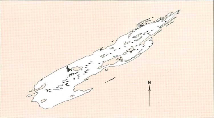
Glacial striations on the bedrock not only indicate the former passage of glacial ice but also provide an indication of the general direction of movement of the ice that formed them (fig. 49). The striations indicate that the last ice movement on the east half of the island was toward the southwest, parallel to the bedrock ridge-and-valley topography. On the west half, striations indicate that the direction of movement was westward, crossing the ridges and valleys at an angle. The westerly direction is roughly perpendicular to a series of glacial moraines, or ridges of glacial till, that crosses the island near its west end; these moraines mark a pause in the retreat of the ice sheet. Southwesterly striations near the north side of the southwest end of the island presumably reflect the direction of the main advance down the Lake Superior basin prior to retreat to the position of the glacial moraines. Glacial striations are rarely preserved on the sedimentary rocks because the surfaces of those rocks weather and disintegrate relatively rapidly. Striations are best preserved on the denser, nonamygdaloidal volcanic rocks and can best be seen along shorelines where such rocks dip gently into Lake Superior or along shorelines of some of the larger inland lakes. Such locations are along the north shores of Tobin Harbor, Rock Harbor, Pickerel Cove, Lake Richie, Siskiwit Lake, and the west end of Moskey Basin. Striations can also be seen along many of the inland trails, especially in places where the trail itself has channeled rainfall runoff so as to remove the soil cover and expose fresh bedrock.
|
| DIRECTION OF GLACIAL ICE MOVEMENT as indicated by striations and other glacial features. Dark areas are recessional moraines. (Fig. 49) (click on image for an enlargement in a new window) |
Till
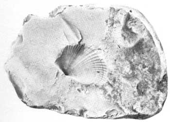
On the east half of Isle Royale, where the last ice advanced approximately parallel with the ridge-and-valley topography, surficial deposits other than a thin mantle of soil and rock debris are confined to valleys and smaller depressions, and conversely outcrops are relatively abundant except in the valleys; heterogeneous glacial deposits called till are not apparent. Scattered boulders of foreign rocks, called glacial erratics, do indicate the presence of glacially transported materials, but they are not overly abundant. Beach gravels along the present shoreline are predominantly derived from nearby bedrock, although they contain pebbles reworked from glacial materials. The most obviously foreign pebbles are of granitic rocks from the Canadian mainland and fossiliferous limestone and chert from the Hudson Bay area (fig. 50).
|
| FOSSIL SHELL in chert pebble. (Fig. 50) |
Near the west end of Siskiwit Lake, where the westward direction of ice movement crossed the trend of the ridges and valleys at an angle of about 25°, glacially deposited materials are more abundant; thin glacial till mantles many of the slopes, and outcrops decrease in size and number. Large erratics are numerous.
Till is abundant on the west end of the island, effectively concealing most of the bedrock and subduing the landforms (see title page). Large erratics also are abundant (fig. 51). Bedrock outcrops are mainly limited to small knobs and the steep north faces of some ridges. In many places, even these bedrock exposures have clearly been excavated from till by wave action at a time when Lake Superior was higher than now.
|
| ERRATIC BOULDER of granite near crest of Feldtmann Ridge. (Fig. 51) |
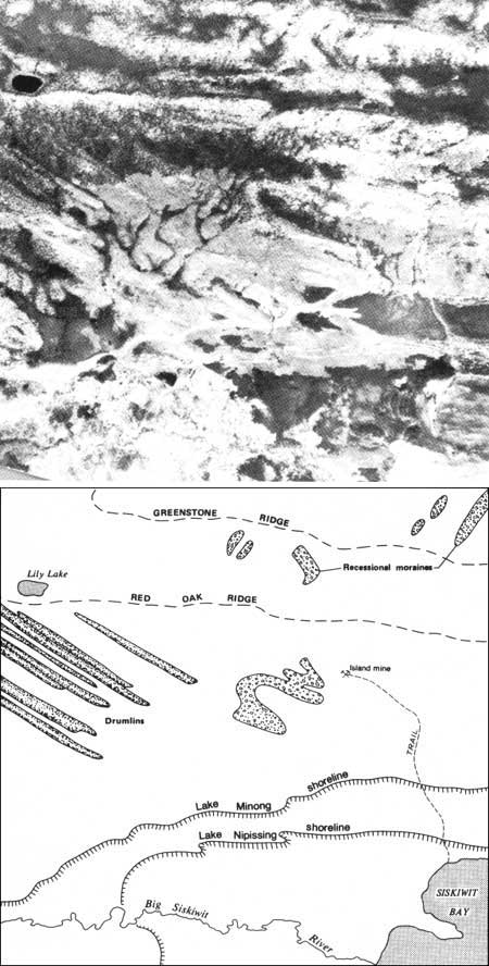
Drumlins.—West of Siskiwit Lake, where the till becomes more abundant, one can see deposits of till with distinctive shapes, certain of which are called drumlins. A drumlin is a streamlined hill or ridge of glacial till elongate in the direction of flow of the glacier that formed it. The drumlins on Isle Royale are of the crag-and-tail variety—linear ridges streamed out behind a bedrock knob (fig. 52). The drumlins vary in length from a few feet to nearly 2 miles; the larger ones can be seen on the shaded-relief map (see title page) and on aerial photographs as distinct east-west ridges superimposed upon the movement bedrock-controlled, northeast-trending ridges (fig. 53). They are most abundant between the west end of Siskiwit Lake and a locale about 5 miles east of Cumberland Point. In an area west of Siskiwit Bay covering several square miles, the only bedrock exposed is at the heads of the drumlins. The elongation of the drumlins is useful to determine the direction of ice movement in areas where glacially striated bedrock is not exposed.
|
| CRAG AND TAIL DRUMLIN—cross section (Fig 52) |
|
| GLACIAL FEATURES FROM AIR including drumlins abandoned shorelines, and other features of glacial origin west of Siskiwit Bay. (Fig. 53) |
Recessional moraines.—A series of till—built recessional moraines that was formed during a pause in the retreat of the last ice sheet crosses the island in a general northerly direction west of Lake Desor. (See fig. 49). The form of these deposits is distinctive and can be generally characterized as an arc-shaped ridge roughly transverse to the direction of ice movement and not controlled by bedrock structure. The deposits define the former position of an irregular ice front controlled by topography, with tongues of ice extending into valleys or low areas in front of the main ice mass. (See fig. 59.) The ice front was not completely static, however, and continued to retreat by small increments. This intermittent retreat is best illustrated by the succession of moraines on the south flank of Mount Desor that were constructed by the ice lobe that extended up the drainage basin of the Little Siskiwit River.
| <<< Previous | <<< Contents >>> | Next >>> |
bul/1309/sec5c.htm
Last Updated: 28-Mar-2006