
|
Geological Survey Bulletin 1327
The Geologic Story of Canyonlands National Park |
THE HIGH MESAS
Even though the "peninsular" mesas east and west of Island in the Sky, known respectively as Hatch Point and the Orange Cliffs, lie outside the present boundaries, they provide breathtaking views of important features within the park, so brief descriptions of them are included below. But first, let us take a closer look at Island in the Sky.
Island in the Sky
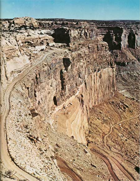
As the map (fig. 1) shows, Island in the Sky is really a fork of a wedge-shaped peninsula extending southward between the two rivers. An outlier to the south named Junction Butte has already been severed from the main peninsula by erosion and now is a true island. (See frontispiece and fig. 22.) A large chunk of Island in the Sky south of The Neck was about to be severed by erosion from the main peninsula to become a true island, when recent widening and grading of the road gave it a temporary reprieve. When my family and I first squeaked over this narrow neck in 1960 by jeep, furtive glances to right or left showed the two canyons perilously close, and complete severance seemed imminent. The road builders have staved off disaster for a few thousand years, but ultimately the large section to the south will become another island, and a bridge will be required to connect it to the mainland. Its appearance from the air before the road widening is shown in figure 11.

|
| AERIAL VIEW OF THE NECK AND SHAFER TRAIL, looking southwest, taken before rebuilding of park road on mesa top. Cliff-walled canyon to right of The Neck, in middle, drains westward to the Green River; south fork of Shafer Canyon to left drains eastward to Colorado River. This is the narrowest part of Island in the Sky. Photograph by National Park Service. (Fig. 11) |
The entrance road to Island in the Sky intersects U.S. Highway 163 at a point 10 miles northwest of Moab, or 21 miles southeast of Crescent Junction on Interstate Highway 70. From U.S. 163 a paved road climbs colorful Sevenmile Canyon past sandstone cliffs of the Wingate, Kayenta, and Navajo Formations to reach the high mesa. There, just "offshore" to the north, are anchored the "battleships" that guard the island—Merrimac and Monitor Buttes (fig. 12). These landmarks are composed of the Entrada Sandstone—the same rock that forms Church Rock at the entrance to the Needles district (fig. 37) and that shapes the spectacular arches in Arches National Park. All three members of the Entrada (Wright and others, 1962), as noted in the figure 12 caption, are present here as well as at Church Rock. Eleven miles from the junction with U.S. Highway 163 a graded road to the right, called Horsethief Trail, goes 16 miles down to the Green River, where it connects with roads following the river both upstream and downstream. The road upstream leads to two uranium mines in the lower part of Mineral Canyon which were reactivated in 1972 and 1973. The switchbacks are quite spectacular and are reminiscent of the Shafer Trail. Three miles south of the Horsethief Trail turnoff is a fork in the road—to the left the pavement continues to Dead Horse Point, and straight ahead a graded road leads southward to the Island in the Sky district of Canyonlands National Park.

|
| MERRIMAC (LEFT) AND MONITOR BUTTES guard north entrance to Island in the Sky. White rock near middle is Navajo Sandstone. Buttes comprise all three members of Entrada Sandstone: remnant white top of Moab Member, vertical cliffs of Slick Rock Member, and sloping base of Dewey Bridge Member. (Fig. 12) |
Most of Island in the Sky has a scattered growth of piñon and juniper trees, but several large flat areas, such as Grays Pasture, contain sufficient sandy soil to support a mantle of grass and weeds, which is used for grazing; however, grazing in this part of the park will be discontinued in 1975.
DEAD HORSE POINT STATE PARK
Let us follow the paved road from U.S. Highway 163 all the way to Dead Horse Point, which was set aside as a state park in 1957. The park has a visitor center, museum, modern campgrounds and picnic facilities, and piped water, which is hauled all the way from Moab. An entrance fee of $1 permits us to drive across the narrow neck to a parking area near the point proper, which is protected by stone walls and is provided with a ramada, benches, paths, and sanitary facilities. From Dead Horse Point we get breathtaking views in several directions, including a loop of the Colorado River called the Goose Neck, 2,000 feet nearly straight down.

|
| CANE CREEK ANTICLINE, looking northeast toward the La Sal Mountains from Dead Horse Point. Colorado River cuts across crest at middle right, above which is Anticline Overlook. (See fig. 31). Jeep trail and part of Shafer dome line below. (Fig. 13) |
How did such a magnificent viewpoint get such a macabre name? Dead Horse Point was named for a sad but colorful legend concerning a band of wild horses that once roamed the high mesas. The point is really an embryo island separated from the mainland by a narrow neck barely wide enough for the present road. In the early cowboy days the island was used as a natural corral in which wild mustangs were penned up behind a short fence across the neck so that the better ones could be sorted out and driven to mines in the San Juan Mountains of Colorado. A band of horses corralled too long without water allegedly died of thirst within sight of the river 2,000 feet below, hence the name of the point, or at least so one version of the story goes. Some versions allude to the wranglers as cowboys; others, as horsethieves.
To the northeast we can see the Cane Creek anticline—an upward fold of the rocks—behind which loom the La Sal Mountains (fig. 13). A cutaway view of a typical anticline is shown in figure 14. A better view of the Cane Creek anticline can be seen from Anticline Overlook, as shown in figure 31. From our vantage point at Dead Horse Point, we can see much of Hatch Point, including Anticline Overlook, by looking east and southeast. Spectacular views of the northern part of Canyonlands National Park lie to the south, southwest, and east. Looking southwest (fig. 15), we see most of the rock formations exposed in Canyonlands—more than can be seen from any other vantage point in or near the park. The names of the visible rock units shown in figure 15 can be compared with the complete list in the rock column (fig. 9). Parts of Shafer dome, a "closed" rounded anticline, are visible in the lower left of figure 15 and in the lower right of figure 13. Its general domelike shape is outlined by the bluish-white Shafer limestone, a marker bed which also caps the bench on the peninsula within the Goose Neck of the river. This limestone, which here forms the top of the Rico Formation, is not shown in the rock column (fig. 9) because its exposure is limited to the Shafer dome and the Cane Creek anticline and its name is used only locally by prospectors for oil and gas.

|
| CUTAWAY VIEW OF ANTICLINE, or upfold of the rocks. From Hansen (1969, p. 31). (Fig. 14) |

|
| LOOKING SOUTHWEST FROM DEAD HORSE POINT toward Island in the Sky on right skyline, Orange Cliffs on left skyline, Colorado River and White Rim Trail below, and Shafer dome at lower left. Sketch from photograph shows names of rocks. (Compare with fig. 9.) (click on image for an enlargement in a new window) (Fig. 15) |
Note that the White Rim Sandstone Member of the Cutler Formation, referred to hereinafter simply as the White Rim Sandstone, becomes thinner toward the right (northeast) in figure 15 but is absent entirely in figure 13, just a short distance to the northeast. The gradual disappearance of recognizable beds of this type toward the northeast, including the disappearance of some limestone beds containing marine fossils, are examples of what geologists call facies changes. Here the changes result from the fact that while strata were being deposited in or near ancient seas that lay to the southwest, beds of different character were being laid down on land by streams, emanating from the northeast. This will be gone into in more detail in discussions that accompany illustrations to follow, particularly figures 27, 31, and 35.
NORTH ENTRANCE
The north entrance to the Island in the Sky district of Canyonlands National Park used to be 6 miles south of the junction with the paved road to Dead Horse Point, but since the land additions of November 1971, it is only 4-1/2 miles south of this junction. A temporary trailer-housed entrance station marks the old boundary.
SHAFER AND WHITE RIM TRAILS
During the early 1950's a remarkable but hair-raising road known as Shafer Trail was cut down the face of the cliffs below The Neck to reach the C Group of uranium claims near the head of Lathrop Canyon. It branches southward from the park road a mile south of the new entrance, then descends in a series of switchbacks. The aerial view (fig. 11) shows the upper trail and The Neck before the park road was graded and widened, and a view from near The Neck (fig. 16) shows the precipitous cliffs the trail descends. It follows the general route of an old foot trail.
|
| SHAFER TRAIL, from just south of The Neck (figs. 1, 11). Navajo Sandstone is above road at left, Kayenta Formation forms upper half of cliff below road, and Wingate Sandstone forms lower, vertical half of cliff; lower part of road is in Chinle Formation. (Fig. 16) |
Shafer Trail connects with the White Rim Trail, which, as the name suggests, is built mainly on the White Rim, after which the White Rim Sandstone was named. The White Rim Trail can be followed northeastward to join the pavement at Potash, or it can be followed southward along the Colorado River canyons to Junction Butte, thence northward along Stillwater and Labyrinth Canyons of the Green River to and beyond the northern boundary of the park. At Horsethief Bottom, you can leave the canyon by Horsethief Trail and rejoin the paved road leading northward to U.S. 163. At Lathrop Canyon, 8 or 10 miles south of where Shafer Trail meets the White Rim Trail, a branch of the White Rim Trail leads downward to the Colorado River, where picnic tables and sanitary facilities are provided. This is used as a lunch stop by some boating groups.
Although some two-wheel-drive cars or trucks have traversed the White Rim and Shafer Trails, they may encounter trouble with deep sand, washouts, or fallen rocks, so four-wheel-drive vehicles are recommended. In the summer these trails should not be attempted without plenty of water, and two vehicles traveling together provide an added margin of safety. All vehicles should carry emergency equipment including a shovel, tow chain or rope, jack, tire tools, and other necessary items. Geologists and uranium prospectors working along the White Rim Trail have obtained good drinking water from small springs that flow from the base of the White Rim Sandstone in many places (Neal Hinrichs, U.S. Geol. Survey, oral commun., Feb. 1973). After rains, runoff gathers in large potholes in the White Rim Sandstone in some places and affords emergency drinking water. Several such potholes filled with water are shown in figure 17. Some potholes occur also in the Cedar Mesa Sandstone in the Needles district.

|
| NATURAL TANKS, filled with runoff from rain, serve as emergency sources of drinking water. Largest tank in foreground contains 4 feet of water and small fresh-water shrimp. So-called tanks, or potholes, are formed partly by water dissolving the calcium carbonate cement and partly by wind or water removing the resulting loose sand grains. View is north toward Junction Butte from point about a mile south of the White Rim Trail. Red rocks in hill on right are in lower part of Moenkopi Formation. Photograph by E. N. Hinrichs. (Fig. 17) |
GRAND VIEW POINT
About a mile southwest of The Neck, the road crosses Grays Pasture—the widest and flattest part of Island in the Sky. The drive over this flat grassland yields not the slightest hint of the awesome cliff-walled chasms on either side of the island. Some 5 miles southwest of The Neck, both the island and the road branch like a Y. At a point 0.4 mile north of the Y, Mesa Trail leads one-quarter mile east to Canyon Viewpoint Arch, which frames the Colorado River canyon and the La Sal Mountains (fig. 18). This arch, at the very top edge of the cliff, is composed of the lower part of the Navajo Sandstone. The only other arch of Navajo Sandstone in or near the park that I know of is the small one shown in figure 33, but of course there may be others.

|
| CANYON VIEWPOINT ARCH, framing Colorado River canyon at east end of Mesa Trail 0.4 mile north of Y in Island in the Sky road. Arch is in lower part of Navajo Sandstone. (Fig. 18) |

|
| INDEX MAP showing localities where most of the photographs were taken. Arrows point to distant views. Numbers refer to figure numbers. (click on image for an enlargement in a new window) (Fig. 19) |
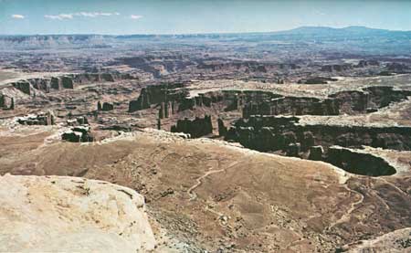
Let us now take the branch south of the Y and follow the narrow crest of Grand View Point for about 6 miles to the main overlook. About 0.9 mile south of the Y, a short walk to the west over the lower part of the Navajo Sandstone affords a magnificent view of Stillwater Canyon of the Green River, including Turks Head (figs. 23, 24). Half way to the point is a parking area and overlook, from which we get a spectacular view of canyons cutting the White Rim and of the La Sal Mountains beyond (fig. 20). Note that the White Rim Sandstone, which forms the broad bench appropriately named the White Rim, is here much thicker than where seen near Dead Horse Point (fig. 15).

|
| THE WHITE RIM, looking northeast toward La Sal Mountains from overlook 3 miles north of Grand View Point. White Rim Sandstone here is thicker than near Dead Horse Point (fig. 15) but thinner than in Monument Basin and Stillwater Canyon (figs. 21, 23). (Fig. 20) |
Three more miles southward takes us to Grand View Point and its nearby picnic area. Though named after the former Grand River some 2,000 feet below, Grand View Point has a double meaning, for we see from here a truly grand view (fig. 21)! At our feet is spectacular Monument Basin, cut below the White Rim into the brick-red Organ Rock Tongue of the Cutler Formation. The White Rim Sandstone here is slightly thicker than to the northeast (fig. 20) but thinner than to the west (fig. 23), because it forms a wedge-shaped body that thickens westward. In the distance southeastward are the Abajo Mountains, just west of Monticello, Utah. The prominent projection on Hatch Point on the left skyline is Needles Overlook, from which the photograph in figure 27 was taken. A closeup view of Monument Basin, showing Junction Butte and Grand View Point in the background, is shown in figure 22. The slender spire in the foreground has a measured height of 305 feet (Findley, 1971, p. 78).
|
| MONUMENT BASIN FROM GRAND VIEW POINT, Needles Overlook on left skyline, Abajo Mountains on right skyline. Red spires and cliffs in basin are Organ Rock Tongue of Cutler Formation. (Fig. 21) |

|
| MONUMENT BASIN FROM THE AIR, looking north to Junction Butte and Grand View Point. Spire of Organ Rock Tongue in foreground is 305 feet high. White top of Cedar Mesa Sandstone is at bottom of photograph. Photograph by National Park Service (Fig. 22) |
GREEN RIVER OVERLOOK
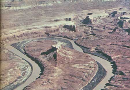
About a quarter mile west of the Y, a left fork of the road goes about a mile and a half to Green River Overlook, which provides a superb view of Stillwater Canyon of the Green River, the Orange Cliffs beyond, and the Henry Mountains in the extreme distance (fig. 23). Note that here the White Rim Sandstone is much thicker than in preceding views. The prominent butte enclosed by the loop of the river is known as Turks Head and is better seen from the air (fig. 24). The light-colored band near the base of the cliffs in the background of figure 24 is characteristic of the bleached upper part of the Moenkopi Formation in this part of the park. According to F. A. McKeown and P. P. Orkild (U.S. Geol. Survey, unpub. data, Feb. 16, 1973), petroliferous material or odor generally occurs in this bleached zone and in the basal beds of the Moenkopi.

|
| STILLWATER CANYON AND GREEN RIVER, looking southwest from Green River loop of river. Brown material covering nearby parts of the White Rim is lower part of Overlook. Orange Cliffs in background, Henry Mountains on right skyline. Turks Head in Moenkopi Formation. (Fig. 23) |
|
| TURKS HEAD, an erosional remnant of the White Rim Sandstone supported by red beds of Organ Rock Tongue, in loop of Green River. Aerial view looking north. Photograph by National Park Service. (Fig. 24) |
The campground just north of Green River Overlook has no water at this writing (1973), but water from wells in Taylor Canyon will eventually be piped to nearby parts of Island in the Sky.
UPHEAVAL DOME
Five miles northwest of the Y we come to Upheaval Dome, one of the most unusual geographic and geologic features of the park. Viewed from the air (fig. 25), it resembles somewhat a volcanic or meteor crater and has been called such by some. Because beds of salt are known to underlie the park, some have suggested that the salt may have thickened and welled upward to form a salt dome, similar to domes along the Gulf Coast (Mattox, 1968). However, only 1,470 feet of salt was encountered in an oil test just east of Upheaval Dome (Robert J. Hite, U.S. Geol. Survey, oral commun., Feb. 13, 1973); so although salt may have played a role, Upheaval Dome clearly is not a salt dome with dimensions similar to the Gulf Coast types. It may be related to a mound on the deep-seated Precambrian rocks (Joesting and Plouff, 1958, fig. 3; Joesting and others, 1966, p. 13, 14, 17), but the exact origin of the dome is not clear.

|
| UPHEAVAL DOME, aerial view looking northwest toward junction of Upheaval and Taylor Canyons with Labyrinth Canyon of Green River. Photograph by Walter Meayers Edwards, © 1971 National Geographic Society. (Fig. 25) |
The central part has the structure of a dome, in that the strata dip downward away from the middle. A ringlike syncline, or downward fold in the rock layers (fig. 26), surrounds the dome, beyond which the strata resume their nearly flat position. The white rock in the bottom of the craterlike depression is not salt, but jumbled large fragments of the White Rim Sandstone. Surrounding that are slopes of the Moenkopi and Chinle Formations, cliffs of the Wingate Sandstone, a circular bench of the Kayenta Formation, and outer ramparts of the Navajo Sandstone. Upheaval Canyon leads to Stillwater Canyon of the Green River at the upper left.

|
| CUTAWAY VIEW OF SYNCLINE, or downfold of the rocks. From Hansen (1969, p. 108). (Fig. 26) |
One mile before the road ends, a well-marked foot trail leads to the top of Whale Rock, a prominence on the Navajo Sandstone that forms the outer ring of the dome. At the end of the road, another foot trail ascends from the picnic area to the foot of the Wingate Sandstone cliffs around the central part of the dome. The views of the dome from these trails are interesting, but you are really too close to get a true picture of the unusual feature, which is obtainable only from the air, as shown in figure 25.
Just west of Upheaval Dome, Bighorn Mesa is connected to Steer Mesa by a neck only 15 feet wide flanked by 300-foot vertical cliffs, as pointed out by McKnight (1940, p. 12). I later learned from Ed McKnight (oral commun., June 6, 1973) that during his field work in this area in 1926 he was riding a mule across this narrow neck when the half-asleep mule suddenly became aware of the dropoff on one side and began to turn around and head back. Ed hastily but cautiously dismounted and led the mule across! When this neck is finally breached by erosion, Bighorn Mesa will be just as isolated and inaccessible as Junction Butte, now cut off from Grand View Point. (See frontispiece and fig. 27.)
Hatch Point
The high mesa east of Canyonlands National Park and the Colorado River canyons, called Hatch Point, contains several vantage points ideally suited for viewing scenic features of the park and adjacent areas. Hatch Point is part of the vast public domain administered by the Bureau of Land Management—a sister agency of the Geological Survey and the National Park Service, all in the U.S. Department of the Interior. The Bureau, hereinafter referred to simply as the B.L.M., has made many improvements on Hatch Point, including fine roads, two modern campgrounds with sanitary facilities and piped water from wells, and two overlooks with protective fences, benches, paths, sanitary facilities, and ramadas containing panels that describe the features visible from the viewpoints. Because of these improvements, the B.L.M. has appropriately named this area "Canyon Rims Recreation Area."
Geologically, Hatch Point is similar to Island in the Sky. Both are bordered by towering cliffs of the Wingate Sandstone capped by the resistant Kayenta Formation, and rounded remnants of the overlying Navajo Sandstone rise above the otherwise-flat mesa surface in many places.
Access to this high tableland is by a good paved road leading west from U.S. Highway 163 at a point 32 miles south of Moab and 22 miles north of Monticello. About 5 miles west of the highway we pass Windwhistle Campground, nestled in an attractive cove of Entrada Sandstone cliffs, and 16 miles from the highway we reach an intersection. From here it is 7 miles west by paved road to Needles Overlook, 10 miles north to Anticline Overlook. Like the other high mesas, Hatch Point contains peripheral areas of scattered piñon and juniper trees and large flat grasslands used for grazing. Grain tanks here and there store winter feed for the cattle.
NEEDLES OVERLOOK
Let us follow the pavement to Needles Overlook, from which fine morning views of Canyonlands National Park can be seen to the south and west. Northwestward (fig. 27) we look 10 miles across the Colorado River canyon to Junction Butte and Grand View Point. (This view is along the line of the east half of the cross section in fig. 10.) The feather edge of the White Rim Sandstone caps the White Rim west of the Colorado River, but the White Rim is absent on the east side of the canyon and in the entire Needles district to the southwest, where the important scenic features are carved from the underlying Cedar Mesa Sandstone Member of the Cutler Formation, referred to hereinafter simply as the Cedar Mesa Sandstone. Both these sandstones are missing in the foreground of figure 27—their place being taken by thin beds of red siltstone, mudstone, and sandstone similar to those that comprise the Organ Rock Tongue shown between the two sandstones in figure 22. These are additional examples of facies changes mentioned earlier (p. 34).

|
| JUNCTION BUTTE AND GRAND VIEW POINT, looking northwest from Needles Overlook. (Fig. 27) |
CANYONLANDS OVERLOOK
Turning north from the intersection 7 miles east of Needles Overlook, we traverse a nearly flat grassy tableland to Hatch Point Campground. In figure 1 the campground is shown west of the old road; the new road is west of the campground, but no map of the new route was available for plotting in figure 1. About a mile before we reach the campground a jeep trail heads west then northwest about 5-1/2 miles to Canyonlands Overlook, a scant mile from, but some 1,400 feet above, the eastern border of Canyonlands National Park. This overlook affords fine views of the Colorado River canyons and the eastern shore of Island in the Sky, but at present (1973) there are no plans to improve the trail for passenger-car travel.
Two miles north of the campground we cross a minor drainage leading northeastward into the north fork of Trough Springs Canyon. The B.L.M. plans a road down this canyon to Kane Springs Canyon, 1,100 feet below, where it will connect both with a scenic drive to Moab, the lower part of which is paved, and with the jeep trail going west over Hurrah Pass (fig. 30) and thence south along the eastern benches of the canyons of the Colorado River to the Needles district of the park. E. Neal Hinrichs (U.S. Geol. Survey, oral commun. Feb. 16, 1973) reported specimens of blue celestite (strontium sulfate, SrSO4) and barite (barium sulfate, BaSO4) in the Cutler Formation at a point where a sharp bend of this jeep trail crosses a fault, or fracture (fig. 56), in the northeast fork of Lockhart Canyon (shown in fig. 1 as the easternmost loop of the trail about 6 miles northeast of Lockhart Basin). Farther south, the trail swings west of Lockhart Basin, whose center exposes part of a syncline (fig. 28).

|
| SYNCLINE IN CORE OF LOCKHART BASIN, near Needles Overlook. Dish-shaped roof is Wingate Sandstone, partly bleached; sloping sides are Chinle Formation; dark sloping ledge at left middle ground is Moss Back Member of Chinle resting on Moenkopi Formation. Photograph by E. N. Hinrichs. (Fig. 28) |
U-3 LOOP
Two and a half miles farther north, or about 2 miles south of Anticline Overlook, a short road leads to the west and entirely around a small conical butte of the Navajo Sandstone. This new circular drive has not yet been formally named and is simply called the U-3 loop, as designated in the surveyor's notebook. It affords splendid views to the west and is to be equipped with picnic tables. Looking west (fig. 29) we see a W-shaped loop of the Colorado River, Dead Horse Point on the right skyline, and Island in the Sky on the distant skyline. The strata curving over Shafer dome appear in the right middle background.

|
| VIEW WESTWARD FROM U-3 LOOP. Dead Horse Point on right skyline, Island in the Sky capped by Navajo Sandstone in extreme distance, Kayenta Formation in foreground at left. Cliffs topping ridge at left are Wingate Sandstone protected by caprock of the Kayenta Formation; red slopes beneath cliffs are Chinle Formation, with dark ledge of Moss Back Member at base; steep slopes and ledges beneath are Moenkopi Formation, lower part of which is Hoskinnini Tongue; reddish gentle slopes below are Cutler Formation; nearly flat benches above Colorado River are Rico Formation, with Shafer limestone at top. (Fig. 29) |
ANTICLINE OVERLOOK
Two more miles takes us to Anticline Overlook for the most sublime views in this part of the area. To the north (fig. 30) we look across the northeast flank of the Cane Creek anticline, an upfold of the rocks (figs. 13, 14). Hurrah Pass straddles the narrow wall separating the Colorado River and its canyon at the left from Kane Springs Canyon on the right. The Colorado River appears again in the right background, where it leaves Moab Valley. The Kings Bottom syncline, or downfold (fig. 26), seen in the middle distance between the Cane Creek anticline and the Moab anticline, exposes a wide area of the Navajo Sandstone. The ridge on the right skyline, composed of the Entrada Sandstone, is The Windows Section of Arches National Park, and the left skyline shows faintly the distant Book Cliffs.
On the east wall of Kane Springs Canyon just to the right of figure 30 is the Atomic King mine in the Cutler Formation, from which uranium ore has been mined at intervals during the last 2 or 3 years.

|
| LOOKING NORTH FROM ANTICLINE OVERLOOK, across axis of Cane Creek anticline. Unimproved road crosses Hurrah Pass in foreground. Colorado River at left is near Potash and in right background is at Moab. For description of strata, see caption for figure 31. (Fig. 30) |
To the northwest (fig. 31; see also fig. 13) is a textbook example of a rock fold—the Cane Creek anticline—laid bare by the Colorado River cutting directly across its crest (fig. 1). Anticlines are noted as sources of or at least hunting grounds for oil and gas, and this one is no exception, although production has been relatively small and was stopped altogether in about 1963. Some oil and gas was produced also from wells on the north flank of Shafer dome, just beneath Dead Horse Point (figs. 1, 15), but other favorable-looking structures farther south that were tested, such as Lockhart anticline, Rustler dome, and Gibson dome (fig. 1), failed to yield commercial amounts (Baker, 1933, p. 80-84). Some of the colorful events in the early days of wildcatting are noted on page 100.
Exploration for oil and gas led to the discovery of potash beneath several anticlines in eastern Utah and western Colorado. According to Hite (1968, p. 325), the Cane Creek anticline is underlain by about 5,200 feet of salt-bearing rocks in the Paradox Member of the Hermosa Formation (fig. 9), of which about 84 percent is halite (common salt, sodium chloride) and associated potash salts (sylvite, potassium chloride). The potash mine of Texas Gulf, Inc., is shown at the right in figure 31 The white area to the left of the mine is waste common salt, which is recovered with the potash salts, and the white area with dark stripes at the left is a small part of more than 400 acres of evaporation ponds built to separate the salts. These ponds also can be seen from Dead Horse Point. The dark stripes are the visible parts of plastic membranes lining the ponds. Mining of an 11-foot bed of ore began by usual underground methods from the bottom of a shaft 2,788 feet deep but became too difficult because of intense and intricate folding of the salt beds. Now the salts are being extracted by a method involving solution, wherein river water is introduced into the former workings and allowed to stand long enough to dissolve the salts, then the brine is pumped out to evaporation ponds, and the valuable potash salts are separated from the sodium salts. Closeup views of the mine and evaporation ponds are seen in figures 70 and 71.

|
| CANE CREEK ANTICLINE, looking northwest from Anticline Overlook. Colorado River is cutting into limestone of unnamed upper member of Hermosa Formation in lower bench at crest of fold; Rico Formation, with bluish-white Shafer limestone at top, forms upper curved bench; remainder of formations are as given in caption for figure 29. Potash mine (right) and evaporation ponds (left) are operated by Texas Gulf, Inc. Merrimac and Monitor Buttes on right skyline are shown in figure 12. (Fig. 31) |
As noted earlier, most of the readily recognizable thin beds, such as the White Rim Sandstone, pinch out south of here, and figure 31 marks the northeasternmost exposure of the Shafer limestone at the top of the Rico Formation. Northeast from here the Rico and overlying Cutler Formation are not readily separable and are included in the so-called Cutler Formation undifferentiated. This land-laid unit of red sandstone, siltstone, and shale is as much as 8,000 feet thick just southwest of the ancient Uncompahgre highland (present Uncompahgre Plateau, in western Colorado and eastern Utah), from which it was derived by erosion during the Permian Period (fig. 80).
Orange Cliffs
The high mesas west of Canyonlands National Park do not form as distinct a mainland as does Hatch Point, but rather are broken up into a maze of peninsulas and islands, as shown in figure 1. Owing to the gentle northwestward dip of the rock strata, the altitude of the mesas declines from about 7,000 feet in the south to about 5,300 feet in the north and northwest, where the whole aspect of the country becomes more rounded and subdued. As shown on the map (fig. 1), however, the name Orange Cliffs is applied to much of the eastward-facing cliffs, which are made of the Wingate Sandstone capped by the Kayenta Formation. Remnants of the Navajo Sandstone increase in number to the north and west, where remnants of the next two younger rock units—the Carmel Formation and the Entrada Sandstone—also occur. Thus, the cliff-forming units dip downward beneath younger rocks that form the relatively flat Green River Desert to the northwest, also referred to as the San Rafael Desert. Figure 32 is a view southeastward from The Spur, shown on the map (fig. 1) as the northern section of the Orange Cliffs.

|
| VIEW SOUTHEASTWARD FROM THE SPUR, in northern section of Orange Cliffs. Junction Butte and Grand View Point on left skyline; Abajo Mountains in extreme distance to right of center. Photograph by Parker Hamilton, Flagstaff, Ariz. (Fig. 32) |
At present (1973), the areas west of the Green River and the main stem of the Colorado River are the least accessible of any in the park and in this respect have not changed much since Butch Cassidy and his Wild Bunch roamed the area, except that the former main horse trails are now jeep trails. A secondary road south from the town of Green River goes past the north side of the Horseshoe Canyon Detached Unit (figs. 1, 2) and connects with another secondary road to the west, which joins Utah Highway 24 at Temple Junction, 20 miles north of Hanksville; near Horseshoe Canyon a jeep trail leads south to the Orange Cliffs. Owing to blowing sand, these "roads" are not considered reliable for passenger cars and are best negotiated by four wheel-drive vehicles or horses.
According to Baker (1971, p. 12), the road leading eastward along North Point was used by the Wild Bunch in traveling to French Spring, whence they dropped down Millard Canyon (fig. 33) and crossed the Green River at Bonita Bend, which is just east of Buttes of the Cross (fig. 64). They also followed the Old Spanish Trail from the Henry Mountains eastward across the Dirty Devil River, up North Hatch Canyon, across Sunset Pass, and down across the Land of Standing Rocks to Spanish Bottom on the Colorado River (fig. 1). After crossing the river, they followed the trail up Lower Red Lake Canyon (fig. 59) and eastward through The Needles to Monticello.

|
| LOOKING NORTH DOWN MILLARD CANYON from head of canyon a mile northwest of French Spring. Note small arch or window in the Navajo Sandstone at upper left, which is shown in figure 1 as "Arch." The Navajo is underlain by the cliff-forming Kayenta Formation and Wingate Sandstone resting upon a sloping base of the Chinle Formation and, farther downstream, ledges and slopes of the Moenkopi Formation. Photograph by Parker Hamilton, Flagstaff, Ariz. (Fig. 33) |
| <<< Previous | <<< Contents >>> | Next >>> |
bul/1327/sec7.htm
Last Updated: 28-Dec-2006