
|
Geological Survey Bulletin 1327
The Geologic Story of Canyonlands National Park |
THE BENCHLANDS

The White Rim, a broad benchland some 1,000-1,200 feet below the southern half of Island in the Sky, and some of the associated benchlands west of the Green River and between the Colorado River and Hatch Point have already been discussed as viewed from Island in the Sky, the White Rim Trail, or Hatch Point. There remain for consideration several other prominent benchlands.
The Maze and Land of Standing Rocks
The Maze, an intricately carved series of canyons and gullies, has been called a "Thirty-square-mile puzzle in sandstone" (Findley, 1971, p. 71-73), and one can readily visualize a king sized rat struggling in vain to find a way out. The rock is the Cedar Mesa Sandstone, which here underlies red shales beneath the White Rim Sandstone. South of The Maze an area containing tall spires was appropriately named by the Indians "Toom'-pin wu-near' Tu-weap'," or "Land of Standing Rocks" (Powell, 1875, p. 154).
West of The Maze is Elaterite Basin, so named because of a dark-brown elastic mineral resin called elaterite, which seeps from the White Rim Sandstone. One of these seeps is shown in figure 34, and a wedge-shaped layer of the sandstone is shown in figure 35. In the Range Canyon area shown in figure 35, sand was being laid down in an offshore bar at the left, while red silts and muds were being deposited on land to the right. The dark bed just above the White Rim near the middle of the photograph is the Hoskinnini Tongue of the Moenkopi Formation, which intertongues with and pinches out in beds of the Moenkopi Formation to left. These are excellent examples of what geologists call facies changes.

|
| ELATERITE STEEPING FROM WHITE RIM SANDSTONE in Elaterite Basin west of The Maze. Elaterite is a dark-brown elastic mineral resin. Photograph by Donald L. Baars. (Fig. 34) |

|
| WHITE RIM SANDSTONE in north wall of Range Canyon, south of Elaterite Basin. Bed thins from 230 feet at left (west) to 38 feet at right (east), and disappears (by facies change into red shales) a short distance farther east. See description in text of pinch out of Hoskinnini Tongue. Bed at top of mesa is Moss Back Member of Chinle Formation. Photograph by Donald L. Baars. (Fig. 35) |
South of the Land of Standing Rocks are equally colorful areas known as The Fins and Ernies Country (named after Ernie Larson, an early-day sheep man). A prominent row of spires near Cataract Canyon is known as The Doll House (fig. 36).

|
| THE DOLL HOUSE, eroded from Cedar Mesa Sandstone just west of Spanish Bottom, above Cataract Canyon. Notice the red layer at right offset by a fault. Photograph by Parker Hamilton, Flagstaff, Ariz. (Fig. 36) |
The Needles district
The Needles district is currently (1973) the most highly developed part of the unfinished park as the result of design, not accident, for this district includes the greatest number and widest variety of spectacular features—The Needles proper, The Grabens (pronounced gräbens), colossal arches and other erosional forms, large meadows such as Squaw Flat and Chesler and Virginia Parks, a wide variety of prehistoric ruins and pictographs, and Confluence Overlook for viewing the joining of two mighty rivers—the Green and the Colorado. Like the White Rim and The Maze, the Needles district is another of the broad benchlands about midway between the high mesas and the deep canyons.
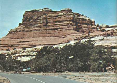
Utah Highway 211, as mentioned already, is a 38-mile-long paved road leading to the Needles district from U.S. Highway 163 at a point 15 miles north of Monticello and 18 miles south of La Sal Junction. The intersection is well marked by Church Rock (fig. 37), a butte of the Entrada Sandstone. Highway 211 gradually climbs an eastward-dipping slope of the Navajo Sandstone dotted with a few buttes and patches of the Entrada Sandstone, such as Church Rock, and reaches the first of two summits 3 miles west of Highway 163. The road crosses a broad gentle valley in the Navajo Sandstone, reaches the second summit about 10 miles from the highway, then descends steeply through the Navajo Sandstone and part of the Kayenta Formation to Indian Creek, 1-1/2 miles below, and follows this creek nearly to The Needles. Half a mile down the canyon takes us to the top of the cliff-forming Wingate Sandstone, and another half mile brings us to Indian Creek State Park and its striking Newspaper Rock (fig. 5). Another 1-3/4 miles takes us to the base of the Wingate and top of the underlying Chinle Formation, which forms the red slope beneath the cliffs.

|
| CHURCH ROCK, standing guard at the intersection of U.S. Highway 163 and the east end of Utah Highway 211 leading to the Needles district. Rock is Entrada Sandstone: red foundation is Dewey Bridge Member; yellowish smooth rounded body of church is Slick Rock Member; white steeple is Moab Member. La Sal Mountains at left. (Fig. 37) |
Historic Dugout Ranch (p. 14) is 19 miles west of the highway, and from here a dry-weather road leads southward up north Cottonwood Creek 37 miles to Beef Basin and connects with roads to Elk Ridge and the Bears Ears, both just west of the Abajo Mountains. Just west of the ranch we get a good view ahead of two historic landmarks—North and South Six-Shooter Peaks (fig. 38), so named because of their resemblance to a pair of revolvers pointing skyward. The guns are sculptured from slivers of Wingate Sandstone resting upon conical mounds of the Chinle. These can be seen from a wide area; both appear in figures 38 and 40, and the north one is seen in figure 77.

|
| NORTH AND SOUTH SIX-SHOOTER PEAKS, looking west from entrance road to The Needles. (Fig. 38) |
A mile west of Dugout Ranch we descend to the top of the Moss Back Member of the Chinle, a ledge of gray-green sandstone forming the base of this generally red formation, and reach the base of the member at the top of the Moenkopi Formation in the next mile and a half. The Moss Back is uranium bearing in nearby areas.
At 3.8 miles west of Dugout Ranch a poorly marked road on the left crosses Indian Creek, then forks; the left-hand fork follows the bed of Lavender Canyon, and the right-hand fork goes into Davis Canyon. Headwaters of both these canyons are new additions to the park.
The red Organ Rock Tongue of the Cutler Formation is seen about 3 miles beyond the turnoff, or about 6 miles west of Dugout Ranch. Another 1-1/2 miles takes us down in the rock column (fig. 9) to the top of the Cedar Mesa Sandstone. The White Rim Sandstone, which forms such a prominent bench around the southern part of Island in the Sky (figs. 20-23) and west of the Green River, is missing from the Needles district, its place in the rock column being taken by red shales and sandstones of the Cutler Formation. South of Indian Creek other underlying red beds of the Cutler are gradually replaced in turn by the thick Cedar Mesa Sandstone. Erosion has reduced the general level of the Needles district to or into the Cedar Mesa Sandstone, but many streams have cut into the underlying Rico Formation, and the Colorado River has cut also into, and in places through, the limestones of the unnamed upper member of the Hermosa Formation. Our first view of The Needles is another 4 miles, and 1 more mile takes us to the park boundary, nearly 32 miles from the U.S. Highway 163. We pass a road on the right leading to Canyonlands Resort, and on the left is a new line camp which replaces the restored one at Cave Spring (fig. 6).
The unusual features of the Needles district are due in some part to the character and thickness of the underlying rocks but in large part to erosion along joints and faults. Joints are fractures along which no displacement has taken place, and faults are fractures along which there has been displacement of the two sides relative to one another (fig. 76). The Cedar Mesa Sandstone comprises 500 to 600 feet or more of hard well-cemented buff, white, and pink beds of massive sandstone. On the basis of the type and amount of deformation and erosion of the Cedar Mesa Sandstone and underlying rocks, the Needles district can be divided into three differing areas: (1) an eastern area where the rocks are relatively undeformed but are carved into an intricate series of canyons, including Salt Canyon and the upper reaches of Davis and Lavender Canyons—the section of the district that contains most of the arches and Indian ruins; (2) The Needles proper, where tensional forces have cracked the brittle Cedar Mesa Sandstone into a crazy-quilt pattern of square to rectangular blocks separated by joints widened by erosion, creating a myriad of spires and pinnacles; and (3) The Grabens, where the previously jointed rocks were later subjected to additional tensional forces that produced a series of nearly parallel faults that trend northeastward and separate downdropped blocks of rock, called grabens, from intervening stationary or upthrown blocks of rock, called horsts.
Let us examine each of these areas in the order named. For traveling to most features a four-wheel-drive vehicle is strongly recommended. Some visitors negotiate the jeep trails with dune buggies or motorcycles, but four-wheel-drive vehicles are considered safer and generally more reliable. A few trails can be traveled only on foot.
Squaw Flat, in the western part of the relatively undeformed area, is a nearly flat area of lower Cedar Mesa Sandstone covered here and there by a thin layer of sparsely vegetated soil and surrounded by generally low hilly erosional forms in the upper part of the sandstone. Short canyons and alcoves in the sandstone hills along the west side afford excellent semi-private campsites, each of which has its own paved access road, picnic table, and trash can (fig. 39). Moreover, ground water at shallow depth in the underlying sandstone has encouraged the growth of exceptionally large piñon and juniper trees that provide welcome shade.
|
| SQUAW FLAT CAMPGROUND, in the Needles district, in Cedar Mesa Sandstone. Large piñon and juniper trees draw ground water from this sandstone. (Fig. 39) |
SALT, DAVIS, AND LAVENDER CANYONS
A glance at the southeast corner of the map (fig. 1) shows that most of the arches and prehistoric ruins in the park are in Salt Canyon and its main tributary, Horse Canyon. A few are in adjacent Davis and Lavender Canyons, whose headwaters were recently annexed to the park. These canyons are accessible only by negotiating the streambeds on four-wheel-drive vehicles, horseback, or foot. Salt or Horse Canyons are best conquered by four-wheel-drive vehicles plus short hikes in the northern part and long hikes in the southern part.
An aerial view (fig. 40) eastward across Salt Canyon shows that erosion has produced an intricate series of meandering canyons separated by rather narrow walls of the Cedar Mesa Sandstone, resembling somewhat The Maze, west of the Green River.

|
| AERIAL VIEW EASTWARD ACROSS SALT CANYON. Note narrow walls and pinnacles between canyons and alcoves. Six-Shooter Peaks are in left background. Photograph by Wayne Alcorn, National Park Service. (Fig. 40) |
The massive sandstone beds of the Cedar Mesa are composed of sand grains cemented together by calcium carbonate (CaCO3), which also forms the mineral called calcite and the rock known as limestone. Limestone and calcite are soluble in acid, even weak acid such as carbonic acid (H·HCO3), formed by solution of carbon dioxide (CO2) in water. Ground water, found everywhere in rock openings at differing depths beneath the surface, contains considerable dissolved carbon dioxide derived from decaying organic matter in soil, from the atmosphere, and from other sources. Even rain water and snow contain small amounts absorbed from the atmosphere—enough to dissolve small amounts of limestone or of calcite cement in sandstone. The calcite cement in the Cedar Mesa and many other sandstones is unevenly distributed, so the cement is removed first from places that contain the least amounts, and once the cement is dissolved, the loose sand grains are carried away by gravity, wind, or water. Thus, relatively thin walls of sandstone containing irregularly distributed patches of soluble cement are prime targets for the formation of potholes (fig. 46), alcoves, and caves. Once a breakthrough occurs, weakened chunks from the ceiling tend to fall off, and arches of various shapes are produced, because an arch is naturally the strongest form that can support the overlying rock load. Man, from the ancient Greeks, Romans, and Egyptians to modern day, has long made use of arches in building bridges, aqueducts, temples, cathedrals, and other enduring edifices. All the spectacular arches we are about to see were carved from the Cedar Mesa Sandstone.
Let us begin our tour of Salt and Horse Canyons by driving a four-wheel-drive vehicle eastward from the fine campground at Squaw Flat. After about a mile we pass the Wooden Shoe (fig. 41) capping a ridge south of the highway; it contains one of the smallest arches we will encounter. Three quarters of a mile east of the temporary ranger station we come to Cave Spring, an old restored cowboy line camp pictured in figure 6. This and an adjacent cave containing a spring are part of the interesting well-marked Environmental Trail, well worth the half hour or so it requires.

|
| WOODEN SHOE, near temporary ranger headquarters, the Needles district. Carved in Cedar Mesa Sandstone. (Fig. 41) |
The jeep trail up Salt Canyon lies mostly in the sandy bed of Salt Creek but includes a few shortcuts across goosenecks and some rough rocky stretches around rapids or waterfalls. It is best traveled when the canyon bottom is moist but not soaked. When the sand is soft and dry, a shift into four-wheel drive is generally necessary. Signs warn of quicksand, which occurs when the sand is fully saturated; hence, summer thunder showers sometimes require delaying or postponing the trip. When in doubt, consult a park ranger for expected weather and trail conditions. Thundershowers sometimes occur so suddenly and violently as to cause serious floods, and the "road" is closed when heavy rain is expected. However, if an unexpected storm occurs while you are up in the canyon, try to reach high ground and wait until the flood subsides. If you do not have time to get your vehicle out of the flood's path, at least get yourself and passengers to a safe spot.
Two and a half miles south of Cave Spring we reach the confluence with Horse Canyon, marked by a sign at the Y giving distances to points of interest up each canyon. Let us try Horse Canyon first. After about a mile we pass Paul Bunyans Potty on the left—one of the most aptly titled features of the park (fig. 42). Two miles south of the Y is Keyhole Ruin, nestled in a cleft high on the cliff to our left—a granary built by the Anasazi. Here we face another Y. The left fork leads half a mile east to Tower Ruin (fig. 4), one of the largest and best preserved Anasazi granaries in the park. The right fork takes us on up Horse Canyon, and in about 2 miles we pass Gothic Arch on the right. In 2 more miles, 4 miles from Salt Canyon, a short hike up the tributary to the right leads to Castle Arch and Thirteen Faces. Assuming we have taken photographs of the important features along the way, it probably is about time to return to camp at Squaw Flat, unless we choose to spend the night at Peek-a-boo Spring and primitive campground in Salt Canyon, about 1.2 miles above the confluence with Horse Canyon.

|
| PAUL BUNYANS POTTY, on east wall of Horse Canyon. (Fig. 42) |
Another drive takes us up Salt Canyon 8-1/2 miles past the confluence with Horse Canyon to another confluence and Y, which has a primitive campsite without water. One mile up the left, or southeast, tributary is a parking area where we begin the 1/2-mile walk to Angel Arch, considered by many people to be the most beautiful and spectacular arch in the park if not in the entire canyon country. Angel Arch was drawn for the front cover by John R. Stacy and is pictured in figure 43.

|
| ANGEL ARCH, along tributary of Salt Canyon. (Fig. 43) |
From the last Y we can proceed only about 2-1/2 miles farther up main Salt Canyon by vehicle, and the remaining features shown on the map (fig. 1) can be reached only on foot. The All American Man, a unique pictograph referred to earlier (fig. 3), is about 3-1/2 miles up the canyon. Those hardy souls who wish to hike many additional miles to the head of Salt Canyon will be rewarded with views of four additional arches and several ruins. Two of these arches are shown in figures 44 and 45.

|
| FISHEYE ARCH, along upper Salt Canyon, looking north. Photograph by National Park Service. (Fig. 44) |

|
| WEDDING RING ARCH, along upper Salt Canyon. Photograph by National Park Service. (Fig. 45) |
The more adventuresome may wish to explore upper Lavender and Davis Canyons by driving up the sand washes in a four-wheel-drive vehicle, but inquiry should be made from a park ranger regarding access to the canyon mouths and condition of the washes. Hand Holt Arch (fig. 46) and Cleft Arch (fig. 47) are two of the rewarding sights in Lavender Canyon, and figure 48 shows one of the arches in Davis Canon.

|
| HAND HOLT ARCH, in Lavender Canyon. Note holes in sandstone formed by solution and wind scour. Photograph by National Park Service. (Fig. 46) |

|
| CLEFT ARCH, in upper Lavender Canyon, looking north. Photograph by E. N. Hinrichs. (Fig. 47) |

|
| ARCH, in upper Davis Canyon, looking northwest. Photograph by E. N. Hinrichs. (Fig. 48) |
THE NEEDLES AND THE GRABENS
The northeastern edge of The Needles proper can be seen from Squaw Flat (fig. 49), but the true character of The Needles can be appreciated better from the air (fig. 50). You cannot get far into The Needles without traversing part of The Grabens, so we will consider them together. An aerial oblique view (fig. 51) shows The Needles in the foreground and The Grabens in the middle background. As shown on the map (fig. 1), you can hike into The Needles and The Grabens from Squaw Flat, but let us make the trip using a four-wheel-drive vehicle and several short hikes.

|
| THE NEEDLES, looking southwest from Squaw Flat. (Fig. 49) |

|
| CHESLER PARK IN THE NEEDLES, aerial view looking northeast. Photograph by Walter Meayers Edwards, ©1971 National Geographic Society. (Fig. 50) |
Ordinary passenger cars now can go 2-3/4 miles west of Squaw Flat to Soda Spring, at the east base of Elephant Hill, but beyond Soda Spring four-wheel-drive vehicles should be used. Some people conquer the hill in dune buggies or on motorcycles, but this is considered quite dangerous. Both sides of this short (1-1/4 miles) but formidable hill have switchback curves too sharp to negotiate in the regular manner, so special driving techniques must be followed. On the east side, you must drive out on a flat rock, jockey back and forth until turned completely around, then proceed up the hill. On the west side, you descend a 40-percent grade to a shelf, back down a narrow stretch of about 30-percent grade and back sharply to the left onto a flat rock, then go forward again. On the return trip the whole procedure is carried out in reverse order.
West of Elephant Hill, the road reaches a Y, at which you must turn left on a one-way road; the right-hand road is for later one-way return to the Y. Why the left-hand fork is one way soon becomes apparent, for the road leads into a narrow shallow graben, called Devils Pocket (fig. 51), between rock walls, and is barely wide enough for one car. After about 2 miles the graben widens out into a beautiful spot called the Devils Kitchen, which contains several picnic tables tucked into shady recesses in the sandstone walls. This is the starting point for two trails leading southward by different routes to Chesler Park, from which other trails lead to Druid Arch or back to Squaw Flat.
From the Devils Kitchen, the road turns abruptly westward for about half a mile to another Y in about the middle of Devils Lane, one of the larger grabens and one of two whose entire length is traversed by roads, as shown on the map (fig. 1). Only the left fork is a two-way road, so let us take the left fork 2-3/4 miles southwestward to the next road junction. About halfway down Devils Lane, a fault crossing the graben has created a narrow steep ridge appropriately called SOB Hill, because the road over it creates a challenge that some vehicles fail to meet on the first attempt!
The next road intersection is now shown on the map (fig. 1) as a sharp turn leading southwest to Ruin Park and Beef Basin. The abandoned left fork (not shown) leads east into Chesler Park. This park, shown in figure 50 and near the bottom of figure 51, is a beautiful natural meadow of several hundred acres fenced by a natural wall of needles and containing a central island of needles. Because of vehicular damage to meadow vegetation, the National Park Service found it necessary to close the road. To reach Chesler Park now, vehicles must go right a short distance to the Chesler Canyon turnoff, then left about half a mile to a parking area. From here, a 1/2-mile hike east through the narrow Joint Trail gets us to the south side of Chesler Park, where we join the abandoned road to reach the northeast corner of the park and the trails into The Needles proper (fig. 1).

|
| THE NEEDLES AND THE GRABENS, aerial oblique view looking west over Chesler Park in foreground, The Grabens to the right, and Cataract Canyon behind. Photograph by U.S. Army Air Force. (Fig. 51) |
This change adds 1-3/4 miles (one way) to the hike to Druid Arch, making the round trip about 11-1/2 miles. At the old trailhead, near the northeast corner of Chesler Park, is a sign proclaiming the need for rubber-soled shoes and water, and I strongly support these admonitions, for much of the hike is on bare smooth sandstone and includes steep slopes and generally dry waterfalls. The hike should not be attempted by anyone not in good physical condition, and it should not be undertaken alone; two or more people should travel together.
As shown in figure 52, the trail to Druid Arch from Chesler Park starts out on bare Cedar Mesa Sandstone marked by a succession of rock cairns, two of which are visible and without which the trail would soon be lost. The trail drops rapidly down into Elephant Canyon, which is then followed southward 2 miles to the arch. This canyon has cut through the Cedar Mesa into the underlying Rico Formation, and much of the canyon is quite narrow and steep sided, as shown in figure 53. Although much of the Rico consists of red beds laid down above sea level by ancient streams, the trail crosses several thin beds of dark-gray hard limestone containing fossil marine seashells and ancient sea anemones whose original calcium carbonate parts have been locally replaced by jasper (red iron-bearing silica). When at last the weary hiker makes the steep climb out of the canyon and rounds the final bare-rock curve, the sudden and striking view of Druid Arch (fig. 54) seems worth every bit of the effort—at least it was to me and my hiking companion.

|
| TRAIL TO DRUID ARCH, near its beginning at northeast corner of Chesler Park, marked only by rock cairns, two of which are visible. (Fig. 52) |

|
| UPPER ELEPHANT CANYON, containing trail to Druid Arch. (Fig. 53) |

|
| DRUID ARCH, from end of arduous trail shown in figures 52 and 53. (Fig. 54) |
After my friend and I hiked to Druid Arch and after the length of this route was increased to a round-trip distance of 11-1/2 miles, a new route was constructed having a round-trip length of only 8-1/2 miles. This new trail starts at the end of the passenger-car road at the east edge of Elephant Hill, goes 1-1/4 miles southwest to join an older trail in Elephant Canyon, then follows this canyon 3 miles south to the arch.
After returning to our vehicle west of Chesler Park and backtracking over SOB Hill to the intersection in the middle of Devils Lane, let us proceed northward on a one-way road to and beyond the Silver Stairs for a closer look at Devils Lane and other grabens to the west and for a look at the confluence of the Green and Colorado Rivers. But first let us pause and reflect upon the possible origin of The Grabens.
Geologists have different opinions as to just how grabens and complex systems of joints have formed, but all seem to agree that tensional forces were involved. Some think that solution of salt and gypsum from the Paradox Member of the Hermosa Formation by ground-water movement allowed the brittle Cedar Mesa Sandstone and other overlying rocks to sag, producing tension cracks and faults. Others believe that removal of the salt and gypsum occurred by plastic flowage toward the Meander anticline (see p. 108 and fig. 61), whose axis follows the Colorado River southwest from The Loop, past the confluence, and to and beyond Spanish Bottom. Some suppose that compaction due to the weight of the abnormally thick pile of sedimentary rock underlying the area may have caused the sagging, cracking, and faulting. The rock deformation may have resulted from a combination of these and possibly other things, of course, but whatever the cause, the resulting features are very striking. There was room to show only two of the named grabens within the park on the map (fig. 1), but all are shown in figure 51, and several appear in figure 59. A diagramatic cross section of a typical graben is shown in figure 55. The tension faults shown in figures 55 and 56 are called normal faults, in contrast to faults formed by horizontal compression, which are called reverse faults (figs. 75, 76).

|
| A SIMPLE GRABEN, formed by tension in directions indicated by horizontal arrows. Downdropped central block is the graben; stationary or uplifted blocks on sides are called horsts. From Hansen (1969, p. 123). See also figure 76. (Fig. 55) |

|
| CUTAWAY VIEW OF NORMAL FAULT, resulting from tension in and lengthening of the earth's crust Note amount of displacement and repetition of strata. Compare with figure 76. From Hansen (1969, p. 116). (Fig. 56) |
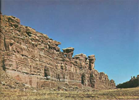
The Grabens range in width from about 7 or 8 feet at the north end of Devils Pocket to nearly 2,000 feet at the south end of Red Lake Canyon, but the average width is about 500 feet. The floors of The Grabens are covered by soil and grass, but the displacement along the faults is believed to approximate the height of the walls—nearly 300 feet. That The Grabens are of fairly recent origin is attested by the fact that most of the walls are vertical fault faces showing little sign of erosion (fig. 57); that no through drainage has yet been established in Cyclone Canyon, which is a series of basins with low divides between; and that several pre-existing streams were interrupted or diverted by the faulting.
|
| WEST WALL OF CYCLONE CANYON GRABEN, a nearly vertical fault face showing little sign of erosion. (Fig. 57) |
Now let us continue our journey northward along Devils Lane. Just before reaching the Silver Stairs we may wish to pause long enough to take in the distant view to the northwest toward Junction Butte and Grand View Point. (See frontispiece.) After descending the steep Silver Stairs in a narrow cleft between rock walls, we reach another intersection: a two-way road continuing northwest goes to our destination, and a one-way road turning right returns to Elephant Hill via part of Elephant Canyon (fig. 58).

|
| LOWER ELEPHANT CANYON, followed by jeep trail from near Silver Stairs to Elephant Hill. (Fig. 58) |
About 2 miles to the northwest we cross the north end of Cyclone Canyon, the largest graben. It contains a road 3-1/2 miles long and is well worth seeing. About one-half mile from the south end, an old trail follows Red Lake and Lower Red Lake Canyons to the Colorado River across from Spanish Bottom (figs. 1, 61).
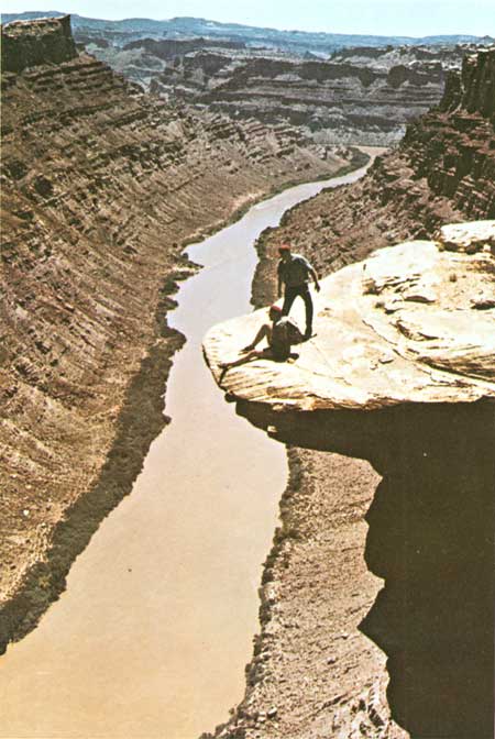
From near the north end of Cyclone Canyon (figs. 1, 59), we drive west three-fourths mile to a parking area and hike one-half mile to an overlook for a spectacular view of the confluence of the Green and Colorado Rivers (figs. 59, 60) and of the northern part of Cataract Canyon (fig. 61). These and other canyons are discussed in the next chapter.

|
| THE CONFLUENCE FROM THE AIR, and some of The Grabens. See also figure 51. Vertical aerial photograph by U.S. Geological Survey. (Fig. 59) |

|
| THE CONFLUENCE FROM CONFLUENCE OVERLOOK, shown in figures 1 and 59. Green River entering from left, Colorado River from right. Red beds near top are Rico Formation, overlain by Cedar Mesa Sandstone and underlain by unnamed upper member of Hermosa Formation (Fig. 60) |
|
| CATARACT CANYON, from the rim, looking south to Spanish Bottom at bend. Beds dip to left and right away from Colorado River, which here is followed by axis of Meander anticline. (See p. 108). Cliff below overhanging rock resembles profile of a man; the rock resembles his hat. Photograph by Walter Meayers Edwards, ©1971 National Geographic Society. (Fig. 61) |
| <<< Previous | <<< Contents >>> | Next >>> |
bul/1327/sec8.htm
Last Updated: 28-Dec-2006