|
Geological Survey Bulletin 613
Guidebook of the Western United States: Part C. The Santa Fe Route |
ITINERARY
HOLLIDAY TO EMPORIA BY WAY OF OTTAWA.1
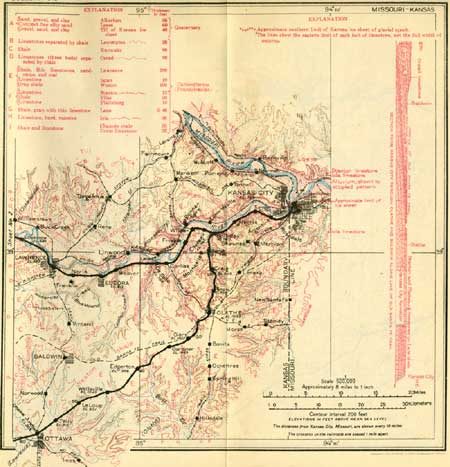
Some of the trains on the Santa Fe Route now diverge from the old line at Holliday and take a more direct line nearly straight southwest by the Ottawa cut-off. This line runs over the plateau between Kansas and Osage rivers, then up the valley of the latter for some distance, and finally across the low but wide divide to Neosho River. On this line the railway crosses wide areas of shale and gradually rises from one limestone ledge to another in the great succession of rocks of later Carboniferous age that constitute the surface of eastern Kansas. The outcrops of these limestones extend from southwest to northeast across the country in lines of low cliffs, above some of which are bare rocky slopes of varying width. As the beds dip to the west, each bed of limestone passes in succession beneath the overlying so that the beds which crop out in the bluffs near Kansas City shale, lie several hundred feet below the surface at Emporia. These relations are shown in the cross section on sheet 1 (p. 14). On the other hand, the upper beds of limestone and shale, which crop out at the surface in the western part of the area, originally extended far to the east, but they have been removed by erosion down to the general level of the country.
1The mileposts on this line indicate distance from Kansas City.

|
|
SHEET No. 1 (click on image for an enlargement in a new window) |
There is a vast quantity of limestone in this region, part of it in beds too thin to be useful, but some of it in thick deposits and consisting of nearly pure calcium carbonate. This rock is utilized at Iola, Independence, and other places in Kansas and elsewhere for the manufacture of Portland cement.1
1Cement is made by burning a mixture of ground limestone and shale and grinding the resulting clinker to a very fine powder. In some places clay or loam is used instead of shale. Some limestones contain naturally a suitable admixture of the clay element for the manufacture of hydraulic cements, but the term Portland is generally applied only to cements produced by burning an artificial mixture, as described. Many of the thick beds of limestone exposed from Kansas City westward could be utilized for cement manufacture, but at present there would be difficulty in competing with the southern Kansas product owing to the advantage afforded by a natural-gas fuel supply to the plants located farther south. Moreover, the cement market appears to be amply supplied by plants now in operation at many places in the United States. The shale in the region from Kansas City westward could be utilized more extensively for tile, brick, and other similar products if fuel were cheaper or if the local demand were sufficient.
On leaving Holliday, the train ascends the valley of Mill Creek to its head at Olathe, a distance of 12-1/2 miles and a rise of about 260 feet. This valley is excavated in the beds that constitute the bluffs at Kansas City and Argentine. Several beds of shale are exposed, and many ledges of limestone extend along the valley sides.
|
Olathe. Elevation 1,023 feet. Population 3,272. Kansas City 26 miles. |
Olathe (o-lay'the, th as in thin; Shawnee for beautiful) is on the summit of the plateau which is traversed by the railway for many miles toward the southwest. This plateau is mostly covered by shale. At long intervals the railway descends into shallow valleys, most of them exposing ledges of underlying limestones.
At Olathe the railway crosses the line of the Santa Fe Trail, which is described in the footnote on pages 17-18.
|
Gardner. Elevation 1,065 feet. Population 514. Kansas City 34 miles. Edgerton. Elevation 966 feet. Population 443. Kansas City 40 miles. Wellsville. Elevation 1,043 feet. Population 648. Kansas City 46 miles. Ottawa Junction. Elevation 915 feet. Kansas City 57 miles. |
The trail lies a short distance north of the railway from Olathe through Gardner and Edgerton, but near Edgerton it diverges toward the west, going through Baldwin, which was formerly the well-known Palmyra stage station. A short distance west of Wellsville the railway track crosses a thin ledge of limestone and enters a broad area of shale. At Ottawa Junction (North Ottawa) the main line is crossed by a branch of the Santa Fe system which extends from Lawrence southward to Tulsa, Okla. A mile south of the junction is the town of Ottawa, which has a population of 7,650 and is the county seat of Franklin County. Ottawa is a locally important center and has several manufactories, most of them operated by water power from Osage River, which passes through the town. In borings at this place natural gas is obtained from sandstone at depths of 435, 665, 803, and 1,060 feet, Some years ago the skeleton of a mammoth was dug up on Main Street in Ottawa, and remains of others have been found in the vicinity. These large animals, which were closely similar in form to the elephant, were abundant in the United States thousands of years ago, together with various other species long extinct. A restoration of the principal variety of mammoth is shown in Plate II, B (p. 18). At Ottawa Junction, just south of the railway, is a factory where tiles, brick, etc., are manufactured from shale.

|
|
SHEET No. 2 (click on image for an enlargement in a new window) |
|
Pomona. Elevation 923 feet. Population 523. Kansas City 68 miles. |
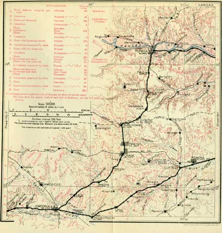
West of Ottawa Junction the railway follows the low flats on the north side of the valley of the Osage (see sheet 2, p. 22) to a point 1-1/2 miles west of Pomona, where it crosses that stream. It recrosses to the north bank just east of Quenemo. This river was named the Marais des Cygnes (swamp of the swans) by the early French trappers, from the fact that large numbers of swans frequented its marshy bottom lands during the winter.
|
Quenemo. Elevation 941 feet. Population 556. Kansas City 72 miles. |
At Quenemo the Santa Fe Railway is crossed by one of the lines of the Missouri Pacific system. This place was named for an Ottawa Indian who lived among the Sac and Fox tribes near Melvern. The surface rock of the valley in this region is shale, which is exposed in some of the cuts, notably in one 20 feet deep a short distance east of milepost 60. Most of the lower slopes of the valley are occupied by deposits of sand and gravel laid down by the river. Near Pomona the slopes on both sides of the valley are surmounted by low cliffs of Oread limestone in two or three prominent ledges. These beds, by their slight westward dip and the rise of the valley in the same direction, are finally brought to water level and crossed by the railway at Melvern.
|
Melvern. Elevation 994 feet. Population 505. Kansas City 80 miles. Olivet. Elevation 1,136 feet. Population 904.* Kansas City 86 miles. |
At Melvern the railway rises out of the Osage Valley and the railway cuts expose in close succession a number of limestones and at several places the intervening shales. At Ridgeton, west of Olivet, the railway regains the summit of the plateau at an elevation of 1,125 feet, or about 100 feet higher than in the region southwest of Olathe. On the summit there is a very instructive view to the northwest, showing a succession of steps formed by the outcrop of the thin but hard ledges of limestones, separated by long slopes of the intervening shales. This entire region is under cultivation, with fields of various crops and extensive pastures.
From Olivet to Neosho Rapids there is a continuous rolling plain of shale, interrupted, between mileposts 92 and 93, by a slope formed by the gently inclined upper surface (dip slope) of the Howard limestone, a relatively hard bed only about 1 foot thick.
|
Lebo. Elevation 1,155 feet. Population 560. Kansas City 94 miles. Neosho Rapids. Elevation 1,092 feet. Population 256. Kansas City 102 miles. |
The coal bed lying below the Howard limestone has been worked at mines in the vicinity of Lebo. This coal is the same bed that is worked in the neighborhood of Scranton and Osage. (See pp. 17, 18.) The bed is 14 to 16 inches thick and is mined by stripping and tunneling.
At Neosho Rapids the railway reaches the bank of Neosho River a large stream flowing in a wide valley floored with thick beds of sand and loam it has itself deposited. Neosho is an Indian word meaning clear, cold water. This valley is followed as far as Emporia. Near milepost 104 the railway crosses Cottonwood River, which in this vicinity occupies the same wide flat as the Neosho and which empties into that stream a mile to the east. The thick accumulation of sand and loam deposited by these streams has reduced their slope and compelled them to follow very crooked courses. Near Emporia the Burlingame limestone, which slopes down from the east, crosses the valley of the two rivers, but it is covered by the alluvial deposits so that its precise location underground is not known. A mile east of Emporia the main line from Holliday by way of Topeka joins the Ottawa cut-off. Near this place the Santa Fe is crossed by a line of the Missouri, Kansas & Texas Railway, popularly known as "The Katy."
| <<< Previous | <<< Contents >>> | Next >>> |
bul/613/sec2a.htm
Last Updated: 28-Nov-2006