|
Geological Survey Bulletin 613
Guidebook of the Western United States: Part C. The Santa Fe Route |
ITINERARY
MAIN LINE WEST OF EMPORIA.
West of Emporia the railway passes over the flat bottom lands on the north side of Cottonwood River to Florence, a distance of 45 miles. The valley is wide near Emporia and as far west as Saffordville, and the shale slopes on the north and south rise gradually to plateaus capped by limestone.

|
|
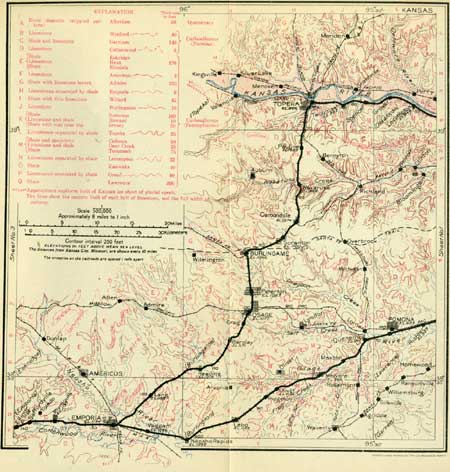
SHEET No. 2 (click on image for an enlargement in a new window) |
|
Saffordville. Elevation 1,142 feet. Kansas City 139 miles.1 |
At Saffordville siding the Cottonwood Valley is much narrower and the limestone caps on the adjacent shale ridges are conspicuous. One limestone ledge is a short distance above the track; 30 to 40 feet higher, with shales intervening, is another two are in limestone. These limestone beds exposed many prominent ledges to the vicinity of Clements, a distance of 22 miles. The lower one (the Nova) is from 7 to 8 feet thick, and in the outcrop breaks out into large blocks with sharp angles and rough surface of chalky-white color. The Cottonwood limestone, the upper ledge, is one of the most continuous and best marked formations of Carboniferous age in Kansas. It carries fossil mollusks of numerous species that are characteristic of the Permian series of the Carboniferous system. (See table on p. ii.) Its upper part consists largely of an aggregate of the fossil foraminifer Fusulina cylindrica, which the quarrymen call "rice" on account of its general resemblance to grains of wild rice. In the vicinity of Strong City, Clements, and Cottonwood Falls there are more than 20 large quarries in this limestone, constituting the largest quarrying industry in the State. The stone is of light color, uniform texture, and generally so free from joint planes that blocks of almost any desired length or breadth can be obtained. The two layers of which the formation consists in most places are only from 2 to 3 feet thick; locally it is in three layers. The Cottonwood stone is shipped great distances to places in Kansas and adjoining States.
1Distances by way of Topeka are given for places west of Emporia. To get the distance traveled by way of the Ottawa cut-off 15 miles should be deducted.
|
Strong City. Elevation 1,174 feet. Population 762. Kansas City 147 miles. |
There is one limestone quarry of considerable size in the northern part of Strong City (see sheet 3, p. 26), north of the railway, and others a mile or two distant on the south side of the river, east of Cottonwood Falls. Strong City, named for W. B. Strong, a former president of the Santa Fe Railway Co., is on the north side of Cottonwood River, and the city of Cottonwood Falls is on the south bank of that stream, 1-1/2 miles south of the railway at this point. At Strong City the Neva limestone is below the surface, and at milepost 133 the Cottonwood limestone also goes under. Within a short distance to the west, however, both of them are brought up again by doming of the beds (see glossary, p. 182), so that near Elmdale they are moderately high in the valley slopes. The underlying Eskridge shale also appears.
| <<< Previous | <<< Contents >>> | Next >>> |
bul/613/sec2b.htm
Last Updated: 28-Nov-2006