
|
Geological Survey Professional Paper 446
Geology of the Guadalupe Mountains, New Mexico |
ECONOMIC GEOLOGY
OIL AND GAS
PREVIOUS EXPLORATION
Up to June 30, 1961, 81 holes had been drilled in search of oil and gas within the report area; all but 17 of these holes are in the Delaware basin (table 2). Eight of the Delaware basin wells yielded oil, and four yielded gas of commercial value. Four of the oil wells were still producing early in 1960.
TABLE 2.—Oil and gas test wells drilled in report area before
June 30, 1961
[Abd., abandoned, dry hole; OW, oil well; AOW, abandoned oil well;
GW, gas well]
| Sec. | Township (S) |
Range (E) |
Location | Status | Well | Altitude (feet) |
Total depth (feet) |
Year completed |
| 16 | 21 | 22 | C, SW, SE | Abd. | Magnolia State "W" 1 | 4,464 | 11,312 | 1948 |
| 22 | 21 | 22 | C, NE, NW | Abd. | Union Federal 1—22 | 4,325 | 5,579 | 1960 |
| 23 | 21 | 22 | C, NW, NW | Abd. | Magnolia Crosby 1—X | 4,250 | 3,043 | 1949 |
| 29 | 21 | 22 | C, SE, NE | Abd. | Magnolia Golden 1 | 4,478 | 3,970 | 1949 |
| 1 | 22 | 21 | C, SE, SE | Abd. | Continental East Texas Hill Unit 1 | 4,573 | 10,596 | 1954 |
| 5 | 22 | 21 | SW, SE, SE | Abd. | Continental-Standard of Texas Bass 1 | 5,511 | 5,889 | 1952 |
| 28 | 22 | 21 | NW, SW, NE | Abd. | Sinclair Federal-Eddy 1—193 | 5,197 | 5,000 | 1961 |
| 32 | 22 | 21 | C, NE, NE | Abd. | Sinclair Federal-Eddy 1—195 | 5,360 | 4,000 | 1960 |
| 32 | 22 | 22 | C, NE, NE | Abd. | Texas Crude Oil State of New Mexico "A" 1—32 | 4,564 | 5,300 | 1961 |
| 6 | 23 | 22 | SW, NW, NW | Abd. | Texas Crude Oil Federal Huapache 1—6 | 5,124 | 3,720 | 1961 |
| 23 | 23 | 22 | SE, SE, NW | Abd. | Humble Huapache Unit 2 | 4,455 | 12,582 | 1957 |
| 35 | 23 | 22 | NW, SW, NW | Abd. | Humble Huapache Unit 1 | 4,425 | 12,631 | 1955 |
| 14 | 24 | 22 | C, SW, SW | Abd. | Humble Huapache Unit 4—1 | 5,502 | 7,950 | 1960 |
| 17 | 24 | 22 | C, NW, NW | Abd. | Union White 1 | 5,709 | 6,737 | 1955 |
| 22 | 24 | 22 | C, SE, NW | Abd. | Humble Huapache Unit 3 | 5,625 | 8,670 | 1959 |
| 25 | 24 | 22 | C, NW, NE | Abd. | British-American Huapache Unit 7 | 5,505 | 3,620 | 1961 |
| 4 | 24 | 26 | C, SW, NE | Abd. | Bauerdorf Schrup 1 | 3,405 | 1,970 | 1951 |
| 14 | 24 | 22 | SE, SW, NE | Abd. | Humble Huapache Unit 5 | 5,352 | 3,505 | 1960 |
| 10 | 24 | 26 | SE, NE, SE | Abd. | Street Investment Co. 1 Bradley | 3,305 | 2,061 | 1949 |
| 11 | 24 | 26 | SW, SW, NE | Abd. | Jos. I. O'Neill, Jr. Federal "D" 1 | 3,291 | 2,014 | 1958 |
| 11 | 24 | 26 | SE, NE, SW | Abd. | Shappell Bradley 9 | 3,281 | 2,026 | 1949 |
| 11 | 24 | 26 | SE, NW, SE | OW | Shappell Bradley 8 | 3,271 | 1,975 | 1949 |
| 11 | 24 | 26 | SW, NE, SE | Abd. | Shappell Bradley 6 | 3,275 | 2,000 | 1948 |
| 11 | 24 | 26 | NE, SW, SE | Abd. | Shappell Bradley 7 | 3,271 | 2,000 | 1949 |
| 11 | 24 | 26 | NW, SE, SE | OW | Shappell Bradley 5 | 3,266 | 1,971 | 1948 |
| 11 | 24 | 26 | SE, SE, SE | OW | Shappell Bradley 2 | 3,260 | 1,968 | 1947 |
| 12 | 24 | 26 | SW, SW, NW | Abd. | R. A. T. Wright, Wright 1 | 3,277 | 2,024 | 1954 |
| 13 | 24 | 26 | NW, NW, NW | OW | Shappell Bradley 1 | 3,260 | 1,969 | 1947 |
| 13 | 24 | 26 | C, NW, NW | AOW | Collins Weiler 1 | 3,245 | 1,969 | 1937 |
| 13 | 24 | 26 | NW, NE, NW | Abd. | Shappell Bradley 4 | 3,260 | 2,015 | 1947 |
| 14 | 24 | 26 | SE, SE, NW | Abd. | Bradley Bradley 1 | 3,275 | 2,114 | 1950 |
| 14 | 24 | 26 | NE, NE, NE | AOW | Grisham Chaytor 1 | 3,255 | 2,320 | 1937 |
| 14 | 24 | 26 | SE, NE, NE | Abd. | Shappell Bradley 3 | 3,253 | 1,978 | 1947 |
| 17 | 24 | 26 | NE, NE, NE | Abd. | E.P. Campbell Lee 1 | 3,349 | 1,920 | 1958 |
| 20 | 24 | 26 | SW, SW, NE | Abd. | Gulf Federal Estill 2—AD | 3,396 | 11,420 | 1960 |
| 23 | 24 | 26 | C, NE, NW | Abd. | Crawford Crawford 2 | 3,270 | 2,000 | 1952 |
| 23 | 24 | 26 | NE, NE, NE | Abd. | Hargrave Hargrave 1 | 3,266 | 2,032 | 1953 |
| 23 | 24 | 26 | NE, NE, SE | Abd. | Hargrave Dean-Smith 1 | 3,260 | 2,005 | 1951 |
| 24 | 24 | 26 | NW, NW, NW | AOW | York & Harper Bradley 1 | 3,263 | 1,986 | 1951 |
| 24 | 24 | 26 | NW, NW, NW | AOW | Leda Oil Elliot-Hargrave 1 | 3,260 | 1,978 | 1953 |
| 24 | 24 | 26 | NW, NW, SW | Abd. | Moran Crawford & Smith 1 | 3,241 | 2,005 | 1938 |
| 26 | 24 | 26 | C, NW, SE | GW | Union Crawford 1—26 | 3,261 | 11,522 | 1957 |
| 27 | 24 | 26 | C, NW, SE | GW | Union Crawford 2—27 | 3,315 | 11,360 | 1960 |
| 28 | 24 | 26 | NE, SE, SW | Abd. | E.P. Campbell Estill 1 | 3,341 | 2,125 | 1958 |
| 29 | 24 | 26 | C, NE, NE | GW | Gulf Estill 1—AD | 3,411 | 12,212 | 1960 |
| 29 | 24 | 26 | SE, SW, NW | Abd. | Martin & Lycette Pardue & Guitar 1 | 3,442 | 1,875 | 1938 |
| 30 | 25 | 25 | C, SW, NE | Abd. | Gulf Federal Kelly 1—A | 3,681 | 11,296 | 1961 |
| 30 | 25 | 25 | C, SW, SW | Abd. | John M. Kelly Federal-Esther 1 | 3,705 | 1,432 | 1958 |
| 34 | 25 | 25 | C, NW, NW | Abd. | Carper Gates 1 | 3,650 | 2,004 | 1949 |
| 9 | 25 | 26 | C, SW, SW | Abd. | Cree Drg. Co. Union-Parke 1 | 3,359 | 2,035 | 1958 |
| 10 | 25 | 26 | SE, SE, SE | Abd. | Brock Jennings 1 | 3,379 | 2,141 | 1951 |
| 10 | 25 | 26 | SE, SE, SE | Abd. | Roach & Shepard Gates 1 | 3,372 | 2,107 | 1948 |
| 11 | 25 | 26 | C, NE, NE | Abd. | Cree Drg. Co. Gulf 1 | 3,365 | 2,215 | 1958 |
| 11 | 25 | 26 | C, SW, NE | Abd. | Gulf Jennings 1—E | 3,350 | 2,167 | 1959 |
| 26 | 25 | 26 | C, SW, SW | Abd. | Cree Oil Co. Ashland 1 | 3,313 | 2,110 | 1958 |
| 1 | 26 | 24 | NW, NW, NW | Abd. | G. C. Weaver Smith 3 | 3,730 | 889 | 1956 |
| 8 | 26 | 24 | NE, NW, NE | Abd. | John A. Yates Matlock 1 | 3,832 | 3,500 | 1956 |
| 9 | 26 | 24 | C, NW, NW | Abd. | Randel Thurman 1 | 3,806 | 595 | 1952 |
| 9 | 26 | 24 | C, NE, SE | Abd. | D. S. Harroun Mayes 1 | 3,737 | 612 | 1957 |
| 10 | 26 | 24 | NW, SW, NW | Abd. | Smith State-Mayes 1 | 3,725 | 600 | 1950 |
| 10 | 26 | 24 | C, SE, NE | Abd. | D. S. Harroun Leeman 1 | 3,715 | 640 | 1957 |
| 10 | 26 | 24 | NW, NE, SW | Abd. | Smith State-Leeman 1 | 3,723 | 675 | 1950 |
| 12 | 26 | 24 | C, SE, NE | GW | Superior Federal 1—134 | 3,878 | 10,237 | 1960 |
| 14 | 26 | 24 | N, SW, NW | Abd. | G. C. Weaver Smith 1 | 3,870 | 2,513 | 1955 |
| 15 | 26 | 24 | C, SW, NW | Abd. | D. S. Harroun Mayes 1 | 3,774 | 767 | 1958 |
| 19 | 26 | 24 | C, NW, SE | Abd. | D. S. Harroun Leeman 2 | 3,715 | 618 | 1958 |
| 22 | 26 | 24 | NW, NW, NW | Abd. | G. C. Weaver Smith 2 | 3,765 | 707 | 1955 |
| 22 | 26 | 24 | NW, NW, NE | Abd. | G. C. Weaver Smith 4 | 3,813 | 788 | 1956 |
| 22 | 26 | 24 | NE, NW, NE | Abd. | G. C. Weaver Smith 5 | 3,830 | 788 | 1956 |
| 22 | 26 | 24 | NE, NE, SE | Abd. | G. C. Weaver Jenson 1 | 3,955 | 956 | 1956 |
| 23 | 26 | 24 | SE, NW, NW | Abd. | G. C. Weaver Smith 1—23 | 3,869 | 902 | 1955 |
| 1 | 26 | 25 | SE, SE, NE | Abd. | W. E. Doolin Milner 1 | 3,490 | 1,870 | 1957 |
| 3 | 26 | 25 | SW, SW, SW | Abd. | W. E. Doolin Erickson 1 | 3,686 | 1,820 | 1957 |
| 26 | 26 | 25 | NW, NW, NW | Abd. | W. E. Doolin McKean 1 | 3,602 | 1,488 | 1957 |
| 2 | 26 | 26 | C, SE, SE | Abd. | John M. Kelly State "EP" 1 | 3,287 | 2,057 | 1958 |
| 5 | 26 | 26 | NE, NE, SE | Abd. | W. E. Doolin Hodges 1 | 3,482 | 1,935 | 1957 |
| 7 | 26 | 26 | C, SE, SW | Abd. | McBride Randel 1 | 3,541 | 2,702 | 1951 |
| 17 | 26 | 26 | SE, SE, NW | Abd. | W. E. Doolin Randel 1—X | 3,472 | 1,832 | 1957 |
| 19 | 26 | 26 | SW, SW, SW | Abd. | W. E. Doolin Price 1 | 3,454 | 1,620 | 1957 |
| 28 | 26 | 26 | NE, NE, SE | Abd. | W. E. Doolin Watkins 1 | 3,432 | 1,870 | 1957 |
All the oil wells are in the Black River field and produce 42° gravity API oil (Stipp and others, 1956, p. 73) from fine-grained sandstone and siltstone just beneath the Lamar Limestone Member of the Bell Canyon Formation. This field is apparently on a small anticlinal nose or structural terrace. Production has never exceeded a few barrels per day per well.
The first gas well was the Union Oil Co. of California Crawford 1—26 (sec. 26, T. 24 S., R. 26 E.), about 2 miles south of the Black River field. This well had an initial production capacity of 62,000 Mcf (thousand cubic feet.) of natural gas per day from a depth of 11,060 to 11,074 feet in Lower Pennsylvanian rocks. The other gas wells are the Gulf Oil Corp. Estill 1—AD (sec. 29, T. 24 S., R 26 E.), the Union Oil Co. of California Crawford 2—27 (sec 27, T. 24 S., R. 26 E.), and the Superior Oil Co. Federal 1—134 (sec. 12, T. 26 S., R. 24 E.). These wells, which also produce from Pennsylvanian rocks, had initial production capacities of 46,000, 7,200, and 347 Mcf per day, respectively.
Of the remaining 52 test wells which have been drilled in the Delaware-basin part of the report area, 47 were drilled no deeper than a few feet below the Lamar Limestone Member of the Bell Canyon Formation, and 3 were apparently drilled into the underlying Cherry Canyon Formation. Thus, only 6 wells in this 255-square-mile area have penetrated pre-Permian rocks, and only 9 have been drilled deeper than the shallowest potential producing zone.
In the shelf area outside the Delaware basin, 17 test wells have been drilled in about 730 square miles of area. All of them were dry holes. Three of the holes were drilled to Precambrian rocks, and eight were drilled into pre-Devonian rocks. The greater concentration of exploratory wells is in the Delaware basin; however, the average depth of the wells in the shelf area is about 4,000 feet greater than the average for wells drilled in the basin where the sedimentary rocks are thicker.
FUTURE POSSIBILITIES
On the basis of results of previous drilling in areas to the east, northeast, and southeast, it appears that the best potential production zones in the Delaware basin are in the Bone Spring Limestone, Pennsylvanian rocks, limestone of possible Devonian age above the Fusselman Dolomite, and the El Paso Formation. The best potential structural conditions for accumulation of oil and gas might be found on the southeast projection of the trend of the Huapache monocline (pl. 1) where buried structure similar to the Huapache thrust zone might be present (p. 42). To date (1961), most of the Delaware-basin oil fields produce from near the top of the Bell Canyon Formation. More such fields may be found.
Exploration for oil and gas in the Guadalupe Mountains area has been disappointing. The greatest potential probably lies in the Lower Permian and Pennsylvanian rocks of the Seven Rivers Embayment, adjacent to the Huapache monocline (pl. 1); but as in the Delaware basin, pre-Pennsylvanian rocks offer possibilities throughout the shelf area.
GYPSUM
Vast deposits of relatively pure fine-grained gypsum in the Castile Formation underlie an area of more than 100 square miles in the southeastern part of the area. These deposits are at or near the surface and are as much as several hundred feet thick. Probably enough gypsum is present to supply the total world demand for centuries, and much of it is of sufficient purity for industrial purposes. However, the price of gypsum has been so low in relation to transportation costs that up to June 1960 no important attempt had been made to exploit the deposits.
Although most of the vast quantities of gypsum in the area are fine grained, some selenite of fair quality is present; but none of optical quality has yet been found. The best potential area for prospecting is in the Yeso Hills, where selenite occurs along the east-northeast-trending linear features indicated on the geologic map (pl. 1). At least one prospect hole has been dug in this area and selenite is abundant around it.
BUILDING STONE
No high-quality building stone is present in the area, but flaggy dolomite from the Tansill Formation has found local use, notably for the construction of buildings at Carlsbad Caverns for the U.S. National Park Service. Other rocks have been used by local residents for houses and stone walls.
GRAVEL
Limestone gravel deposits have been quarried at several places along U.S. Highway 62 for use as road metal. In most places the gravel requires screening, but the supply meets the limited demand.
SODIUM SULFATE
Concentrated brines rich in sodium and magnesium sulfate are present locally in gypsum immediately overlying unaltered anhydrite in the Castile Formation. In 1906 brine was discovered at a depth of 160 feet in a well drilled for water in sec. 30, T. 25 S., R. 27 E., about 1 mile east of the mapped area. In 1934 brine from a depth of 170 feet from another water test hole drilled in sec. 29, T. 24 S., R. 26 E., was analyzed and found to contain abundant sodium sulfate (Lang, 1941, p. 152). Since then, about 65 test wells have been drilled in the mapped area in search for brine in the Castile Formation. Of these test holes, in at least 32 brine was found at depths ranging from 67 to 165 feet. These wells are in sec. 36, T. 25 S., R. 25 E.; secs. 14, 16, 22, 23, 25, 26, 27, 30, 32, 35, and 36, T. 25 S., R. 26 E.; and secs. 2 and 3, T. 26 S., R. 26 E. Until 1957, brine was produced commercially by the Ozark-Mahoning Co. from a well near Paxton water well in Cottonwood Draw. The brine was transported for the purpose of separation of the sodium sulfate more than 100 miles by truck to Monahans, Tex. The operation was stopped for an indefinite period in 1957 because of pumping and transportation costs (Robert S. Fulton, written communication, August 1958). Production figures are not known.
Chemical analyses of brines from four wells, as reprinted from Lang (1941, p. 154), are listed in table 3.
TABLE 3.—Chemical analyses of brines from four wells Eddy
County, N. Mex.
[Laboratory of the U.S. Geological Survey, Midwest, Wyo. 1, Forehand
2, sec. 25, T. 25 S., R. 26 E.; 2, Mullen 1, sec. 30, T. 25 S., R. 26 E.; 3,
Gates-Pardue Guitar 1, sec. 26, T. 25 S., R. 26 E.; 4, D. P. Welch 2,
sec. 8, T.26 S., R. 27 E.]
| Grams per liter | ||||
| 1 | 2 | 3 | 4 | |
| Magnesium (Mg) | 41.3 | 46.2 | 23.5 | 39.6 |
| Sodium (Na)1 | 43.1 | 59.5 | 61.1 | 32.3 |
| Potassium (K) | 16.6 | 1.8 | 4.6 | 1.2 |
| Sulfate (SO4) | 236.7 | 245.5 | 304.1 | 187.2 |
| Chloride (Cl) | 24.8 | 39.7 | 24.4 | 25.4 |
| Carbonate (CO3) | .3 | — | .7 | — |
| Bicarbonate (HCO3) | 1.0 | 4.1 | 1.8 | 1.7 |
| Borate (B4O7) | 2.9 | 10.3 | 7.4 | 4.0 |
| Total solids | 366.7 | 407.5 | 458.0 | 291.4 |
| Specific gravity | 1.290 | 1.326 | 1.363 | 1.236 |
Lang (1941, p. 156-157) stated that meteoric waters percolating through porous weathered gypsum in the vadose zone in the Castile Formation could acquire all the elements that make up the sodium sulfate brines. He further stated that normal ground-water circulation would tend to remove the brine, but that some brines could become trapped in "inverted closures or pockets" on top of massive unaltered anhydrite of the Castile. The presence of significant amounts of magnesium, potassium, and borate in the brines (table 3) suggests that they are residual brines from solution of the Salado Formation which is now present in the area only as residuum at the top of the Castile Formation. Magnesium, potassium, and borate are very rare in the Castile Formation, but potassium and magnesium minerals, at least, are present in some abundance in the Salado Formation east of the Pecos River. Further more, all the brines known in the area occur in or just below the residuum of the Salado.
GROUND WATER
The ground-water resources of the Eddy County part of the Guadalupe Mountains area have been described by Hendrickson and Jones (1952), and Hale (1955) has reported on ground-water conditions in the upper part of Black River valley. The following discussion is in part a summary of those reports but includes minor additional comments.
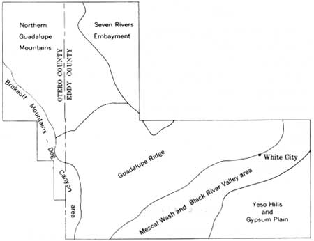
The availability and quality of ground water in the Guadalupe Mountains area vary markedly from place to place, depending on the character and structure of the rocks. For purposes of discussion, the area may be divided into six areas of ground-water availability (fig. 29).
|
| FIGURE 29.—Areas of ground-water availability discussed in text. |
BROKEOFF MOUNTAINS-DOG CANYON AREA
No springs or perennial surface streams occur in the Brokeoff Mountains-Dog Canyon area, and attempts to locate a satisfactory ground-water reservoir there have failed. Nearly all the domestic and stock water used in the area is rainwater stored in cisterns and earth tanks, but a minor amount is trucked in from adjacent areas. The scarcity of available ground water probably can be attributed to the great concentration of high-angle fault planes and joints that provide avenues of drainage and to the scarcity of shallow impermeable beds that might support perched water reservoirs. Any drilling for water here will have a better chance for success if the well is located on the basis of careful study of structural and stratigraphic conditions. The ideal location would be a fault-free syncline underlain by shallow impermeable beds. However, little of the area is free of faults, and impermeable beds are thin and scarce north of Martine Ridge. The part of Upper Dog Canyon east of Martine Ridge may approach ideal conditions.
NORTHERN GUADALUPE MOUNTAINS
The northern Guadalupe Mountains are also without springs or perennial streams, but several drill holes have tapped water near the contact of the San Andres Limestone and the Yeso Formation at depths between 600 and 1,300 feet. It is unlikely that water in sufficient quantity for watering stock will ever be found at shallow depth in this part of the area. Small quantities of water for domestic use may be present in the alluvium of some of the larger canyons.
SEVEN RIVERS EMBAYMENT
No permanent surface streams or springs are in the Seven Rivers Embayment. Potable ground water generally is present in quantities sufficient for domestic and stock-watering uses, but its depth is difficult to predict. Wells drilled near the west edge of the embayment, on or near the San Andres Limestone outcrop, generally do not strike water at depths shallower than 600 to 900 feet, but locally the arroyo gravels may contain small quantities of water at shallow depth. Toward the east, water is obtained from the Grayburg Formation at depths of 75 to 300 feet.
GUADALUPE RIDGE
The occurrence of ground water in the Guadalupe Ridge area is erratic, as it is dependent on variable local structural and stratigraphic conditions. Where structural conditions are favorable, water in sufficient quantity and of suitable quality for stock and domestic uses is often present in dolomite and limestone beds that overlie relatively impervious clastic beds in the San Andres Limestone, sandstone tongue of the Cherry Canyon Formation, the Artesia Group, and the Capitan Limestone. Where topographic conditions permit, water from these perched aquifers comes to the surface in nearly 50 seeps and springs, 2 of which maintain short stretches of surface streams. Sitting Bull Spring (sec. 9, T. 24 S., R. 22 E.), the larger of these 2 springs, emerges from a dolomite tongue of the San Andres Limestone which overlies relatively impervious clastic beds of the sandstone tongue of the Cherry Canyon Formation. The flow from the spring irrigates a small apple orchard near the mouth of Sitting Bull Canyon and furnishes drinking water to the U.S. Forest Service Recreation area (fig. 23).
The stream gravels of Dark Canyon, and possibly other canyons, locally contain important quantities of shallow ground water in the Guadalupe Ridge area. Where the limestone bedrock rises near the surface, springs emerge from the overlying alluvium in Dark Canyon in sec. 25, T. 24 S., R. 22 E., and sec. 31, T. 24 S., R. 23 E. Water from these springs is used to irrigate fields near the X-Bar Ranch headquarters.
Drilling for water in the Guadalupe Ridge area has produced numerous dry holes. Where water has been found, its depth ranges from a few feet to several hundred feet. Probably the percentage of successful water wells in the area could be increased greatly if drilling were done in synclinal areas which geologic relations indicate are underlain by relatively impervious siltstone beds that could support perched water.
MESCAL WASH AND BLACK RIVER VALLEY AREA
The Mescal Wash and Black River valley area is underlain by more available ground water than the mountain areas. This ground water comes to the surface in nearly a dozen springs and seeps, the most notable being Blue, Rattlesnake, and Geyser Springs, each of which flows generally in excess of 1,000 gpm (gallons per minute). Blue Spring, the largest spring, has an average flow in excess of 5,000 gpm and furnishes irrigation water to a sizable farming development near Black River Village. The extensive gravel deposits of Mescal Wash, south of Rattlesnake Canyon and west of Black River, probably comprise the most dependable reservoirs of potable ground water in the entire report area. Here, large volumes of water are pumped for irrigation from depths of 100 to 300 feet. North and east of Rattlesnake Canyon and along Black River itself, where the gravel deposits are thin to absent, the occurrence and quality of ground water is much less predictable. In general, the waters here contain more sulfate than those in Mescal Wash and are nearly unpotable. A detailed analysis of the ground-water conditions in the Mescal Wash and Black River valley area was made by Hale (1955).
YESO HILLS AND GYPSUM PLAIN
In the Gypsum Plain, small amounts of highly gypsiferous water, probably from fractures in the Castile Formation, reach the surface at Cottonwood Spring (sec. 35, T. 25 S., R. 25 E.), Ben Slaughter Spring (sec. 7, T. 26 S., R. 26 E.), and Jumping Spring (sec. 17, T. 26 S., R. 26 E.). The surface drainage on the Castile Formation is apparently controlled by an eastward-trending fracture system (Hayes, 1957; Olive, 1957, p. 356-357), and wells drilled here in valley bottoms often tap water at shallow depth. Water from the Castile Formation or from gypsiferous alluvium derived from the Castile Formation generally is suitable for livestock, but a sulfate content of as much as 1,500 to 1,800 ppm (parts per million) is not unusual (Hendrickson and Jones, 1952, p. 163-164). The only ground water known near the east edge of the area is the heavy sulfate brine discussed on pages 56-57.
| <<< Previous | <<< Contents >>> | Next >>> |
pp/446/sec9.htm
Last Updated: 13-Feb-2008