
|
Geological Survey Professional Paper 604
On Batholiths and Volcanoes—Intrusion and Eruption of Late Cenozoic Magmas in the Glacier Peak Area, North Cascades, Washington |
LATE EPISODE OF VOLCANISM: GLACIER PEAK VOLCANO AND ASSOCIATED ROCKS
(continued)
PETROLOGY OF THE GLACIER PEAK LAVAS
(continued)
PYROCLASTIC DEPOSITS AND VALLEY FILLS
The most recent eruptions of Glacier Peak volcano have been characterized by violence that may signify the expulsion of gas-rich magmas for the first time. The rise and nearly coincident crumbling of a gassy, vesicular plug is the probable source of a giant debris fan that fills the Suiattle valley, (pl. 1; fig. 42). Pumice and ash subsequently erupted lie in a widespread blanket (overprint on pl. 1; fig. 43) and are major components of a debris fan in the White Chuck valley that was built by streams and numerous mudflows. On this White Chuck fill is a cliff-forming, columnar-jointed layer of ash-flow tuff overlain by reworked pumice deposits.
|
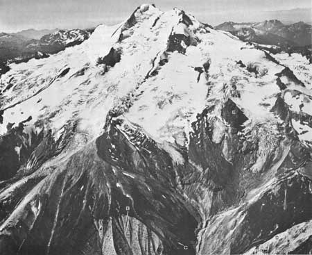
| FIGURE 42.—Glacier Peak from the east; view shows apex of Suiattle fill (A) between Chocolate Glacier (middle left) and Dusty Creek (right foreground). The escarpment (B) shows large lava blocks and the irregular beds which dip away from the volcano at the bottom of the photograph. Interbeds (C) of the lava in the fill (as shown best in fig. 44) make cliffs just to the right of the escarpment. Also visible at lower right are the white kaolinitic tuffs and breccias (D) of the Gamma Ridge unit. The Gamma Ridge rocks extend around the head of Dusty Creek and underlie the prominent dacite cleaver (E) that rises between tongues of Dusty Glacier (see fig. 21). Photograph by Austin Post. |
|
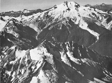
| FIGURE 43.—Glacier Peak from the east; view shows Suiattle fill between Chocolate Creek, Dusty Creek, and Suiattle River at center left. The break in slope in the fill escarpment on Chocolate Creek (A) marks the possible unconformity in the text. Note the same surface occurring on the small patch of fill (B) to the left of the lower Chocolate Glacier. The light-gray slopes on the broad ridge left of the glacier are underlain by the pumice blanket which also underlies vegetated slopes on the Suiattle fill at lower right. Small remnants of this blanket (C) cling to the foreground ridge above High Pass. The breached crater of Glacier Peak lies between the highest summit on the south and the broader, lower summit on the north (right). The black lava cleaver (D) at the head of the Suiattle River lies above the Sitkum stock, which is exposed as white slabs. The gullied slopes above and to the right of the cleaver are Gamma Ridge breccias. Photograph by Austin Post. |
All these elastic rock are obviously young; the debris fans and ash-flow tuff fill the previously glaciated canyons of the Suiattle and White Chuck Rivers, and the pumice mantles the sides and tops of present ridges. A few flows are intercalated with Suiattle fill in upper Dusty (fig. 44) and Chocolate (fig. 43) Creeks. Some of the youngest lava flows that cover the bottom of glaciated canyons or occur on the summit cone may be younger than the elastic deposits, but the volume of such young lava is small compared to the amount of the volcaniclastic debris.
|
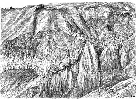
| FIGURE 44.—Interbeds of lava in the Suiattle fill above upper Dusty Creek as barely visible in deep shadows on figure 42. Note the lava-filled valleys that show a complex history of erosion, eruption, and deposition. Flows in lower well-consolidated fill end abruptly at a major unconformity. Sketched from a photograph by Ed Hanson. |
FILL OF THE SUIATTLE RIVER VALLEY
A debris fan on the east side of Glacier Peak (pl. 1) extends from an apex high on the volcano (7,000 feet, fig. 42) down the Suiattle River to half a mile below the mouth of Canyon Creek (fig. 45). This great fan of unconsolidated volcanic debris has surrounded the ridge spur crossed by Chocolate Creek, filled the Suiattle River valley, and pushed the river against bedrock slopes on the east (fig. 58). The volume of the debris fan is about one cubic mile. Dusty Creek, Chocolate Creek, and to a lesser extent the Suiattle River have cut awesome canyons in the fill, mostly along its sides. In Dusty Creek strong winds sweeping past the steep cuts (fig. 42) produce dust clouds visible for miles.
|
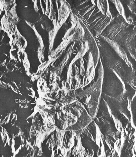
| FIGURE 45.—Radar image of Glacier Peak that emphasizes the smooth constructional surface of the Suiattle fill (A). The map (B) at Chocolate Creek across the spur ridge is particularly apparent (see fig. 58). Note the smooth constructional surface of the valley-bottom flow (C) in Vista Creek. |
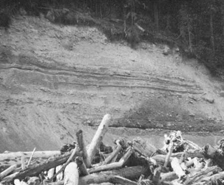
The bulk of the fill debris is sand, with lesser grit and gravel; silt is not abundant. Lava clasts, a few of which are as much as several yards across, are conspicuous and fairly numerous. Bedding is discontinuous, and well-sorted or crossbedded lenses of sand a few inches or feet thick, as well as gravel-filled or sand-filled channels, attest to deposition by streams or slurries (fig. 46). Most of the unsorted and ungraded beds, many of which are 20 feet thick, are probably the products of mudflows, although a few could be moraines. The scattered large blocks of lava also indicate transport by mudflows or glaciers (Ford, 1959, p. 282).
|
| FIGURE 46.—Bedding in Suiattle fill near mouth of Dusty Creek. Sorted beds of variable thickness are indicative of stream or thin-slurry flood deposition; lower thick unsorted bed with vague layering may be a mudflow. |
The alternation of stream and mudflow deposits indicates that the Suiattle fill grew sporadically over a long period of time, not in a few days or weeks as envisioned by Ford (1959, p. 297). A long halt in the growth of the fill is suggested by an interfill unconformity (figs. 43, 44), which truncates lava flows and interbedded clastic debris. Ford (1959, p. 276) interpreted the unconformity in Chocolate Creek (and other similar surfaces downstream) as the "surface of a [younger] valley fill" that lies within the canyon of Chocolate Creek. In upper Dusty Creek, the volcaniclastic materials below the unconformity are stained red. Farther down Dusty Creek (near an altitude of 4,000 ft), a well-defined color change from buff or variegated in the lower part of the fill to purplish white or pink in the upper part may represent this (or another) unconformity. The establishment of the Chocolate Creek drainage on the fill and the ensuing history of erosion and renewed deposition of fill (fig. 58) also indicate a fairly long history of growth. Lack of organic debris in the fill indicates the area was barren during deposition. We believe this barrenness was due to a rigorous climate, but Ford (1959, p. 282, 293) proposed that it is evidence of rapid growth.
Most of the coarse angular clasts of the Suiattle fill are diktytaxitic dacite that contains hornblende or hypersthene and hornblende. This lava is unlike most of the lavas of the volcano. The sand of the fill consists of crystal fragments of hornblende, plagioclase, a little olivine, and glass charged with microlites. Almost all the glass occurs as angular pieces, not as shards.
Near the saddle north of Disappointment Peak above 9,500 feet, small bread-crust bombs (sample 19, table 4) are scattered through a deposit of coarse white crystal ash that may be the near-vent facies of the Suiattle fill. The ash is composed of crystal sand and angular lumps of vesicular glass very similar to the sand and rock fragments composing the bulk of the Suiattle fill. However, the refractive indices of the glass in the ash and the glass in the fill are not the same (fig. 47).
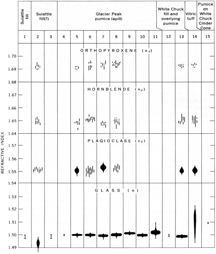
|
|
FIGURE 47.—Optical properties of minerals and glass that occur in
pyroclastic ejecta and in clasts and that comprise the Suiattle and
White Chuck fills, Glacier Peak volcano. Indices of refraction
±0.002 of Nos. 1, 3, 4, 12, and 15 were determined by
conventional oil immersion techniques; properties of No. 11 were
summarized from Steen and Fryxell (1965, p. 880). All other data were by
R. E. Wilcox (written commun., 1965), who used the focal plane masking
technique (Wilcox, 1960) and the spindle stage (Wilcox, 1959); solid
figures represent the estimated range and predominant refractive index
as determined in random mounts of crushed fragments; each short vertical
line represents index and range of a single crystal fragment. (click
on image for an enlargement in a new window)
1. Vesicular vitrophyre from Suiattle fill, Glacier Peak quadrangle, specimens RWT—127—62, RWT—126b—62, DFC—136—62. 2. Vesicular vetrophyre from 9,600-foot altitude just south of summit of Glacier Peak, Glacier Peak quadrangle; occurs with bread-crust bomb (sample 18, table 4). Specimen RWT—135—61. 3. Bedded white ash on north side of Dusty Creek, Glacier Peak quadrangle. Specimen DFC—119—62. 4. Ash and pumice lapilli on or near surface of Suiattle fill, Glacier Peak quadrangle. Specimen DFC—84—62. 5. From 4-1/4 miles southeast of summit of Glacier Peak, on ridge crest near summit of Tenpeak Mountain, Glacier Peak quadrangle. Specimen DFC—24—60. 6. From a recent mudflow at mouth of White Chuck River, about 17 miles northwest of Glacier Peak summit. Specimen 61P4. 7. Gray lapilli from lower part of young alluvium, Chiwawa River at mouth of Phelps Creek, Holden quadrangle 19. 2 miles east of Glacier Peak summit. The glass fraction has been analyzed (Powers and Wilcox, 1964, p. 1334, table 1, column III). Specimen 56P24. 8. Yellow lapilli from upper part of young alluvium. Specimen 56P25 from same locality as specimen 56P24. 9. An upper layer of alluvium about 2 feet thick on north fork Entiat River, 5.0 miles southeast of Duncan Hill Lookout. Specimen 63W73. 10. A lower layer of alluvium about 2 feet thick, below layer of specimen 63W73 and separated from it by about 6 inches of "soil" (?). Specimen 63W74. 11. Five specimens on a line extending east from Glacier Peak, as given by Steen and Fryxell (1965, p. 879). 12. Pumice lapilli from the White Chuck fill, Glacier Peak quadrangle; specimens RWT—174—62, RWT—125—62, DFC—263, DFC—363. 13. Yellow lapilli overlying vitric tuff (RWT—191—61), east side of White Chuck River, 4-1/2 miles west-northwest of summit of Glacier Peak, Glacier Peak quadrangle. Specimen RWT—193—61. 14. Vitric tuff from east side of White Chuck River, 4-1/2 miles west-northwest of summit of Glacier Peak. Specimen RWT—191—61. 15. Weathered yellow pumice from top of White Chuck Cinder Cone. Specimen DFC—80—61. |
The source of the debris comprising the Suiattle fill is poorly defined. The material seems to have issued from a small area above the apex of the fan, presumably under the upper Chocolate Glacier. Such a high local source and the preponderance of a rock type unusual elsewhere in the volcano rule out the possibility that the fill is moraine, outwash, or the product of normal stream erosion of lavas exposed in the cone, even though much of the debris is indistinguishable from such sediments. That the Suiattle fill was fed by the rise and periodic crumbling of a vesicular hornblende dacite plug or spire is suggested by the vesicular character of the angular dacite clasts, the prevalence of hornblende associated with viscous extrusions elsewhere (Williams, 1942, p. 155), the evidence that the source area was small, and the fact that numerous mudflows issued repeatedly from the source area. Wise (1967, p. 347) has described a more obvious example of plug-dome collapse and resultant fan on Mount Hood, where the hornblende andesite fragments in the fill match a remnant of the dome in the crater.
Ford (1959, p. 273) considered the Suiattle fill to be a pyroclastic deposit. One thin layer of ash and pumice lapilli was found in a young part of the fill near the apex of the deposit, and Carithers (1946, p. 34) reported finding pumice overlain by gravel and sand near the mouth of Chocolate Creek. These occurrences probably represent reworked parts of the fill and the younger pumice blanket. This interpretation is supported by the fact that glass in the pumice and in the ash overlain by fill has the same refractive index as the glass in the pumice deposit overlying the fill elsewhere (fig. 47). Much buoyant pumice could have been winnowed out of the stream-sorted layers in the Suiattle fill as it was being deposited, but absence of pumice and the scarcity of shards in virtually all the deposit are not to be expected if the fill had been produced largely by pyroclastic eruptions.
A deposit of dazzling white, fairly well sorted sand clings to the north side of Dusty Creek and is tentatively classed as a remnant of the Suiattle fill. Thin cross bedded layers rich in small pumice lapilli are common. The largest clasts are pumice and some gray and brown aphanite fragments as much as 1 cm across. The bulk of fine- to medium-grained sand is composed largely of crystals of plagioclase, hypersthene, and green hornblende, and a few fragments of dirty brown and clear glass (n=1.503±0.001). These sands appear to underlie an outlier of Glacier Peak lava (Crowder and others, 1965). Yet they are too unconsolidated and unaltered to belong to the Gamma Ridge suite. Their fair sorting, bedding, and crossbedding suggest a fluviatile origin, and their rock fragments are more like the later pyroclastic eruptive rocks of Glacier Peak than its earlier lava flows. Perhaps they are plastered on the side of the canyon and are related to the Suiattle fill. The overall homogeneity which distinguishes these sands from the fill with which they are correlated might be explained if the sands were deposited in a lake formed between the fill and the side of Gamma Ridge.
PUMICE DEPOSITS
The most recent eruptions of Glacier Peak sowed pumice and ash over a large area. The extent and age of the ash has been the subject of much study because of its great usefulness for dating and correlating post glacial events over much of the Northwest (see summary by Fryxell, 1965, p. 1288). During or immediately after the eruptions of pumice and ash, a great deal of pumice was flushed down Kennedy Creek and partly filled the White Chuck valley. A thick bed of tuff was deposited by a nuée ardente on top of this fill and was quickly overlain by more pumice washed from the highlands. Except for this occurrence in the White Chuck valley, most of the pumice deposits are concentrated near the summit or east of Glacier Peak (pl. 1) and thin markedly eastward. Thickness of the deposits ranges from inches to many feet; the thickest are on the Suiattle fill and on the broad ridge south of Chocolate Creek (pl. 1). Average diameter of lapilli decreases eastward and is half an inch (some as much as 3 or 4 inches) in the Chiwawa Valley bottom, a third of an inch along the Entiat, less than a quarter of an inch in the Columbia River area, and less than a tenth of an inch on the Columbia Plateau (Carithers, 1946, p. 33).
Distinguishing primary airfall pumice from slightly reworked pumice is difficult. Indeed, the original air-fall blanket on the snowclad volcano and on the crags and steep slopes of the North Cascades must have been dissected almost immediately. The remnants of pumice in saddles atop precipitous ridges (fig. 43) or on broad ridges near the volcano (pl. 1) are probably little reworked. In most lower places, however, lenticular layers of pumice which show sorting and crossbedding indicate water deposition. As discussed by Carithers (1946, p. 32-47), such fluviatile features are conspicuous in the deposits which lie in the valley bottoms of the Chiwawa and Entiat Rivers. The pumice layer overlying the vitric tuff in the White Chuck valley was examined in a 35-foot section just north of Glacier Creek. Here the fluviatile nature is shown by thin layers and lenses of pumice sand, crossbedding, and a basal layer of poorly sorted pumice sand containing rounded lava cobbles.
In the Chiwawa valley (at Trinity in roadcuts above the mill site) and in the Entiat valley near Cottonwood (Cater, 1967, written commun.), layers that are a few inches thick and are thought to represent soil were observed, but these may well represent breaks in deposition of reworked material rather than separate eruptions. In the Chiwawa and Entiat deposits, buff pumice commonly overlies gray or gray and buff pumice, and the two are separated in many places by a thin layer of pumice sand (Carithers, 1946, p. 35-37, 39-47; Wilcox, written commun., 1965). The upper buff layer contains rounded lapilli and pebbles of granitic rock, gneiss, and schist, whereas the gray lower layer contains angular lapilli only; the lower layer is air laid, the upper, reworked (Carithers, 1946, p. 32). These observations are in agreement with ours on the flanks of Glacier Peak, where weathered lapilli are buff and fresh lapilli are white to gray. Except for a few very local deposits, we have found no evidence of more than one Glacier Peak pumice eruption. The vitric tuff on the White Chuck fill (see p. 43) is the deposit of another local pyroclastic eruption, but one which was only a little younger than, or contemporaneous with, the large pumice eruption.
The pumice lapilli (samples 16 and 17, table 4) consists of highly vesicular, clear brown glass surrounding a few small crystals and crystal fragments of euhedrally zoned andesine and small prisms of greenish-brown hornblende plus less abundant hypersthene, magnetite, quartz, and cristobalite (?). No clinopyroxene occurs, even in specific gravity fractions heavier than 3.3 (R. E. Wilcox, written commun., 1965). The hypersthene (En63-70) and plagioclase (An33-53) (see fig. 47) are essentially similar in composition to the plagioclase and hypersthene in the Glacier Peak lavas. The abundance of greenish-brown hornblende and the lack of clinopyroxene in the pumice distinguish it mineralogically from most of the older lavas. The abundance of hornblende may be due to high water-vapor pressure that built up in the magma just before eruption of the pumice (Fiske and others, 1963, p. 89). The glass making up the pumice lapilli has a refractive index of about 1,500. This index is a little higher than the index of the glass in the Suiattle fill and lower than that in the vitric tuff of the White Chuck valley (fig. 47).
FILL OF THE WHITE CHUCK RIVER VALLEY
The debris fan that fills the White Chuck valley appears to have debouched from Kennedy Creek, and it may have dammed the White Chuck River (Ford, 1959, p. 285). The fill is overlain by a cliff-forming layer of vitric tuff which supports a conspicuous terrace mantled with pumice lapilli. Westward, the fill and overlying tuff underlie a terrace that extends downstream to the mouth of Camp Creek. Beyond this, numerous low terraces containing fragments of the tuff extend for several miles down the White Chuck valley (Vance, 1957, p. 296). The volume of the White Chuck fill to the point of reworking at Camp Creek is roughly a third of a cubic mile.
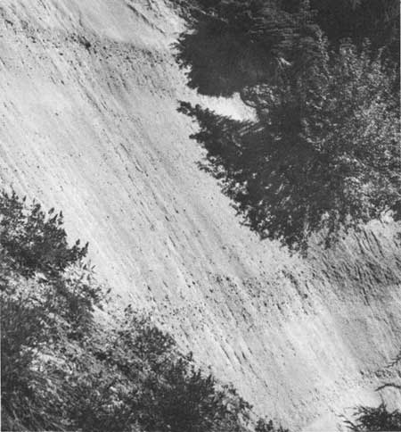
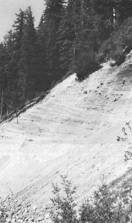
Ford (1959, p. 290) found little stratification in the White Chuck fill and suggested that much of it was direct airfall material of a single eruption. However, several layers of unbedded sands as much as 20 feet thick occur in excellent exposures of the White Chuck fill, just above Kennedy Hot Spring (fig. 48). Some layers show a vague vertical-size grading which coarsens upward, and some contain abundant dacite clasts about 1 inch across and rare ones as much as 6 inches across. The poorly sorted and thick beds probably are mudflow deposits, although we observed little muddy matrix. They are interbedded with lenses of sand, silt, and conglomerate which are locally crossbedded (fig. 49) and probably were deposited by streams. No organic debris was found. The White Chuck fill thus seems to have been deposited on barren land by mud flows and streams in much the same fashion as the Suiattle fill. Its clasts, however, differ from those of the Suiattle fill; the principal clasts in the White Chuck fill are pumice lapilli (n=1.498-1.500±0.002, fig. 47), not the vesicular and much denser lava clasts constituting most of the Suiattle fill. Lenses of ash and a few cobbles of alaskite and granitoid rock were also found in several places throughout the White Chuck fill. The rare volcanic rock clasts present include vesicular dacite like that in the Suiattle fill and denser lavas of various textures (see also Ford, 1959, p. 285). Orthopyroxene, as well as hornblende and plagioclase, are conspicuous as crystal fragments in the White Chuck fill.
|
| FIGURE 48.—Mudflow deposits in White Chuck fill just above river at Kennedy Hot Spring. Unsorted bed in center of photograph is about 20 feet thick. |
|
| FIGURE 49.—Crossbedded, locally well-sorted sands and gravels in the White Chuck fill deposited by streams. Note gravel-filled channel at upper right (arrow). |
The high percentage of pumice (and some ash) in the White Chuck fill suggests that the ultimate source of much of the material in the fill was from pyroclastic eruptions. On the basis of refractive index and mineralogy, the pumice appears identical to that of the widespread pumice blanket described in the preceding section. Thus, the White Chuck fill may have been built by some of the first mudflows and streams which attacked the pumice that had fallen high on the cone. On the east side of the volcano, similar pumice-laden mudflows and streams added their loads to the pumice falling directly onto the already existing Suiattle fill.
VITRIC TUFF IN THE WHITE CHUCK RIVER VALLEY
Overlying the White Chuck fill is a layer of cliff forming vitric tuff (pl. 1). How far below Camp Creek the layer originally extended is unknown, but large blocks of the tuff occur farther downstream in reworked parts of the White Chuck fill. Small remnants of the tuff and underlying fill that cling to the west side of the incised White Chuck River indicate that the fill must have been continuous across the valley when the tuff was deposited. As the river had not yet had time to begin incising the fill appreciably, the fill and overlying tuff are very close in age. The continued deposition of reworked pumice on top of the tuff supports this supposition.
The tuff forms well-exposed cliffs 15 to 50 feet high along the White Chuck River and its tributaries. Pumice Creek has cut a precipitous scenic gorge through it. Irregular vertical columnar joints are evident in most cliffs. The lowermost few feet is friable and poorly jointed and locally weathers back to form a recess. The tuff has weathered brown and gray in most outcrops, but near the mouth of Fire Creek, trail cuts reveal the fresh white interior. Scattered throughout the tuff are numerous pumice lapilli, a few blocks of dacite, and cognate fragments of tuff (Ford, 1959, p. 294). No horizontal variations in the tuff have been noted by us or by Ford (1959, p. 292), and clasts show no sign of sorting, layering, or flattening. The matrix that makes up most of the tuff consists mainly of cloudy brown glass with no hint of shards (n=1.495-1.520; compare with other pyroclastics, fig. 47); the glass envelops crystals and crystal fragments of oscillatorily zoned plagioclase (nx about 1.547-1.553, An37-48), greenish-brown hornblende (nx about 1.644-1.653), hypersthene (nx about 1.690-1.694, En64-67), and minor accessories including some biotite (identifications and optical properties by R. E. Wilcox, written commun., 1965). The matrix shards show no flattening or streaking. A chemical analysis (sample 15, table 4) shows that the composition is dacitic and quite similar to that of the younger dacite lavas of the peak.
Ford (1959, p. 294-295) recognized the vitric tuff as the product of an avalanche of hot pyroclastic debris such as a nuée ardente. Though warm enough to be lithified and to form columnar joints, the sheet was either too cool or too thin to weld. More rapid cooling at the base is shown by the more friable character of the lowermost few feet. The lack of any organic debris in the pumice beds above and below the tuff suggests that the terrane was barren.
The most likely vent from which the nuée ardente poured was the summit area above Kennedy Creek, yet the tuff sheet is found only on gentle slopes at the base of the cone. Either the tuff has been eroded from the steeper upper slopes, and this seems unlikely, or the glowing avalanche did not settle until it reached flats at the base of the mountain. The presence of cognate (?) tuff fragments in the tuff cannot be readily explained.
OTHER PYROCLASTIC DEPOSITS
Most of the pumice and ash deposits near Glacier Peak which have already been described have a characteristic mineralogy and refractive index of glass, and they stem from two eruptive phases in one period of relatively short duration. However, three other deposits of pyroclastic debris in the Glacier Peak area are apparently unrelated to this eruptive period, and one of these may not even come from the Glacier Peak volcano.
In the upper Suiattle valley are poor exposures of a well-consolidated but irregularly layered tuff (sample 18, table 4). Crystal fragments of plagioclase and clinopyroxene are in a brown matrix of devitrified glass. Flattened pumice lapilli are still recognizable. The layering, the lack of hornblende, and the presence of clinopyroxene serve to distinguish this rock from any other pyroclastic material at Glacier Peak. Gamma Ridge rocks occur nearby, but are all more highly altered than the tuff.
A thin layer as much as 2-1/2 inches thick of highly weathered hornblende pumice and ash overlies basaltic cinders near the center of the eroded White Chuck Cinder Cone southwest of the volcano. This pumice resembles the Glacier Peak pumice in all respects except its glass, which has a considerably higher refractive index (No. 15, fig. 47). Judging from the refractive index, this pumice does not belong to the main Glacier Peak pumice, and its silicic composition makes it unlikely that it came from the cinder cone.
Overlying this pumice and ash at the White Chuck Cinder Cone is a layer of white ash which may be equivalent to a widespread ash described by Carithers (1946, p. 32). He found this ash at grass roots and assumed it was the product of the youngest Glacier Peak eruption. We did not find this ash anywhere but at the White Chuck Cinder Cone (nor did Ford, 1959, p. 250-307). Perhaps it is the widespread Mount Mazama ash, reported by Fryxell (1965, p. 1288) as 6,600 years old (see p. 47).
AGE AND HISTORY
The age of the pumice deposits has been determined by a carbon-14 date of 12,000±310 years B.P. obtained on a shell fragment found "within a deposit of inter-bedded fine sand, silt, and small pellets of Glacier Peak ash" (Fryxell, 1965, p. 1289) which occurs on the Columbia Plateau. The date is a minimum and agrees with stratigraphic relations of ash and glacial deposits in western Washington (Fryxell, 1965). Previously reported carbon-14 dates of about 6,700 years B.P. for Glacier Peak ash have turned out to be dates of the culminating Mount Mazama eruption (Fryxell, 1965). Distinguishing the Mount Mazama ash from the Glacier Peak ash is generally facilitated by differences in the refractive index of the glass, the heavy mineral assemblage, refractive indices of the heavy minerals, and the titanium dioxide content of pumice from the two eruptions (Powers and Wilcox, 1964; Steen and Fryxell, 1965; Wilcox, 1965; Czamanske and Porter, 1965).
Glacier Peak must have had its largest pumice eruption after the peripheral canyons of the Suiattle and White Chuck were free of ice, for the pumice is incorporated in the debris fan which fills the glaciated White Chuck valley and blankets the debris fan which fills the glaciated Suiattle valley. Neither fill has been appreciably eroded by glaciers (pl. 1). These peripheral valleys certainly had ice in them during the last maximum advance of Cascade glaciers, an advance that lasted until at least 17,000 years B.P. in the North Cascades (Evans Creek Stade of the Fraser Glaciation, Armstrong and others, 1965, p. 324, 326). Close to the Cascade Crest and the heavily glaciated volcano, the upper parts of the valleys may well have retained glaciers even into the subsequent Vashon Stade, which marked considerable waning of most alpine glaciers and lasted until sometime before 13,500 years B.P.3
3During the Vashon Stade, when continental ice of the Puget lobe dammed the White Chuck valley, the White Chuck glacier had retreated from the lower valley, and left a lake in which silts and clays were deposited (Vance, 1957, p. 293). Indeed, the continental ice carried rocks foreign to the valley at least 7 miles up the valley (Vance, 1957, p. 293). Analogous conditions prevailed in the Carbon River valley northwest of Mount Rainier (Armstrong and others, 1965, p. 326) when a general warming ensued in the early part of the Everson Interstade, which followed the Vashon Stade (Armstrong and others, 1965, p. 324).
Ford (1959, p. 297-298) interpreted the vitric tuff of nuée ardente origin, the widespread pumice deposits, and both the valley fills as products of a single eruptive phase, the deposits being laid down in "rather rapid succession." We distinguish several eruptive phases which took place close together in time. They are summarized thus: Shortly after about 13,500 years B.P., a vesicular dacite dome or plug rose on the east side of the volcano. The cone crumbled as it rose, and melt waters helped spread the debris into the great fan that filled the ice-free but still barren Suiattle valley. About 12,000 years B.P. and still before vegetation established, a violent summit eruption ejected large volumes of pumice and ash. Most of the debris was spread eastward by prevailing winds, but on the west side of the cone, pumice was washed from the volcano by melt-water floods and streams and was deposited as a debris fan in the ice-free White Chuck valley. On the Suiattle River side of Glacier Peak, streams likewise spread pumice onto the Suiattle fan. Shortly thereafter, before the White Chuck River had entrenched itself into its debris fan, hot pyroclastic debris descended Kennedy Creek as a nuée ardente and settled onto the White Chuck fill to form the columnar-jointed vitric tuff. Tributary streams near the volcano continued aggrading until eruptions stopped or until most of the pumice was swept off the steep flanks of the cone. Then the rivers and streams began incising the valley fills.
| <<< Previous | <<< Contents >>> | Next >>> |
/pp/604/sec3c.htm
Last Updated: 28-Mar-2006