
|
Geological Survey Professional Paper 604
On Batholiths and Volcanoes—Intrusion and Eruption of Late Cenozoic Magmas in the Glacier Peak Area, North Cascades, Washington |
TABLE OF CONTENTS
Introduction
Problem
Acknowledgments
Cloudy Pass batholith and associated rocks
Geologic setting and age of intrusion at the level exposed
Structure and contact relations
General features
Contact metamorphism
Lithology
General features
Dark-colored phase
Light-colored phase
Alaskite dikes
Inclusions and dikes of hornblende tonalite porphyry
Intrusive breccia, dikes, and small masses
Intrusion and differentiation
Early episode of volcanism: volcanic and volcaniclastic rocks of Gamma Ridge
General character and age
Petrology
Widespread eruption of Gamma Ridge type rocks
Origin and relation to the Cloudy Pass batholith
Late episode of volcanism: Glacier Peak volcano and associated rocks
Previous work
General features of the volcano
Crater
Disappointment Peak flow
Stratigraphy of the lavas
Age of the volcano
Petrology of the Glacier Peak lavas
Textural variations
Mineralogy
Quartz
Plagioclase
Pyroxene
Hornblende
Olivine
Biotite
Other minerals
Inclusions
Alteration
Pyroclastic deposits and valley fills
Fill of the Suiattle River valley
Pumice deposits
Fill of the White Chuck River valley
Vitric tuff in the White Chuck River valley
Other pyroclastic deposits
Age and history
Other volcanic rocks near Glacier Peak
White Chuck Cinder Cone
Indian Pass cinder cone
Dishpan Gap cinder cone
Flow of Lightning Creek
Dikes
Other centers of volcanism
Hot springs
Composition of Glacier Peak lavas and how it varies in time
Development of the Glacier Peak scene
Position of the Cascade Crest
Gamma Ridge eruptions and resultant drainage changes
Glacier Peak eruptions and resultant drainage changes
Structures that guided the late Cenozoic magmas
Index (omitted from the online edition)
|
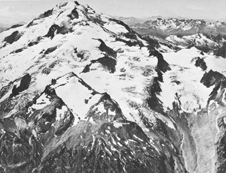
| FRONTISPIECE.—Glacier Peak from northeast. Chocolate Glacier, far left; Dusty Glacier, middle left; Vista Glacier, right; and Ptarmigan Glacier, far right. Mount Rainier on left horizon. The gullied slopes of the foreground are underlain by pumice. Photograph by Austin Post. |
ILLUSTRATIONS
COVER SKETCH. Glacier Peak from Image Lake. Outcrops of Cloudy Pass batholith on right
FRONTISPIECE. Photograph of Glacier Peak from northeast
PLATE
1. Geologic map and sections of the late Cenozoic igneous rocks of the Glacier Peak area, Washington (omitted from the online edition)
FIGURE
1. Location map2. Sketch map of Cloudy Pass batholith and associated rocks
3. Sketch Showing distribution of thermal metamorphism around the Cloudy Pass pluton and nearby stocks
4. Ternary diagram of modal composition of the Cloudy Pass batholith and associated rocks
5—11. Photomicrographs:
5. Xenomorphic texture in light-colored phase of the Cloudy Pass pluton6. Granophyric texture in light-colored phase of the Cloudy Pass pluton
7. Granophyric texture in light-colored phase of the Cloudy Pass pluton
8. Intergranular potassium feldspar and late-formed sodic plagioclase in light-colored phase of the Sitkum stock
9. Comblike granophyre intergrowth rimming and partially replacing twinned plagioclase crystal in Cloudy Pass pluton
10. Potassium feldspar partially replacing quartz in light-colored phase of the Cloudy Pass pluton
11. Most prevalent texture of light-colored phase of the Cloudy Pass pluton
12. Sketch map showing distribution of alsakite around the Cloudy Pass batholith
13. Photograph of hornblende tonalite porphyry
14. Photomicrograph of hornblende tonalite porphyry inclusion
15. Photomicrograph of olinozoisite filling in between plagioclase laths in hornblende tonalite porphyry inclusion
16. Photograph of intrusive dacite breccia
17. Photograph of intrusive breccia near the Cool stock
18. Photomicrograph of matrix of intrusive breccia
19. Variation diagram of the Cloudy Pass batholith and associated rocks
20. Ternary diagram showing normative position of alaskite and light-colored phases of the Cloudy Pass batholith
21. Sketch of view across the head of Dusty Creek to Gamma Ridge
22—25. Photomicrographs of Gamma Ridge rocks:
22. Volcanic tuff-breccia from lower Dusty Creek23. Volcanic tuff-breccia
24. Monolithologic breccia
25. Altered porphyritic dacite
26. Schematic cross section of the Cloudy Pass batholith
27. Sketch of moraine underlying dacite flow of Glacier Peak
28. Photograph of southwest side of Glacier Peak showing thin flows of the summit cone truncated by dark-colored dacite of the Disappointment Peak dome
29. Sketch of ridge-capping flow of Gamma Ridge unconformably overlain by younger Glacier Peak ridge-capping flows
30. Ternary diagram showing predominant dacite composition of Glacier Peak lavas
31—40. Photomicrographs, dacite of Glacier Peak:
31. Vitrophyric texture32. Hyalopilitic texture
33. Intersertal texture
34. Flow-banded pilotaxitic texture
35. Holocrystalline groundmass
36. Dacite of flow of figure 34 showing holocrystalline mesostasis of sodic feldspar and quartz with small biotite flakes
37. Resorbed quartz phenocrysts in dacite
38. Oscillatorily normally zoned plagioclase phenocrysts, individuals, and glomeroporphyritic clots in dacite
39. Magnetite pseudomorph of hornblende rimmed by pyroxene
40. Medium-grained inclusion with subophitic texture in dacite
41. Photomicrograph of diktytaxitic inclusion from dacite of Disappointment Peak dome
42. Photograph of Glacier Peak from the east showing apex of Suiattle fill between Chocolate Glacier and Dusty Creek
43. Photograph of Glacier Peak from the east showing Suiattle fill between Chocolate Creek, Dusty Creek, and Suiattle River
44. Sketch of interbeds of lava in the Suiattle fill
45. Radar image of Glacier Peak showing the smooth constructional surface of the Suiattle fill
46. Photograph of bedding in Suiattle fill
47. Graph showing optical properties of minerals and glass in pyroclastic ejecta and clasts of Suiattle and White Chuck fills
48—51. Photographs:
48. Mudflow deposits in White Chuck fill49. Crossbedded sands and gravels in the White Chuck fill
50. White Chuck Cinder Cone from northwest
51. Stratified basaltic cinder deposits of Indian Pass cinder cone
52. Sketch map showing distribution of volcanic rocks, fresh andesitic and basaltic dikes, and probable volcanic conduits
53. Graph showing relationship between silica content and refractive index of glass beads fused from analyzed Cenozoic volcanic rocks
54. Graph showing silica content of extrusive rocks in the Glacier Peak area
55. Differentiation index diagram
56. Ternary diagram of normative compositions of Cenozoic igneous rocks of the Glacier Peak area
57. Sketches showing historical development of the Glacier Peak scene
58. Sketches showing development of the Suiattle fill
59. Photograph of forest buried in recent flood deposits along Suiattle River
60. Sketch map of North Cascades showing major intersecting structures in the area of the Cloudy Pass batholith and Glacier Peak volcano
TABLES
TABLE
1. Potassium-argon and lead-alpha radiometric age determinations of the Cloudy Pass batholith and its thermally metamorphosed host rock2. Average modal composition of Cloudy Pass batholith and associated rocks
3. Composition of the Cloudy Pass batholith and associated rocks
4. Composition of eruptive rocks and dikes in the Glacier Peak area
5. Chemical analyses of hot springs in the Glacier Peak area
6. Preliminary isotopic composition of lead from rocks of Glacier Peak volcano and Cloudy Pass batholith
UNITED STATES DEPARTMENT OF THE INTERIOR
WALTER J. HICKEL, SecretaryGEOLOGICAL SURVEY
William T. Pecora, Director
| <<< Previous | <<< Contents >>> | Next >>> |
/pp/604/contents.htm
Last Updated: 28-Mar-2006