
|
Geological Survey Professional Paper 604
On Batholiths and Volcanoes—Intrusion and Eruption of Late Cenozoic Magmas in the Glacier Peak Area, North Cascades, Washington |
STRUCTURES THAT GUIDED THE LATE CENOZOIC MAGMAS
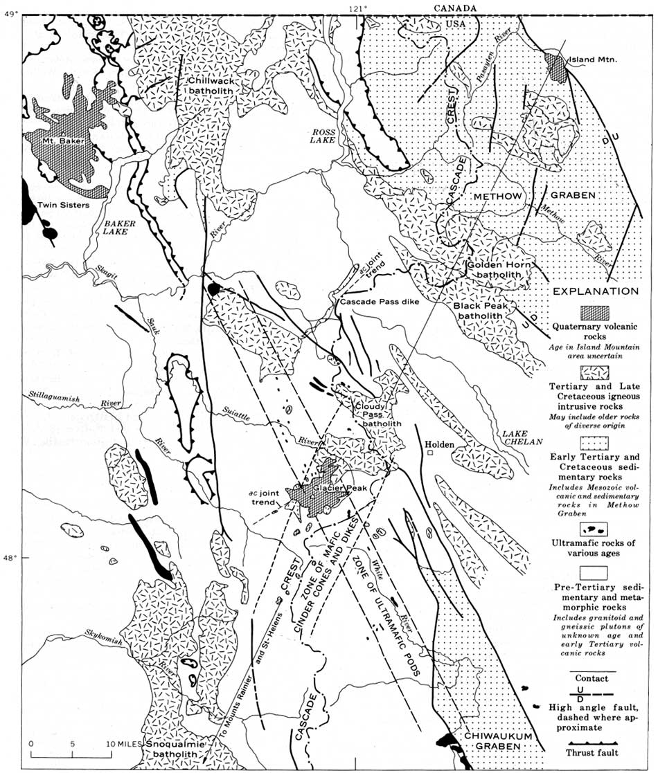
The ascending magma of the presently exposed part of the Cloudy Pass batholith appears to have been guided along three structural features (fig. 60): (1) Northwest-trending foliation, compositional layering, and fold axes of metamorphic rocks, (2) northwest-trending high-angle faults associated with the Chiwaukum graben (Cater, 1969, p. 5-6), and (3) a northeast-trending local structure defined by the alinement of steep-walled satellitic dikes and stocks (cupolas) west of the White Chuck River and the westward projection of the Sitkum stock. A large dike at Cascade Pass (Tabor, 1963, p. 1205) and many late Cenozoic dikes in the Glacier Peak-Lake Chelan area have a similar northeasterly trend (Cater and Crowder, 1967; Cater and Wright, 1967; Crowder and others, 1966). This northeasterly trend may be caused by joints perpendicular to regional fold axes (ac joints).
|
| FIGURE 60.—North Cascades showing major intersecting structures in the area of the Cloudy Pass batholith and Glacier Peak volcano. In the Glacier Peak area, data is from "Geologic Map of Washington" by Huntting (1961) and is modified according to figures 2 and 52; east of Holden, according to Cater and Wright (1967); north and northwest of the Cloudy Pass batholith, according to Tabor (1961), and Libby (1964) and Grant (1966) (see fig. 2); in the Methow graben, according to unpublished U.S. Geological Survey data; and in the area north of the Skagit River, according to Misch (1966). Data for the mafic cinder cone and dike belt from figure 52. Small ultramafic pods north of the Suiattle River from Bryant (1955, p. 49) and along the White River from Van Diver (1964, pl. 2). (click on image for an enlargement in a new window) |
The Glacier Peak volcano and the volcanic rocks of Gamma Ridge lie on the intersection of the northwesterly foliation and layering and the northeasterly ac joints. In addition, two other lineaments intersect beneath the volcanic center (fig. 60): (1) A northwestward-trending zone of small pods of serpentinized ultramafic rock, and (2) the zone of basaltic dikes and cinder cones that trends north-northeast (fig. 52). The zone of ultramafic pods also appears to be of regional extent and may, as elsewhere (for example, Irwin, 1964, p. C7; Misch, 1966, p. 120), mark a major dislocation. There is no other evidence of a major rupture under Glacier Peak, though the ultramafic pods near Leavenworth are along a Chiwaukum graben fault (fig. 60)—a fault active in late Cenozoic time (Willis, 1953, p. 795; Cater, 1969, p. 5-6)—and older faults near the White River (Van Diver, 1964, p. 124; 1967, p. 135). More data are needed to establish the regional extent of the zone of basaltic eruptive rocks, but it appears to include other Tertiary batholiths, such as the Golden Horn and Snoqualmie plutons and the volcanic centers of Island Mountain to the northeast and Mount Rainier and Mount St. Helens to the southwest. Perhaps the zone is a surface expression of a deep fracture zone which has led basalt magma to the surface. The same zone could have influenced the emplacement of the magmas of both batholith and volcano, no matter what their ultimate source.
| <<< Previous | <<< Contents >>> | Next >>> |
/pp/604/sec5.htm
Last Updated: 28-Mar-2006