
|
Geological Survey Professional Paper 604
On Batholiths and Volcanoes—Intrusion and Eruption of Late Cenozoic Magmas in the Glacier Peak Area, North Cascades, Washington |
DEVELOPMENT OF THE GLACIER PEAK SCENE
POSITION OF THE CASCADE CREST
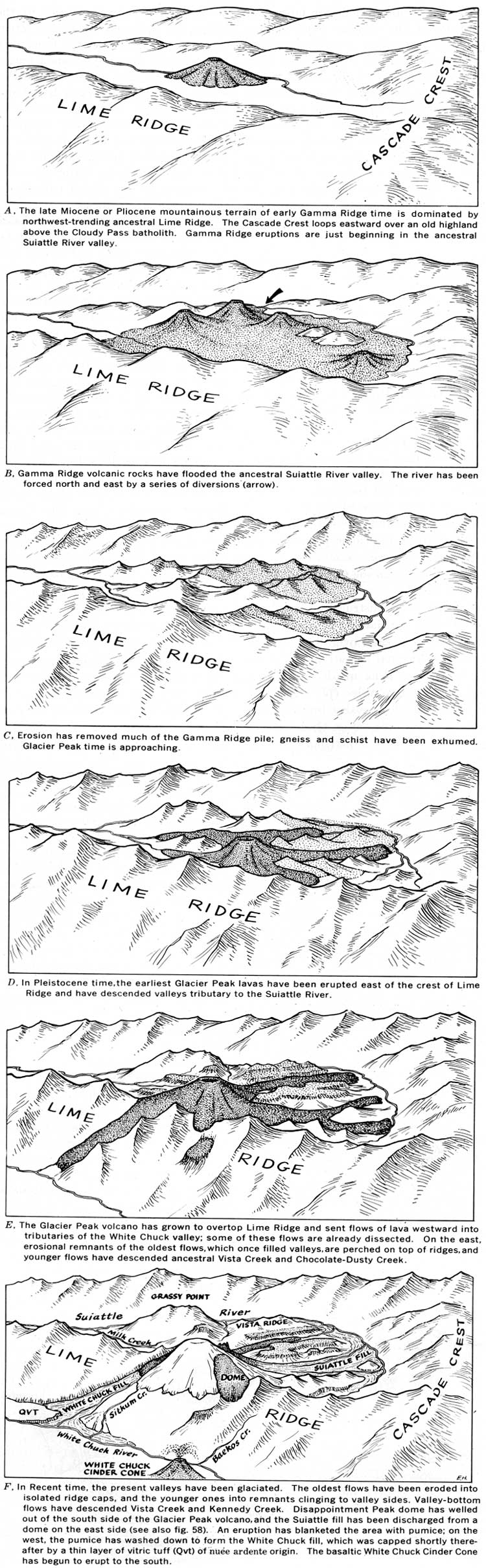
The physiographic history of the Glacier Peak area is depicted in figure 57. The North Cascades were certainly high prior to Gamma Ridge time, because the Columbia River, which was forced against the Cascade foothills by floods of late Miocene to early Pliocene plateau basalt, had to flow far to the south before it could again turn westward to the sea (Mackin and Cary, 1965). Today the Cascade Crest trends nearly due north for 80 miles and swings eastward only in the Glacier Peak area (fig. 60). This eastward loop at first glance appears to be the result of a divide migration caused by the growth of the Glacier Peak-Gamma Ridge eruptive piles. However, there is no evidence that the headwaters of the east-flowing streams have been captured or that their profiles are truncated at headwaters; barbed tributaries are absent on west-flowing streams like Triad and Small Creeks (see pl. 1 and Cater and Crowder, 1967). Although the Suiattle River was pushed eastward by the growing Gamma Ridge eruptive pile (see below), the eastward loop of the crest appears to have already existed before Gamma Ridge time. The eastward migration of the crest from a straight northerly course across an eastern upland may have been caused by doming over the Cloudy Pass batholith in early Miocene time.
|
| FIGURE 57.—Historical development of the Glacier Peak scene. (click on image for an enlargement in a new window) |
THE GAMMA RIDGE ERUPTIONS AND
RESULTANT DRAINAGE CHANGES
Gamma Ridge rocks were erupted west of the Cascade Crest onto a mountainous terrain (fig. 57A) as shown by the high relief preserved under them. Total buried relief is nearly 4,000 feet, but part of this could be due to post-Gamma Ridge deformation, or concurrent valley cutting and eruption. At Cool Glacier, the local relief under the Gamma Ridge volcanic rocks is 600 feet within half a mile, and in places north of Gamma Creek the local relief is 300 and 500 feet. It is unlikely that post-Gamma Ridge deformation would affect estimates of relief that are based on points so close together; thus, we assume that the buried terrain had a local relief of at least 600 feet and that many local slopes were as steep as those of the mountains today. The pre-Gamma Ridge landscape was dominated by northwest-trending valleys and ridges parallel to the grain of the bedrock, a trend well established, in the Washington Cascades as early as the Oligocene. (Mackin and Cary, 1965, p. 12-13.).
We have not been able to reconstruct the details of the topography onto which the Gamma Ridge volcanic rocks poured nor to determine their overall, extent and continuity. However, the original overall extent of the volcanic field in the Glacier Peak quadrangle might have been as much as 40 square miles (pl. 1), as suggested by the distribution of intrusive breccias that may be the feeders (for example, as on Grassy Point and near the Cool stock) and by the distribution of the five erosional remnants of the field itself.
The conspicuous loop of the Suiattle River around the apron of extrusive rocks of Glacier Peak and Gamma Ridge is manifestly due to stream diversion around the eruptive center (fig. 57B). Below the mouth of Milk Creek, the Suiattle River flows in a northwesterly course parallel to the crest of Lime Ridge and the trend of bedrock structures, as do most master streams. Above Milk Creek, the river begins the loop where it abruptly enters a gorge north of Grassy Point (pl. 1). The oldest Glacier Peak lavas (for example, those capping Vista Ridge and Gamma Ridge) extend radially from the summit region of Glacier Peak northeastward nearly to the present course of the Suiattle River, which indicates that the river was near its present position at the beginning of Glacier Peak time. Thus, the major diversion of the Suiattle River must be due almost entirely to the eruption of the Gamma Ridge rocks.
Gamma Ridge rocks occur on basement rocks along the Suiattle River at Lyman Camp (and not far above it on Gamma Creek) and nearly 4,000 feet above the river at the Cool Glacier and in upper Milk Creek. This altitude difference may be attributed to down-cutting by the river as it was diverted eastward around the growing Gamma Ridge pile. The earliest Glacier Peak flows apparently ponded in valleys tributary to the river's present position; for they now hang high above it (1,200 feet, above on Vista Ridge). These tributary valleys formed at this higher level because the Suiattle River was overwhelmed by Gamma Ridge volcanic eruptions and the Suiattle River valley was partly filled with volcanic rocks. After Glacier Peak lavas flowed into tributaries, the fill was removed and the oldest Glacier Peak lavas were left hanging.
An alternate hypothesis, more compatible with the supposition that Gamma Ridge rocks are much older Miocene extrusives from the Cloudy Pass chamber (fig. 26), is that the Gamma Ridge rocks occur at their present low level and are preserved because they were downwarped or downfaulted relative to older rocks on the high ridges to the east and west. As the details of the structure of Gamma Ridge rocks are unknown, except for a few steep dips observed locally, there is little direct evidence for folding or depression. However, folding along northwest-trending axes has been a dominant and continuous process in western Washington since early Tertiary time (Mackin and Cary, 1965), and post-Miocene folding along these trends has occurred to the southeast, on strike with the rocks of the upper Suiattle River area (Waters, 1932, p. 623). Furthermore, the easternmost of the many faults that border the Chiwaukum graben in the Holden quadrangle (Cater amid Crowder, 1967; fig. 60) project through the westernmost edge of the Gamma Ridge pile. There are no faults recognized here, and there is no direct evidence of movement as late as late Miocene or Pliocene along mapped faults.
THE GLACIER PEAK ERUPTIONS AND
RESULTANT DRAINAGE CHANGES
Initial eruptions of Glacier Peak lavas also took place in rugged mountains 2,000 to 3,000 feet below adjacent ridgetops (fig. 57D). The amount of relief is estimated from the difference in altitude between the base of Vista Ridge flows at 3,550 feet and the highest nearby remnants of older rocks such as Grassy Point at 6,505 feet. When eruptions began, the relief must have been greater still, for the lava-covered terrain has been protected from ensuing erosion while high ridges of basement rock without protective cover have been eroded an unknown amount. The volcano is perched on Lime Ridge (Carithers, 1946, p. 31), and Ford (1959, p. 312) estimated the maximum relief of the original terrain by noting the present relief of Lime Ridge, 4,500 feet. Except for a fault in Gamma Creek, we have found no evidence of deformation since the beginning of Glacier Peak eruptions; the estimated relief is therefore erosional not structural.
The basement rocks of Lime Ridge disappear under lava flows high on the volcano at altitudes near 8,000 feet, about 1,000 feet above the average height of Lime Ridge where flows are not present; doubtless the overlying volcanic rocks have protected the ridge from erosion. The oldest flows, of the volcano, the ridge-capping flows, are no older than 700,000 years. Those protecting the high rise of Lime Ridge are somewhat younger, for as shown below, the volcano did not begin to erupt on the ridge crest. The minimum rate of ridge-top erosion is thus 1,400 feet per million years. A comparable minimum rate of stream valley lowering calculated from the perched flows above the Suiattle River valley (as at the end of Vista Ridge and Gamma Ridge) is 1,700 feet per million years.
We find little evidence that the area covered by flows from the volcano was ever significantly larger than that covered today, although other workers (Carithers, 1946, p. 31; Ford, 1959, p. 266, 317) have inferred it to have been considerably larger. The broad glacier-blanketed area south of the volcano is anomalously high and might be considered to have been once protected by a lava apron. But since there are no lava outliers here, this area probably represents a highland near the Cascade Crest that prevented flows from traveling far southward. Ford (1959, p. 317) implied that this highland area was covered with lavas, because he considered a small mass of dacite on it to be a remnant of a flow. We think the same mass to be a dike because of its steep contacts. The many projections of lava that extend from the summit cap (for example, north of Gamma Creek and around the head of Milk Creek) are not remnants of a significantly larger cone, but instead are remnants of narrow valley-filling flows (fig. 57D and E). The long, flat spurs, one of which is capped by a dacite outlier, border the East Fork of Milk Creek and probably exist because they once had a protective cover of lava.
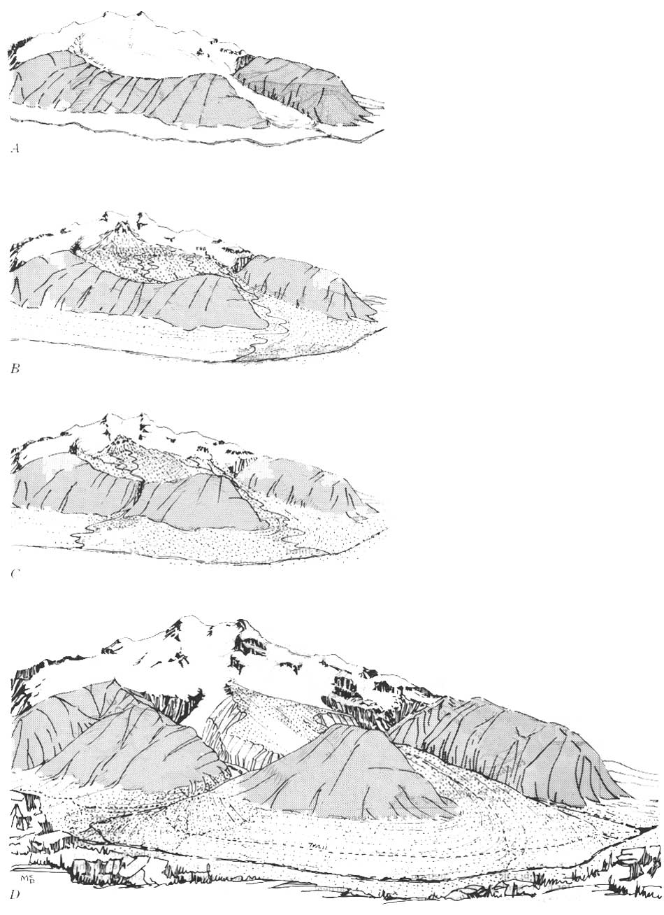
The Glacier Peak eruptive pile, as a whole, is clearly on the east side of Lime Ridge; this means that the earliest flows moved eastward toward the ancestral Suiattle River (fig. 57D). Thus, the ridge-capping flows on the east (for example, the ridge-capping flow on Gamma Ridge) are older than the ridge-capping flows on the west (for example, the ridge-capping flow in upper Baekos Creek). Those on the west had to await the growth of the volcano before they could flow down the west side of Line Ridge (fig. 57E). The local master streams (for example, the Suiattle River), being near, the sea and being well supplied with water during moist and glacial periods (Crandell, 1965, p. 342), were probably never far from grade. The continual erosion, as indicated by the successively older flows occurring at successively higher altitudes, must be due to a continual uplift during Glacier Peak time. Flows in valleys forced the streams aside; here they cut down, eventually leaving the flow perched on the valley wall (fig. 57E and F). The growth of the Suiattle fill forced the Suiattle River farther east and created Chocolate Creek (fig. 58). The construction of the White Chuck fill after the pumice eruption 12,000 years ago forced the White Chuck River to its western bank.
|
| FIGURE 58.—Development of the fill of the Suiattle River valley. A, Chocolate-Dusty Glacier in an ancient valley. B, Glacier retreat; volcanic debris, washed down from a rising dome, builds up fill. C, Ancestral Chocolate Creek spills in falls over saddle in confining ridge. Streams begin eroding fill when volcanic activity wanes. Some lavas extruded on fill. D, Renewed volcanic activity builds up more fill and chokes gorge cut by Chocolate Creek. Today, Chocolate Creek has cut a gorge again. Dusty Creek, hugging Gamma Ridge, also has cut deeply into the fill. Recently Dusty and Chocolate glaciers entered these valleys. (click on image for an enlargement in a new window) |
Today's streams have cut into the youngest valley flows. Erosion is rapidly removing the cone, which is high standing and heavily glaciated. The fractured lavas and unconsolidated valley fills are more easily eroded than the surrounding ridges of metamorphic and granitoid rocks. Cleavers of lava stand several hundred feet above the glaciers. Continuing floods of debris from Chocolate and Dusty Creeks (fig. 59) keep the Suiattle River pinned to its eastern bank.
|
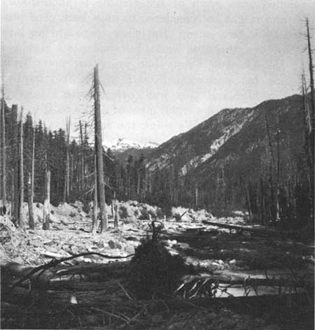
| FIGURE 59.—Forest buried in recent flood deposits along the Suiattle River near the mouth of Dusty Creek. Adamellite of the Cloudy Pass pluton exposed on timbered hillside in middle distance. |
| <<< Previous | <<< Contents >>> | Next >>> |
/pp/604/sec4.htm
Last Updated: 28-Mar-2006