
|
Geological Survey Professional Paper 604
On Batholiths and Volcanoes—Intrusion and Eruption of Late Cenozoic Magmas in the Glacier Peak Area, North Cascades, Washington |
LATE EPISODE OF VOLCANISM: GLACIER PEAK VOLCANO AND ASSOCIATED ROCKS
(continued)
PETROLOGY OF THE GLACIER PEAK LAVAS
(continued)
OTHER VOLCANIC ROCKS NEAR GLACIER PEAK
WHITE CHUCK CINDER CONE
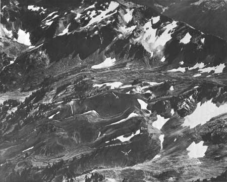
The White Chuck Cinder Cone, discovered by Everett Houghland in 1934 at the head of the White Chuck River (fig. 50), was first noted in print by Carithers (1946, p. 31). Ford (1959, p. 299-306) was the first to describe it in detail. It is composed primarily of red, black, and brown basalt lapilli and a sprinkling of scoriaceous and ropy bombs. Stream gullies near the center of the cone reveal a rude stratification of the pyroclastc rocks—alternating fine ash and coarser scoriaceous basalt lapilli in layers from 2 to 18 inches thick. Two basalt lava flows, locally separated by as much as 100 feet of cinders, crop out around two-thirds of the cone's base in cliffs 10 to 30 feet high. The flows have crude columnar joints and grade upward into highly vesicular aa tops.
|
| FIGURE 50.—View of the eroded White Chuck Cinder Cone from the northwest. Central part of cone is in lower left of view. Note the thin lava flows cropping out interbedded with cinders (A) and the fresh moraine overlying the upper edge (B) of the cone. Photograph by Austin Post. |
Ford (1959, p. 300) thought that the main cinder cone was little eroded and that the small central hill was a younger spatter cone. Our findings suggest that the cinder cone has been much dissected and central hill is an erosional remnant of one side cone. The flanks of the cone have been cut back, especially on the side overlooking the White Chuck. The steep-sided pile of bare cinders locally known as The Cinder Cone is also an erosional remnant on the ridgelike rim of the breached cone; there is no evidence here of a subsidiary vent. The location of the actual crater of the White Chuck Cinder Cone is unknown, but it may well lie toward the center of the erosional remnants and may be filled with rubble.
The cone lies at the edge of a glacier-carved cirque and interrupts the smooth concavity of the cirque; it therefore was built after the latest Pleistocene alpine glaciation during which this cirque was formed—the Evans Creek Stade (Crandell, 1965, p. 344), about 17,000 to 21,000 years B.P. However, a small fresh moraine lies on the cinders on the western edge of the cone. Clearly this moraine was deposited by a more recent glacier, presumably one that occupied the cirque 2,000 to 3,500 years ago during the so-called Little Ice Age of the Cascades (Matthes, 1942; Crandell and Miller, 1964, p. D110), or possibly by a still younger glacier. The considerable erosion of the cinder cone suggests that it is much older than 2,000 years B.P.
Ford (1959, p. 307) found no Glacier Peak pumice on the cone. As we previously described (p. 45), we found one location where a highly weathered yellow pumice overlies basaltic cinders and is overlain by a thin white ash. The source of the weathered yellow pumice is unknown, because its high refractive index (fig. 47, No. 15) differs significantly from that of the Glacier Peak pumice, but the overlying white ash may be the Mount Mazama ash of 6,600 years B.P. We conclude that the White Chuck Cinder Cone is certainly younger than 17,000 years B.P. and older than 2,000 years B.P., and it is possibly younger than 12,000 years B.P. and older than 6,600 years B.P.
In the high-alumina olivine basalt flows of the White Chuck Cinder Cone (sample 21, table 4), small (0.1-0.3 mm) rare phenocrysts of olivine (forsterite-rich) and plagioclase (andesine-labradorite) swim in a felty mat of small plagioclase laths. The spaces between plagioclase microlites are filled with very small crystals of olivine, pyroxene (?), an opaque mineral, and minor glass. In contrast, the basalt scoria (sample 22, table 4) is mostly black glass with rare microphenocrysts of olivine and plagioclase.
INDIAN PASS CINDER CONE
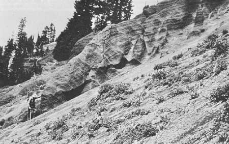
The Indian Pass cinder cone is less well exposed than the White Chuck Cinder Cone. Erosion has reduced it to a circular mound on the south slopes of Indian Head Peak and to reworked (?) rubble underlying Indian Pass about one-fourth mile south of the southern limit of the map area (plate 1). The sides of gullies reveal a rude stratification of the pyroclastic rocks—alternating fine ash and coarser scoriaceous basalt lapalli—in layers 2 to 18 inches thick. Well-stratified beds of tuff and breccia are fairly well consolidated; they dip steeply southward approximately parallel to the slope (fig. 51), which suggests that the crater of the cone was upslope to the north on the side of Indian Head peak (Ford, 1959, p. 304). The degree of lithification of the cinders suggests that the cone was large. The ejecta consist mostly of light-brown to black, scoriaceous basalt lapilli, 1/2 to 2 inches in diameter, which differ little from those of the White Chuck Cinder Cone.
|
|
FIGURE 51.—Stratified basaltic cinder deposits of the Indian
Pass cinder cone just north of Indian Pass. Cascade Crest just to
right. |
The Indian Pass cinder cone appears to be younger than the last major glaciation. Ford (1959) suggested that it is older than the White Chuck Cinder Cone because of its greater erosion, but its location on a steep hillside could account for this.
An olivine basalt dike found in one place in the compacted cinders was probably one of the feeders (sample 20, table 4). It is much like the flows of the White Chuck Cinder Cone, though it contains more and larger phenocrysts of plagioclase. It is more alkalic than most high-alumina basalt (Kuno, 1960). Granules of opaque grains and pyroxene occur in the groundmass.
DISHPAN CAP CINDER CONE
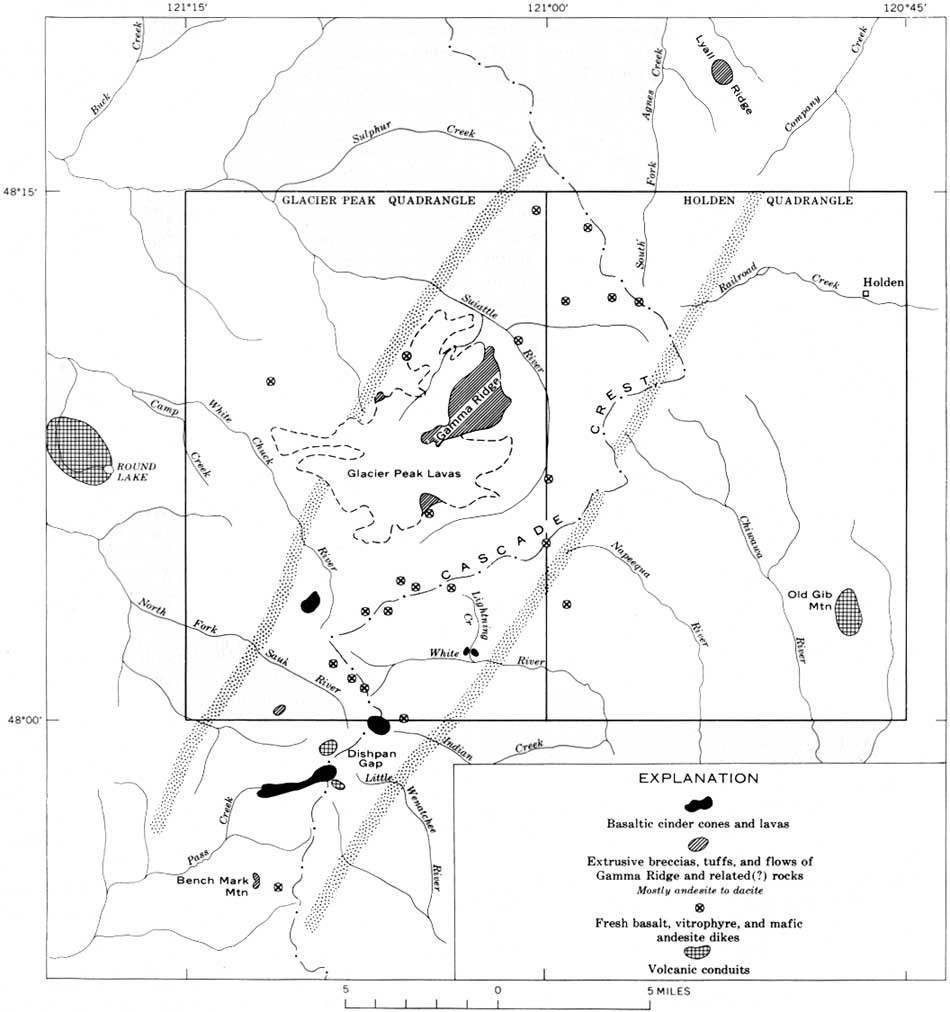
Just south of Indian Pass at Dishpan Gap (fig. 52), Rosenberg (1961, p. 94-96) reported another basaltic cinder cone. Areal photographs reveal a lava flow along upper Pass Creek that was probably derived from it. The obvious constructional form of the flow supports Rosenberg's contention that the cinder cone is relatively young.
|
| FIGURE 52.—Sketch map showing distribution of volcanic rocks, fresh andesitic and basaltic dikes, and probable volcanic conduits. Basaltic eruptive rocks and dikes are concentrated in a northeast-trending zone between the stippled lines. Data south of the Glacier Peak quadrangle, from Rosenberg (1961, p. 83-96, pl. 11) and Oles (1957, p. 183-188, pl. B); west of the Glacier Peak quadrangle, from Vance (1957, p. 288-289, pl. 1); and north of the Holden quadrangle from Libby (1964, p. 118-119, pl. 27). (click on image for an enlargement in a new window) |
FLOW OF LIGHTNING CREEK
At the mouth of Lightning Creek, a flow of olivine andesite underlies a bench that slopes gently valley-ward about 150 to 200 feet above the White River. The flow has been breached by Lightning Creek, and the two remnants face the White River with an erosion scarp which prominently displays vertical columns, 1/2 to 2-feet thick. Fracture zones, probably related to cooling, cut the columns and parallel the bottom contact of the flow, which also dips valleyward.
The lava apparently flowed into the glacial-carved White River valley, although subsequently the White Chuck Glacier may have advanced enough to erode the flow. Thus, the age of the flow might be somewhat close to that of the valleyside-clinging flows of Glacier Peak that also lie in glaciated valleys, but it could be considerably younger.
The rock of the flow is black and dense and its texture is intergranular to intersertal. It is rich in phenocrysts of olivine (forsterite-rich), oscillatorily zoned labradorite, and smaller clinopyroxene crystals. Plagioclase laths, clinopyroxene, opaque granules, and rare brown glass make up the groundmass. Chemically, it is more like an andesite than a basalt (sample 23, table 4; fig. 30).
The source of the andesite flow is unknown. Its presence at the mouth of Lightning Creek suggests it came down the creek. A probable feeder on the west rim of the Lightning Creek cirque is a prominent spine of andesite (sample 25, table 5), the erosional remnant of a large dike. The flow and the dike have similar chemical composition. Another possible source is a basalt dike at the head of the White River (sample 24, table 5) though it is chemically dissimilar to the flow. If either dike was the feeder, it is remarkable that no remnants are found between them and the flow remnant on Lightning Creek.
DIKES
We have not identified with certainty any dikes cutting the lavas of the Glacier Peak volcano. This is surprising, considering that other workers have found feeder dikes on the flanks of many Cascade volcanoes and one would not expect the eruptions at Glacier Peak to have been confined entirely to the central vent. However, there are numerous medium-grained, fine-grained, and aphanitic dikes exposed in the metamorphic and granitic rocks around the volcano. These dikes include basalt, microdiorite, dacite and rhyodacite porphyries, and fine- to medium-grained hornblende and biotite-hornblende diorites. Various highly altered dikes contain calcite, sericite, chlorite, and epidote minerals and locally have relict volcanic textures; some of these altered dikes could be related to Gamma Ridge volcanic rocks.
Of special interest are the fresh basaltic and andesitic dikes concentrated in a northeast-trending belt that includes the three basaltic cinder cones already discussed; this belt trends under the Glacier Peak volcano (fig. 52). The basaltic and andesitic dikes in this belt (samples 24-26, table 4) are conspicuously fresh, and many are tens of feet thick and form prominent ribs or spires. They generally trend northeastward (see Crowder and others, 1966). Nothing is known of the possible existence of dikes or extrusive rocks southwest of Bench Mark Mountain (fig. 52), but Grant (1966, p. 250) mentioned the occurrence of numerous fresh aphanitic dikes along the northeast strike of the belt. Workers elsewhere in the region surrounding the Glacier Peak area (Vance, 1957; Bryant, 1955; Libby, 1964; Adams, 1961; Tabor, 1961) reported no basaltic extrusive rocks or dikes other than those shown in figure 52.
OTHER CENTERS OF VOLCANISM
Several workers have described centers of volcanic activity near Glacier Peak (fig. 52). The conduit at Round Lake described by Vance (1957, p. 288-289) has been mentioned in the section on Gamma Ridge eruptive rocks. The Old Gib, a volcanic neck of probable Eocene age at Old Gib Mountain, has been described by Cater and Crowder (1967).
We found another probable volcanic neck and other evidence of an ancient volcano just north of the Dishpan Gap cinder cone, at the head of the North Fork of the Sauk River. A prominent rotten spine exposed here consists of an inner core of altered porphyritic hornblende-pyroxene dacite separated from its glassy margin by a concentric zone of highly altered rock containing much montmorillonite. Drainages (fig. 52) radiate from the area of this spire, presumably because they are superposed from a volcano once located here. Other indications of an ancient volcano are: (1) The numerous hypabyssal bodies to the south of Dish Pan Gap mapped by Rosenberg (1961, p. 83-96), (2) a columnar-jointed mass south of the Dishpan Gap cinder cone, which Rosenberg considered to be another volcanic orifice, perhaps the feeder for the flow on Bench Mark Mountain described by Oles (1957, p. 183-188), and (3) a mass of volcanic rock about 2 miles to the northwest that might also be a lava-flow remnant. On the basis of its outcrop shape this lava-flow remnant was first interpreted as a thick dike (Crowder and others, 1966), but the facts that its columnar joints are nearly vertical and that it is permeated by montmorillonite as is the rock of the suspected conduit now suggest to us that it is a flow. Chemically (sample 27, table 4, and fig. 30) the flow remnant is more like the earlier lava flows of Glacier Peak or the analyzed Gamma Ridge rocks than the other analyzed dikes.
| <<< Previous | <<< Contents >>> | Next >>> |
/pp/604/sec3d.htm
Last Updated: 28-Mar-2006