
|
Texas Bureau of Economic Geology
Guide to the Permian Reef Geology Trail, McKittrick Canyon, Guadalupe Mountains National Park, Texas |
INTRODUCTION
Don G. Bebout, Charles Kerans, and Paul M. Harris
The Permian Reef Geology Trail in the mouth of McKittrick Canyon, Guadalupe Mountains National Park (fig. 1), traverses 610 vertical meters (2,000 ft, or 1,520 to 2,130 m [5,000 to 7,000 ft] topographic elevation) of Permian (upper Guadalupian) facies through one of the world's finest exposed examples of a rimmed carbonate platform margin. The present-day topography approximates that formed by the Capitan reef along the edge of the Delaware Basin. Encouraged by geologists from geological societies, universities, the petroleum industry, and the U.S. Geological Survey, the U.S. National Park Service constructed the Permian Reef Geology Trail (fig. 2) in the early 1980's to provide better access to the depositional facies and diagenetic features of this shelf margin.

|
| FIGURE 1. Map of the Capitan reef front, Guadalupe Mountains, and location of McKittrick canyon, other major canyons along the escarpment, Guadalupe Peak, and El Capitan. Modified from King (1948). |
|
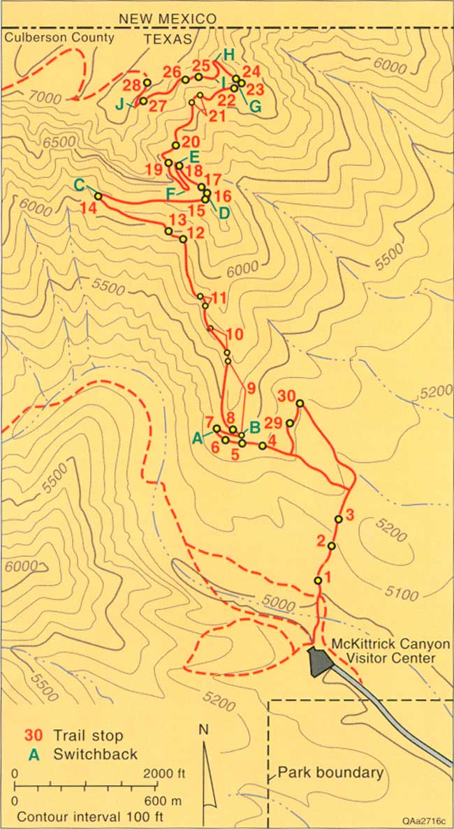
| FIGURE 2. Topographic map of the mouth of McKittrick Canyon showing the location of the Permian Reef Geology Trail and trail stops. (click on image for an enlargement in a new window) |
This trail guide provides detailed documentation of the carbonate facies encountered along the Permian Reef Geology Trail. Carbonate facies descriptions are most useful when they are integrated into the local and regional stratigraphic framework and into a shelf-to-basin depositional model, as was done herein. Assignment of specific depositional environments to many of the facies represented along the trail remains controversial; where this is true, an effort has been made to introduce alternative interpretations.
Geologic Setting
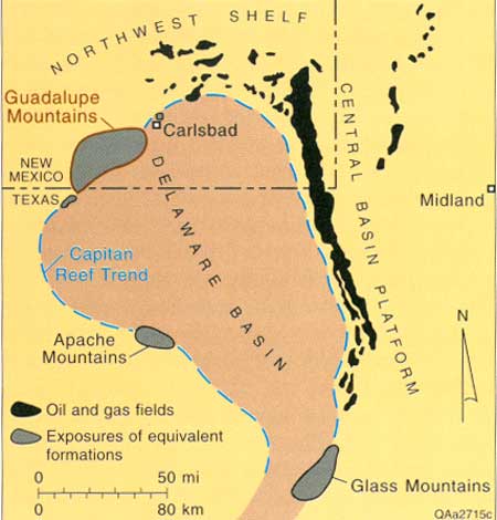
The Capitan reef and its associated upper Guadalupian carbonate platform define the margin of the Delaware Basin of West Texas and New Mexico (fig. 3). Equivalent units occur in the subsurface on the northern (Northwest Shelf) and eastern (western margin of the Central Basin Platform) sides of the basin, where sandstone shelf facies of the Capitan interval are reservoirs for oil and gas accumulations (fig. 3) (Ward and others, 1986). More than 1.6 Bbbl of oil has been produced from upper Guadalupian (Tansill, Yates, Seven Rivers, and Queen Formations) oil and gas reservoirs in West Texas and New Mexico (Holtz, 1991).
|
| FIGURE 3. Map of the Permian Basin showing the location of the upper Guadalupian reef trend, oil and gas fields producing from equivalent strata in the subsurface, and mountains with exposures of upper Guadalupian formations. Modified from Ward and others (1986). |
Most of the reef that rims the Delaware Basin is buried; however, Basin and Range-related tilted fault blocks in the Guadalupe, Apache, and Glass Mountains provide Capitan reef outcrops along parts of the western and southern sides of the basin. The Guadalupe Mountains exposures are the most accessible. The west flank of the southern Guadalupe Mountains is a fault scarp that exposes the reef and its basin equivalents in cross section view more than 300 m (>1,000 ft) in the vertical dimension and several miles in the dip dimension. The east side represents an erosionally modified depositional profile of the shelf-to-basin system that was exhumed during late Cenozoic uplift of the Mountains. Canyons, such as McKittrick Canyon, that cut into the platform give access to cross-sectional views. South of McKittrick Canyon, topset beds are largely eroded; north of McKittrick Canyon, most canyons do not incise deeply enough to expose bottomset beds. However, McKittrick Canyon exposes nearly the complete platform section.
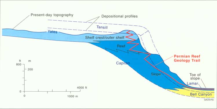
The Capitan reef is the youngest of a series of shelf-margin complexes developed around the Delaware Basin. The Capitan reef separates shallow-water deposits to the northwest from deep-water deposits to the southeast. The relatively narrow (16- to 24-km [10- to 15-mi] wide) carbonate facies tract is downdip of a much broader, restricted, evaporite and siliciclastic facies tract. The landward part of the carbonate tract is a broad (4.7- to 12.9-km-wide [6- to 8-mi]) belt of dolomudstones, dolowackestones, and skeletal and coated-grain grainstones deposited in very shallow water, restricted lagoons. The seaward part of the carbonate tract exposed along the trail consists of facies deposited in the following depositional environments: shelf crest and outer shelf, reef, slope, and toe of slope (fig. 7). Deep-water deposits southeast of the carbonate tract are siliciclastic coarse-grained siltstone to fine-grained sandstone with intercalated, basinward thinning limestone members of the Bell Canyon Formation, Delaware Mountain Group (fig. 4). Water depth in the basin near the shelf margin is estimated to have been approximately 550 m (~1,800 ft) during the latest part of Capitan deposition (Newell and others, 1953).
|
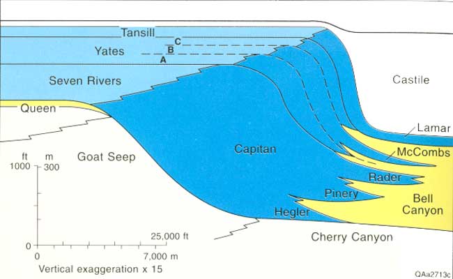
| FIGURE 4. Cross section showing shelf-to-basin correlations of the Capitan Formation and equivalents. Blue areas are dominantly carbonates and evaporites, and yellow areas are mostly sandstone. Modified from Garber and others (1989). (click on image for an enlargement in a new window) |
In the Guadalupe Mountain area, the Capitan shelf margin carbonates prograded 4.8 to 8 km (3 to 5 mi) to the southeast to form a thick sheetlike deposit parallel to the basin margin (Garber and others, 1989). After demise of the reef, the basin was filled with evaporites (and the shelf complex was buried) by latest Permian time. Evaporites were dissolved and the reef was exhumed during Pleistocene uplift (Bachman, 1976).
|
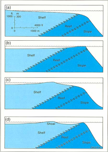
| FIGURE 5. Hypothetical paleobathymetric profiles across the Capitan shelf margin. (a) uninterrupted slope from shelf to basin (King, 1948). (b) Profile showing shoaling at shelf-margin barrier reef (Newell and others, 1953). (c) Profile showing shoaling at pisolite shelf crest landward of the reef (marginal-mound profile of Dunham, 1972). (d) Profile showing shoaling at Tansill-equivalent shelf-margin barrier reef and pisolite shelf crest (Kirkland-George, 1992). |
Many formation names have been applied to the rock units along a depositional profile across the Capitan shelf margin. King (1948) used "Capitan Formation" to refer to all massive carbonates separating Artesia Group shelf deposits from sandstones of the Bell Canyon Formation (fig. 4). Hayes (1964) divided the Capitan Formation into the Massive and Breccia members; Newell (1953) used the terms "reef" and "reef talus" for the same divisions. In this trail guide the terms "reef" and "slope" are used to informally subdivide the Capitan carbonates and minor siliciclastics. Shelfward equivalents of the Capitan Formation include the sandstones, carbonates, and evaporites of the Tansill (youngest), Yates, and Seven Rivers Formations (fig. 4). The shelf deposits are mixtures of carbonates, siliciclastics, and evaporites; the Yates Formation contains proportionately more siliciclastics, whereas the Tansill and Seven Rivers Formations are dominantly carbonate. Basinward equivalents are the siliciclastics of the Bell Canyon Formation, and along the edge of the basin, the Lamar (youngest), McCombs, Rader, Pinery, and Hegler carbonate members (fig. 4). The shelf carbonate units interfinger with the siliciclastic-dominated Bell Canyon of the basin center and provide key markers for linking shelf and basin strata.
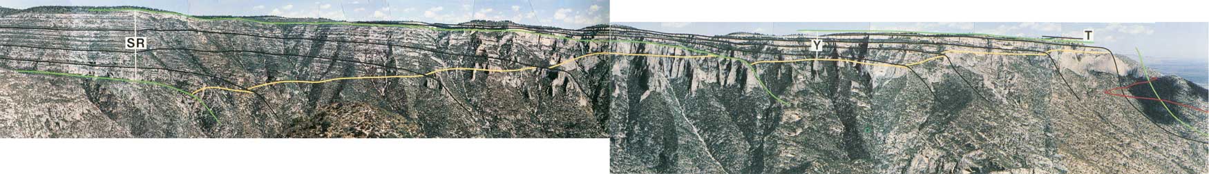
Several paleobathymetric profiles for the Capitan shelf margin have been proposed over the years. The uninterrupted slope model (fig. 5a) shows gradual deepening of water from the shelf into the basin. All other models suggest shallowing at the shelf margin to form a barrier reef (fig. 5b), or shallowing at a position landward of the reef where pisolite shoals define the shelf crest (fig. 5c), or both (fig. 5d). Examination of exposures along the north wall of McKittrick Canyon (fig. 6), in conjunction with work of Hurley (1977, 1989), demonstrates that the profile varied during deposition of the Capitan Formation. Hurley's (1977, 1989) examination of the lower portion of the Seven Rivers Formation documented 24 to 30.5 m (80 to 100 ft) of paleorelief between peritidal shelf-crest facies and the Capitan reef (fig. 5c) and called the intervening basinward-sloping shelf region the "outer-shelf fall-in beds" (Hurley, 1989, credits the term "fall-in" to L. C. Pray). This basinward slope, estimated at up to 8° (Hurley, 1989) of the outer shelf in the lower Seven Rivers Formation, can be clearly seen in figure 6. The Seven Rivers Formation is ~183 m (~600 ft) thick in this area, and the equivalent Capitan reef margin displays 2.4 km (1.5 mi) of progradation. None of the Seven Rivers equivalent Capitan Formation is exposed along the trail.
|
| FIGURE 6. Photomosaic of the north wall of McKittrick Canyon showing the Tansill (T), Yates (Y), and seven Rivers (SR) Formations (green lines); interpreted depositional profiles (black lines); transition between the outer shelf and reef (yellow line); and Permian Reef Geology Trail (red). Photo by F. J. Lucia. (click on image for an enlargement in a new window) |
Yates Formation platform profiles are markedly more flat-topped, as is demonstrated by tracing the distinctive recessive sandstone-rich intervals in the Yates Formation across the shelf. On the north wall of McKittrick Canyon (fig. 6) and in the subsurface (Borer and Harris, 1991) five packages, marked by sandstone beds at the base of each, are considered equivalent to Yates depositional sequences. The upper three packages equate to the Yates A, B, and C divisions of Newell and others (1953) (fig. 4). However, only the youngest two sequences of the Yates Formation (Yates B and C) are exposed on the trail. The Tansill Formation is preserved as a small erosional remnant at the crest of the north wall of the Canyon (figs. 6 and 7). The trail intersects 21 m (70 ft) of the Tansill Formation, which is the Tansill's total thickness in the canyon. Erosion has removed all Tansill-equivalent Capitan reef and most of the slope, leaving only the deeper slope record of the Lamar Limestone Member of the Bell Canyon Formation exposed on the lower third of the trail (fig. 7). Bedding configuration and facies along the upper part of the Permian Reef Geology Trail suggest a Yates profile with a shelf crest coincident with the tepee-pisolite facies tract and an outer-shelf seafloor sloping seaward toward a deeper water reef, like that shown in figure 5c.
|
| FIGURE 7. Diagrammatic sketch of the north wall of McKittrick Canyon showing the stratigraphy, depositional environments, present-day erosional profile, and general location of the Permian Reef Geology Trail. (click on image for an enlargement in a new window) |
The Trail
The remainder of this guidebook is a detailed description and discussion of the facies exposed along the trail (fig. 2). However, the trail crosses only a very small part of the entire Capitan reef complex exposed in McKittrick Canyon (figs. 6 and 7). In addition, postdepositional erosion and cover limit somewhat the continuity of the outcrop along the trail. Erosion has removed all of the Tansill- and uppermost Yates-equivalent reef and most of the Tansill shelf strata. Vegetation and present-day talus cover parts of the upper-slope section, particularly in the critical reef-transition areas, making correlation of these steeply dipping beds difficult. Note also that the slope of the trail is less than both the depositional slope and present-day topographic slope; therefore, facies encountered along the trail are not all from time-equivalent units. For example, along the slope and reef parts of the trail, one encounters progressively older slope facies while walking farther along (up) the trail. The trail traverses facies of the toe-of-slope in Stops 1-8, 29, and 30; slope in Stops 9-14; reef in Stops 15-22; and outer shelf/shelf crest in Stops 23-28 (figs. 2 and 7).
Detailed examination of all stops in this guide will require 2 days. For a 1-day trip, use the guide to select (approximately half) those stops of particular interest to you or your group. The length of the trail is ~5.6 km (~3.5 mi); the vertical climb is 610 m (2,000 ft). As a general guide for a 1-day trip, plan to cover the lower part of the trail (up through Stop 18) by noon and the upper part (to the top) by 2 p.m. Allow 1.5 to 2 hours for return to the McKittrick Canyon Visitor Center at the bottom. Note that gate-closure times are posted at the McKittrick Canyon road entrance. Elevation markers have been installed every 30 m (100 ft) vertically along the trail to provide reference for location of stops (fig. 2). Most markers are located on the uphill side of the trail, generally in an easily visible position ~0.3 to 0.6 m (~1 to 2 ft) above the trail.
Do not disturb or remove any rocks, plants, or wildlife, and do not leave the trail. Hammers and other sampling equipment may not be carried on the trail. These activities are prohibited by law. The important features described in this guide are all well displayed on natural and blasted rock faces visible from the trail. In addition, a collection of rock samples used to prepare this guide has been provided to the park museum study collection and is available through prearrangement at the Headquarters Visitor Center Building 19.3 km (12 mi) south of McKittrick Canyon.
| <<< Previous | <<< Contents >>> | Next >>> |
state/tx/1993-26/intro.htm
Last Updated: 2-Apr-2007