
|
Texas Bureau of Economic Geology
Guide to the Permian Reef Geology Trail, McKittrick Canyon, Guadalupe Mountains National Park, Texas |
TOE OF SLOPE
Alton Brown and Robert G. Loucks
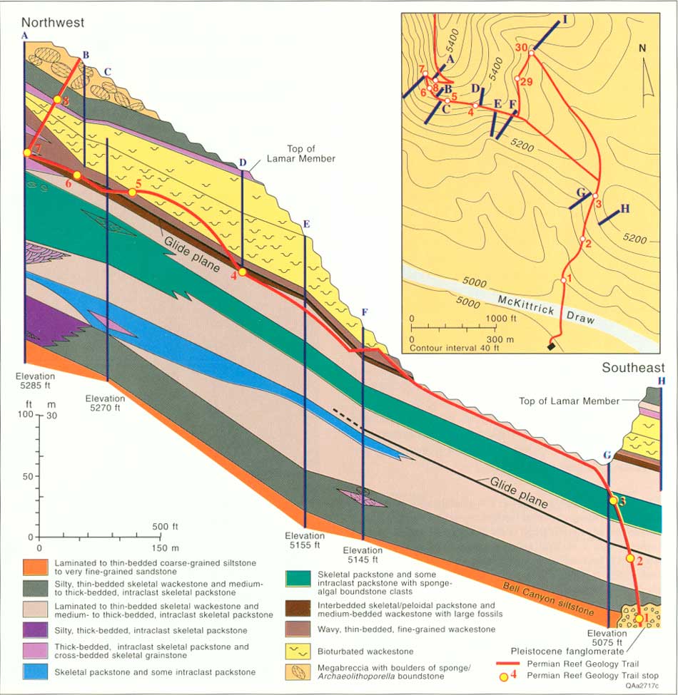
Rocks exposed along the lower part of the trail are toe-of-slope facies of the Lamar Limestone Member of the Bell Canyon Formation. The toe-of-slope environment occurs where the low depositional dip characteristic of the basin increases to the higher dip characteristic of the slope. The increase in dip is associated with decreasing carbonate mud content and increasing bed thickness. These and other facies changes in the toe of slope can be examined along a time line, because Stops 4-7 expose the same approximate stratigraphic level (fig. 8). Toe-of-slope depositional processes changed during Lamar deposition, so a single time slice, such as observed along this part of the trail, does not exhibit the full variety of lithologies and facies relationships found here. Additional cross sections and overviews fill this gap by illustrating these relationships and providing a stratigraphic framework for interpreting larger scale processes.
|
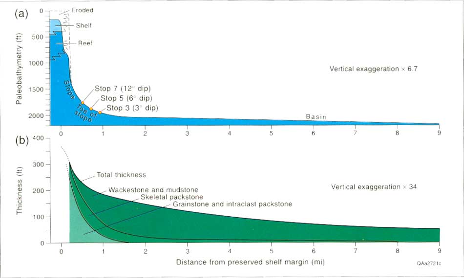
| FIGURE 8. Dip-oriented, structural cross section of the toe-of-slope Lamar Limestone exposed on the north wall at the mouth of McKittrick Canyon. Units of Lamar Limestone Member of the Bell Canyon Formation shown on the section generally become more thin bedded and less grainy down paleoslope. Inset shows location of the stratigraphic sections measured for this trail guide. The red line marks the approximate position of the trail on the cross section, and circles mark the position of stops. (click on image for an enlargement in a new window) |
The Permian Reef Geology Trail starts on the north side of McKittrick Draw, at the canyon side of the McKittrick Canyon Visitor Center. The trail begins at a fork to the right at the Park Service sign ~46 m (~150 ft) beyond the draw.
STOP 1. Quaternary-Age Alluvial Conglomerate
The cliff at the start of the trail exposes Quaternary age, calcite-cemented alluvial-fan conglomerate consisting of well-rounded limestone clasts with calcilitharenite matrix. The 5,000-ft elevation marker is located on this exposure. Depositional-flow units are generally less than 1 m (<3.3 ft) thick; cobbles in the coarser units average 20 cm (7.9 inches) long with single boulders up to 50 cm (19.5 inches) across. Large pebbles are locally imbricated. A modern analog of these deposits is the gravel of McKittrick Draw. Bachman (1976) dated eroded Guadalupian conglomerates as middle to late Pleistocene, prior to the present downcutting cycle. The conglomerates form a superficial cover over the Bell Canyon siltstones and lowest part of the Lamar for the next few hundred feet along the trail.
STOP 2. Distal Toe-of-Slope Wackestone
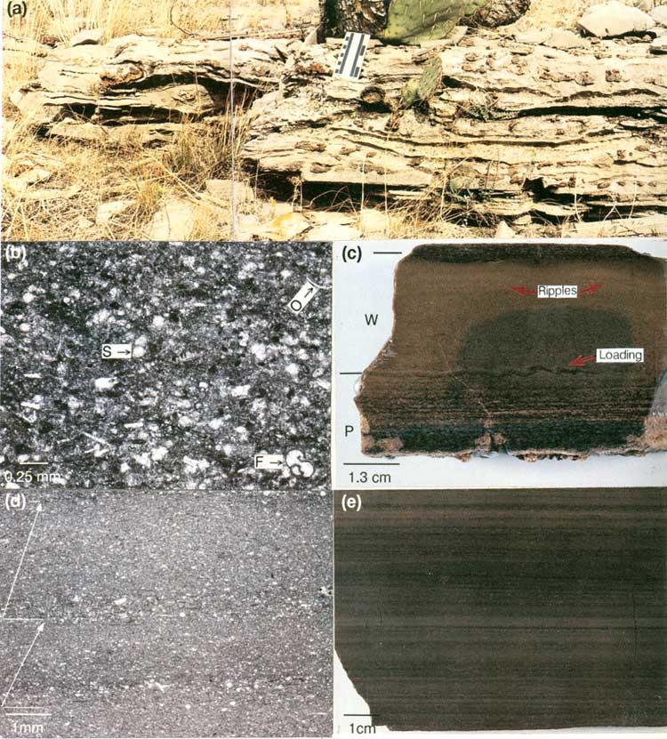
Stop 2 is 229 m (750 ft) uptrail from Stop 1 in the lower part of the Lamar. Stop 2 is identifiable by the resistant 3-m-thick (10 ft), cherty limestone bed exposed to the right of the trail (fig. 9a). The dominant lithology at this stop is dark-gray, laminated to thick-bedded skeletal-peloidal wackestone. Most grains in the wackestone are coarse-silt to fine-sand sized (fig. 9b), so the limestone appears to be a mudstone in outcrop. Microfossils are those characteristic of the slope setting, such as foraminifers, spicules, ostracodes, calcispheres, and fragments of larger fossils such as thin-shelled brachiopods. Silicified brachiopods, bryozoans, horn corals, and other body fossils are common in some beds. Fossil constituents and depositional texture are similar to the toe-of-slope wackestones throughout the toe-of-slope section.
|
| FIGURE 9. Stop 2, trail and thin-section photographs: (a) outcrop photo of cherty, slump-contorted wackestone near the base of Stop 2, (b) thin-section photomicrograph of skeletal peloidal packstone grading upward into a skeletal peloidal wackestone grains include ostracodes (O), foraminifers (F), sponge spicules (S), and peloids (dark colored clots), (c) polished slab (scale bar = 1.3 cm [0.5 inch]) of a thin-bedded limestone showing thin, partially silicified, basal packstone (P) and an overlying graded wackestone (W); the packstone has parallel laminations and the wackestone has load-induced structures and faint ripples near the top and a concentric color pattern caused by weathering, (d) photomicrograph of laminated, normally graded, skeletal (small white specks) wackestone; horizontal lines show base of graded units and arrows show upward-grading, skeletal composition similar to that of figure 9b, (e) polished slab of laminated wackestone. (click on image for an enlargement in a new window) |
Beds immediately below the silicified limestone are dominantly thin- to medium-bedded limestones. Many thin-bedded limestones have a 1.3-cm-thick (0.5 inch), basal, laminated, skeletal packstone unit overlain by graded, skeletal-peloidal wackestone with faint parallel laminations and rare, low-relief ripples that are visible only on polished slabs (fig. 9c). These features suggest deposition by turbidity current.
The cherty limestone bed (fig. 9a) has a distinctive convoluted structure caused by proximity to a syndepositional slide. High chert content may be related to the abundance of sponge spicules in this bed. Light-colored, red-weathering silica is common in toe-of-slope wackestones and packstones.
The limestone above the silicified bed is laminated wackestone interbedded with thin-bedded wackestone and skeletal packstone. Each lamina consists of 0.3 to 0.5 mm of wackestone to packstone that grades upward into 2 to 4 mm of wackestone (fig. 9d and 9e). The laminae are interpreted to be low-density turbidity-current deposits. A sparsely burrowed laminated bed about 0.3 m (1 ft) thick occurs about 3 m (10 ft) upsection from the silicified bed. Just below this bed, the laminated wackestone is recumbently folded by syndepositional slope failure. The nose of the fold plunges southeastward, almost directly down paleoslope.
A 1-m-thick (3-ft) erosionally resistant wackestone overlies the laminated wackestone about 4.6 m (15 ft) upsection from the silicified bed. Although grain types are similar to those in the other wackestones, this anomalously thick bed has a faintly convoluted fabric. This unit is tentatively interpreted as a matrix-rich debris flow in which the dominant intraclasts were stiff muds.
For the next 46 m (150 ft), the trail intersects thin-bedded skeletal wackestones interbedded with thin packstone beds. Feeding traces and silicified fossils are exposed on excavated blocks along the trail.
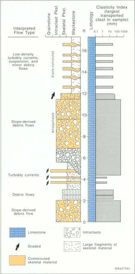
STOP 3. Distal Toe-of-Slope Debris-Flow
Deposits
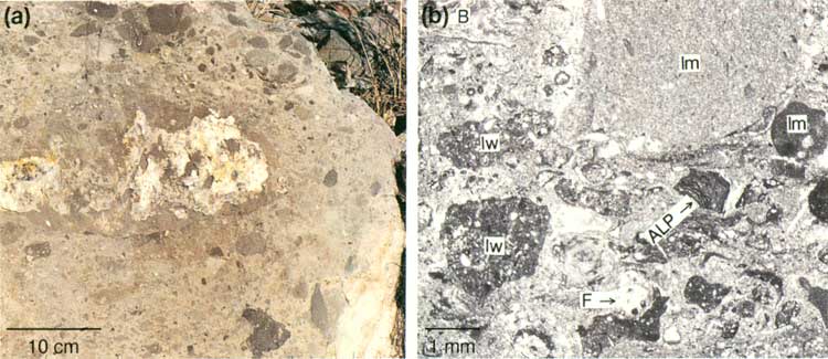
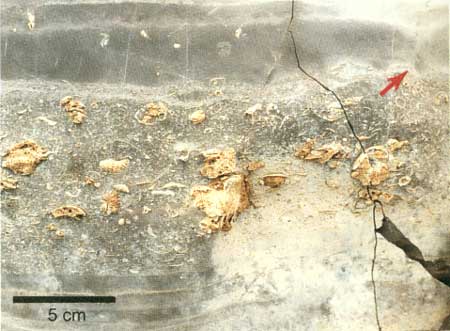
The trail cuts two prominent, erosionally resistant beds separated by about 1.5 m (5 ft) of section just below the crest of the first low ridge (see fig. 8 inset for location). Stop 3 contains one of the few stratigraphic intervals rich in thick- and medium-bedded intraclast and skeletal packstones this far from the reef. Although large clasts are mudstones, wackestones, and packstones derived from the slope (fig. 10a), small clasts of sponge-algal boundstone occur in the intraclast packstones, indicating that this flow was derived from high on the slope (fig. 10b). These packstones are interpreted to have been deposited by debris flows and high-density turbidity currents (fig. 11). Chert bodies in these beds are diagenetic features, not depositional clasts.
|
| FIGURE 10. Stop 3, trail and thin-section photographs: (a) outcrop photograph (scale = 10 cm [4 inches]) of the intraclast skeletal packstone at the middle of Stop 3; large clasts are mudstone, wackestone, and packstone pebbles to cobbles derived from the lower slope; Archaeolithoporella boundstone is represented as sand- and granule-sized clasts, (b) thin-section photomicrograph (plane-polarized light) of an intraclast skeletal packstone. Skeletal grains include brachiopods (B) and foraminifers (F); intraclasts include Archaeolithoporella boundstone (ALP), skeletal/peloidal wackestone (lw), and mudstone (lm). (click on image for an enlargement in a new window) |

|
| FIGURE 11. Stop 3, measured section with interpreted depositional processes. Position of laminated wackestone and thin skeletal packstone beds in the upper part of the section is schematic due to poor exposure. |
The junction of the Geology Loop Trail (straight) and the Permian Reef Geology Trail (sharp left) is marked by a sign. The Geology Loop Trail exposes depositional-strike-oriented facies changes in the toe-of-slope setting. These stages are described in a separate section beginning on page 44.
The Permian Reef Geology Trail continues up a dip slope in the upper part of the Lamar Limestone Member following the crest of the low ridge separating McKittrick Canyon from drainage to the northeast (fig. 8 inset). The flaggy bedded laminated wackestones exposed along the ridge crest in the vicinity of the 5,200-ft elevation marker are similar to those discussed at Stop 2. Above the upper junction with the Geology Loop Trail, the Permian Reef Geology Trail follows the base of a low cliff. Echinoid spines, gastropods, and scaphopods are common on some bedding planes of the thick-bedded wackestones exposed on the trail just before the Grottos (Stop 4).
STOP 4. Vertical and Lateral Changes in
Toe-of-Slope Sedimentation
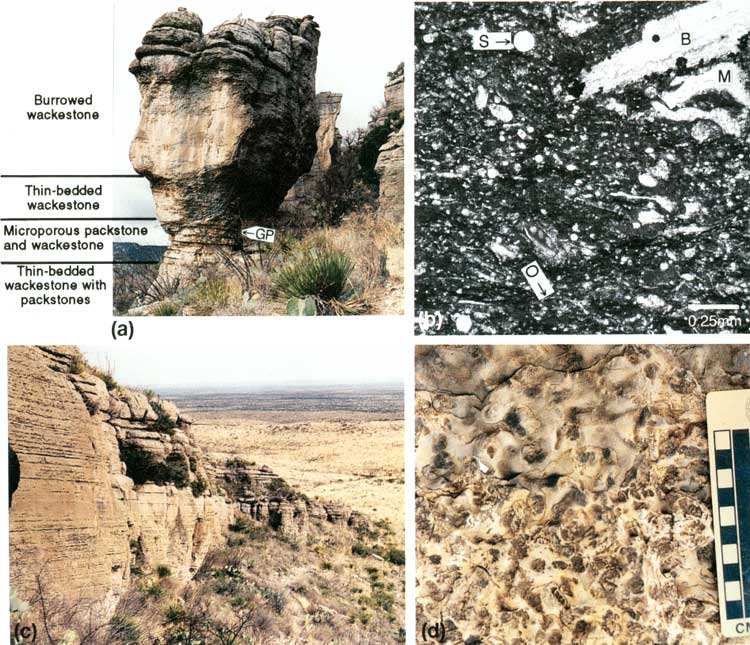
Farther along the trail are shady, protected areas called the Grottos. Stop 4 is located at the down-trail end of the Grottos. Limestones exposed at Stop 4 are predominantly very fine grained wackestones and mudstones with skeletal constituents similar to those described at Stop 2. Four stratigraphic units are exposed here (fig. 12a); these units can be traced along the cliff downdip and updip from Stop 4 (fig. 12c) and to the cliff on the south side of McKittrick Canyon. The lowest unit is a thin-bedded, fine-grained wackestone with thin skeletal packstone layers similar to rocks at Stop 2. Overlying this lower unit is a recessively weathered unit of microporous, coarse skeletal-peloidal packstone (fig. 12b) interbedded with medium-bedded wackestone with large fossils. Because of its recessively weathered profile and unique lithology, this unit forms a key correlation bed with Stop 7 and measured sections even farther updip and downdip. This unit is separated by a paleoglide plane from the third unit, a thin-bedded, sparsely bioturbated, fine-grained wackestone. The upper two-thirds of the cliff is a wackestone with a characteristic bioturbated fabric (fig. 12d). Most burrows are unbranched, oblique to horizontal, tortuous, smooth-walled, cylindrical traces. Observed characteristics are similar to the form ichnogenus Planolites.
|
| FIGURE 12. Stop 4, trail and thin-section photographs: (a) outcrop with unit marked GP identifying paleoglide zone, characterized by bedding convolution, separating two of the units, (b) thin-section photomicrograph of microporous peloidal packstone with grains of brachiopods (B), sponge spicules (S), ostracodes (O), and mollusks (M) and dark matrix including many deformed peloids, (c) view along the Lamar cliff of burrowed wackestone from Stop 4 showing continuity of bedding and preserved depositional dip, (d) outcrop of weathered bedding plane of the Planolites-burrowed wackestone. (click on image for an enlargement in a new window) |
The lower three units are interpreted to be low-density turbidity current deposits with different fractions of coarser material. Depositional mechanism of the upper unit is unknown. Variations in burrow intensity record changing biological activity in the toe-of-slope setting. Absence of bioturbation indicates anoxic conditions in the Delaware Basin, whereas extensive bioturbation indicates dysaerobic to aerobic conditions (Babcock, 1977). This burrowed wackestone has been correlated about 8 km (5 mi) into the basin and onto the slope (Stop 10), so it may mark a major incursion of oxygenated water into the otherwise anoxic Delaware Basin (Babcock, 1977).
The upslope change from laminated wackestone, as observed at Stop 2, to thin-bedded wackestone, here at Stop 4, is one of many changes in the Lamar Limestone Member that reflects proximity to the shelf margin. The paleoslope steepens dramatically from the basin to the toe of slope (fig. 13a). The Lamar interval thickens, and the percentage of grainy facies increases (fig. 13b). The scale of changes is best appreciated by looking toward the basinal Lamar outcrops here. Although there is a northeasterly structural dip of about 2° in the originally flat-lying basin units, their dip in the paleoslope direction (southeast) is less than 13 m per 1.6 km (<70 ft/mi), so present-day dip measured perpendicular to the platform margin closely approximates that of depositional slope. The distant cuestas to the southeast are almost directly down paleoslope from McKittrick Canyon. They are capped by a thin (9- to 12-m-thick [30- to 40-ft]) section of Lamar wackestones and mudstones. Just outside the park, near the mouth of McKittrick Canyon, the low hills expose more than 46 m (>150 ft) of limestone, but depositional dip is gentle, and the Lamar Limestone is still more than 95 percent wackestone. From this point, paleoslope steepens, and the fraction of grainy rocks increases significantly. Depositional dip increases from ~3° at Stop 3 to an average of 6° at Stop 4 (fig. 13a).
|
| FIGURE 13. Regional variations along a reef-to-basin cross section of (a) depositional dip and (b) lithology and thickness of the Lamar Limestone Member. The reconstructed paleobathymetry of the top of the Lamar Limestone Member is based on modern structural relief and assumes no compaction. The top of the Lamar is correlated with the base of the Ocotillo Member of the Tansill Formation about 61 m (200 ft) above the base of the Tansill. Lithology and thickness data are from measured sections in Tyrrell (1962), Babcock (1977), and this study. (click on image for an enlargement in a new window) |
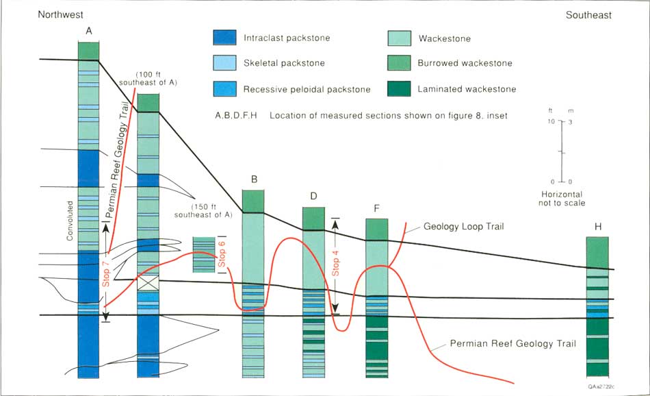
Updip from the Grottos, paleoslope steepens, and the fraction of grainy limestone greatly increases. Stops 4, 6, and 7 expose the same stratigraphic interval in different paleobathymetric positions (fig. 14). The slightly burrowed, thin-bedded wackestone above the recessively weathered peloidal packstone at Stop 4 contains no skeletal packstone beds. At Stop 6 the same unit has numerous thin skeletal packstone beds, and at Stop 7 the same unit is thicker and contains thick intraclast packstone beds (fig. 14).
|
| FIGURE 14. Cross section of toe-of-slope facies between Stops 4 and 7 along the north wall of McKittrick Canyon. Wackestone units vary systematically from laminated in downdip sections to thin-bedded in updip sections. Skeletal packstones thicken and become more abundant up paleoslope, and intraclast packstones are present in the sections proximal to the shelf margin. (click on image for an enlargement in a new window) |
STOP 5. Stratigraphic Relations on the South
Side of the Canyon
Outcrops at the second Grotto are more weathered and poorly exposed, but updip thickening and lithology changes in the toe-of-slope setting can be examined in the Lamar exposed in the cliff on the south wall of the canyon (fig. 15). At first glance, the beds in the upper half of the cliff appear to downlap onto beds in the lower half of the cliff. Closer inspection of bedding relationships indicates an overall thinning in a downdip direction, but no single downlap surface. Convergence of bedding is caused by thinning and termination of individual beds. There are two prominent bedding-termination surfaces that are planar, basinward-dipping surfaces of onlap, which truncate underlying, shallow-dipping beds (fig. 15). These surfaces are interpreted to be glide planes wherein intact sections of overlying strata slid basinward as subtle slumps, but they may represent large-scale scour-and-fill structures. The upper, continuous recessively weathered unit corresponds to the recessively weathered unit here and at Stop 4. Stop 5 approximately corresponds to a paleobathymetric position near the southeast end of the cliff, whereas Stop 7 corresponds to a position to the right of the large pine tree at switchback A.
|
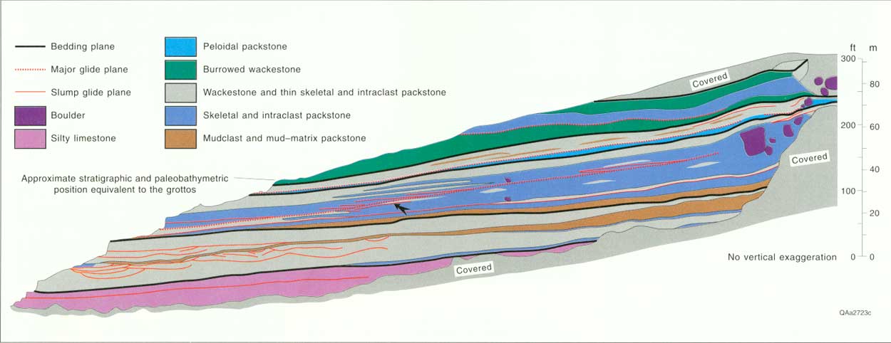
| FIGURE 15. Interpretation of lithology and bedding relationships on the cliff of Lamar Limestone on the south side of McKittrick Canyon (Stop 5). Large boulders and packstones occur in the updip part of the cliff. Packstones terminate downdip by thinning of the debris-flow depositional units and by glide-plane truncation (large arrow). Thin wackestone beds were deformed and eroded by the debris flows, and slumps in the lower part of the cliff are at the same stratigraphic position as the deformed wackestones at Stop 2. Lithology in the central part of the cliff is interpreted from weathering patterns and correlation to the ends of the cliff. Beds are thin and variable in the central part of the cliff, so the lithology shown there is schematic. Area of outcrop shown in figure 16. (click on image for an enlargement in a new window) |
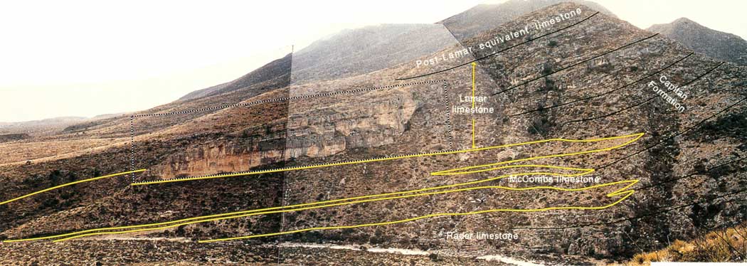
Stratigraphic relationships between basin and slope beds can also be viewed on the south wall of McKittrick Canyon (fig. 16). The Bell Canyon siliciclastic members are the vegetated, tan-to-yellow slopes. The McCombs, Lamar, and Rader Limestone Members of the Bell Canyon Formation weather into resistant white or gray beds. These carbonate members thicken and merge updip with the lower part (slope) of the Capitan Formation as the siliciclastic members thin.
|
| FIGURE 16. Photograph of the south wall of McKittrick Canyon across from Stop 5 showing the basinal carbonate members merging with the Capitan Limestone. The transition from updip carbonate to downdip siltstone is shown with the yellow lines; the black lines mark bedding within the limestone. The area of figure 15 is outlined by the dashed line. Stratigraphic relationships after Newell and others (1953). (click on image for an enlargement in a new window) |
STOP 6. Turbidites and Debris-Flow Deposits
Stop 6 is about 46 m (150 ft) beyond the end of the cliff, past a clump of low trees. The low exposures on the north side of the trail are thin- to medium-bedded, homogeneous, fine-grained wackestone containing thin-bedded 5- to 15-cm-thick (2- to 6-inch) packstone beds with skeletal fragments up to 1.3 cm (0.5 inch) across (fig. 17). The same stratigraphic interval at Stops 4 and 5 lacks packstones and has less depositional slope (fig. 13a). Some packstones are ungraded; others are normally or inversely graded. Fossils within the packstones are brachiopods, bryozoans, and foraminifers, all of which are characteristic of slope settings. Some wackestone beds show boudin structures (fig. 17). Contacts between the grainy and muddy units are slightly convoluted. Convolution and boudin structures are thought to be caused by creep associated with incipient slope failure of muddy sediment on these steeper paleoslopes. The wackestones are interpreted to be low-density turbidity-current deposits, whereas the graded packstones are interpreted to be suspension layers within high-density turbidity current deposits (53 layers of Lowe, 1983). The ungraded packstones are either debris-flow or high-density turbidity current deposits.
|
| FIGURE 17. Photograph of ungraded skeletal packstone along the trail at Stop 6. The large siliceous bodies in the center of the bed are diagenetic, not transported clasts. This bed is interpreted to be a slope-derived debris flow. The overlying wackestone has been deformed by boudins by downslope creep (red arrow). |
STOP 7. Transition from Toe of Slope to
Slope
The updip transition from units dominated by thin-bedded wackestones (toe of slope) with thin skeletal packstones to units dominated by thick, mud-clast-rich packstones (slope) is exposed at Stop 7 at switchback A (fig. 18a). The cut at the switchback exposes a thick-bedded, erosionally resistant packstone and an underlying, recessively weathered, thin-bedded, peloidal packstone with thin peloidal-skeletal grainstone beds (fig. 19). This is the same peloidal packstone unit that occurs at Stop 4, but at Stop 7 the unit contains thin grainstone beds (fig. 18b) and megafossil packstone beds instead of wackestone beds with megafossils as at Stop 4. The thicker packstone bed is amalgamated from three flows; the lowest is rich in wackestone clasts, the middle unit is rich in brachiopods (fig. 18c), and the upper unit is a mixture of constituents of both the lower and middle units. None of the units contain clasts with boundstone fabric or reef organisms, indicating that these intraclast packstones were derived from the slope. The base of the amalgamated packstone cuts into the underlying recessive packstone at the switchback. Surrounding units and depositional interpretations are shown in figure 19.

|
| FIGURE 18. Stop 7, trail and thin-section photographs: (a) stratigraphic section around Stop 7 showing the downdip thinning of intraclast packstone units (yellow) that cross the trail (dashed), amalgamation surfaces (red), and truncation of units underlying packstone (red arrows); (b) peloidal-skeletal grainstone from recessively weathered packstone and grainstone interval with mollusk fragments (M), smaller fusulinids (F), algal/foraminifer coated grains (C), peloids (P), and ostracodes (O); (c) skeletal-intraclast packstone from the middle member of the amalgamated debris flow at Stop 7 with brachiopods (B) and mud intraclasts (I). (click on image for an enlargement in a new window) |
|
| FIGURE 19. Measured section at Stop 7 with depositional interpretations. The switchback intersects the section 1 m (3 ft) above the base of the section, at the base of a recessively weathered peloidal packstone interval. Abbreviations and symbols are the same as those in figure 4, except for the peloidal packstone interval, which is plotted with the wackestones. |
The stratigraphic relationships at this transition are as important as the suite of sedimentary structures. The intraclast packstones maintain approximately the same thickness updip from switchback A, yet they abruptly thin and terminate in a relatively short distance down paleoslope from the switchback (figs. 14 and 18a). This transition is also visible on the upper part of the cliff on the south side of the canyon.
Up the trail from switchback A are poorly exposed thin- to medium-bedded wackestones with thin, skeletal packstone beds and other intraclast packstones. The burrowed wackestone exposed in the path about 46 m (150 ft) up the trail from switchback A is correlative with the burrowed wackestone unit at Stop 4.
STOP 8. Top of Lamar Limestone Member
Stop 8 is at a resistant-weathering, thick, intraclastic packstone bed with large wackestone clasts and muddy skeletal matrix stratigraphically above the burrowed wackestone, about 30 m (100 ft) uptrail from switchback A (fig. 2). The packstone is interpreted to be another slope-derived, debris-flow deposit. Overlying thin-bedded mudstones contain flat bivalve fossils and a small amount of quartz silt along dolomitic partings. These units are interpreted to be low-density turbidity current deposits. The packstone bed is interpreted to be the top of the Lamar Limestone Member of the Bell Canyon Formation. The overlying, slightly silty (quartz) mudstones and thin-bedded wackestones are in the post-Lamar member of the Bell Canyon Formation (fig. 8). This silty interval also correlates to the silty interval in the slope near Stop 12.
Summary
The dominant lithology exposed along the lower part of the trail is very fine grained, laminated to thin-bedded, skeletal wackestone with thin layers of skeletal packstone. Most of these units were deposited by low-density turbidity currents. The deposits are best interpreted as a type of periplatform ooze in which clay- and silt-sized carbonate was derived from the shallow-water shelf, and the coarse silt and larger skeletal grains and intraclasts were derived from the slope.
Three types of grainy limestones are exposed along the trail in the toe of slope: (1) thin 1.3-cm to 25-cm thick (0.5 inch to 10 inches) packstone and graded grainstone beds containing slope-derived skeletal material, (2) thick (25-cm to 10-m thick [10 inches to 4 ft]) pebble to cobble conglomerate beds with a packstone fabric and slope-derived wackestone clasts and skeletal grains, and (3) channelized, thick to very thick bedded, pebble to cobble conglomerates with a packstone matrix and clasts derived from both the shelf margin and slope.
At the same paleoslope position, some stratigraphic intervals are characterized by abundant packstones, whereas other intervals are dominated by wackestones (fig. 8). This pattern indicates that toe-of-slope deposition alternated between deposition of carbonate-mud-rich, low-density turbidity current deposition and grain-rich, debris-flow and high-density turbidity current deposition. Most tongues of thick, coarse-grained, slope-derived intraclast packstones do not extend as far basinward as do tongues containing the channelized packstones derived from the shelf margin (fig. 8). The slope-derived gravity flows apparently had less momentum than the gravity flows generated at the shelf margin.
In contrast to the abrupt downdip termination of the intraclast packstones, the skeletal packstones thin as they interfinger downdip with the thin-bedded and laminated wackestones (fig. 14). This intetfingering indicates that the debris flows and high-density turbidity currents that deposited the skeletal packstones changed downslope into low-density turbidity currents that deposited the thin-bedded and laminated wackestones farther down-slope.
| <<< Previous | <<< Contents >>> | Next >>> |
state/tx/1993-26/sec1.htm
Last Updated: 2-Apr-2007