
|
Texas Bureau of Economic Geology
Guide to the Permian Reef Geology Trail, McKittrick Canyon, Guadalupe Mountains National Park, Texas |
SLOPE
Denise Mruk and Don G. Bebout
The slope is a transitional depositional/physiographic region between the shallow-water carbonate shelf and the deep-water toe of slope and basin. Slope deposits reflect this transition and record components of two basic end-member sedimentary processes: gravity-induced flows from outer-shelf, reef, and slope environments and suspension sedimentation of the basin. Transport mechanisms characteristic of the slope include rock-fall, slump, grain-flow, high-density turbidity current, and debris-flow. Deposits formed by each of these processes will be examined in slope outcrops exposed along the Permian Reef Geology Trail.
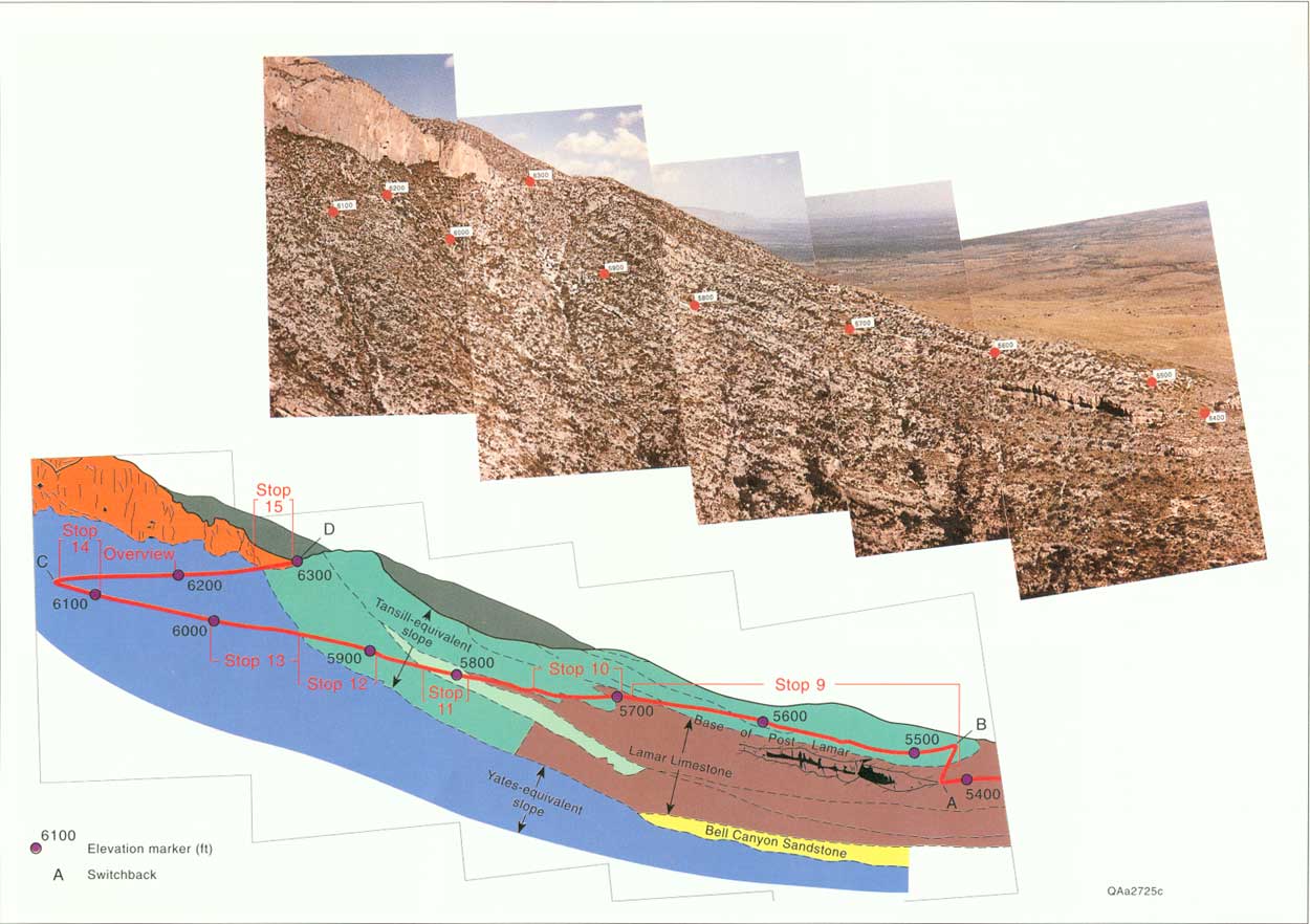
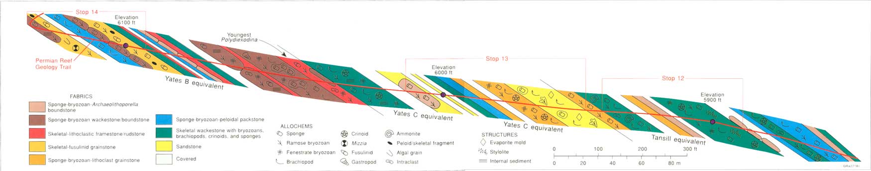
The slope facies tract of the Capitan Formation is discussed at seven locations (stops) along the trail from just below switchback B to switchback D (fig. 20). The present structural dip, which approximates the depositional dip of the Permian slope beds, is steeper than the slope of the trail; therefore, younger rocks are exposed along the lower part of the trail, and older rocks along the upper part. Tansill-equivalent slope facies are exposed at Stops 9-12. The Tansill-equivalent reef facies have been eroded in McKittrick Canyon; therefore, the only preserved reef facies are in debris-flow blocks in the Tansill-equivalent slope beds. Yates-equivalent outcrops are exposed at Stops 13 and 14. The Yates-equivalent slope beds correspond to the massive reef facies and lower two-thirds of the shelf beds exposed along the higher parts of the trail beyond switchback D (fig. 20).
|
| FIGURE 20. Dip-oriented oblique aerial photograph and an interpretive tracing of the slope and toe-of-slope portion of the Permian Reef Geology Trail. Locations of slope Stops 9-14, reef Stop 15, and elevation markers are noted along the trail. (click on image for an enlargement in a new window) |
STOP 9. Mud-Dominated Gravity-Flow Deposits
Tansill-equivalent, mud-dominated gravity-flow deposits are well exposed along the lower third of the slope part of the trail and are designated as Stop 9. Numerous examples of the very thick bedded, lithoclast megabreccias are exposed from ~30 m (~100 ft) beyond switchback A up the trail to the 5,700-ft marker (fig. 20). The contact of the Lamar Limestone Member, described in the previous section of this guide, with the overlying slope megabreccias is identified by the change from thin-bedded, dark-colored, fine-grained limestone of the toe-of-slope and basinal facies to very thick bedded, light-colored, slightly silty, dolomitic wackestone of the megabreccia facies. Angular clasts 1 to 30 cm (0.4 to 12 inches) in diameter are incorporated within the dolomitic wackestone. Large, rounded boulders of sponge-Archaeolithoporella boundstone are at the contact on either side of the trail.
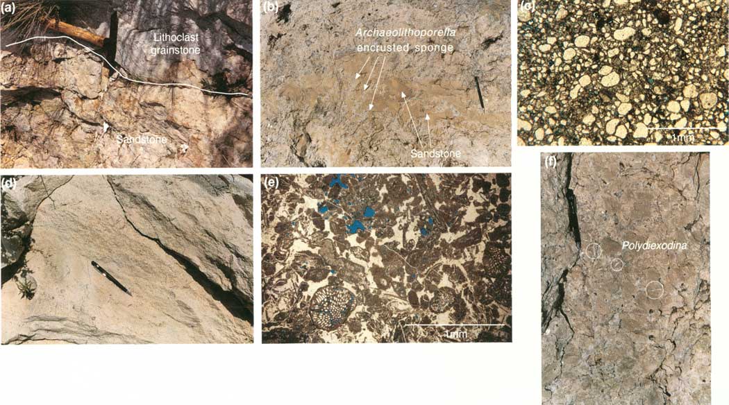
The megabreccia exposed at switchback B is part of a 24-m-thick (80-ft) amalgamated unit of alternating clast-supported and matrix-supported limestone beds (fig. 21a). Bedding within the amalgamated unit dips at 15° to 20°. Some beds demonstrate inverse grading from pebble-size clasts to boulder-size blocks. The clasts include reef-derived sponge-Archaeolithoporella boundstone (Toomey and Babcock, 1983), slope-derived skeletal wackestone and packstone, and dark-gray wackestone derived from the underlying toe-of-slope beds (fig. 21b). In the reef-derived blocks, the problematical alga Archaeolithoporella (fig. 21c) commonly encrusts small, elongate sponges; also present are brachiopod spines, the pinnate bryozoan Acanthocladia, and quartz silt. Brachiopods and crinoids in the matrix between the blocks may have been indigenous to the slope environment. Calcite-filled evaporite molds are visible in the sandy dolomitic wackestone below switchback B. The amalgamated unit exposed at Stop 9 is interpreted to represent repeated deposition by cohesive debris flows. Bedding planes within this unit probably indicate boundaries between individual debris flows. These debris-flow deposits overlie post-Lamar-age siltstone (fig. 20).
|
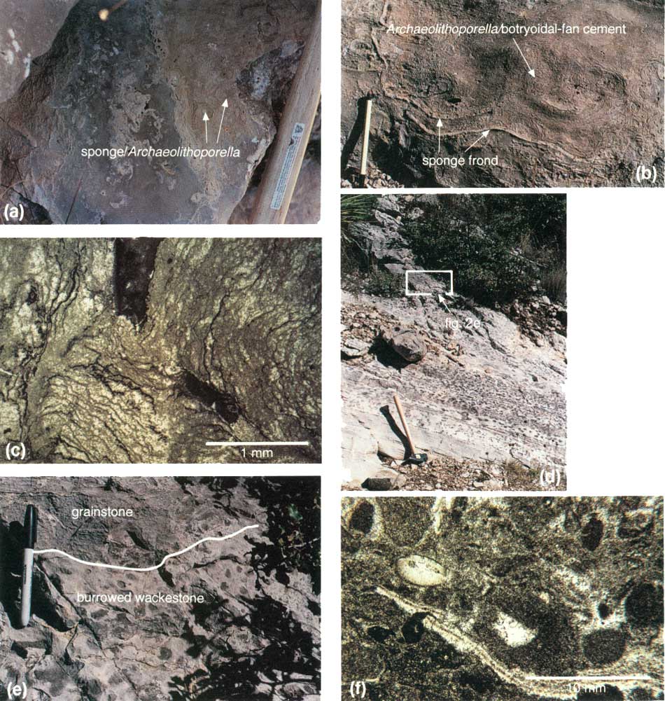
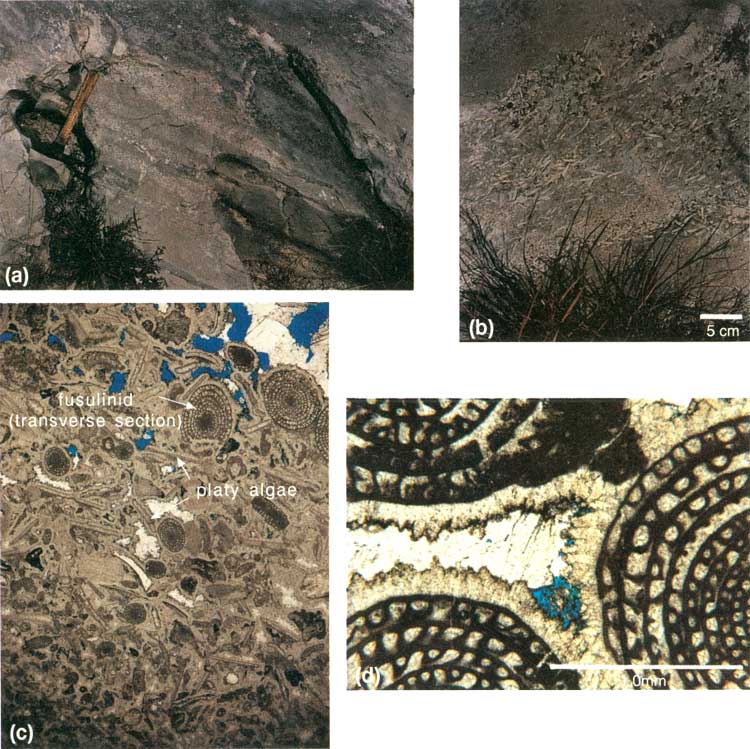
| FIGURE 21. Stop 9, trail and thin-section photographs: (a) sponges encrusted with Archaeolithoporella standing out in relief against the undolomitized skeletal-peloidal wackestone-packstone matrix; hammer handle on right side of photo for scale, (b) reef block with large sponge fronds and Archaeolithoporella and botryoidal-fan cement, (c) thin section of Archaeolithoporella showing the characteristic irregular, concentric laminations. Stop 10, trail and thin-section photographs: (d) toe-of-slope burrowed wackestone, with 20° dip, preserved between debris flows of the slope, (e) interpreted erosional contact between the wackestone and grainstone, (f) thin section of the burrowed wackestone showing abundant peloids. (click on image for an enlargement in a new window) |
Analysis of geopetal fabrics is one of the most useful tools for distinguishing between allochthonous reef blocks and autochthonous massive reef beds. Variously oriented geopetal structures occur within the reef blocks of the lithoclast megabreccias and indicate that the blocks were transported after initial deposition and early cementation.
The boundstone fabric in the reef blocks was formed in shallower water on the slope or shelf margin. Oversteepening of the reef as it extended over unstable upper-slope sediments resulted in mass slumping of reef material and transportation down the slope. The most distinctive features of the Tansill-equivalent reef facies are the lack of internal sediment, lower sponge diversity, and large amount of botryoidal-fan cement. These features contrast with the older Yates-equivalent reef facies to be discussed in the next section of this guide. The botryoidal fibrous cement, readily recognized as the dark-gray to black, fanlike bodies of calcite cement that fill large cavities within the organic framework, is an early marine cement (fig. 21b). The thick layers of cement, intercalation of cement and encrusting algae, and suspension of skeletal components (floating) in cement suggest a rapid rate of cementation in the Tansill-equivalent reef (Toomey and Babcock, 1983).
Beyond switchback B, the trail follows an irregular, undulatory base of the amalgamated debris-flow unit and exposes a sandy dolomitic wackestone at its base. The carbonate adjacent to this sandy bed is also commonly dolomitized, reflecting movement of dolomitizing fluids along permeable siliciclastic zones (Melim, 1991). Slope dolomitization is discussed further at Stop 13.
STOP 10. Slope/Toe-of-Slope Burrowed
Wackestone
Slope strata equivalent to the upper part of the Lamar Limestone Member are exposed at Stop 10, which begins at the 1.2-m-thick (4-ft) dolomitic siltstone forming the yellow-brown exposure just before the 5,700-ft marker. This siltstone correlates to the base of the post-Lamar Limestone Member of the Bell Canyon (fig. 20). Underlying the siltstone are beds of burrowed wackestone equivalent to the Lamar. The first occurrence of wackestone at Stop 10 is on the floor of the trail at the 5,700-ft marker.
The relationship of the burrowed wackestone to the upper-slope gravity-flow deposits is best demonstrated in the third burrowed wackestone exposure beyond the 5,700-ft marker (fig. 21d and 21e). The wackestone contains small, rounded intraclasts, crinoids, brachiopods, and the small fusulinid Reichelina (fig. 21f). The burrowed wackestone here correlates to the toe-of-slope burrowed wackestone exposed at the Grottos (Stop 4) and between switchbacks A and B (Stop 8). Wackestone at Stop 10 is more extensively burrowed than the equivalent limestone in the basin and presumably records periods of more oxygenated conditions in the toe-of-slope setting.
Coarse-grained skeletal grainstone overlies the burrowed wackestone. The laminated grainstone is made up of fragments of crinoids, brachiopods, and dasycladacean algae presumably derived from the shallow-water shelf. The contact between the wackestone and the overlying grainstone is irregular and apparently erosional (fig. 21e). The grainstone was most likely deposited by high-density turbidity currents.
Downtrail from this exposure, the burrowed wackestone and overlying grainstone are truncated by a sequence of grain-rich, gravity-flow deposits. These beds are well exposed 15 m (50 ft) up the trail where the outcrop forms a slight overhang. These beds dip at 25° and consist of interbedded, dolomitized, skeletal lithoclast wackestone, packstone, and grainstone. Brachiopods, bryozoans, sponges, and crinoids are the dominant skeletal grains. Elongate, light-tan, mudstone lithoclasts are aligned parallel to the slope dip, but grading is not apparent. The skeletal lithoclast wackestones are interpreted as debris-flow deposits and the packstones and grainstones as high-density turbidity current deposits.
STOP 11. Grain-Dominated Gravity-Flow
Deposits
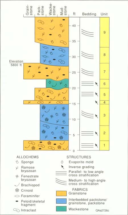
Tansill-equivalent, grain-dominated, gravity-flow deposits are characteristic of the middle and upper portion of the Capitan slope. Stop 11 includes the gravity-flow deposits exposed along the trail from just below the 5,800-ft marker to ~9 m (~30 ft) up the trail beyond the marker. Nine stratigraphic units are distinguished within the gravity-flow deposits at Stop 11 (figs. 22 and 23a, 23b).
|
| FIGURE 22. Measured section (perpendicular to dip) of the grain-dominated gravity-flow deposits at Stop 11. |
|
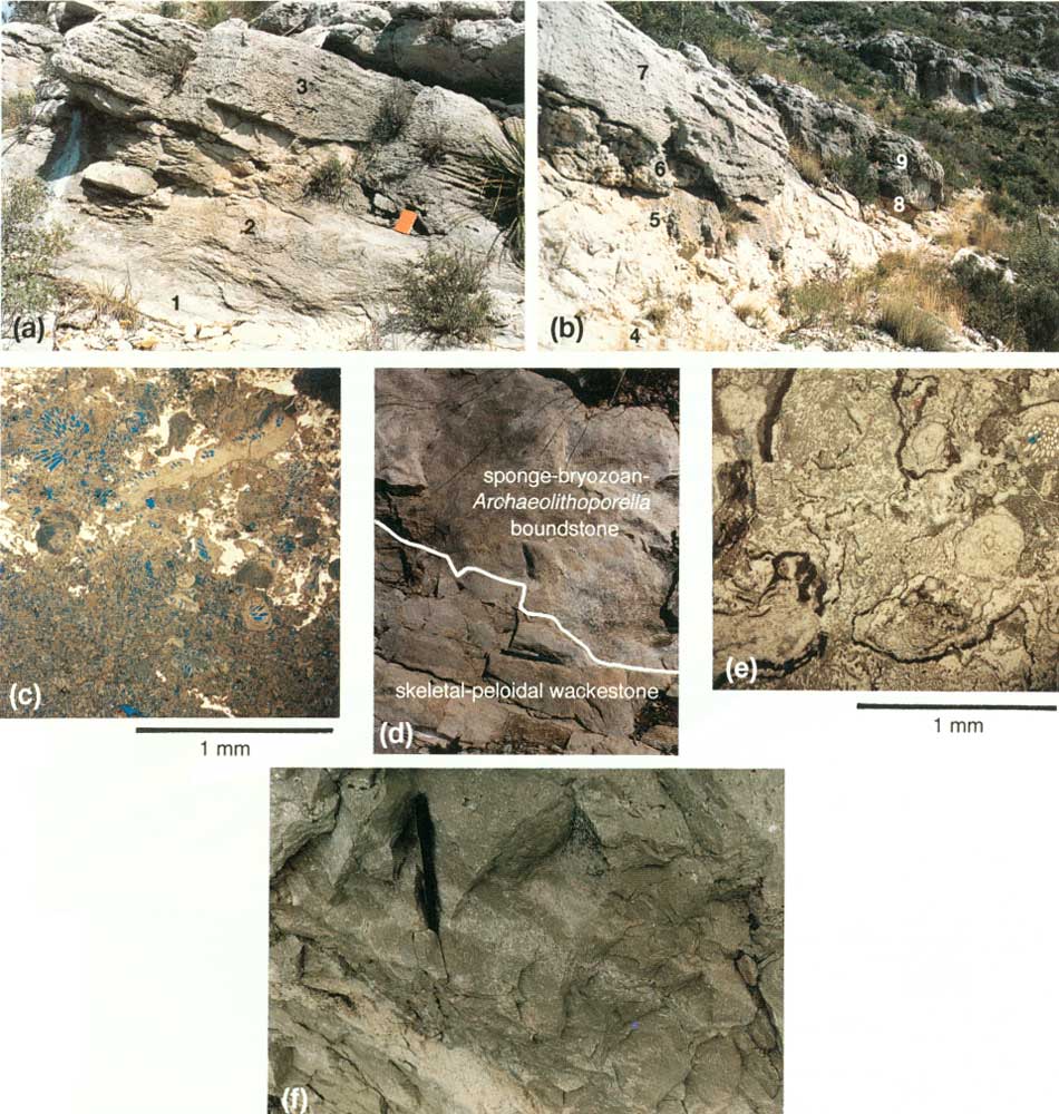
| FIGURE 23. Stop 11, trail photographs of the grain-dominated gravity-flow deposits; (a) units 1-3, (b) units 4-9, (c) thin-section photograph of fine-grained skeletal-peloidal grainstone at base to coarse-grained bryozoan-skeletal grainstone at top. Stop 12, trail photographs and thin-section photographs; (d) sponge-bryozoan-Archaeolithoporella boundstone over dark-gray, fine-grained skeletal-peloidal wackestone, (e) thin section of spong-bryozoan-Achaeolithoporella boundstone, (f) bryozoan wackestone with lens of packstone. (click on image for an enlargement in a new window) |
The slope beds exposed at Stop 11 dip at 25° to 30°. The beds are lithoclastic, skeletal-peloidal wackestone to grainstone. Contacts between the major units are irregular to scoured. The upper beds are cross stratified, and most beds show inverse grading and internal scour. Fossils include fragments of bryozoans, brachiopods, foraminifers, Tubiphytes, and sponges (fig. 23c). Plates and columnals of robust crinoids are characteristic of the skeletal grains in the older units 1-3. Intraclasts are common throughout and consist of light-colored shelf packstone and dark-colored slope wackestone and packstone.
The gravity-flow units at Stop 11 (fig. 23) are interpreted to represent deposits of predominantly high-density turbidity currents. Internal scour and inverse grading provide evidence of traction sedimentation and traction carpet sedimentation, respectively. Large-scale crossbedding in units 8 and 9 (fig. 23b) may represent small dune forms that were deposited from the bed load of very thick, high-density turbidity currents. Exposures at Stop 11 may record deposition from the proximal end of cohesive debris flows that were deposited on the less steeply dipping lower slope.
The stratigraphic position of the gravity-flow deposits at Stop 11 relative to other units can be determined by correlating these beds to basin and reef facies on the photomosaic (fig. 20). Gravity-flow deposits exposed at Stop 11 can be traced downslope to where they thin into the lower part of the Lamar. The slope beds have been traced updip to the steeply dipping beds that over lie the massive Yates-equivalent reef exposed at switchback D. These correlations indicate that the gravity-flow deposits at Stop 11 were derived from Tansill-equivalent reef beds and were deposited at the same time as the lower part of the Lamar.
The grain-dominated, gravity-flow deposits suggest that reef growth was active and abundant carbonate sediment was being transported into the basin while the Lamar interval was accumulating. The steeply dipping beds of the upper part of the slope exposed at switchback D (fig. 20) suggest that sediment was shed from a largely aggradational reef. Gravity-flow deposits on the slope may reflect periods when the slope became oversteepened and unstable from high rates of carbonate production on the reef. These observations on the slope beds are consistent with the conclusions of Babcock and Yurewicz (1989) and Garber and others (1989) that the crest of the shelf-margin buildup gradually shoaled during the depositional history of the Yates- and Tansill-equivalent reefs.
STOP 12. Slope Mud-Rich Carbonate
Stop 12 displays reef blocks and mud-rich, fine-grained deposits of the upper part of the slope that are poorly bedded relative to the very thick bedded, gravity-flow deposits examined at Stops 9-11. A block of reefal boundstone is well exposed just before the 5,900-ft marker (fig. 23d and 23e). Note that the 5,900-ft marker is located ~1.5 m (~5 ft) above the trail. The outcrop consists of boulders of massive, sponge-bryozoan-Archaeolithoporella boundstone and fine-grained, skeletal-peloidal wackestone to packstone (fig. 23d). Reef blocks exposed here have a higher density and diversity of frame-building sponges than the reef blocks examined in the younger debris-flow deposits at Stop 9. The amount of Archaeolithoporella and botryoidal fibrous cement is also proportionately reduced. Reef blocks at Stop 12 and on the upper part of the slope crop out as matrix-encased piles of boulders and as isolated blocks encased in mud-rich, upper-slope beds. This distribution suggests that the reef blocks accumulated as rock fall and may have locally formed talus cones.
The best exposures of the mud-rich upper part of the slope beds are located ~9 m (~30 ft) up the trail from the 5,900-ft marker and past a prominent gully at the point where the trail bends slightly to the left. The mud-rich carbonate is thin- to very thick-bedded, with dips between 15° and 20°. The bedding in outcrops exposed above the trail appears to be deformed or slumped. Massive, fine-grained peloidal wackestone and packstone dominate the section, but small lenses of grainstone and lithoclast wackestone and packstone are present (fig. 23f).
The mud-rich carbonate contains a diverse, deep neritic fauna of ramose and fenestrate bryozoans, sponges, brachiopods, and crinoids. Cephalopods are also abundant. Some of the well-preserved fossils appear to be indigenous, especially the articulated brachiopods and large fenestrate bryozoans. The poorly developed bedding suggests that the sponges and bryozoans were transported as individual grains to form debris cones, rather than as components of debris flows or turbidity currents. An alternative explanation for the origin of the massive, fossiliferous limestone on this portion of the slope is deposition from submarine slumping. The steep slopes, fine-grained sediment, and lack of binding or cementation favor this interpretation. Evidence of synsedimentary internal deformation is inconclusive.
Mud-rich, fossiliferous limestone exposed in the gully area at the up-trail end of Stop 12 coarsens downward into thin-bedded, coarse-grained, sponge-bryozoan lithoclastic grainstone. Lithoclastic grainstone is best examined farther up the trail, where the trail turns back to the right and exposes an outcrop less oblique to bedding. The grainstone is dolomitized and much lighter in color than the dark-brown massive limestone. The base of the grainstone is sharp, irregular, and probably erosional. The skeletal and lithoclast grainstone beds are interpreted as high-density turbidity current deposits. Similar thin, dolomitized gravity-flow deposits punctuate the massive mud-rich limestones throughout the slope section.
STOP 13. Slope Mixed Siliciclastics and
Carbonates
Stop 13 includes two siliciclastic sandstone beds and intervening carbonates that were deposited on the upper part of the slope (fig. 24). This stop begins where the trail steepens at the first extensively weathered, yellow siliciclastic interval (younger). The contact of the siliciclastics with the overlying carbonate examined at Stop 12 crops out on the floor of the trail (fig. 25a). The intervening carbonate beds are present farther up the trail and are well exposed at the light-tan grainstone outcrop just beyond the trees that cover the trail. The second siliciclastic interval (older) crops out at the 6,000-ft marker.
|
| FIGURE 24. Diagramatic sketch of the slope beds of Stops 12-14 showing carbonate textures and fabrics encountered along this part of the trail and location of stops relative to elevation markers and geographic features. The section was measured along the trail perpendicular to slope dip; areas marked as cover are not to scale. (click on image for an enlargement in a new window) |
The first sandstone bed is a recessively weathered, ~6-m-thick (~20-ft) bed that is concordant with other slope beds. All units within the siliciclastic interval have dips between 25° and 32°, and there is no apparent angular discordance between any of the units. The siliciclastic beds are discontinuous and cannot be traced in outcrop into the basin or onto the shelf. Sedimentary structures within the sandstone are not apparent in outcrop. The second siliciclastic unit was deposited around boulders of sponge-Archaeolithoporella boundstone and has limited exposure along the trail.
|
| FIGURE 25. Stop 13, trail and thin-section photographs: (a) irregular contact between sandstone and overlying lithoclastic grainstone, (b) sandstone filling in apparent growth-framework voids in Archaeolithoporella-encrusted sponge colony, (c) thin-section photomicrograph of very fine- to fine-grained, well-rounded sandstone with a dolomite matrix and kaolinite-filled molds of dissolved feldspar grains, (d) dolomitized thin-bedded, fine- to coarse-grained skeletal packstone and grainstone, (e) thin-section photomicrograph of dolomitized skeletal grainstone with skeletal grains cemented by isopachous fibrous cement, a thin rind of dolomite, and late poikilolitic calcite, (f) skeletal-lithoclast rudstone with clasts of fine-grained skeletal wackestone and the youngest occurrence on the slope of the fusulinid Polydiexodina, cemented by late-stage calcite. (click on image for an enlargement in a new window) |
The siliciclastic beds are composed of very fine grained to fine-grained, well-rounded quartz grains in a dolomite matrix (fig. 25b). Rounded molds containing authigenic kaolinite are interpreted to be dissolved feldspars (fig. 25c). Calcite pseudomorphs after gypsum crystals are also randomly distributed throughout the sandstone. The sandstone contains a reef fauna of Tubiphytes, Archaeolithoporella, sponges, and bryozoans, some apparently in growth position. Where the skeletal grains are preserved, they are dolomitized and have a white, chalky appearance. Molds of dissolved fossils are filled with calcite.
The dolostones between the siliciclastic beds are thin-bedded, fine- and coarse-grained, skeletal packstone and grainstone that were probably deposited on the steep upper part of the slope by high-density turbidity currents and grainflows, respectively (fig. 25d and 25e). The skeletal grains include sponges, ramose bryozoans, crinoid plates and columnals, brachiopods, foraminifers, phylloid and dasycladacean algal fragments, and peloids. The skeletal grains have been micritized and cemented by a thin isopachous fibrous cement, a thin rind of dolomite rhombs, and late poikilotopic calcite. The late calcite is interpreted to have replaced earlier evaporites (Scholle and Melim, 1988). The light-tan dolostone grades laterally into undolomitized, dark-tan packstone and wackestone.
The sandstone and carbonate outcrops at Stop 13 illustrate selective dolomitization of permeable, siliciclastic and grain-rich carbonate beds on the slope. The primary stage of dolomitization in the slope is interpreted to have formed during early burial by seepage reflux of penecontemporaneous, back-reef lagoonal brines (Melim, 1991). Isotopic composition of the dolomites indicates that the brines were mesosaline; that is, concentrations are greater than seawater but less than gypsum saturation (Melim, 1991). The mesosaline brines initially descended via joints and fractures driven by the density contrast between brine and seawater. The mesosaline brines migrated from the joints along the most permeable pathways into slope deposits, commonly the grainstone and siliciclastic beds. Selective dolomitization of debris-flow deposits adjacent to siliciclastic beds in the lower portion of the slope (Stop 9) demonstrates the basinward extent of permeability-controlled, density-driven dolomitization. Gypsum molds preserved in the sandstone (Stop 13), high density-turbidity current deposits (Stop 11, unit 6), and debris-flow deposits (Stop 9, switchback B) suggest that the early mesosaline brines may have been followed by a later stage of more concentrated, hypersaline brines. Other examples of interpreted joint- and permeability-controlled dolomitization are visible in the beds that intersect the upper portion of the trail above Stop 13, grainstones exposed at switchback D, and shelf beds exposed at Stop 23.
The slope sandstone and carbonate sequence at Stop 13 overlies carbonate beds that contain the youngest occurrence of Polydiexodina on the trail (fig. 25f). Polydiexodina ranges upward to near the top of the Yates B interval on the shelf and to the McCombs Limestone Member of the Bell Canyon Formation in the basin (Newell and others, 1953). The sandstones at Stop 13 are stratigraphically higher than the Polydiexodina, so they are interpreted to correlate to the Yates C member on the shelf and the sandstone that rests between the McCombs and Lamar Limestone Members of the Bell Canyon Formation in the basin. According to biostratigraphy and slope-to-basin correlations, the siliciclastic beds at Stop 13 mark the top of the Yates Formation on the slope. The shelf siliciclastic beds that correlate to slope siliciclastics are exposed at Stop 26.
Outcrops between the sandstones at Stop 13 and the 6,100-ft marker at Stop 14 are thin- to medium-bedded skeletal wackestones and packstones surrounding sponge-Archaeolithoporella boundstone reef blocks in beds that dip at 27° These slope beds with reef blocks are generally similar to those discussed at Stop 12.
STOP 14. Fusulinid-Rich, Shelf-Margin Talus
Stop 14 is located between the 6,100-ft marker and switchback C and includes the very distinctive, steeply dipping (27° to 66°) Polydiexodina beds that were deposited in the area of shelf-margin talus exposed at the 6,100-ft marker (figs. 20 and 26a and 26b).
|
| FIGURE 26. Stop 14, trail and thin-section photographs: (a) inversely graded skeletal-fusulinid packstone to grainstone with the long axes of the fusulinids aligned parallel to dip of 27° to 32°, (b) plan view of steeply dipping fusulinid grainstone, fusulinids are ~2 cm long (~0.8 inch), (c) thin-section photomicrograph of inversely graded peloidal-skeletal grainstone to fusulinid-algal grainstone, the dolomitized skeletal grains (fusulinids, platy algae) are coated with isopachous fibrous cement, a thin rind of dolomite, and coarse calcite, (d) thin-section photomicrograph of fusulinid grainstone showing the isopachous fibrous cement around fusulinid grains and equant calcite cement filling most of the remaining interparticle space. (click on image for an enlargement in a new window) |
The exposure of the youngest occurrence of Polydiexodina consists of poorly sorted, skeletal-lithoclastic rudstone. Skeletal grains include the pinnate bryozoan Acanthocladia and fenestrate bryozoans, in addition to Polydiexodina. Lithoclasts are fine-grained skeletal wackestone and are subangular. These clasts were apparently derived from underlying slope wackestones and packstones. Examination of lithoclastic beds beneath the reef blocks shows apparent in situ brecciation of the slope sediments. The lithoclasts and rudstone texture may have developed during dislocation and movement of reef-derived boulders as submarine slides on the slope.
The trail cuts through ~9 to 12 m (~30 to 40 ft) (measured perpendicular to bedding) of skeletal-fusulinid packstone and grainstone (fig. 26b and 26c) at Stop 14. Dips of the fusulinid beds are highly variable and range from 27° to 66°. This wide range of dips is a result of deposition between and over allochthonous blocks of reef facies. Fusulinids in the beds with steepest dip have variable orientations and occur in lenses. Where fusulinid beds have dips closer to the observed depositional slope dips of 27° to 32° the beds are inversely graded, with long axes of the fusulinids parallel to dip. These beds are inversely graded from peloidal-skeletal packstone to very coarse-grained, fusulinid-algal grainstone. The skeletal component includes segments of the dasycladacean alga Mizzia, fusulinids, crinoid plates and columnals, platy algae, and bryozoans. The inversely graded beds are best exposed directly beneath the 6,100-ft marker.
The proximity of Stop 14 to the reef (fig. 20) places it in the zone of shelf-margin talus. This is an area that on modern reefs is typically characterized by an apron of reef blocks encased in skeletons of perireefal sediments, reef-building organisms, carbonate sand grains, and lime mud (Land and Moore, 1977; James and Ginsburg, 1979). Reef blocks observed at Stop 14 were probably deposited by rock fall off the Yates-equivalent reef. The steep dips and inverse grading of the surrounding fusulinid grainstones suggest that the fusulinids were deposited as grain flows. The concentrated occurrence and channelized appearance of the fusulinids and associated skeletal grains at this location may indicate that they have been funneled through a pass or channel in the reef.
Fusulinids are benthic foraminifers that lived on shallow-water shelves and shelf margins in water depths of 14 to 18 m (45 to 60 ft) (Ross, 1983). The abundance, robust size, and excellent preservation of fusulinids on the slope suggest that they thrived on the shelf and were transported downslope. The accumulation here of numerous fusulinids of the same size, shape, and specific gravity was probably controlled by local hydrodynamic conditions.
Summary
The perspective of the slope beds from the 6,200-ft marker near the top-of-slope portion of the trail offers an excellent opportunity to summarize the lithologies, slope depositional processes, and stratigraphic relationships of Stops 9-14.
The first four slope stops (Stops 9-12) are Tansill-equivalent (1) lithoclast megabreccia interpreted to be lower slope cohesive debris-flow deposits, (2) burrowed wackestone toe-of-slope deposits equivalent to the Lamar Limestone Member, (3) lithoclastic-skeletal wackestone-grainstone interpreted to be high-density turbidity-current deposits, and (4) slumped reef blocks and fine-grained peloidal wackestone-packstone of the upper part of the slope. These carbonate facies represent periods of active growth at the shelf margin and transportation of carbonate into the basin. Several intervals of high-volume sediment transport are identified in the Tansill-equivalent, slope beds (fig. 20). Grain-dominated, high-density turbidity current deposits are characteristic of the upper and middle portions of the slope, where the slope dips are 20° to 35° and mud- and boulder-dominated cohesive debris-flow deposits are typical of the 10° to 20° dip of the lower part of the lower slope.
The last two stops are in Yates-equivalent slope beds. Dolomitic, fine-grained siliciclastics, sponge boundstone, and dolomitized grainstones are exposed at Stop 13 and are equivalent to the youngest Yates "C" member of Newell and others (1953) (fig. 4) or the Yates-Tansill sequence of figure 35 and are interpreted to represent a major sea-level lowstand. Lowstand beds can be correlated biostratigraphically with equivalent shelf and basin strata. Steeply dipping, skeletal-fusulinid packstone-grainstone and shelf-margin talus are exposed at Stop 14. The thick accumulation of fusulinids and variable dips may indicate the presence of a pass or channel in the Yates-equivalent reef.
| <<< Previous | <<< Contents >>> | Next >>> |
state/tx/1993-26/sec2.htm
Last Updated: 2-Apr-2007