
|
Texas Bureau of Economic Geology
Guide to the Permian Reef Geology Trail, McKittrick Canyon, Guadalupe Mountains National Park, Texas |
CONTENTS
Introduction
Don G. Bebout, Charles Kerans, and Paul M. Harris
Geologic Setting
The Trail
Toe of Slope
Alton Brown and Robert G. Loucks
Stop 1. Quaternary-Age Alluvial Conglomerate
Stop 2. Distal Toe-of-Slope Wackestone
Stop 3. Distal Toe-of-Slope Debris-Flow Deposits
Stop 4. Vertical and Lateral Changes in Toe-of-Slope Sedimentation
Stop 5. Stratigraphic Relations on the South Side of the Canyon
Stop 6. Turbidites and Debris-Flow Deposits
Stop 7. Transition from Toe of Slope to Slope
Stop 8. Top of Lamar Limestone Member
Summary
Slope
Denise Mruk and Don G. Bebout
Stop 9. Mud-Dominated Gravity-Flow Deposits
Stop 10. Slope/Toe-of-Slope Burrowed Wackestone
Stop 11. Grain-Dominated Gravity-Flow Deposits
Stop 12. Slope Mud-Rich Carbonate
Stop 13. Slope Mixed Siliciclastics and Carbonates
Stop 14. Fusulinid-Rich, Shelf-Margin Talus
Summary
Reef
Brenda L. Kirkland, Susan A. Longacre, and Emily L. Stoudt
Stop 15. Interbedded Basal Reef and Slope Deposits
Stop 16. Well-Exposed Sponge Archaeolithoporella Boundstone
Stop 17. Tubiphytes/Acanthocladia Boundstone
Stop 18. Fusulinids within the Reef
Stop 19. Pockets or Neptunian Dikes within the Reef
Stop 20. Typical Reef Outcrops and Cave Fill
Stop 21. Reef Diagenesis
Stop 22. Upper Reef—Collenella, Fusulinids, and Dolomite
Summary
Outer Shelf and Shelf Crest
Charles Kerans and Paul M. Harris
Stop 23. Reef/Outer-Shelf Transition Zone
Stop 24. Exposure Surface within Yates Outer Shelf
Stop 25. Outer-Shelf Packstone-Grainstone Cycles
Stop 26. Mixed Siliciclastic/Carbonate Outer-Shelf Cycles
Stop 27. Shelf-Crest Cycles
Stop 28. Outer-Shelf Dolopackstones
Summary
Geology Loop Trail
Alton Brown and Robert G. Loucks
Stop 29. Margin of Slope Gully
Stop 30. Slope Gully Fill
|
| (click on image for an enlargement in a new window) |
FIGURES
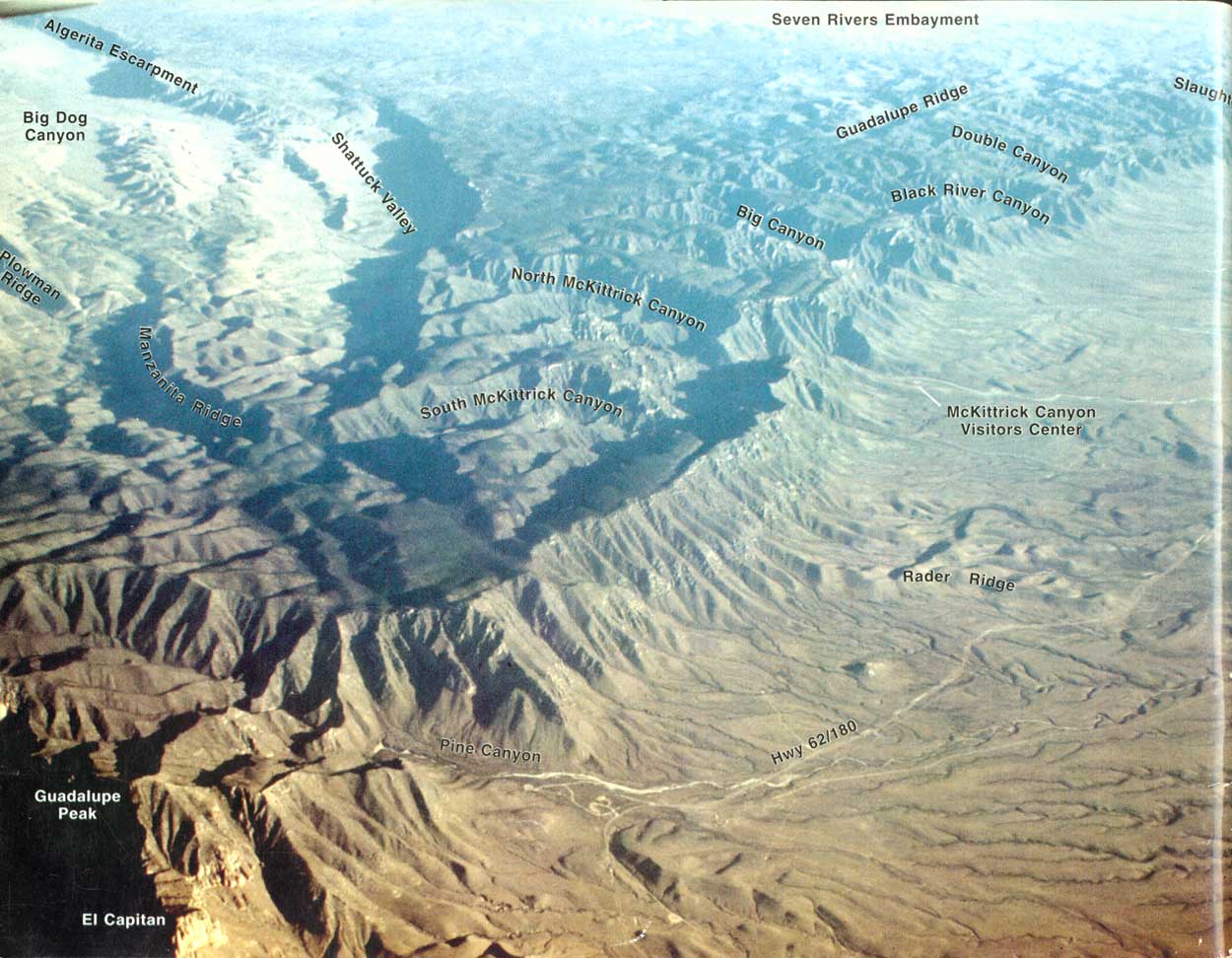
1. Map of the Capitan reef front, Guadalupe Mountains, and location of McKittrick Canyon, other major canyons along the escarpment, Guadalupe Peak, and El Capitan
2. Topographic map of the mouth of McKittrick Canyon showing the location of the Permian Reef Geology Trail and trail stops
3. Map of the Permian Basin showing the location of the upper Guadalupian reef trend, oil and gas fields producing from equivalent strata in the subsurface, and mountains with exposures of upper Guadalupian formations
4. Cross section showing shelf-to-basin correlations of the Capitan Formation and equivalents
5. Hypothetical paleobathymetric profiles across the Capitan shelf margin
6. Photomosaic of the north wall of McKittrick Canyon showing formation boundaries, interpreted depositional facies profiles, and correlation horizons within the Seven Rivers and Yates Formations
7. Diagrammatic sketch of the north wall of McKittrick Canyon showing the stratigraphy, depositional environments, present-day erosional profile, and general location of the Permian Reef Geology Trail
8. Dip-oriented, structural cross section of the toe-of-slope Lamar Limestone Member exposed on the north wall at the mouth of McKittrick Canyon
9. Stop 2, trail and thin-section photographs
10. Stop 3, trail and thin-section photographs
11. Stop 3, measured section with interpreted depositional processes
12. Stop 4, trail and thin-section photographs
13. Regional variations along a reef-to-basin cross section of depositional dip and lithology and thickness of the Lamar Limestone Member
14. Stratigraphic section of the interval near the peloidal packstone along the north wall of McKittrick Canyon
15. Interpretation of lithology and bedding relationships on the cliff of Lamar Limestone Member on the south side of McKittrick Canyon (Stop 5)
16. Photograph of the south wall of McKittrick Canyon across from Stop 5 showing the basinal carbonate members merging with the Capitan Limestone
17. Photograph of ungraded skeletal packstone along the trail at Stop 6
18. Stop 7, trail and thin-section photographs
19. Measured section at Stop 7 with depositional interpretations
20. Dip-oriented oblique aerial photograph and an interpretive tracing of the slope and toe-of-slope portion of the Permian Reef Geology Trail
21. Stop 9, trail and thin-section photographs
22. Measured section (perpendicular to dip) of grain-dominated gravity-flow deposits, Stop 11
23. Stop 11, trail photographs of the grain-dominated gravity-flow deposits
24. Diagrammatic sketch of the slope beds of Stops 12-14 showing carbonate textures and fabrics encountered along this part of the trail and location of stops relative to elevation markers and geographic features
25. Stop 13, trail and thin-section photographs
26. Stop 14, trail and thin-section photographs
27. Stop 15, basal reef
28. Stop 16, sponges of the Capitan reef
29. Stop 17, Tubiphytes and Acanthocladia in reef
30. Stop 18, fusulinids in reef, and Stop 19, pockets or neptunian dikes
31. Stop 20, Permian internal sediment and cave fill in reef
32. Stop 21, reef cement
33. Stop 21, reef cement, and Stop 22, Collenella zone
34. Oblique aerial photograph of upper portion of Permian Reef Geology Trail showing reef Stops 17-22 and shelf Stops 23-28, elevation markers, major switchbacks, and key stratigraphic relations
35. Measured sections for the outer shelf and shelf crest portion of the trail showing stratigraphic nomenclature, sequences and cycles, and the position of Stops 23-28
36. Outcrop and thin-section photographs of Stop 23 reef/outer shelf transition
37. Schematic diagram showing facies relations documenting exposure of outer shelf associated with top Yates 4 sequence boundary
38. Outcrop and thin-section photographs of Stop 24 exposure surface
39. Approximate time line connecting youngest known occurrence of the fusulinid Polydiexodina along the trail
40. Panoramic photomosaic and interpretive sketch of the portion of the trail discussed in Stop 25 looking down the trail into the basin
41. Cross section of outer shelf strata in Yates 4, Yates—Tansill 1 sequences from the area of Stop 25
42. Outcrop and thin-section photographs of Stop 25 outer-shelf cycle
43. Schematic facies patterns seen in outer shelf fall-in beds of Stop 25
44. Outcrop and thin-section photographs of Stops 26-28 siliciclastic-carbonate and carbonate cycles
45. Trail photograph of margin of slope gully at Stop 29
46. Schematic strike cross section between the lower Grotto (Stop 4) and Stop 30
| <<< Previous | <<< Contents >>> | Next >>> |
state/tx/1993-26/contents.htm
Last Updated: 2-Apr-2007