
|
Texas Bureau of Economic Geology
Guide to the Permian Reef Geology Trail, McKittrick Canyon, Guadalupe Mountains National Park, Texas |
OUTER SHELF AND SHELF CREST
Charles Kerans and Paul M. Harris
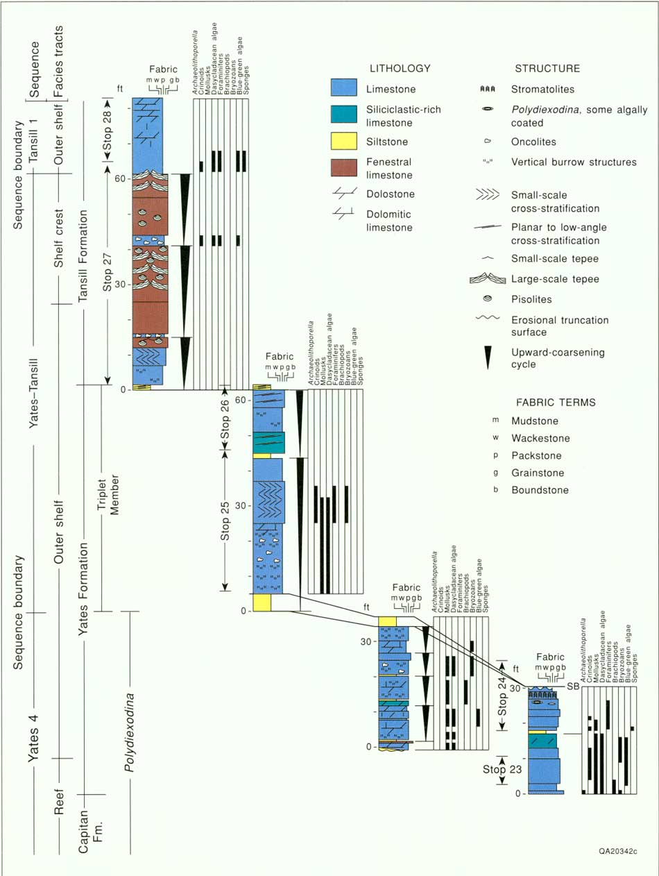
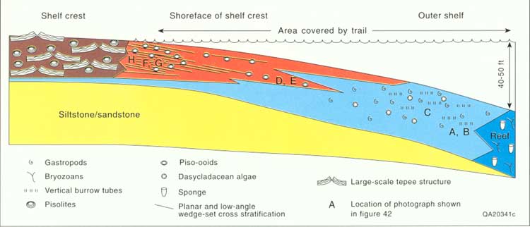
This segment of the Permian Reef Geology Trail includes progradational outer-shelf facies of the upper most Yates Formation and both shelf-crest and possibly outer-shelf facies of the basal Tansill Formation (fig. 7). The reef/outer-shelf transition occurs at Stop 23 (switchback G), and this portion of the trail extends to the ridge crest (Stop 28) just above 7,000 ft (fig. 34). The total stratigraphic interval exposed in this section of the trail is 60 m (200 ft), slightly less than the total topographic relief because of 1° to 2° structural dip to the northeast (Hayes and Koogle, 1958). The Yates Formation as exposed along the trail is 33 m (110 ft) thick (fig. 35). Farther up canyon, in an updip position where the uppermost portions of the Yates Formation are removed by post-uplift erosion, Newell and others (1953) measured a maximum thickness of 88 m (290 ft) for the Yates Formation. On the Northwest Shelf, Borer and Harris (1991) demonstrated from subsurface correlations that the Yates exceeds 122 m (400 ft) in thickness. Thinning of Yates shelf strata toward the basin occurs as Yates-equivalent Capitan reef facies climb stratigraphically. Thus, the Permian Reef Geology Trail, which cuts the Yates in a position close to its terminal shelf-margin position, records only the upper quarter to third of the Yates section (figs. 7 and 35). Tansill strata compose the uppermost 26 m (85 ft) of stratigraphic section along the trail. In more complete sections to the north along depositional strike, Tansill Formation thickness reaches 122 m (400 ft) (Hayes, 1964).
|
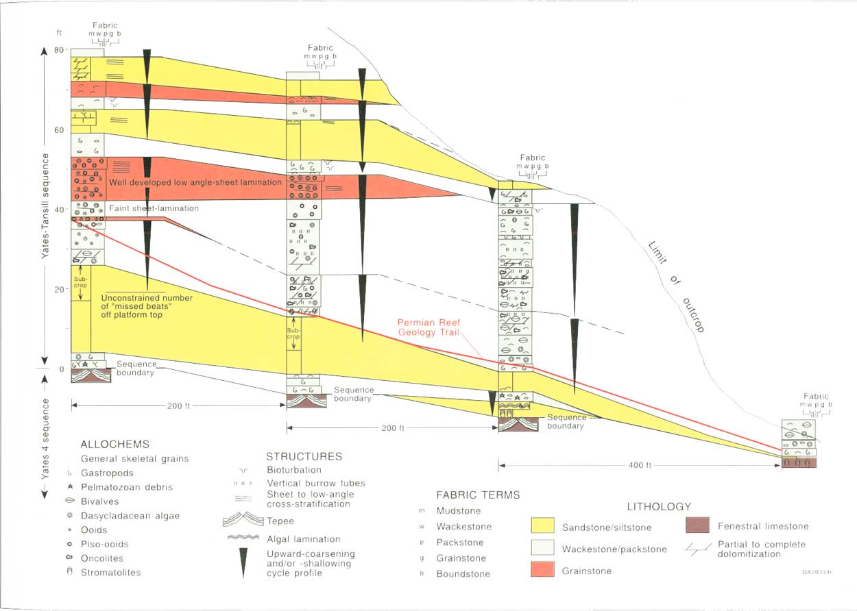
| FIGURE 35. Measured sections for the outer shelf and shelf-crest portion of the trail showing stratigraphic nomenclature, sequences and cycles, and the position of Stops 23-28. (click on image for an enlargement in a new window) |
Key observations concerning this portion of the trail are (1) the range of depositional facies characteristic of the outer-shelf and shelf-crest facies tracts of the Yates and Tansill Formations (cf. Neese and Schwartz, 1977; Esteban and Pray, 1983; Hurley, 1989; Neese, 1989; Borer and Harris, 1991), (2) the primary depositional dip (fall-in bed geometry) of the Yates shelf profile from the shelf crest downward to the shelf-edge reef, (3) the vertical arrangement or stacking patterns of these facies in small-scale (3 to 9 m [10 to 30 ft]), upward-coarsening cycles, (4) a key exposure surface that may represent a sequence boundary within the Yates outer shelf, and (5) the progressive upward increase in dolomitization of shelf strata following the overall progradation of evaporitic inner-shelf facies tracts over outer-shelf, open-marine deposits.
Six stops are described in this portion of the trail (figs. 34 and 35). The first four stops are in the Yates Formation: (1) the reef/outer shelf transition (Stop 23), (2) an exposure surface within the outer shelf (Stop 24), (3) outer-shelf upward-coarsening cycles (Stop 25), and (4) mixed siliciclastic/carbonate outer-shelf cycles (Stop 26). The remaining two stops are in the Tansill Formation: (5) shelf-crest cycles (Stop 27) and (6) outer-shelf dolopackstones (Stop 28). As in other portions of the trail, one must be aware that the trail cuts vertically through the section as well as laterally across depositional strike and dip. Most of the across-dip facies changes occur between Stops 24 and 26. Stop 25 contains lateral facies changes within outer-shelf cycles as they are traversed by the trail through several hundred feet of depositional dip in a seaward to landward direction.
STOP 23. Reef/Outer-Shelf Transition Zone
At Stop 23 the trail turns from a northeast to a northwest heading as it passes from the reef into the shelf at switchback G (figs. 34 and 35). This position represents the downdip termination of inclined outer-shelf or fall-in beds as they pass into the massive reef facies. The panoramic view from the trail to the northeast displays well the geometric relationship among the nearly flatlying, uppermost shelf-crest strata, the more steeply basinward-dipping, crudely stratified outer-shelf beds, and the massive reef. This fall-in bed geometry is best developed in older Seven Rivers strata (Hurley, 1989) but is also apparent throughout the Yates Formation and to a lesser degree in the Tansill Formation. Hurley (1989) used geopetal fabrics to show an original depositional dip of 8° for Seven Rivers fall-in beds and an additional postdepositional overprint of 2° to 3° due to tectonic or compactional tilting, for a total of 10° to 11°. As the Capitan reef generally shallowed through time (Babcock and Yurewicz, 1989) the dip of the fall-in beds became progressively less. However, stratification on the north wall of McKittrick Canyon (fig. 6) shows apparent repeated shallowing of the reef and progressive flattening of fall-in bed dips that are related to more short-term variations of the shelf margin.
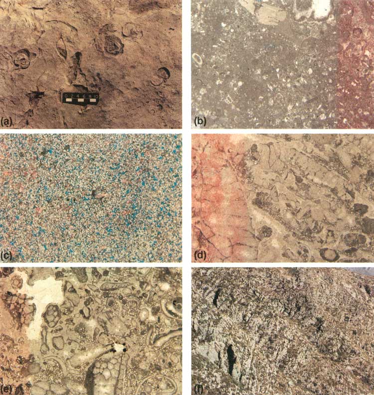
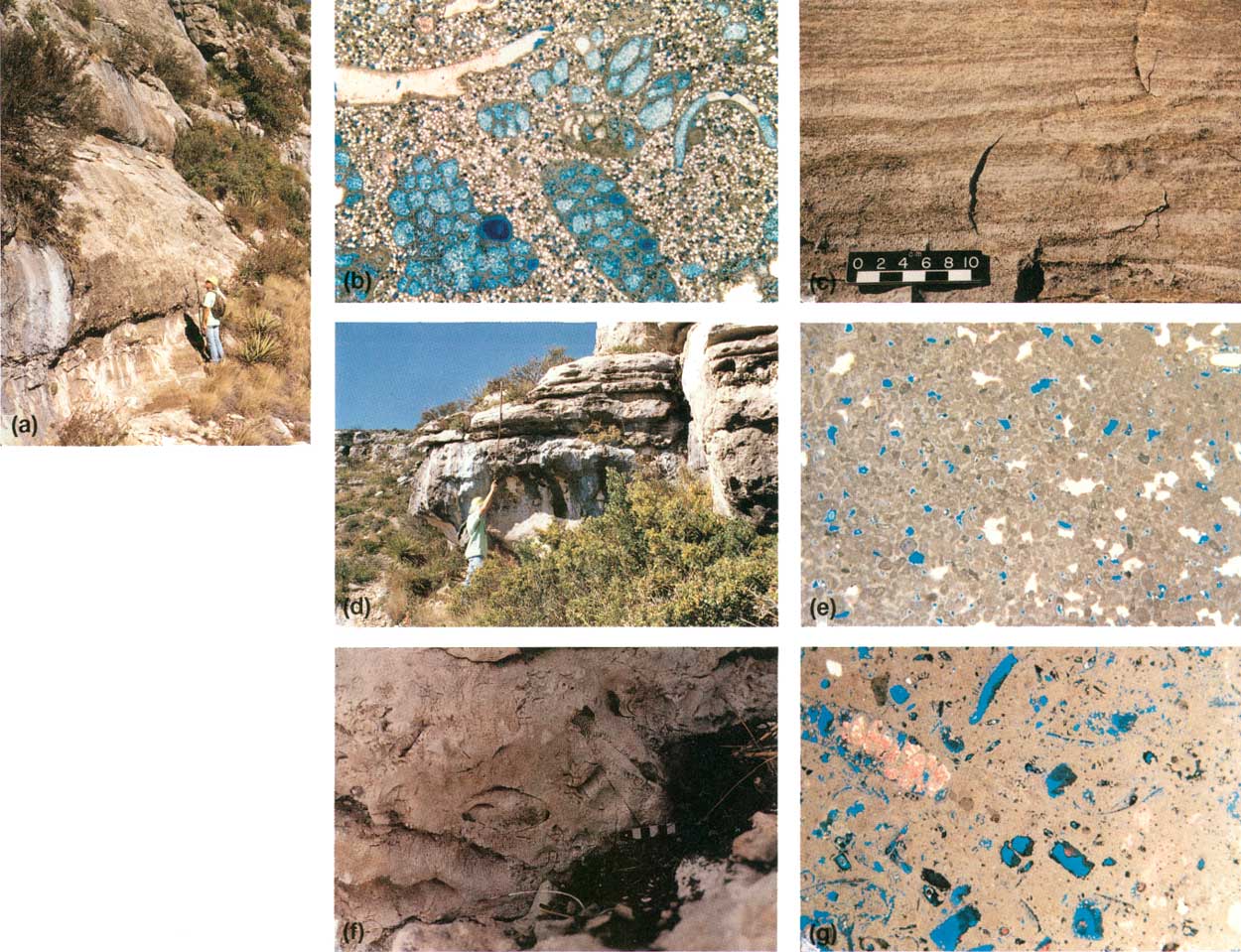
For ~15 m (~50 ft) shelfward along the trail from switchback G, outcrops of limestones with minor dolostones display a mix of depositional fabrics including boundstone, wackestone, packstone, and grainstone. Bedding is poorly developed and neither crossbedding nor bioturbation has been observed. One area of boundstone may represent a low-relief mound. A high percentage of grains displays micritic (cyanobacterial?) coatings. The skeletal component includes mollusks (both bivalves and large bellerophon gastropods) (fig. 36a), green algae (minor Mizzia), sponges, crinoids, and rare foraminifers, including the fusulinid Reichelina (fig. 36b). One bedding surface displaying largely intact specimens of crinoids and clusters of sponge spicules represents slightly reworked filter-feeding communities that attest to moderate wave energy or preservation by rapid burial or both.
|
| FIGURE 36. Outcrop and thin-section photographs of Stop 23 reef/outer shelf transition: (a) bedding surface showing large gastropods in skeletal packstone (scale bar in cm), (b) photomicrograph of lithoclast-skeletal-peloid packstone with pelmatozoan fragments, gastropods, various foraminifers (including Reichelina), and minor Mizzia, (c) photomicrograph of very well sorted, fine- to medium-grained, dolomitic siltstone with abundant secondary porosity resulting from feldspar dissolution and late-stage calcite cement, (d) photomicrograph of bryozoan grain-dominated packstone with quartz silt, grains rimmed by early-generation isopachous-fibrous calcite cement, and interparticle porosity filled with later clear blocky spar; (e) photomicrograph of skeletal packstone with abundant quartz silt; skeletal grains include mollusks, bryozoans, gastropods, and minor Mizzia. (early generation of cloudy isopachous-fibrous calcite shows possible corrosion prior to porosity occlusion by calcite spar); and (f) view to NE showing intense strike-parallel jointing in reef and slope portions of Yates-equivalent Capitan. Less well-developed shelf-perpendicular jointing is seen in figure 34. (click on image for an enlargement in a new window) |
A recessively weathered zone above iron-stained packstones 3 m (10 ft) above the base of the outer-shelf strata marks the position of a laterally discontinuous 0.2-m-thick (0.5 ft) siliciclastic siltstone bed. Siltstone beds typically mark high-frequency (5th order?) cycle boundaries, and sections containing several stacked cycles rich in siltstone can be used to subdivide the Yates Formation into mappable units (Candelaria, 1989; Borer and Harris, 1991). This siltstone is very well sorted, fine- to medium-grained, and dolomitic (fig. 36c), similar to siliciclastic-rich shelf facies from elsewhere in the Permian Basin (Candelaria, 1989; Borer and Harris, 1991). Siltstone porosity is largely restricted to secondary pores after dissolved feldspars. Photomicrographs from 1.5 m and 1 m (5 and 3 ft) below the silt bed (fig. 36d and 36e) illustrate the gradual introduction through time of siliciclastics onto the distal outer shelf before deposition of the siltstone bed proper. This relationship suggests that some siliciclastic detritus was transported across the outer shelf while it was still submerged or was mixed with underlying sediments by burrowing during the ensuing transgression. Several mechanisms have been proposed for siliciclastics bypassing the shelf, including eolian or desert fluvial transport (Mazzullo and others, 1986; Fischer and Sarnthein, 1988), offshore marine currents on a submerged shelf (Candelaria, 1989), bypassing during sea-level lowstands with trapping of sediments during reflooding (Borer and Harris, 1991), or by shelf-lagoon-derived saline density currents (Harms, 1974).
Diagenetic fabrics in the reef/outer shelf transition include an early generation of cloudy isopachous-fibrous calcite (probably relict Mg calcite, fig. 36d and 36e) and later clear, equant spar cements. Farther shelfward from the reef margin, the percent of early fibrous cement decreases markedly. Some iron sulfide and iron oxide appear as later phases, probably derived from leaching of iron-bearing siliciclastics from the siltstone.
Vertically oriented, tabular breccia bodies 10 to 40 cm (4 to 16 inches) wide occur in joints at switchback G. These brecciated joints, described at Stop 22, are selectively dolomitized and weather recessively, defining a distinctive reef parallel joint set (fig. 36f).
STOP 24. Exposure Surface within Yates Outer
Shelf
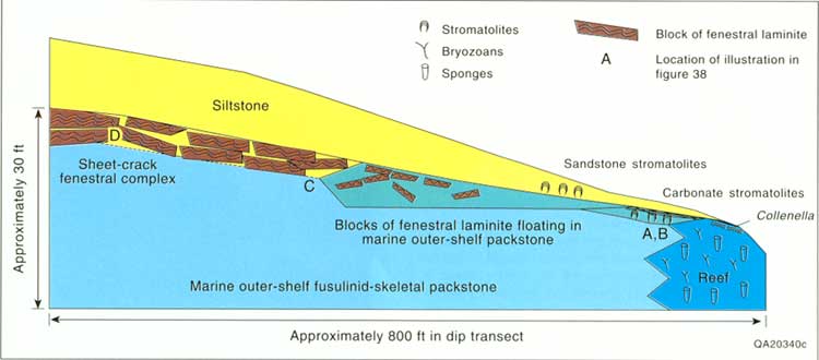
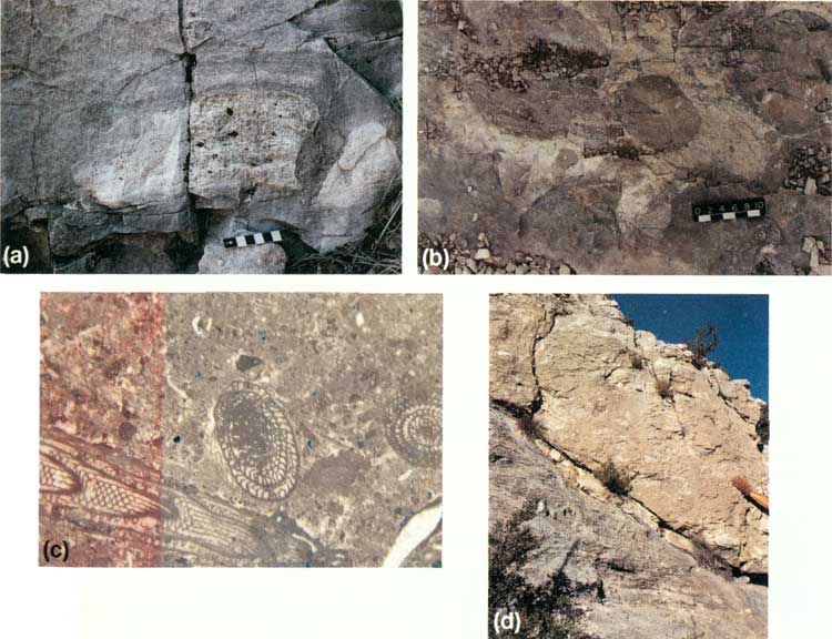
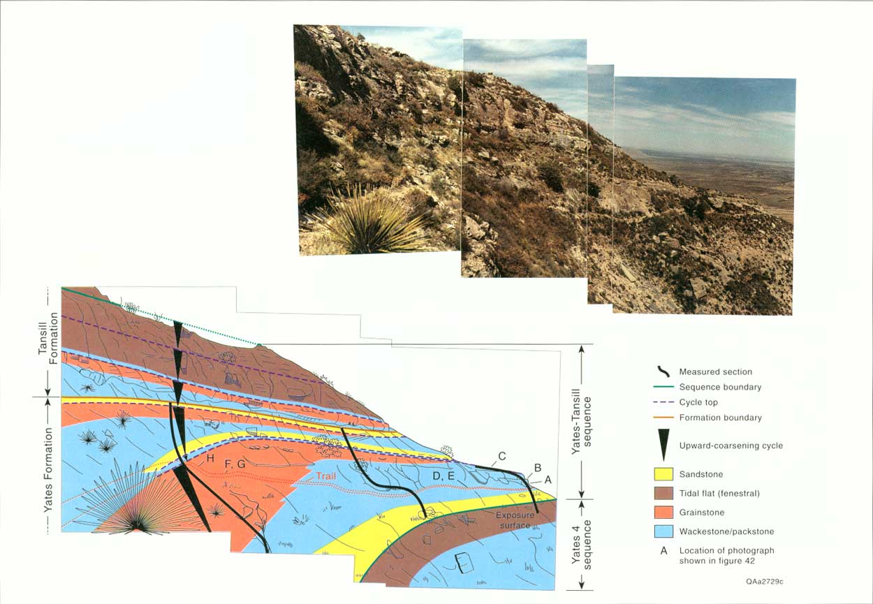
Immediately above, and in part superimposed upon, the reef/outer-shelf transition facies is a distinctive fenestral laminite/breccia unit that displays evidence of subaerial exposure and significant facies offset (fig. 37). The first evidence of this exposure event seen on the trail is at Stop 24, halfway between switchbacks G and H (figs. 34 and 35), ~6 m (~20 ft) before reaching the three large ponderosa pine trees that cover the trail. Fenestrally laminated columnar stromatolites and laminar fenestral cyanobacterial mats rest directly on packstones with a diverse outer-shelf fauna, suggesting that water depth shallowed abruptly (facies offset) (figs. 37, 38a, and 38b). The stromatolites are composed of light-gray micrite and are surrounded by gray to tan skeletal packstone. They display a slightly upward-widening profile in cross-sectional view in low outcrops along the south side of the trail (fig. 38a). Plan views display an interlocking network of cyanobacterial mats with intercolumnar sediment defining circular shapes (fig. 38b).
|
| FIGURE 37. Schematic diagram showing facies relations documenting exposure of outer shelf associated with top Yates 4 sequence boundary. Features included from seaward to landward across 244 m (800 ft) of depositional dip transect are carbonate stromatolites, fenestral laminites and breccias, and 0.6- to 6-m-thick (2-to 20-ft) sheet-crack/fenestral complexes. Dramatic basinward thinning of overlying siltstone is also shown (see also fig. 41), with marine-marginal facies displaying sandstone stromatolites (click on image for an enlargement in a new window) |
|
| FIGURE 38. Outcrop and thin-section photographs of Stop 24 exposure surface (general location of figures shown in fig. 37): (a) outcrop of small columnar stromatolites with fenestral porosity (scale in cm), (b) plan view of stromatolites along floor of trail. Note that light-gray material is stromatolite and darker skeletal-peloid sediment defines unusually cylindrical intercolumnar areas (scale in cm), (c) Photomicrograph of skeletal wackestone with the large benthic fusulinid Polydiexodina; blocky spar fills intraskeletal and minor interparticle porosity, (d) outcrop photograph showing thick sheet-crack breccia related to exposure surface with Polydiexodina wackestone of figure 38c directly below the breccia (hand for scale). (click on image for an enlargement in a new window) |
From this stromatolite outcrop shelfward along the trail to switchback H, a variety of features including breccia and fenestral structures are superimposed on typical outer-shelf Polydiexodina wackestones (figs. 37 and 38c). Just above switchback H ~3 m (~10 ft) beyond the 6,800-ft elevation marker the trail crosses the exposure surface again in a more shelfward position where sheet cracks and incipient tepee structures are capped by a recessive but persistent siltstone unit 0.3 m (1 ft) thick that is locally stromatolitic. Laterally along this surface sheet-crack breccia complexes up to 7.6 m (25 ft) thick are developed (fig. 38d) with peloidal internal sediment and paleoaragonite botryoids filling sheet cracks.
The recessively weathered siltstone resting atop the massive sheet-crack/breccia complex of the exposure surface creates a distinctive ledge (fig. 34) that can be traced from McKittrick Canyon northward along strike at least 4 km (2.5 mi) northeast to the next major dip-oriented reef exposure at Big Canyon (fig. 1) and is also traceable updip for several hundred feet (figs. 6, 36c, and 37). The combination of fenestral fabrics, shallow-water columnar stromatolitic growth forms, and thick sheet-crack breccia complexes with peloidal internal sediments suggests that this portion of the outer shelf, down to a point almost level with the reef, underwent prolonged subaerial exposure. The abrupt transition from open-marine to subaerial setting (facies offset), rather than the typical upward-shallowing facies progradation, supports interpretation of a major shallowing event and probable sequence boundary.
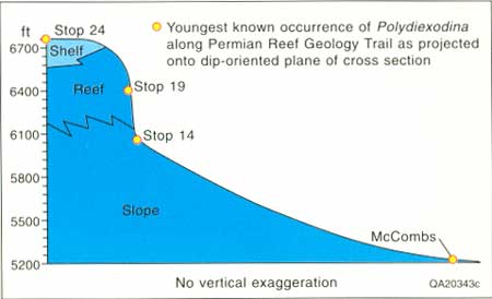
The top of the exposure surface along the trail is also equivalent to the top of the Yates "B" member of Newell and others (1953) as defined by physical correlation with their McKittrick Canyon sections and by the presence of the fusulinid Polydiexodina up to, but not above, this surface (fig. 35). The unit immediately below this exposure surface is the Yates 4 sequence. Polydiexodina also occurs in the slope no higher than the McCombs Limestone Member of the Bell Canyon Formation. If this correlation (Tyrrell, 1969) is valid, then it is possible to construct a time line from Stop 24 of the outer-shelf Yates Formation through Stop 19 within the reef to Stop 14 of the Capitan slope (fig. 39). In the toe of slope, the Bell Canyon sandstone interval between the McCombs and Lamar carbonate tongues may represent periods of shelf bypassing of siliciclastics during repeated shelf emergence (see fig. 4 and Stop 26 discussion). These Bell Canyon sandstones pinch out abruptly upslope into carbonate debris of the Capitan slope (fig. 20; King, 1948; Newell and others, 1953; Reeckmann and Sarg, 1986).
|
| FIGURE 39. Approximate time line connecting youngest known occurrence of the fusulinid Polydiexodina along the trail. This uppermost occurrence corresponds to the exposure surface illustrated in figures 37 and 38 and demonstrates a very steep depositional profile for the platform margin at this time. |
At switchback 1 the trail turns again to an oblique paleo-landward (west-northwest) orientation and climbs gradually topographically, parallel to the basinward-sloping outer-shelf fall-in beds (fig. 34).
STOP 25. Outer-Shelf Packstone-Grainstone
Cycles
Evidence of low-amplitude (1.5 to 9 m [5 to 30 ft]) high-frequency oscillations of relative sea level is apparent throughout the Permian shelf-top strata (Neese and Schwartz, 1977; Hurley, 1989; Wheeler, 1989; Borer and Harris, 1989, 1991; Kerans and Nance, 1991; Lindsay, 1991; Sonnenfeld, 1991), and recognition of cyclicity as the characteristic depositional pattern of the Yates and Tansill portions of the Permian will be emphasized in Stops 25 to 27.
Outcrops 3 to 9 m (10 to 30 ft) high on the north side of the trail for the next several hundred feet show a layered erosionally resistant to recessively weathered pattern characteristic of upward-coarsening carbonate cycles of the outer shelf (finer grained = recessive, coarser grained = resistant; figs. 34, 35, 40, and 41). These cycles, from above the exposure surface to where the thicker sandstone-capped cycles appear at Stop 26 just above the 6,900-ft marker, are equivalent to the lower portion of the Yates "C" of Newell and others (1953) or Yates-Tansill sequence of this chapter (figs. 4 and 35). In vertical succession, these cycles are composed of basal peloid-algal-skeletal packstones locally displaying large, subvertical peloid-filled burrows (fig. 42a and 42b) that are succeeded by mollusk-algal-peloid packstones and grainstones (fig. 42c). Skeletal components characteristic of the outer-shelf facies are mollusks, crinoids, green algae, the scaphopod Plagioglypra, and smaller benthic foraminifers.
|
| FIGURE 40. Panoramic photomosaic and interpretive sketch of the portion of the trail discussed in Stop 25 looking down the trail into the basin. The fall-in bed cycle that the trail traverses contains sandstone in its base, peloid-skeletal packstone in middle and upper portions in the more basinward exposures, and packstone grading upward into pisolitic-skeletal grainstone in updip portions of Stop 25 along the trail. Other cycles, sequence boundaries, and the location of measured sections from figure 41 are also shown. (click on image for an enlargement in a new window) |
|
| FIGURE 41. Cross section of outer shelf strata in Yates 4 and Yates-Tansill sequences from the area of Stop 25 (see fig. 40 for section location). (click on image for an enlargement in a new window) |
|
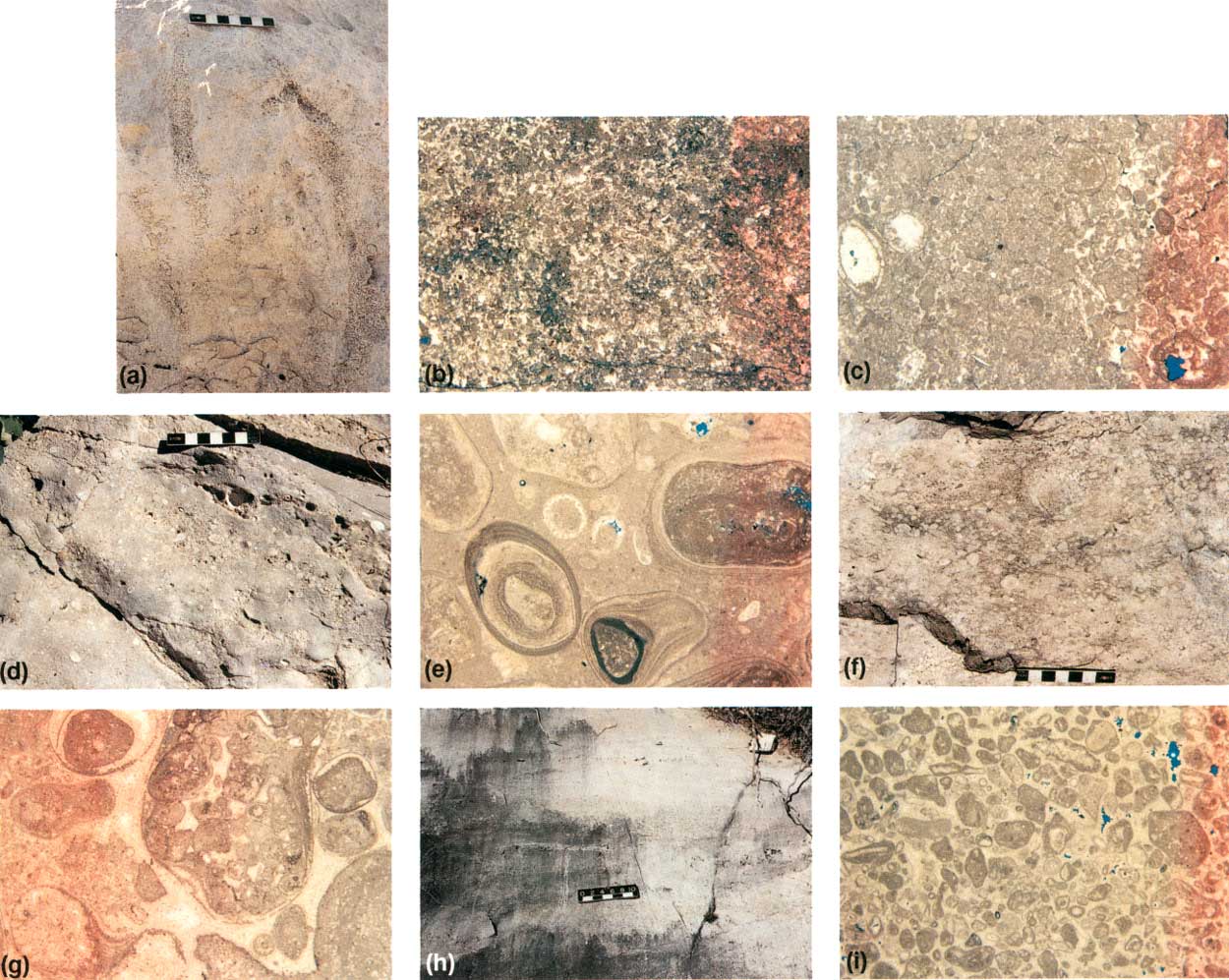
| FIGURE 42. Outcrop and thin-section photographs of Stop 25 outer-shelf cycle (illustrations located on figs. 40 and 43), (a) outcrop photograph showing vertically burrowed peloid-algal packstone (b) photomicrograph of peloid-algal packstone shown in (a), (c) photomicrograph of peloid-algal packstone with well-preserved Mizzia at top of the upward-coarsening outer-shelf cycle in a downdip position with micritic coatings on larger grains, minor cloudy fibrous calcite as first-generation cement, and blocky calcite filling intraskeletal and interparticle porosity, (d) sheet-stratified pisolite packstone in lower portion of outer-shelf cycle in a more shelfward position than in a-c, (e) photomicrograph of (d) showing coarse pisolite-skeletal packstone, skeletal grains include Mizzia and mollusks, pisolites have large nuclei and relatively thin cortices, (f) outcrop photograph of pisolite grain-stone in middle of outer-shelf upward-coarsening cycle, (g) photomicrograph of (f), pisolites are similar to those of (e), interparticle porosity filled primarily by isopachous fibrous calcite, (h) outcrop view of low-angle cross-stratified skeletal grainstone at the most landward point of this cycle exposed on the trail, (i) photomicrograph of coated-grain grainstone with well-developed isopachous-fibrous calcite and blocky calcite cement. Note that the grainstone fabric is coarser grained and better sorted than the cycle-capping packstone of (c). (click on image for an enlargement in a new window) |
A key aspect of Stop 25 is that a single outer-shelf fall-in bed can be traced along the trail seaward to landward up the trail (figs. 34, 40, and 41), thus allowing observations of lateral facies changes within a cycle. As the trail follows this single cycle from the reef toward the shelf crest, an accompanying coarsening of grain size reflects an increase in energy of the depositional environment with progressive shoaling (fig. 42a and 42c vs. fig. 42f and 42g, and fig. 43). Bioturbation gives way to cross-stratification in medium-scale, low-angle, tabular-planar to wedge sets (compare fig. 42a and 42h and fig. 43). Grain size and sorting also increase updip (fig. 42i). More of the grains are pisoids interpreted to have been derived from the pisolitic shelf crest by storm surges directed offshore (fig. 42d-g). This transect also displays the basinward-sloping geometry of these outer-shelf strata as the trail climbs vertically some 9 to 12 m (30 to 40 ft) between downdip and updip portions of Stop 25 (fig. 40). All facies changes described above occur in the relatively laterally condensed dip distance of 140 m (450 ft) (fig. 43).
|
| FIGURE 43. Schematic facies patterns seen in outer shelf fall-in beds of Stop 25. Lateral change occurs from massive to vertical burrowed packstone in a more basinward position, changing updip (uptrail) into pisolite-rich packstones and eventually into cross-stratified carbonate grainstone and/or pisolite grainstone. This change reflects a dip-oriented change in sediment source and depositional energy. (click on image for an enlargement in a new window) |
In summary, the topographic sloping character of an individual fall-in bed can be observed as it passes from the shelf toward the reef, as can a distinctive upward-coarsening of fabrics within a cycle from burrowed packstones lacking pisoids to cross-stratified grainstones with increasing amounts of pisoid grains. The shallowing of facies as this cycle is traced from the reef toward the shelf crest, or up a fall-in bed, suggests that at this time the reef was not the crest of the shelf profile (fig. 43). If the marginal mound or fall-in model of the Capitan profile is correct (fig. 4), then a minimum 12 to 15 m (40 to 50 ft) fall of sea level is recorded by the exposure surface observed at Stop 24 that brought peritidal facies into proximity with the reef (assuming shelf crest to reef relief of 12 to 15 m [40 to 50 ft]) (Hurley, 1989; Borer and Harris, 1991).
STOP 26. Mixed Siliciclastic/ Carbonate
Outer-Shelf Cycles
Where the trail crosses the ledge-forming top of the outer-shelf cycle of Stop 25 just above the 6,900-ft marker (fig. 34), the next 8.5 m (28 ft) of section displays two distinctive sandstone-based skeletal-peloid dolopack-stone cycles (figs. 35, 41, and 44a). These two recessive sandstone beds are used to define the top of the Yates Formation (Hayes and Koogle, 1958; Hayes, 1964) and are easily traced laterally in exposures of the shelf strata (figs. 34 and 41). On the basis of stratigraphic position, the sandstones are probably equivalent to the sandstone beds of the Triplet unit of the Walnut Canyon area (Esteban and Pray, 1977; Neese and Schwartz, 1977; Borer and Harris, 1989; Candelaria, 1989; Neese, 1989). The sandstones are best observed in the cliff exposures (figs. 40 and 44a) but are present along the trail as flaggy-bedded, low-relief exposures.
|
| FIGURE 44. Outcrop and thin-section photographs of Stops 26-28 siliciclastic-carbonate and carbonate cycles: (a) outcrop view of parts of two sandstone-based cycles of the uppermost Yates Formation (equivalent to Triplet unit of Yates in Walnut Canyon; Candelaria, 1989; see fig. 35), (b) photomicrograph of bivalve- and bryozoan-bearing siltstone with abundant moldic porosity after feldspar and mollusks filled with nonferroan blocky calcite spar, (c) cm- to mm-laminated dolomitic siltstone in upper part of cycle shown in (a), (d) characteristic recessively weathered to erosionally resistant profile of upward-coarsening, outer-shelf carbonate cycle in basal Tansill Formation, (e) photomicrograph of peloid grainstone from cross-stratified uppermost interval on cycle shown in (d), (f) gastropod-sponge wackestone locally developed in lows between tepee structures near top of trail marking transgressive surface within the Tansill 1 sequence (see fig. 34), (g) photomicrograph of dasycladacean packstone with abundant moldic porosity at crest of trail. (click on image for an enlargement in a new window) |
Basal sandstone beds are rich in mollusk and bryozoan fragments (fig. 44b). Moldic pores after feldspar and small carbonate grains occur in the sandstones; authigenic kaolinite and blocky calcite spar are abundant. Parallel lamination is characteristic of the sandstone beds (fig. 44c). Upper carbonates of these cycles are massive dolopackstones containing mollusks, green algae, and peloids.
These sandstone/carbonate cycles are most characteristic of the final stages of platform progradation in the Permian deposits of the Northwest Shelf, wherein siliciclastic-dominated facies tracts of the middle shelf have prograded to a position proximal to the basin margin. In this shelf-margin proximal position, only minor base-level fluctuations are required for siliciclastics to reach and bypass the outer shelf. Newell and others (1953) demonstrate that sandstone-dominated shelf equivalents of the lower Yates (their Yates A) member have prograded to a point only 2.9 km (1.8 mi) shelfward of the mouth of McKittrick Canyon. Borer and Harris (1991), working in the subsurface Yates Formation of the Northwest Shelf and western edge of the Central Basin Platform, demonstrated that this carbonate-to-sandstone facies transition prograded at least 2.4 km (1.5 mi) seaward during Yates deposition. If this observation is applied to the McKittrick Canyon area, the sandstone-dominated middle-shelf facies tract equivalent to the uppermost Yates Formation on the trail possibly occurs less than 0.8 km (0.5 mi) updip from this position at the mouth of McKittrick Canyon.
STOP 27. Shelf-Crest Cycles
Above the second sandstone-based cycle of Stop 26, which marks the top of the Yates Formation, the trail affords partial exposures of three carbonate cycles of the lowermost Tansill Formation that are included here in the Yates-Tansill sequence (fig. 35). The 26 m (85 ft) of Tansill traversed here illustrates evidence of initial upward-increasing subaerial exposure and development of sheet cracks and tepee structures followed by marine transgression (fig. 35). Lower Tansill strata below the Ocotillo siltstone have been correlated biostratigraphically with the Lamar Limestone Member of the Bell Canyon Formation (Tyrrell, 1969) that occurs lower on the trail.
Tepee structures in these cycles are well exposed in the cliffs above Stop 26 (fig. 40), but they are not crossed by the trail until near and beyond switchback J (fig. 34). The lower of the three cycles is well exposed in the first good outcrop beyond Stop 26 and shows an upward-coarsening trend from massive, recessively weathered dolopackstones (fig. 44d) through erosionally resistant, low-angle cross-stratified, intraclast-peloidal dolograin-stones to fenestral laminites with small tepee structures (figs. 35 and 44e).
|
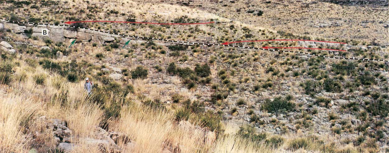
| FIGURE 45. Trail photograph of margin of slope gully at Stop 29. The left side of the photograph is the central part of the amphitheater with a thick section of burrowed wackestone (B). The burrowed wackestone thins to the northeast, and the top of the unit (dashed line) has an anomalously steep dip. Individual beds also thin to the northeast (near green arrow). The burrowed wackestone is onlapped by thick-bedded skeletal-intraclast and skeletal packstones (red lines) at red arrows. (click on image for an enlargement in a new window) |
From switchback J (fig. 34) to the ridge crest the trail exposes the final 9 m (30 ft) of section containing two shelf-crest cycles dominated by fenestral laminites with tepee structures. Outcrops of the upper of these two cycles near the 7,000-ft marker show tepees with crests with up to 1.5 m (5 ft) of relief. Ponding of the basal packstone of the overlying cycle in low areas between tepee structures resulted in a highly variable thickness of this cycle-base, marine subtidal facies. Skeletal dolowackestone/packstone, with sponges, Collenia sp., and belerophont gastropods, occurs locally in tepee-depression areas on the trail (fig. 44f).
A series of 0.2- to 0.3-ft-wide (0.5- to 1-ft) dikes oriented parallel to the shelf-margin also occur in the immediate vicinity of switchback J. One dike is filled with Tansill-equivalent skeletal detritus and laminated quartz silt and is either a neptunian dike or Tansill-age karstic grike (solution-enlarged dike). Two other dikes, one at switchback J and one near the crest of the trail, are filled with lithoclastic breccia in a red, siliciclastic-rich, dolomitic matrix. These features are interpreted to be karstic grikes, but timing of formation, whether Permian or Tertiary, is in question.
STOP 28. Outer-Shelf Dolopackstone
The remaining 6 to 9 m (20 to 30 ft) of section exposed at the top of the trail is mollusk-algal dolopackstone of the Tansill Formation with rare sponges (figs. 34, 35, and 44f). Samples contain abundant large specimens of dasycladacean algae, mollusks, and spicules (fig. 44g). Some grains are micritized, and isopachous fibrous calcite cements and moldic pores occur locally. This dolopackstone is interpreted to mark the gradual return to outer-shelf conditions in successively younger Tansill strata. This transgressive phase of sedimentation in the lower Tansill Formation also appears in both Walnut and Dark Canyons (Neese, 1989; Parsley and Warren, 1989) and marks the base of the Tansill 1 sequence (fig. 35).
Summary
From the crest of the Permian Reef Geology Trail, excellent views are provided along the reef trend to the northeast and down into the basin to the southeast. In the near foreground to the northeast is the southwest-facing wall of Big Canyon, where the near-terminal shelf profile of the Capitan is defined by Tansill/Capitan/Lamar strata. The northward regional dip of the entire platform in the direction of White's City and Carlsbad, where it is finally in the subsurface, is also well demonstrated. The present-day geomorphic top of the platform, which approximately follows the lower Tansill in this view, drops from 2,130 m (7,000 ft) at the trail crest to 1,160 m (3,800 ft) at the farthest visible point of the reef, some 40 km (25 mi) away (average regional dip of ~1°)
The depositional profile of the Lamar toe of slope to basin is viewed by looking basinward across McKittrick Creek and the entrance road to the south. Basinward along the north side of the creek is the Lamar escarpment, which is composed of the Lamar preserved in near-original depositional geometry. Smooth slopes behind the McKittrick Canyon Visitor Center that can be traced upslope on the south wall of the canyon are also of Lamar toe-of-slope deposits. These strata have been truncated about a third of the way up the Capitan slope by present-day erosion.
| <<< Previous | <<< Contents >>> | Next >>> |
state/tx/1993-26/sec4.htm
Last Updated: 2-Apr-2007