
|
Texas Bureau of Economic Geology
Guide to the Permian Reef Geology Trail, McKittrick Canyon, Guadalupe Mountains National Park, Texas |
GEOLOGY LOOP TRAIL
Alton Brown and Robert G. Loucks
The Geology Loop Trail description begins at the upper end of the loop, 1 km (0.6 mi) up the Permian Reef Geology Trail from the Visitor Center, and ends at the lower end of the loop (fig. 8 inset). The Geology Loop exposes lateral changes in depositional facies in a toe-of-slope setting thought to be evidence of a slope gully during deposition of the Lamar Limestone Member of the Bell Canyon Formation.
About 110 m (360 ft) north of its uptrail junction, the Geology Loop Trail bends to the north and then descends into a small arroyo ringed with outcrops, thus forming a natural amphitheater (fig. 45).
STOP 29. Margin of Slope Gully
The resistant beds ringing the west side of the arroyo (figs. 8 and 45) are burrowed wackestones correlative with the burrowed wackestone in the upper part of Stop 4. The underlying thin-bedded wackestone, recessively weathered peloidal packstone, and interbedded skeletal packstone and thin-bedded wackestone units at Stop 4 are also present here, but they are poorly exposed.
The top of the burrowed wackestone unit displays a northeasterly dip (~5°) significantly steeper than the regional structural dip (2°). The burrowed unit and individual beds within the unit thin to the northeast. On the northeast end of the low cliff, the thinned burrowed wackestone unit is onlapped from the north by thick-bedded intraclast packstones (fig. 45). These are overlain by poorly exposed skeletal packstones and skeletal-intraclast packstones. These lateral changes are interpreted to mark the southwestern edge of a syndepositional slope gully. Thinning of the burrowed beds is interpreted as syndepositional erosion near the edges of the gully. Wackestone truncation and packstone onlap mark the actual margin of the gully. Although clearly defined at some stratigraphic intervals such as this, the gully packstones interfinger with marginal wackestone deposits higher and lower in the section.
As the trail descends into the next arroyo, it intersects thin-bedded wackestone correlative to the upper thin-bedded wackestone at Stop 4. A few tens of feet farther down the trail at approximately the same stratigraphic position, these beds are replaced by thick-bedded, skeletal and intraclast packstones deposited by debris flows, marking the edge of the slope gully at a lower stratigraphic position.
STOP 30. Slope Gully Fill
Good exposures of the gully fill crop out in the arroyo where the trail bends sharply to the right (fig. 45). The lithologies seen in these exposures are similar to the grainy facies seen along the Permian Reef Geology Trail at Stops 3, 6, and 7. The two prominent intraclast packstone beds cut by the trail and the thick-bedded, skeletal intraclast packstone on the arroyo floor are interpreted to be debris-flow deposits. The lower part of the northeast wall of the arroyo comprises thin- to medium-bedded, graded packstones to grainstones interpreted to be turbidites. These turbidites are overlain by thin-bedded, sparsely burrowed wackestones, which are in turn overlain by thick-bedded intraclast packstones. Higher in the section, a 0.3-m-thick (1-ft) burrowed wackestone is interbedded with the intraclast packstones. Some channelized beds within the gully fill contain small Archaeolithoporella boundstone fragments. The upsection increase in burrowing intensity of the wackestones at Stops 4 and 29 outside the gully are observed in the wackestone beds intercalated with gully packstones. The change in fabrics occurs at approximately the same stratigraphic position in the gully as that outside the gully, indicating that deposition of the gully fill occurred concurrently with deposition of wackestones southwest of the gully.
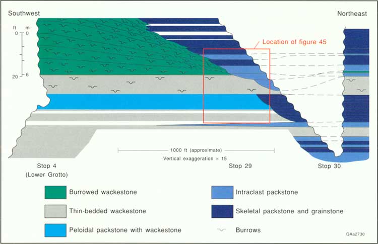
The schematic cross section connecting Stops 4, 29, and 30 summarizes relationships of the southwestern gully margin (fig. 46). Wackestone and peloidal packstone strata are relatively continuous between Stop 4 and the southwestern end of Stop 29. From Stops 29 through 30, the gully packstones interfinger with and substitute for wackestones occurring at the same stratigraphic position. The gully was characterized by gentle bathymetric relief and penecontemporaneous deposition of grainy units within the gully and muddy units on the margin of the gully.
|
| FIGURE 46. Schematic strike cross section between the lower Grotto (Stop 4) and Stop 30. Area of figure 45 is indicated by the inset box. Slope northeast of Stop 30 (section I) is steepened to shorten cross section. (click on image for an enlargement in a new window) |
About 69 m (225 ft) down the trail, the updip end of a grainstone- and intraclast packstone-filled channel is exposed at eye level across the arroyo from the trail. To the right of the trail in a small drainage channel, thick-bedded packstones contain excellent silicified brachiopods, mollusks, and bryozoans.
A short distance beyond this point, the limestones grade from grain-rich to mud-rich as the trail obliquely leaves the slope gully. The transition is marked by changes of bedding dip and enhanced slump deformation. The slope gully continues to the east boundary of the park. Where the trail diverges from the arroyo, most of the limestones at trail level are laminated wackestones, which occur along the remainder of the Geology Loop Trail to its lower intersection with the Permian Reef Geology Trail.
| <<< Previous | <<< Contents >>> | Next >>> |
state/tx/1993-26/sec5.htm
Last Updated: 2-Apr-2007