
|
Washington Department of Natural Resources
Geology and Earth Resources Division Information Circular 90
Flood Basalts and Glacier Floods: Roadside Geology of Parts of Walla Walla, Franklin, and Columbia Counties, Washington
Robert J. Carson and Kevin R. Pogue
|
Road Logs
PART 5 - WALLULA GAP TO WALLA WALLA
| Miles |
|
| 162.2 |
STOP 12: Mazama ash at Oregon-Washington
state line (Fig. 59). Park on the right (southeast) side of U.S. 730.
Be alert for traffic and rattlesnakes.
Between the basalt cliffs and the Columbia River are
talus slopes and alluvial fans that have formed since the passage of the
last Missoula flood about 12,700 years ago. This alluvial fan was partly
covered by a debris flow about a decade ago; notice the boulders,
particularly near the head of the fan. The channel on the alluvial fan,
partly created by the Washington highway department, reveals about 3 m
of Mazama ash and fan sediments. Mount Mazama underwent a catastrophic
eruption and caldera collapse 6,845 years ago that resulted in Crater
Lake (more than 400 km away in Oregon's southern Cascades) (Bacon,
1983). A thin blanket of tephra fell on the Horse Heaven Hills and as
far northeast as Alberta (Wilcox, 1965). The ash washed off the Horse
Heaven Hills, down gullies, and onto alluvial fans where it was buried
and preserved.
Across the river at the base of the cliffs are more
alluvial fans (Fig. 60). From here the light-colored lenses of Mazama
ash are visible in railroad cuts through the alluvial fans. Gravel bars
(Fig. 60) were deposited by the Missoula floods high in canyons
tributary to the Columbia River here at Wallula Gap.
After passing through Wallula Gap the Missoula floods
poured into the Umatilla Basin and then rushed down the Columbia River
Gorge and inundated the Willamette Valley before draining into the
Pacific Ocean at Astoria (Fig. 5).
Between U.S. Highway 730 and the railroad tracks is a
railroad rockfall warning device designed to alert train engineers if
large rocks fall from the cliffs or down the talus slopes. The wire
fence here has a mesh size such that small rocks may pass through and
land between the tracks. Any rocks large enough to obstruct passage of a
train would hit the fence and send an electrical alert signal to trip a
semaphore to stop the train.
Continue northeast on U.S. Highway 730, returning to
Wallula Junction.
|

|
|
Back Cover. Route of the field trip. Stop locations are indicated by the
circled numbers. (click on image for a PDF version)
|
|

|
|
Figure 59. Alluvial fan and talus at the
Washington-Oregon state line. The cliffs are basalt flows of the
Frenchman Springs Member. Below the cliff is talus covered with grass.
In the foreground is a channel in an alluvial fan. At the bottom of the
channel is Mazama ash (white) from the eruption at Crater Lake about
6,845 years ago. Overlying the ash is alluvial gravel at the surface of
the fan.
|

|
|
Figure 60. West side of Wallula Gap near the
Washington-Oregon border. To the right and left are ledges of
Columbia River basalts. In the center is a giant eddy bar deposited by
the Missoula floods. The vertical distance from the bottom of Lake
Wallula to the top of the eddy bar (170 m) is the minimum water depth of
the Missoula floods; some of the floods were about 275 m deep. A large
gully in the eddy bar leads down an alluvial fan in the lower right. The
light patches in the fan are Mazama ash from Crater Lake, Oregon.
|
|
| 168.1 |
Wallula Junction. End of U.S. Highway 730.
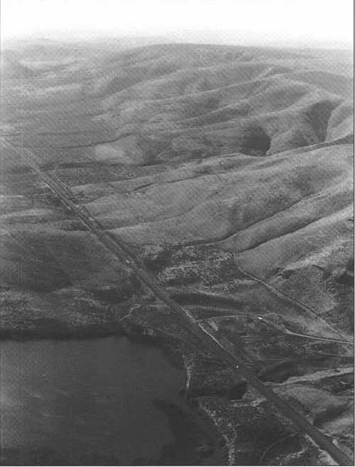
Proceed east on U.S. Highway 12 toward Walla Walla. On the right (south)
side of U.S. 12 is a row of about a half dozen faceted spurs along the
Olympic-Wallowa lineament (Figs. 53 and 61). The faceted spurs are
truncated ends of ridges between the gullies that were cut by the
intermittent streams that flow north off the Horse Heaven Hills: each
truncated spur is a triangle about 100 m high.
|
|
|
Figure 61. Olympic-Wallowa
lineament (or OWL) east of Wallula Gap. Truncated spurs along the
lineament are visible in this view toward the east-southeast. This
Horse Heaven Hills anticline is on the upthrown (right) side of the OWL.
In the lower left is part of the delta of the Walla Walla River.
|
|
| 171.1 |
Across the road from the Wallula Habitat
Management Unit sign, a 1-cm-thick bed of Mount St. Helens set S tephra
is exposed in Touchet Beds; this tephra is about 13,000 years old
(Mullineaux and others, 1978). Mount St. Helens ash did not fall this
far south on May 18, 1980; distribution of ash is controlled by the
prevailing winds at the time of the eruption.
|
| 172.5 |
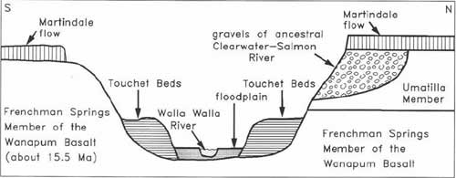
The Walla Walla River is meandering across its
flood plain in the lower Walla Walla Valley. On the north side of the
valley are exposed lava flows of the Frenchman Springs Member (15.5
m.y. old) of the Wanapum Basalt and the Umatilla Member (about 14 m.y.
old) and Ice Harbor Member (Martindale flow)(about 8.5 m.y. old) of the
Saddle Mountains Basalt (Swanson and Wright, 1981). (See Fig. 62.) The
ancestral Clearwater-Salmon river system cut a valley in the
Umatilla basalt and partly filled that valley with basaltic,
metamorphic, and plutonic clasts. At about 8.5 m.y. ago, the Martindale flow
of the Ice Harbor Member capped the sequence (Fecht and others,
1987).
The drainage system of the Walla Walla River was
established by the late Miocene to middle Pliocene (Fecht and others,
1987, p. 240). The oldest unconsolidated deposits in the Walla Walla
Valley are termed the "old gravel and clay" (Newcomb, 1965, p. 20-22).
In the late Pleistocene, the Missoula floods partially
filled the Walla Walla Valley with Touchet Beds. In the
Holocene, the river has partially excavated these beds, forming a
flood plain and locally cutting down to the basalt
bedrock.
|
|
|
Figure 62. Cross section of the lower Walla Walla River valley. The
Umatilla Member (between 14.5 and 13 m.y. old) and the Martindale
flow of the Ice Harbor Member (8.5 m.y. old) belong to the Saddle
Mountains Basalt.
|
|
| 174.6 |
Bridge over the Walla Walla River at Reese (elevation
389 ft). Roadcuts from here to the top of the hill are in the Frenchman
Springs Member of the Wanapum Basalt (Swanson and Wright, 1981).
There is an area of channeled scabland near the hill
just southeast of here (elevation 716 ft) and the hill at Divide. There
are small buttes, or scabs, of basalt and shallow coulees with
southeasterly orientations. The erosion that shaped this area occurred
as the Missoula floods overtopped the hills as they poured from the
Pasco Basin into the main Walla Walla Valley. With flood levels at
1,200 ft, there was 150 m (500 ft) of water flowing over these
hills.
|
| 176.0 |
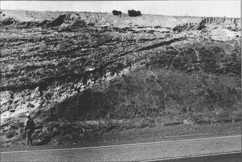
STOP 13: Unconformities at Divide (Figs. 63 and 64).
Park at the east end of the roadcut and walk back down the hill. Be
alert for traffic.
This is the crest of a north-trending anticline at
the west edge of the main Walla Walla Valley (Swanson and Wright, 1981).
The Frenchman Springs Member of the Wanapum Basalt is overlain by poorly
sorted and crudely stratified caliche-rich strata. Almost all the clasts
are basalt, but at least two weathered erratics (one granite and one
gneiss) have been discovered near the base of the sediments.
Vrooman and Spencer (1990) interpret these sediments
as the remains of two debris flows that were covered by colluvium
(talus), loess, and, finally, a soil. According to their scenario,
there would have been a hill of basalt just to the east of these
sediments. An ancient jökulhlaup left one or more icebergs that were
transporting the erratics on the hill. Mass wasting of the western
hill slope brought the erratics downslope into the diamictons. The
geomorphology, the presence of weathered erratics, and the degree of
development of the caliche all suggest great age, perhaps several hundred
thousand years, for these Pleistocene diamictons.
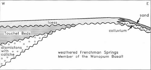
Overlying the diamictons and the basalt are about a
dozen thin Touchet Beds deposited by the late Pleistocene Missoula
floods (Fig. 63). Holocene eolian sediments (mostly loess, but some
sand) cap the section.
To the north of the highway are iceberg-transported
cobbles and boulders. Walk a short distance (50-100 m) north from the
west end of the roadcut to see a variety of iceberg-transported erratics
(granite, gneiss, quartzite, sandstone, and siltstone). Bartlett and
Carson (1995) reported on a bergmound located 10 km southeast of here.
They estimated that the pile of large boulders had been deposited by an
iceberg with a volume of 6,000-12,000 m3 (200,000-400,000
ft3).
Here at Divide is evidence for glacial flooding not
only in the late Pleistocene but also much earlier in the Pleistocene.
The evidence for late Pleistocene jökulhlaups from glacial Lake
Missoula is twofold: (1) Touchet Beds near the top of the exposure and
(2) erratics at the surface. The evidence for jökulhlaups earlier in
the Pleistocene consists of the erratics near the base of the
diamictons.
Vrooman and Spencer (1990) interpret the diamictons
as follows:
"The lowermost unit consists of a fining-upward
diamicton. Large clasts are basaltic except for a few clasts of exotic
lithology. Textural parameters suggest deposition by a mudflow, or
colluviation concurrent with deposition of loess. A truncated clastic
dike in this unit indicates a period of erosion before deposition of
the overlying units, which are coarser-grained and caliche-rich.
Texturally, these upper units, in which exotic lithologies are lacking,
suggest colluvium deposited as a nearby basaltic high weathered and
mass-wasted. The upper, caliche-bearing portion of these units is
fine-grained, suggesting a period of loess deposition. The presence of
caliche indicates that colluviation was followed by long periods of
soil development; based on the apparent stage of development, each
caliche horizon may represent a minimum of 5-10 Ka, and perhaps
considerably more."
The evidence for two distinct ages of flooding is an
example of the principle of uniformitarianism, which geologists
sometimes state as "the present is the key to the past." On this hill
today are basalt outcrops, loess, and erratics from the latest glacial
Lake Missoula floods. With time, these materials will creep (a
type of slow mass wasting) down the hill, and a soil containing caliche
will form. Evidently, this is what happened earlier in the Pleistocene,
with the result that the erratics were buried, preserving the evidence
for the ancient floods.
Return to your vehicle and continue east on U.S.
Highway 12. To the south are the Horse Heaven Hills anticline and fault
scarps of the Wallula fault zone. To the east is the much larger
Blue Mountains anticline; this northeast-trending
anticline is composed mostly of the Columbia River Basalt Group.
However, erosion at the crest and in some deep canyons has resulted in
limited exposures of Mesozoic granitic rocks and of parts of accreted
terranes of mostly Mesozoic metamorphic rocks (Fig. 15).
|
|
|
Figure 63. North roadcut at Divide. In the lower
portion of the caliche-rich diamictons are rare granitic and metamorphic
erratics.
|
|
|
Figure 64. Unconformities at Divide (Stop 13). To the
man's right is weathered basalt of the Frenchman Springs Member. Above
the unconformable contact (at the level of the man's head) are crudely
stratified diamictons dipping to the west. The diamictons are rich in
caliche and have sparse erratics near the base. Unconformably overlying
both the basalt and the diamictons are a few thin Touchet Beds deposited
by late Pleistocene Missoula floods. The sequence is covered with about
1 m of Holocene loess.
|
|
| 179.9 |
Cross the Touchet River
(near its confluence with the Walla Walla River), then enter Touchet
(elevation 443 ft). To the south, on the left bank of the Walla Walla
River, is the type locality for the Touchet Beds (Flint, 1938). (There
are still better exposures at Stop 14.)
|
| 180.6 |
Near the east end of Touchet, turn left (north)
on Touchet Road (or Touchet River North Road).
|
| 183.1 |
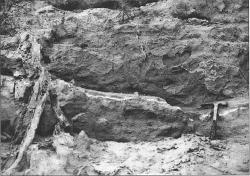
At the south end of the roadcut in Touchet Beds
is exposed Mount St. Helens set S tephra (Fig. 65). In places there are
two closely spaced thin ash layers, suggesting that the eruption pattern
of 13,000 years ago was somewhat like that of 1980—multiple
eruptions over a period of time. In 1980, winds distributed ash from
Mount St. Helens eruptions as follows: May 18, east-northeast; May 25,
northwest; June 12, southwest; July 22, northeast; August 7,
north-northeast; October 16-18, southwest (and southeast)
(Sarna-Wojcicki and others, 1981). The result was partial geographic
overlap of multiple ash falls. Between the thin set S ash layers is a
few centimeters of eolian silt, or possibly sheet wash sediment (Waitt,
1980, p. 664-667; 1985, p. 1273).
|
|
|
Figure 65. Mount St. Helens ash (approximately 13,000 years old) in
Touchet Beds north of Touchet. The layer of white Mount St. Helens set S
tephra, about 1 cm thick, lies near the top of a Touchet bed. On the
left is a clastic dike.
|
|
| 183.5 |
STOP 14: Touchet Beds and clastic dikes. Park
on west side of road. Beware of black widow spiders at this stop.
Although the Touchet Beds were originally believed
to represent only two major floods (see review in Carson and others,
1978), most geologists now believe (see, for example, Waitt, 1980,
1985) that each Touchet bed represents one jökulhlaup or glacier
outburst flood. Waitt (1980, 1985) has found considerable evidence that the
Touchet Beds were deposited by dozens of Missoula floods. Between some
flood-deposited rhythmites are slope wash sediments in channels,
loess, volcanic ash, rip-up clasts (material pried loose
from underlying sediments), and clayey lacustrine beds. Further
evidence for a significant amount of time between successive floods
includes rodent burrows and reworked shells and vertebrate
remains—proof that animals were living in and on the Touchet Beds
between these floods (Waitt, 1980, p. 668).
According to Waitt (1987, p. 345), "floodwater backed
up dead-end valleys off the main Scabland floodways to form transient
ponds in which suspended load settled. Because the side valleys were
protected from violent currents, flood-laid strata were not eroded by
later floods but became buried and preserved."
Spencer (1989) compared the sedimentology and
paleontology at this stop and at the 'Little Grand Canyon' near Lowden
(see mile 190.4). The Little Grand Canyon is in the middle of the Walla
Walla Valley, but here the Touchet valley is narrower and has a higher
elevation and a steeper gradient. Compared with those in the Little
Grand Canyon, the graded rhythmites at this stop are poorly developed.
More rapid drainage at this site resulted in more vigorous post-flood
erosion and removal of the finer upper part of the rhythmites here. At
this site Spencer (1989) found rodent fossils (including ground
squirrel, vole, and kangaroo rat) and burrows indicating colonization by
small animals between flood episodes.
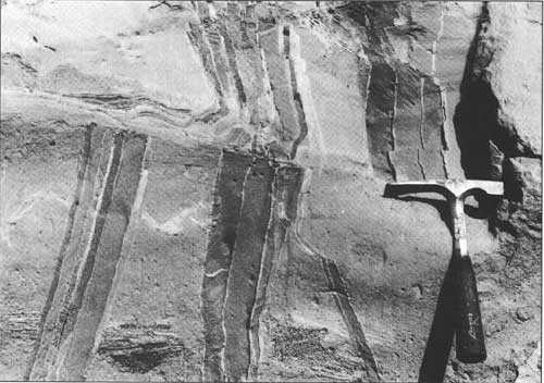
The clastic dikes range in thickness from millimeters
to meters and have various strikes and dips—most large ones are
nearly vertical. Many consist of alternating vertical laminae of silt
and sand (Fig. 66). There are many proposed origins (summarized from
Carson and others, 1978): earthquake fissures, cracks that formed as
buried ice melted, fissures due to erosion by underground streams,
landslide fissures, permafrost-related crevices, desiccation fractures,
ground-water injection, and extensional fractures accompanying slumping
of unstable rapidly deposited turbidites.
Black (1979) studied the clastic dikes in the Touchet
Beds and other geologic material in the Pasco Basin. Most dikes there
"are megascopically similar in texture, fabric, and relation to their
host." They "display the pronounced vertical layers of sand and silt,
and have thick clay and silt coatings separating them and lining the
walls of the host. The bulk of the material came down from above
aperiodically as openings were enlarged underwater" (Black, 1979, p.
55).
Black (1979) concluded that the clastic dikes do not
all have the same origin. However, for most of the dikes, he
"hypothesized that hydraulically dammed Pleistocene floodwater that
repeatedly covered the Pasco Basin is primarily responsible for the
initial fracturing, for the aperiodic widening, and for the primary
source of sediments that filled the fractures" (Black, 1979, p. 61).
While most of the dikes were
filled from above, some small dikes were produced when liquefied layers
of sediment were injected into overlying layers. Sudden loading by a
Missoula flood or earthquake vibrations may have caused the
unconsolidated sediment below the water table to liquefy. The weight of
the overlying sediments forced the liquefied sediments to intrude
upward to form the dikes.
Turn around. Drive south down the Touchet valley.
|
|
|
Figure 66. Clastic dikes in Touchet Beds north of Touchet (Stop 14).
Although there are many small dikes and faults at this exposure, here
are two subvertical clastic dikes offset about 0.5 m by a subhorizontal
fault. The clastic dikes have vertical laminae of alternating sand and
silt.
|
|
| 186.4 |
In Touchet, turn left (east) on U.S. Highway
12. All roadcuts between here and Walla Walla expose Touchet Beds.
The Battle of Walla Walla was fought in December
1855; the Oregon Militia and the Walla Walla Indians had a 4-day
skirmish from here up the Walla Walla River to Mill Creek (Majors,
1975).
|
| 190.4 |
Cross Dry Creek and enter Lowden (elevation 489
ft). To the south is a hill of Touchet Beds, an erosional remnant left
as the Walla Walla River cut its flood plain.
Three kilometers to the south is the Little Grand
Canyon. The canyon is on private property and entry without permission
is forbidden. Because of the potential danger at the Little Grand
Canyon, if you plan to visit the site you must have liability
insurance specific to this site and a notarized hold-harmless
agreement. For information, contact Stuart Durfee,
Secretary/Manager, Gardena Farms District No. 13, Box 137, Touchet, WA
99360 (509-394-2331).
The Little Grand Canyon (Figs. 67 and 68) cuts the
south side of the ridge visible to the south. The ridge is part of an
extensive but dissected surface that slopes gently down the Walla Walla
Valley. The surface is at 800 ft just west of College Place, 625 ft
here, and 500 ft southwest of Touchet. This surface is the top of the
Touchet Beds, with about a meter of loess added. In other words, the
surface is the bottom of the intermittent lake that aggraded during
each Missoula flood. The surface has been dissected by the Walla Walla
River and its tributaries.
Along the crest of the ridge runs the Burlingame
irrigation ditch. This ditch is fed by a diversion structure near Mile 36
of the Walla Walla River (southwest of College Place).
The history of the formation of the Little Grand
Canyon is summarized from Soil Conservation magazine (December
1935, p. 14-15). In 1904, a diversion canal was built from Burlingame
irrigation ditch south to Pine Creek; the purpose was to control
discharge in Burlingame ditch, especially when spring winds pile enough
tumbleweeds into the ditch to choke the water flow. Until March 1926,
the diversion canal was a gully about 10 ft deep and 6 or 8 ft wide.
Then for 6 days steady winds caused enough tumbleweeds to accumulate to
force the entire 80 ft3/s (2 m3/sec) flow of
Burlingame ditch into the diversion canal. The water soon eroded
4,725,000 ft3 (134,000 m3) of Touchet Beds.
In 1927, an overshot flume was constructed to
prevent further headward erosion. The flume collapsed into the canyon and
another was built. Within a decade the canyon was 100 ft (30 m) wide
and as much as 120 ft (36 m) deep. The Soil Conservation Service
calculated that 9,588,000 ft3 (271,000 m3) of
earth had been removed, and engineers recommended that a wooden flume be
constructed around the gully.
The Touchet Beds exposed in the walls of the Little
Grand Canyon (Fig. 48) have been studied many times. (See Carson and
others, 1978, for review; Bjornstad, 1980; Waitt, 1980, 1985, 1987;
Spencer, 1989; O'Connor and Waitt, 1994.) For a comparison of the
Touchet Beds in the Little Grand Canyon and those exposed in the lower
Touchet valley, see the description for Stop 14.
|

|
|
Figure 67. 'Little Grand Canyon' south of Lowden.
Approximately 40 rhythmites of the Touchet Beds are cut by clastic dikes
(closeup, top photo). Much of the canyon was eroded in a few days in
1926. (See text for details.)
|

|
|
Figure 68. View northwest of the Little Grand Canyon south of Lowden.
Serious erosion of the Touchet Beds began in 1926; today the canyon is
36 m deep. See text for details. The predominant land use here is
alfalfa seed production.
|
|
| 190.9 |
Leave Lowden. The Blue Mountains anticline
rises above the Walla Walla Valley to the east.
|
| 196.1 |
The road to the Whitman Mission National Historical
Site enters from the right (south). You can see a monument about a
kilometer to the southeast on the west end of a ridge forming the
drainage divide between Mill Creek and the Walla Walla River. The ridge
is composed of Touchet Beds. The Whitmans settled on the flood plain
between the creek and the river. A nearby highway sign reads:
"A short distance to the south near the Walla Walla
River is Waiilatpu, the place of the people of the rye grass, a mission
founded among the Cayuse Indians of the Walla Walla Valley in 1836 by
Dr. Marcus Whitman and his wife Narcissa. As increasing numbers of
immigrants moved into the Oregon country during the 1840s, Whitman
Mission became an important station on the Oregon Trail. Cultural
differences climaxed by a measles epidemic that killed many Cayuse ended
the missionary effort. A few suspicious Cayuse took the lives of Marcus
and Narcissa Whitman and eleven others on November 29, 1847."
|
| 198.1 |
The road to College Place enters from the right
(southeast). When the highway department improved this intersection in
the summer of 1994, new vertical cuts were made in the Touchet Beds and
loess on the left (north) side of U.S. Highway 12. Notice all the holes
in the roadcuts; within days after the new cuts were made, they became
homes for thousands of bank swallows.
|
| 201.7 |
Enter Walla Walla; continue east on U.S. Highway 12.
Walla Walla lies on the flood plain of Mill Creek. Before the Army Corps
of Engineers made a three-pronged attack on Mill Creek there was
occasional severe flooding in Walla Walla, particularly in 1906 and
1931.
That attack includes construction of Bennington Lake,
channelization of Mill Creek through Walla Walla, and small dams to
divert water from Mill Creek into Garrison and Yellowhawk
Creeks that run south of the city. From Bennington Lake,
potentially one of the largest off-stream flood storage projects in the
state (Mills, 1989), water can drain into Russell Creek or back into
Mill Creek. The earth-rock dam for Mill Creek Reservoir has never
been able to hold much water without leaking. Much of the way through
Walla Walla, Mill Creek's channel has concrete sides and bottom. The
creek runs beneath many downtown buildings. Garrison, Yellowhawk, and
Russell Creeks flow into the Walla Walla River. Floodwaters diverted
into these creeks would not re-enter Mill Creek.
|
| 202.9 |
Take Rees Avenue exit from U.S. Highway 12 and
proceed southeasterly.
|
| 203.0 |
Veer southerly on Park Street.
|
| 203.4 |
The Whitman College parking lot is to the left (east).
This marks the end of field trip.
|
state/wa/1996-90/part5.htm
Last Updated: 05-Aug-2011
|


