
|
Geological Survey Water-Supply Paper 1766
The Water Supply of El Morro National Monument |
WHERE THE WATER IS STORED: THE GEOLOGY OF EL MORRO
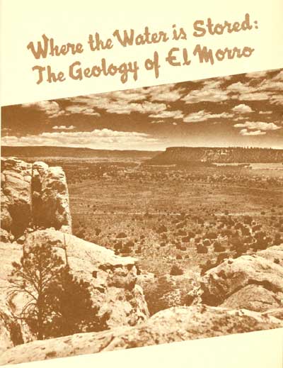 View eastward from top of Inscription Rock. The steep southwest slope of the Zuni Mountains forms the distant skyline; the valley plain is underlain by volcanic flow rocks. |
El Morro National Monument lies in a wild and beautiful region of sheer cliffs, high mesas, steep mountains, and narrow valleys and canyons. The altitude at the monument headquarters is 7,200 feet. North of El Morro, the forest-covered slopes of the Zuni Mountains rise higher, to altitudes of 8,000 or 9,000 feet. Many streams in the Zuni Mountains have carved deep canyons in the slopes. Unfortunately, none of these streams cross the lava plain to run near the monument because all the water sinks into the lava very quickly.
The inscriptions and Indian relics at El Morro are young in comparison with the rocks. The history they record is only an infinitesimal part of the millions of years of history that can be read in the rocks of the region. Through the billions of years of its history, the appearance of the earth has changed many times. The mountains and valleys that we recognize did not always exist where they are now. The crust of the earth has been pushed and pulled by subcrustal forces, which made the crust sink in some places, and rise in others. At places it has been ripped by earthquakes.
In ages past, many of the rocks which now are mountains were formed at the bottom of the sea. We know this because fossil remains of sea animals are found in the rocks on mountain tops. Then powerful forces from within the earth folded and raised these rocks to their present position. As soon as the mountains rose above the sea, however, streams, wind, and glaciers began tearing them down. Billions of tons of sediment (minute particles of rock) were eroded from the land by rivers and added to the oceans or the stream valleys along the way. Some of the particles were whisked about by the winds and accumulated in dunes on the land. As the ocean floor piled up with sedimentary material, subcrustal forces gradually lifted the sediments out of the water until they became mountains, and the process of erosion started all over again (fig. 6).
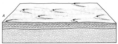 In Precambrian time layers of sediment accumulated and eventually formed rock  The layers of rock were squeezed and crumpled into mountains. Molten rock from below moved upward through cracks and formed volcanoes.  During many millions of years the mountains were worn down by erosion, and a nearly level plain little higher than the sea was left. 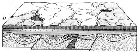 In Paleozoic and Mesozoic time, new layers of sediment accumulated in seas and streams and as sand dunes in broad expanses of deserts. 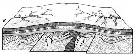 At the end of Mesozoic time the new layers of rocks were bowed upward above the seas in a broad arch that formed the Zuni Mountains. 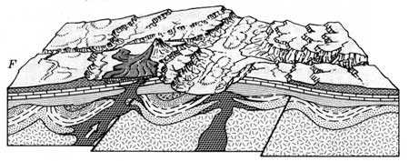 In Cenozoic time, erosion sculptured the landscape as we see it today, modified slightly by new outpourings of lava. |
| Figure 6. The process of mountain building and erosion. |
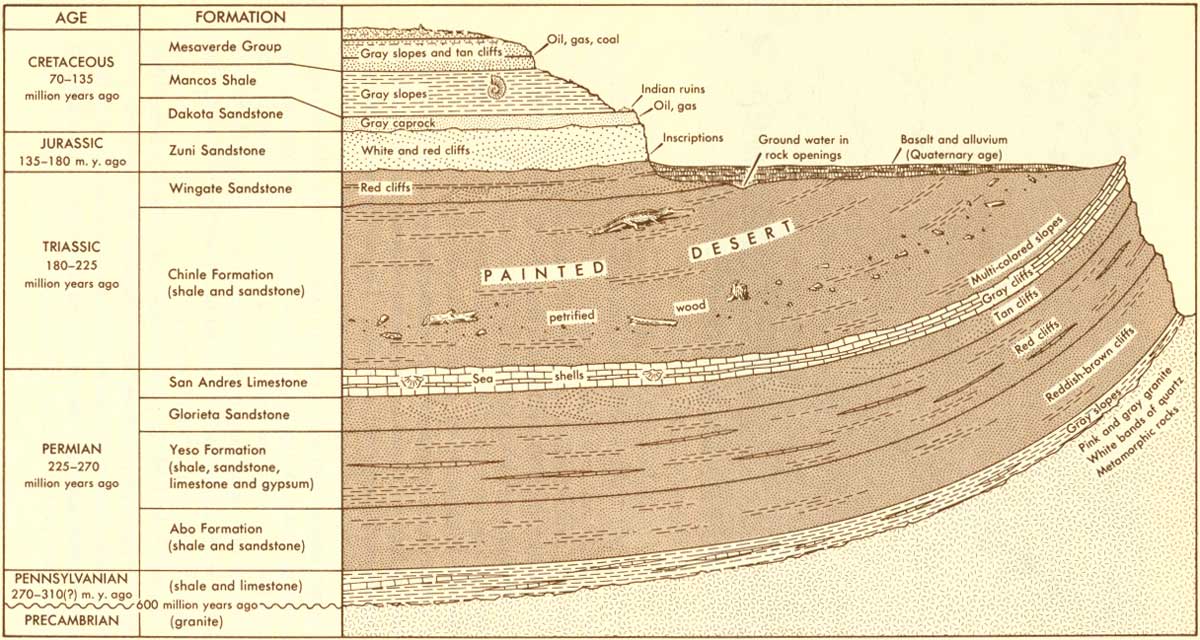
These movements of the earth's crust—the wearing down and the bulging up—have taken place during many million years. At El Morro, some of the sedimentary rocks are almost 300 million years old. The sedimentary rocks lie on a complex system of igneous and metamorphic rocks, which are more than 600 million years old.
The history of the earth can be read in these rocks as clearly as the writing on Inscription Rock. Sedimentary rock is made from materials that have been carried by water or wind to their place of rest and turned into rock. Rain and ice grind rocks into sand and mud, which settles into the bottoms of rivers, lakes, and seas. As this sand and dirt piles up into layers, it is squeezed and pressed into sedimentary rock. Some characteristic sedimentary rocks are sandstone, limestone (rocks made from sea shells), shale (rock made from clay and mud), and pudding stone or conglomerate (mass of different-sized pebbles cemented together).
The word igneous comes from the Latin word for fire. The inside of the earth contains molten rock, or magma. In some places, this magma is closer to the surface than in others, and the molten rocks push through crevices in the earth's crust. This rock, when solidified, is called igneous. Granite, basalt, pumice, and obsidian are igneous rocks. Nearly everyone knows what granite looks like. Basalt is hardened lava, and pumice is the hardened froth from volcanoes. Both basalt and pumice have bubbles or air holes in them. Obsidian looks like dark, heavy glass.
The word metamorphic comes from the Latin word meaning to change or be changed. Metamorphic rocks have been changed by heat and pressure from the way they were originally. They may have begun as igneous or sedimentary rocks, but heat, time, pressure, and sometimes water, have changed the rocks into other kinds. For instance, sandstone is metamorphosed into quartzite; limestone into marble; shale into slate.
All three of these main kinds of rock are present at El Morro. The layers of sedimentary rocks that once were horizontal, or nearly so, have been tilted from their original plane, as in the diagram. The layers of rock are tilted, as though bent by a giant hand (fig. 7). You will learn more about these rocks as you read further.
|
| Figure 7. Tilted layers of rocks at El Morro. (click on image for an enlargement in a new window) |
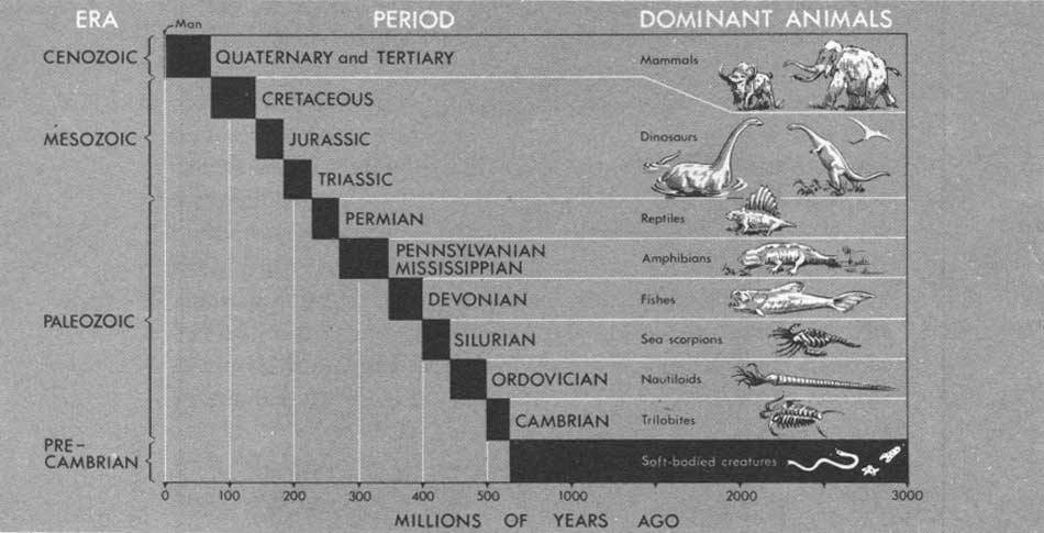
Geologists rarely think in terms of years or even hundreds of years; they usually reckon time in millions of years. To make their work easier, they have divided time into eras, and the eras into periods. Geologists tell us into which eras and periods the rocks belong, usually starting with the oldest and working up to modern times, as in other history books. If you will refer to figure 8 on geologic time divisions, as you read, the descriptions of the rocks will be easy to follow and understand.
|
| Figure 8. Division of geologic time. (click on image for an enlargement in a new window) |
How do geologists know how old different rocks are, or how old the earth is? Until recently, they had to guess, basing their guesses on physical and biological evidence. Geologists know roughly how long it takes for layers of sediments to be laid down. Remains of animals and plants are found at many levels, and study of these fossils can be correlated with the evidence of the rocks themselves. Such dating, however, only establishes the sequence of events; it does not tell how old the earth's rocks actually are.
In the present century a fairly reliable method of age determination has been developed. This method depends on measurements of radioactive minerals in rocks. The atoms which compose uranium, thorium, and other radioactive minerals decay or break up into smaller atoms at a regular rate, and gradually end up as atoms of lead. As the years go by, a rock that contains uranium will have less uranium and more lead in it. By comparing the amounts of lead and uranium, scientists can tell how old the rock is. Use of the radioactive method of dating has shown that the earth is more than 3 billion years old.
In using the table of geologic time, one must remember that these divisions and subdivisions are more or less arbitrary. We use them for convenience in dealing with such long periods of time. The divisions are based on the time estimated for accumulation of sediments and the building of mountains. The passage of time from one period to another was very long, and the changes which developed in the earth's surface were very gradual and overlapped from one period to another.
Ground water is the water stored in the rocks under the surface of the earth. If geologists know the kind of rock in a given area, they can usually tell approximately how much water the rocks are likely to yield. For this reason, all the rocks underlying the area have been carefully listed and described.
The person willing to leave the main roads may see all these rocks a short distance from El Morro.
| <<< Previous | <<< Contents >>> | Next >>> |
wsp/1766/sec2.htm
Last Updated: 01-Mar-2005