|
Gulf Islands National Seashore Florida-Mississippi |
|
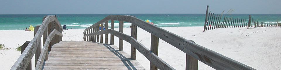 NPS photo | |
Along this Dynamic Seascape, a chain of island strongholds guards against threats from the Gulf of Mexico. Whether facing attacking ships or hurricanes, the military fortifications and barrier islands of Gulf Islands National Seashore have protected these harbors and the mainland through many storms.
Watching the Waters
Among natural beauty and recreational opportunities you will find numerous COASTAL FORTIFICATIONS. The park's collection, like its Third System masonry forts, represents over 200 years of innovation in military design, materials, weapons, and strategy.
Defending the Shore
The THIRD SYSTEM of seacoast defense aimed to fortify major US harbors after the War of 1812. Pensacola Bay was chosen as the site for a navy yard, a depot, mainland and island forts, a naval timber reserve, and more.
The idea was a response to changing warfare technology and strategy—which was also why it was abandoned decades later. Of the nearly 200 forts recommended nationwide, only 42 were built. Today, the park preserves five sites.
FORT BARANCAS
Pensacola, Florida
With Advanced Redoubt and the Spanish Water Battery, Fort Barrancas protected the channel and defended the landward approach to the Pensacola Navy Yard.FORT PICKENS
Santa Rosa Island, Florida
The park's largest fort. Fort Pickens has been partially restored and reveals how its construction has developed over time.FORT McREE
Perdido Key, Florida
Federal forces almost destroyed Confederate-occupied Fort McRee in 1861-62; departing Confederates burned the rest. The fort's remnants are no longer visible.FORT MASSACHUSETTS
Ship Island, Mississippi
Armed secessionists seized Ship Island in 1861; they later exchanged fire with the USS Massachusetts. When the Union recaptured the island, the fort's construction resumed and was completed in 1866.
Islands on the Move
As you explore the barrier islands, can you spot how the landscape changes all around you? Sometimes you will see a gradual edge between two ECOSYSTEMS. Other times, you can step directly from one ecosystem to the next. Each boundary brings a great variety of plants and animals that are adapted to these ever-changing environments. Note how some species establish themselves across habitat boundaries while others truly live on the edge.
Coastal Communities
A range of ecosystems and HABITATS develop where the Gulf's salt water and mainland's fresh water mix. Over 400 fish species, 300 bird species, and a dozen federally listed threatened and endangered species make the park their home. Water makes up over 82 percent of the area the park manages and is a key factor in where these species live.
Gulf
Warm saltwater areas, shallow and deep, house species, big and small.Barrier Island
Water and wind shape and move the islands, changing habitats.Sound
In waterways between the barrier islands and the mainland, saltwater mixes with freshwater.Estuary
Sediment, saltwater tides, and freshwater streams meet and provide a nursery habitat.Bayou
Some species live in slow-moving, lowland streams and freshwater marshes of river watersheds.
Two States, One Park
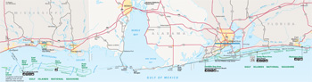 (click for larger map) |
Beaches, bayous, and boating are some of the many things you can experience in this two-state, 160-mile park. Fish, swim, hike, bike, picnic, camp, observe wildlife, discover history, and explore two island wilderness areas. The park's staff, website, and newspaper The Island Breeze can help plan your visit.
From Mississippi to Florida
MISSISSIPPI AREAS The visitor center has information, exhibits, a bookstore, maps, and films. Closed Thanksgiving, December 25, and January 1. The campground (open year-round) has electricity, water hook-ups, a dump station, a group tent area, a boat launch (fee), and pavilions. Reserve sites at www.recreation.gov. Hiking trails are self-guiding. A saltwater fishing license is required for all areas. The Davis Bayou area has a fishing pier. Commercial fishing is prohibited in park waters. Visit the park website for hours and programs.
West Ship Island (Fort Massachusetts) Know what to expect! An unshaded, 0.3-mile boardwalk leads to a swim beach, pavilions, restrooms, showers, and snack bar. Facilities are open mid-March through October. Free tours and exhibits are available seasonally. Tours of the fort are not wheelchair-accessible. Take a passenger ferry (fee) from Gulfport or Biloxi from mid-March through October, or dock your boat near the fort during daylight hours only year-round.
Cat, East Ship, Petit Bois, West Petit Bois, and Horn islands (no facilities) are accessed only by private boat. Use your boat or hire a licensed operator from a list available at the visitor center or our website. Petit Bois and Horn islands are designated wilderness areas—lands untrammeled by humans, undeveloped, and retaining a primeval character with only an impermanent human presence. They are protected to preserve their natural conditions and offer opportunities for solitude or primitive, unconfined recreation.
Backcountry camping is allowed on East Ship, Horn, Petit Bois, and West Petit Bois islands. A permit is required for groups of 10 or more on Horn and Petit Bois islands only. Camping on Cat Island is allowed only on park land. Camping on West Ship Island is prohibited. Bring all your food and drinking water. Groups of 10 or more must get a permit. • Boaters follow NOAA charts 11372, 11373, and 11374.
FLORIDA AREAS The Fort Pickens Discovery Center and the Fort Barrancas Visitor Center have exhibits, films, and bookstores. Visit the park website for operating hours.
A seasonal ferry service (fee) between downtown Pensacola, Pensacola Beach, and Fort Pickens is available March through October. Visit the park website for programs, hours, and guided tours. Entrance fees apply at Fort Pickens, Fort Barrancas, Okaloosa, Opal Beach, and Perdido Key, or show a valid National Parks or Federal Recreational Lands pass. • Hike self-guiding trails at Fort Pickens, Fort Barrancas, Perdido Key, and Naval Live Oaks. • Fish from Fort Pickens' pier without a license; otherwise, state fishing licensing and regulations apply. • Camping reservations are recommended at www.recreation.gov. • Some pavilions can be reserved. The Naval Live Oaks Youth Camping Pavilion is for organized groups only. • Boaters follow NOAA charts 11378, 11383, and 11384.
ENJOY A SAFE VISIT Never swim alone. Beware of rip currents, barnacle-covered rocks, sharks, jellyfish, and stingrays. • Watch for weather extremes, sudden storms, and changing surf conditions. Do not stand on piers, beaches, or fortifications during thunderstorms. • Use caution while exploring forts and batteries. Carry a flashlight for dark passageways. • Some areas and forts close for your safety or wildlife nesting. Avoid walking on dunes and vegetation; obey closure signs. • State boating and fishing regulations apply. Do not fish or boat in swim beach areas. • Glass is prohibited on beaches. • Wear protective clothing. Drink plenty of fluids. Use sunscreen. • Practice "Leave No Trace" principles. • Motor vehicles must stay on paved roads. • Metal detectors and spearfishing are prohibited. • Dogs are prohibited on all Mississippi islands and Florida beaches. • Do not feed or disturb wildlife. • Federal law protects all wildlife, plants, and historic objects. • For all park regulations, including firearms, check our website. • We strive to make our facilities, services, and programs accessible to all. Call or check our website.
Emergencies call 911
Source: NPS Brochure (2018)
|
Establishment
Gulf Islands National Seashore — January 8, 1971 |
For More Information Please Visit The  OFFICIAL NPS WEBSITE |
Documents
A Neogene and Quaternary Geology of a Stratigraphic Test Hole on Horn Island, Mississippi Sound USGS Open-File Report 1996-0020 (Gregory S. Gohn, G. Lynn Brewster-Wingard, Thomas M. Cronin, Lucy E. Edwards, Thomas G. Gibson, Meyer Rubin and Debra A. Willard, 1996)
A Report for (the Proposed) Gulf Islands National Seashore (January 1968)
A Summary of Biological Inventory Data Collected at Gulf Islands National Seashore: Vertebrate and Vascular Plant Inventories NPS Natural Resource Technical Report NPS/GULN/NRTR—2010/398 (November 2010)
Acoustic Monitoring Report: Gulf Islands National Seashore NPS Natural Resource Technical Report NPS/NRSS/NRTR—2014/835 (Cecilia L. White, January 2014)
An Archeological Overview and Assessment of Gulf Islands National Seashore (Susan Hammersten, ed., March 1989)
Black Powder Manual, Gulf Island National Park (1984)
Coastal Hazards & Climate Change Asset Vulnerability Assessment Protocol for Gulf Islands National Seashore NPS 635/154054 (K. Peek, B. Tormey, H. Thompson, R. Young, S. Norton, R. Scavo, M. Koslow and B. Binns, September 2015)
Coastal Topography Change at Gulf Islands National Seashore, Texas: 2018–2021 Data Summary NPS Natural Resource Data Series NPS/GULN/NRDS—2022/1355 (Jeff Bracewell, May 2022)
Coastal Vulnerability Assessment of Gulf Islands National Seashore (GUIS) to Sea-Level Rise USGS Open-File Report 2003-108 (Elizabeth A. Pendleton, Erika S. Hammar-Klose, E. Robert Thieler and S. Jeffress Williams, 2004)
Fort Pickens, 1821-1895: Historic Structure Report — Historical Data Section: (Edwin C. Bearss, 1983)
Fossil chondricthyans and other new paleontological resources reported at Gulf Islands National Seashore, Florida and Mississippi (John M. Clinton, Christy C. Visaggi, Victor J. Perez, Justin S. Tweet and Vincent L. Santucci, extract from Fossil Record 9, New Mexico Museum of Natural History and Science Bulletin, Vol. 94, 2023)
Foundation Document, Gulf Islands National Seashore, Florida-Mississippi (June 2016)
Foundation Document Overview, Gulf Islands National Seashore, Florida-Mississippi (January 2016)
Geologic Resources Inventory Report, Gulf Islands National Seashore NPS Natural Resource Report NPS/NRSS/GRD/NRR-2019/1986 (Courtney A. Schupp, August 2019)
Geomorphic Map of Gulf Islands National Seashore: Florida (2019)
Geomorphic Map of Gulf Islands National Seashore: Mississippi (2019)
Gulf Coast Network Breeding Bird Monitoring Annual Report: 2012 Results from Gulf Islands National Seashore NPS Natural Resource Data Series NPS/GUIS/NRDS-2013/485 (Whitney Granger, May 2013)
Gulf Islands National Seashore Regional Sediment Budget Research and Data Needs: Workshop Series Summary U.S. Geological Survey Open-File Report 2022-1087 (Erin Seekamp, James Flocks, Courtney Hotchkiss, Linda York and Kelly Irick, 2023)
Gulf Islands National Seashore: The Park in Pictures (Edward Kanze, 2010, ©Eastern National
Historic Resource Study: Ship Island, Harrison County, Mississippi, Gulf Island National Seashore, Florida/Mississippi (Edwin C. Bearss, July 1984)
Historic Structure Report — Administrative and Historical Data Sections: Fort on Ship Island (Fort Massachusetts) 1857-1935, Gulf Islands National Seashore, Mississippi (Edwin C. Bearss, January 1984)
Historic Structure Report and Historic Resource Study: Fort Barrancas Gulf Islands National Seashore (Edwin C. Bearss, September 1983)
Historic Structure Report and Resource Study: Pensacola Harbor Defense Project (Edwin C. Bearss, March 1982)
Historic Structure Report — Architectural Data Section: Advanced Redoubt of Fort Barrancas, Gulf Islands National Seashore, Pensacola, Florida (Frederick C. Gjessing and John C. Garner, Jr., January 1975)
Historic Structure Report: Battery 234 CRF/BCS Tower, Pensacola Bay, Florida, Gulf Islands National Seashore (Wiss, Janney, Elstner Associates, Inc., May 2015)
Historic Structure Report: Battery Cullum-Sevier, Gulf Islands National Seashore (Panamerican Consultants, Inc. and Wiss, Janney, Elstner Associates, Inc., December 2018)
Historic Structure Report: Battery Langdon, Pensacola Bay, Florida, Gulf Islands National Seashore (Wiss, Janney, Elstner Associates, Inc., December 2015)
Historic Structure Report — Historical Data Section: Fort Pickens 1821-1895, Gulf Islands National Seashore, Florida-Mississippi (Edwin C. Bearss, February 1983)
History of Ship Island (Ann Christensen, 1973, revised 1974)
Interpretive Prospectus, Gulf Islands National Seashore (L. Clifford Soubier, February 1979)
Long-Range Interpretive Plan, Gulf Islands National Seashore - Florida District (1996)
Masonry Forts of the National Park Service: Special History Study (F. Ross Holland, Jr. and Russell Jones, August 1973)
Military Life in Pensacola in the 1930s and '40s: The Fort Barrancas Oral History Project (David P. Ogden, December 2, 1987)
Monitoring Amphibians in Gulf Coast Network Parks, Data Quality Standards NPS Natural Resource Report NPS/GULN/NRR-2018/1745 (Jane E. Carlson and Whitney Granger, September 2018)
Monitoring Coastal Topography at Gulf Coast Network Parks: Protocol Implementation Plan NPS Natural Resource Report NPS/GULN/NRR-2017/1522 (Jeff Bracewell, September 2017)
Monitoring Breeding Landbirds in National Parks of the Gulf Coast Network: Data Quality Standards NPS Natural Resource Report NPS/GULN/NRR-2018/1767 (Whitney Granger and Jane E. Carlson, September 2018)
Monitoring Breeding Landbirds in National Parks of the Gulf Coast Network: Protocol Narrative NPS Natural Resource Report NPS/GULN/NRR-2018/1765 (Martha Segura, Jane E. Carlson Whitney Granger, William Finney and Jeff Bracewell, Septembe 2018)
Monitoring Seagrass in National Parks of the Gulf Coast Network NPS Natural Resource Report NPS/GULN/NRR-2019/1973 (Joe Meiman and Martha Segura, August 2019)
Monitoring Shoreline Position at Gulf Coast Network Parks: Data Quality Standards NPS Natural Resource Report NPS/GULN/NRR-2017/1502 (Jeff Bracewell, August 2017)
Monitoring Shoreline Position at Gulf Coast Network Parks: Protocol Implementation Plan NPS Natural Resource Report NPS/GULN/NRR-2017/1501 (Jeff Bracewell, August 2017)
Monitoring Terrestrial Vegetation in Gulf Coast Network Parks: Protocol Implementation Plan NPS Natural Resource Report NPS/GULN/NRR-2018/1746 (J.c. Carlson, J. Bracewell, W. Granger and M. Segura, September 2018)
Mounting of Historic Ordnance at Fort Pickens and Fort Barrancas, Gulf Islands National Seashore (Jeffrey L. Parsons, November 19, 1993)
National Register of Historic Places Nomination Forms
Big Heart West (Norma Harris, June 1997)
Butcherpen Mound (Norma Harris, April 1997)
Bateria de San Antonio (Fort Barrancas) (Blanche Higgins Schroer, Frank B. Sarles, Jr. and Horace J. Sheely, Jr., 1958, 1963, August 6, 1975)
First American Road in Florida (Norma Harris and Judith A. Bense, April 1997)
Fort Massachusetts (Dawn /Maddox, March 25, 1971)
Fort Pickens (Randy F. Nimnicht, March 10, 1971)
French Warehouse Site (Susan Hammersten, c1991)
Ft. Barrancas Historical District (Anne Castellina-Dudley, 1978)
Naval Live Oaks Cemetery (Norma Harris, April 1997)
Naval Live Oaks Reservation (Norma Harris and Judith A. Bense, April 1997)
Pensacola Harbor Defense Project (Deborah Slaton, Liz Sargent, Tim Penich and Andi Mele, August 26, 2016)
Perdido Key Historic District (Foster's Bank/Fort McRee) (Anne Castellina-Dudley, February 14, 1978)
Prehistoric and Historic Archeological Properties of the Naval Live Oaks Reservation, Gulf Breeze, Florida (Norma Harris, June 1997)
Third Gulf Breeze (Norma Harris, April 1997)
Natural Resource Condition Assessment for Gulf Island National Seashore NPS Natural Resource Report NPS/GUIS/NRR-2016/1135 (Joanna Hatt, Luke Worsham, Gary Sundin, Michael T. Mengak, Gary Grossman, Nathan P. Nibbelink, February 2016)
Notes on the Preservation of the 15 Inch Rodman Gun, Top Carriage, and Chasis, Ship Island, Gulf Islands (Miss.) National Seashore (John J. Dugan and William K. Kay, July 8, 1980)
Paleontological Resource Inventory (Public Version), Gulf Islands National Seashore NPS Natural Resource Report NPS/GUIS/NRR-2023/2525 (John M. Clinton, Christy C. Visaggi, Justin S. Tweet, Vincent L, Santucci and Kelly Irick, June 2023)
Park Newspaper (Gulf Islands Guide/The Island Breeze): 2008 • 2010 • 2014 • 2017 • 2018 • 2019
Preliminary Report of Historic Sites at Pensacola, Florida (Herbert E. Kahler and C.E. Vinten, January 1938)
Report of Specific Area Study, Gulf Islands, Alabama and Mississippi (February 1962)
Report on Investigation of Ship Island and Fort Massachusetts Near Gulfport, Mississippi (Nelson Royal, Jr., June 28, 1937)
Reptile & Amphibian Monitoring at the Naval Live Oaks Beaver Pond, Gulf Islands National Seashore: Data Summary, Monitoring Year 2012 NPS Natural Resource Data Series NPS/GULN/NRDS-2013/554 (Robert L. Woodman, September 2013)
Research Perspectives — 1982, Gulf Islands National Seashore Coastal Field Research Laboratory NSTL Station, Mississippi 39529 (Stephen V. Shabica, April 22, 1982)
Restoration Feasibility Report: Santa Rosa Life Saving Station and Coast Guard Garage, Gulf Islands National Seashore (Joseph K. Oppermann-Architect, April 2022, Ch. 1 & 2 Preview Draft)
Seagrass Communities of the Gulf Coast of Florida: Status and Ecology (Clinton J. Dawes, Ronald C. Phillips and Gerold Morrison, August 2004)
Shoreline Change at Gulf Islands National Seashore, Florida and Mississippi: 2018-2021 Data Summary NPS Natural Resource Data Series NPS/GULN/NRDS-2022/1348 (Jeff Bracewell, March 2022)
Shoreline Change at Gulf Islands National Seashore, Florida and Mississippi: 2018-2022 Data Summary NPS Natural Resource Data Series NPS/GULN/NRDS-2022/ (Jeff Bracewell, December 2022)
Special History Study: A History of the Naval Live Oak Reservation Program, 1794-1880: A Forgotten Chapter in the History of American Conservation, Gulf Island National Seashore, Florida/Mississippi (Charles W. Snell, September 1983)
Statement for Management, Gulf Islands National Seashore: 1991 (1991)
Statement for Management, Gulf Islands National Seashore: 1995 (1995)
Superintendent's Annual Report: 1991 • October 1995-September 1996 • October 1996-September 1997
Tales of Ship Island: The Skrmetta Family (Mike Hobbs, Robert Spilsbury and Kim Bennett, September 26, 1999)
The 13th Coast Artillery at Pensacola: The Fort Barrancas Oral History Project (David P. Ogden, 1987)
The ponds and lagoons of horn and Petit Bois Islands, Mississippi, Gulf Island National Seashore: their physical size, literature review and recommendations for future research NPS Research/Resources Management Report SER-60 (Stephen Shabica and Janet Watkins, January 1982)
The Road Inventory of Gulf Islands National Seashore (Federal Highway Administration, June 1998)
The Ship Island Quarantine Station: The Nation's First (Kimberly Bennett, 2000)
Vegetation Monitoring Before and After Beach Renourishment on Perdido Key: A Proposal to the National Park Service (David J. Gibson, June 28, 1989)
Wilderness Study of Gulf Islands National Seashore (W. Drew Chick, Jr., July 1971)
Wildlife Report: Proposed Ship Island National Monument, Mississippi (James O. Stevenson, undated)
Gulf Islands National Seashore: The Treasure of the Gulf Coast
guis/index.htm
Last Updated: 01-Jan-2025