|
Hubbell Trading Post
Cultural Landscape Report |

|
EXISTING CONDITIONS
Hubbell Trading Post National Historic Site consists of the aggregation of historic buildings, structures, and agricultural fields that were designed and constructed by the J.L. Hubbell family and the local Navajo community. The property was added to the Historic Sites Register in 1960 and administratively listed as a National Historic Landmark with passage of the 1966 National Historic Preservation Act. National Park Service administration began in 1967.
The existing park boundaries include the original 160 acres that were claimed by homestead and eventually granted to J.L. Hubbell in 1906, however it should be noted that a substantial amount of additional acreage located outside of the official homestead boundary was actively utilized by the Hubbell family and contributed to the development and operation of the trading post operation. Key use areas identified outside of the National Park Service boundaries include the irrigation reservoir, Hubbell Hill, Ganado Lake and Dam, and the main irrigation canal that served the Hubbell agricultural fields. Because of the significance of these areas with regard to the overall spatial organization and daily operation of the historic trading post they are addressed in this study.
|
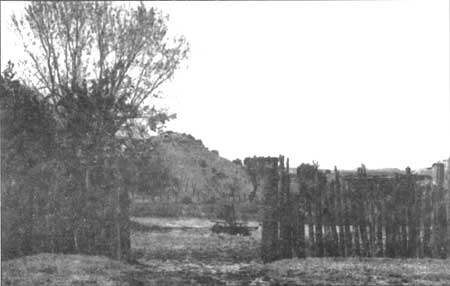
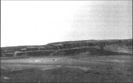
| Figure 44. View from the shed area toward Hubbell Hill, 1993. |
SPATIAL ORGANIZATION AND EXISTING PATTERNS OF LAND USE
As mentioned above, the majority of the Hubbell Trading Post cultural landscape is owned and managed by the National Park Service while three additional areas lie within the Navajo Reservation lands. The overall spatial organization of the landscape is much the same as it was historically with the exception of the addition of facilities for visitor use and park staff.
Seven character areas have been identified within the Hubbell landscape. These areas were identified during analysis of historic land use activities and provide a manageable means of documenting, describing, and organizing management and treatment recommendations for the myriad character-defining features that contribute to the integrity of the trading post landscape. The seven areas are comprised of the agricultural fields, trading post and residential compound, barn lot with associated sheds and corrals, specialty garden areas including the vegetable and flower gardens, school and chapter house site, Hubbell Hill, and the irrigation reservoir and main canal including Ganado Lake and Dam.
The majority of these areas were spatially contiguous and visually connected due to the open nature of the landscape in and around Ganado. The exception to this was the Ganado dam and portions of the main irrigation canal located approximately 2.5 miles from the trading post site. These conditions are very much the same today. The various activities that were performed in each area during the different periods of site occupation and use have changed somewhat, however this will be discussed in the section on land use.
The historic terraces and irrigation features are still readily discerned by the astute visitor in looking south across the abandoned agricultural fields that border the park's entry road and continue south and west behind the historic trading post corrals and sheep pens. Of the five fields that once comprised the Hubbell fields one has been modified to provide a residential housing complex for park employees. The remaining four fields are abandoned but continue to reflect their historic land use patterns although they are slowly undergoing successional vegetation change as they fill in with the shrubby growth of sage, Russian thistle, and chamisa. The sewage lagoon that was constructed in the 1960's along the northern edge of one of the agricultural fields is no longer functional as a lagoon but serves as a staging area or bone yard for the park maintenance division. The earthen embankment provides a visual screen for the assortment of materials stockpiled within although other boneyard areas within the park are openly visible.
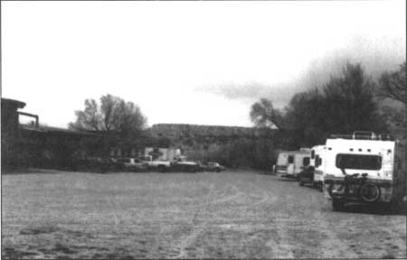
The historic trading post continues to operate and serve the community as well as an increasing number of park visitors. As evidenced in the following photographs the large parking area adjacent to the trading post remains as informal as it was historically (figures 45 and 46). The warehouse adjoining the trading post continues to be utilized for storage purposes by the trader and the addition to the south provides the park with curatorial storage and staff office space.
|
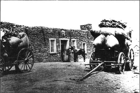
| Figure 45. Loaded freight wagons east of Trading Post, around 1906. (RP 54). |
|
| Figure 46. Vehicle parking east of Trading Post, 1933. |
The residential compound area is used for park staff housing, VIP lodging, and visitor interpretation. Visitors are free to explore the compound and are provided access to the Hubbell residence through ranger led open house tours. The guest hogan has been rehabilitated to provide on site lodging for VIP's, and the manager's residence is occupied by a park employee. The residential compound continues to be definable as a vernacular working yard and retains a variety of features that are reflective of the historic land use patterns and the spatial organization of the area. These features include a privy structure now used as the park's fire hose house, an active chicken house and pen, and a clothes line.
The historic barn is utilized by the park for a variety of purposes including storage of large curatorial objects, feed and tack storage and shelter for the park's three resident horses and one mule. The surrounding barn lot with its wagon sheds, corrals and pens also contains feed and water troughs for the park's horse. In addition to providing an enclosure for the horse the area is used for storage and display of large curatorial objects such as wagons, manure spreaders, and horse-drawn hay balers.
Remnants of the Hubbell family's specialty gardens areas used for growing vegetables and flowers remain evident throughout the landscape. One area that lies adjacent to the Hubbell residence is annually cultivated with a variety of vegetables by the park staff. The Hubbell family's primary vegetable garden area remains surrounded by a fenced enclosure however it is rapidly filling with young seedlings and sprouts from the wild plums that were once under controlled cultivation in the vicinity. Surviving historic plant specimens including roses, lilacs, and yuccas belie the locations of flower beds and decorative plantings throughout the residential compound and areas adjacent to the barn lot area.
The old school house/chapter house functions as the park's administrative office and visitor contact station/exhibit hall. The area surrounding the historic chapter house includes public restroom facilities, two picnic areas, a small parking area with spaces reserved for the disabled and park staff, and the park library located in the historic root cellar.
For the purposes of this study, the existing conditions of the remaining areas which are outside of the National Park Service boundary continue to be significant to the overall landscape with regard to spatial organization and land use patterns. Hubbell Hill remains undeveloped with the exception of the Hubbell family gravesites along the top eastern edge of the ridge. The irrigation reservoir constructed as a holding area for supplying the Hubbell fields lies abandoned just outside of the park boundary to the south. The main canal of the irrigation ditch and its numerous features including sluice gates, reverse siphons, and aqueducts are in various states of disrepair both above and below the Hubbell reservoir. The main canal serves to connect the Hubbell reservoir with Ganado Lake located approximately 2.5 miles northeast of the trading post. Ganado Lake served as the water source for the Hubbell irrigation system.
In 1990 the lake was drained for the second time to facilitate the replacement of the historic dam which had been declared a safety hazard by the Bureau of Reclamation. Construction on the new dam was initiated during the summer of 1994 and the new structure was completed in late September of 1995. It is estimated that the lake will need approximately three to five years to fill to a point where adequate water can be drawn off for irrigation purposes.
CIRCULATION
The circulation system associated with the present day Hubbell cultural landscape is made up of primary and secondary roads, paths and trails, walkways, and parking areas. Arizona State Highway 264, a well maintained paved highway that ranges from two to three lanes serves as the primary road that accesses the park. The entry road connects with Highway 264 and is approximately four tenths (.4) mile in length. This entry road is paved with asphalt for the first 1200', however once visitors cross the wooden plank surfaced bridge they experience the crunching sounds and slow speeds of the gravel surfaced road that leads the remainder of the way to the trading post and the visitor center.
Two secondary service roads branch off of the entry road and lead to the park housing and maintenance areas. Both of these roads are surfaced with asphalt, have cattle guards and are not intended for visitor use. Another secondary park service road branches off of the entry road and follows the perimeter of the park along the boundary fence. Sections of this road follow the alignment of the primary historic entry road to the trading post while other sections follow the historic field road alignments. The road continues to be maintained as a bladed dirt service road kept accessible for park maintenance vehicles or pedestrian use by park staff and visitors.
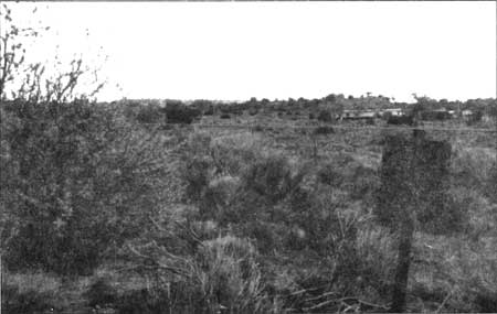
The road that once served as the primary route to the trading post complex now lies abandoned from the trading post north to the highway and serves as a service road and pedestrian lane as it runs to the south. The surface of the northern end of this road is comprised of decomposed asphalt that is naturally revegetating with native species such as rabbitbrush (Chrysothamnus nauseosus), snakeweed (Gutierrezia sarothrae), four-wing salt bush (Atriplex canescens),and shade scale (Atriplex confertifolia) (figure 47). Remnants of the old highway bridge that carried the road across the Pueblo Colorado Wash consist of a few timber pilings. The road was abandoned in 1967 and the bridge was demolished in 1968. Just south of the barn the road narrows down to a single lane that runs between two large terraced fields and a row of aged cottonwood trees. Vehicular use of this road is limited to park maintenance staff, however both park staff and visitors alike use the lane for walking and hiking. Although the road is criss-crossed with tightly strung barbed wire fences, numerous stiles are available for the use of pedestrians.
|
| Figure 47. Section of old, abandoned highway on north side of Pueblo Colorado Wash, 1993. |
While numerous informal paths continue to be utilized throughout the Hubbell landscape, the primary path runs alongside the entry road and connects the staff housing area with the administrative office and trading post. The path is visually inconspicuous as it is a single width trace of trodden vegetation and compacted soil. Another path that is daily used by staff and visitors alike is the stepping stone path that runs north - south between the trading post building and the Hubbell residence. The other paths and trails found in the park include a random network of desire lines and undeliniated pedestrian use areas.
Flagstone surfaced walks of reddish tan sandstone are located around the old chapter house that now serves as the park's Administrative Office/Visitor Center and along the north and west sides of the Hubbell residence connecting the family house with the guest hogan and the manager's residence.
Vehicular parking is provided in two separate areas. A small parking area providing reserved spaces for disabled access, park staff, and authorized vehicles is located adjacent to the Administrative Office/Visitor Center. The lot is surfaced with compacted gravel and peeled logs are used as wheel stops for the individual parking spaces. The larger parking lot is also surfaced with compacted gravel and it remains informal with no officially delineated parking spaces. Its informal character remains highly compatible with the historic landscape and allows flexibility for visitors parking oversize recreational vehicles.
VEGETATION
Existing vegetation patterns within the old field areas, along the Pueblo Colorado Wash and its secondary drainages, and throughout the various building and development complexes reflect the historic land use activities that occurred throughout the developmental history of the Hubbell Trading Post landscape. These patterns were documented during field investigations and are described below.
Through disuse the agricultural fields are gradually infilling with both native and exotic invasive vegetation including rabbitbrush (Chrysothamnus nauseosus), snakeweed (Gutierrezia sarothrae), four-wing salt bush (Atriplex canescens), shade scale (Atriplex confertifolia), Russian thistle or tumbleweed (Salsola iberica), tumble mustard (Sisymbrium altissimum), ragweed (Ambrosia sp.), Siberian elm (Ulmus pumila), alfalfa (Medicago sativa), cocklebur (Xanthium strumarium), and field bindweed (Convolvulus arvensis). Along many of the irrigation system's lateral ditch lines there remain remnants of the fruit and shade trees planted by the Hubbell family and the field hands working for them. The lateral ditch (lateral A) that runs just west of the housing area has a few of the aging cottonwoods (Populus sp.) remaining although the majority of them were recently removed by the park after being determined health and safety hazards. The remnant stumps reveal the historic spacing and layout for the planted trees along this lateral. Cottonwoods also define the northern edge of the Hubbells easternmost agricultural field. The remnants of this row of large cottonwoods are located along the south side of the park's entrance road. The majority of these trees were determined to be diseased and dying and were subsequently removed by the NPS in the early 1990's. The park has recently transplanted numerous saplings from the large silver-leaved poplar (Populus alba) that is on the site of the visitor center building however the extremely invasive trees make them a highly undesirable choice.
The ditch identified as lateral B runs in a north south direction and lies just west of the arroyo near the housing area. This ditch line was also planted with a combination of cottonwoods and fruit trees. A few large aged cottonwoods (Populus sp.) survive along with a couple of apricot (Prunus sp.) and peach (Prunus sp.) trees that are in very poor condition. The northern boundary of this field has a row of 10 elm (Ulmus pumila) trees and two surviving historic walnut (Juglans arizonica) trees. The southern boundary of the field is delineated by a ditch line and the earthen berm of the irrigation reservoir. Several cultivated fruit and nut trees remain along this southern ditch line and they include two apple (Malus sylvestris) trees, five junipers (Juniperus monosperma), and a single black mulberry (Morus negra) although historically there were many more.
Immediately west of the dirt wagon lane and south of the Hubbell barn is another lateral irrigation ditch which has been identified for documentation purposes as lateral C. There are several large cottonwoods in various states of decline located along this lateral. Several of the large trees have died as a result of age and limited water while one of the largest of these cottonwoods has been killed by lightning. There are also a few "volunteer" elms (Ulmus pumila) and a couple of historic apple (Malus sylvestris) trees continue to survive as a result of recent watering by the park maintenance staff. A cross ditch intersects with lateral C and runs in a westerly direction immediately adjacent from the northern edge of the earthen reservoir. Just west of the intersection of these two ditches are two surviving historic apple (Malus sylvestris) trees that park maintenance is actively watering to preserve.
One lone cottonwood in poor condition marks the northern most section of lateral C and is located immediately west of the residential and trading post complex. Based on the presence of down and dead cottonwood trees along this same orientation it may be surmised that the line was once defined by the presence of these trees.
Of particular research interest with regard to historic vegetation patterns is lateral D in that numerous dead historic apple trees were noted and documented at a regular spacing of approximately 20 feet on center. The historic trees were identified by the skeletal remains of their dried trunks, roots, and branching patterns. The remnants of approximately 12 trees were documented along this lateral ditch line although historically there were many more. In contrast to the planted apple trees along lateral D are the elm trees found along the next lateral to the west - lateral E. While some of the elms appear to have been intentionally planted along the irrigation ditch numerous others have "volunteered" either through sucker sprouts or seed distribution.
Dividing the Hubbell agricultural fields there is an old wagon lane that runs south from the trading post complex to the gravel road just off the park boundary. There is a dense growth of rabbitbrush (Chrysothamnus nauseosus), snakeweed (Gutierrezia sarothrae), four-wing salt bush (Atriplex canescens), shade scale (Atriplex confertifolia), Russian thistle or tumbleweed (Salsola iberica), tumble mustard (Sisymbrium altissimum), and ragweed (Ambrosia sp.) along either side of this lane continuing up to the fenced edges of the fields. Photographs reveal that historically this area was relatively clear of shrubby vegetative growth, most likely as a result of both trampling (vehicular, pedestrian, and livestock) and intensive grazing. While it is not representative of the historic scene, the dense shrubby growth now provides habitat for numerous wildlife species including desert cottontail, prairie dog, and various types of birds.
The most dramatic change that has occurred with regard to vegetation patterns within the Hubbell landscape occurs in the area of the natural drainages and the Pueblo Colorado Wash. As mentioned in the preceding discussion above, several cottonwoods were historically planted along the irrigation ditches that bordered the northern edge of the easternmost field and along the eastern side of the arroyo immediately west of the existing park staff housing area. A similar row of eight very large historic cottonwoods were noted running east west along the upper terrace of Pueblo Colorado Wash immediately west of the Hubbell residence and trading post complex. The condition of these historic trees ranges from fair to poor.
Comparative analysis of historic photographs with existing conditions reveal that from the top of the natural terraces down into the main drainages and the Pueblo Colorado Wash there has been a substantial increase in vegetation density (figures 48 and 49). While some of the changes are a result of natural succession with native plant species following the removal of grazing activities the majority represent the invasive actions of exotic plant species introduced through a variety of Federal programs during the second quarter of the 20th century.
The vegetation found within the arroyo west of the park housing area includes primarily native plant species including two varieties of willow (Salix sp. and Salix sp.) and several native herbaceous species such as willow smartweed (Polygonum lapathifolium), sedge (Scirpus americanus), mallow (Sphaeralcea sp.), and horsetail (Equisetum arvense). This is in contrast to the numerous exotic invasive species that have established in and along the Pueblo Colorado Wash. The main wash is densely vegetated with visually dominant exotic plant species including Russian olive (Eleagnus angustifolia), saltcedar (Tamarix chinensis), along with a variety of both native and exotic shrub and herbaceous species. The Russian olive and salt cedar are now fairly typical throughout the Southwest following their introduction during the 1930's and 1940's for erosion control efforts.
The existing vegetation found within the developed areas associated with the trading post is varied and contains numerous relict historic plant species that were introduced to the site either by the Hubbell family or during the time of their operation and management of the landscape. The area surrounding the historic school house/chapter house complex is bordered along its southern and western boundaries by a row of 12 elm (Ulmus pumila), however 5 of the elms were recently removed at ground level following a hazardous tree assessment conducted by the park. Several of the stumps have sprouted vigorous young saplings that exceed 15' in height after only a couple of years growth. Planted as an understory to the alignment of elm trees along the southern boundary there are 6 historic golden currant (Ribes aureum) shrubs in good condition.
A few feet west of the southwestern corner of the historic school house building there is a very large silver-leaved poplar (Populus alba). This tree is in fair condition with several large dead or dying branches. Throughout the school house "yard" area there are numerous seedlings, saplings, and sucker plants from both of the exotic invasive trees historically planted within this area. It should be noted that seedlings and saplings from this single specimen of the silver-leaved poplar and the siberian elms are found spreading into other areas of the Hubbell landscape.
In addition to the trees and their numerous sprouts and seedlings there is a variety of herbaceous plant material comprising the ground layer. These plants include field bindweed (Convolvulus arvensis), rayless goldenrod (Chrysothamnus nauseosus var. graveolens), hairy goldenaster (Heterotheca villosa), prickly pear (Opuntia macrocentra), mallow (Sphaeralcea sp.), and white aster (Leucelene ericoides). Many of these plants are also found across the parking lot scattered throughout the northern end of the enclosed yard in front of the Hubbell residence. It should be noted that these plants are characteristic of the mix of natives and exotics that are found throughout the Southwest.
|
| Figure 48. Pre-1913 Hubbell landscape showing sparse vegetative cover along Pueblo Colorado Wash. (HUTR 4398). |
|
| Figure 49. Hubbell landscape showing invasive vegetation along Pueblo Colorado Wash, 1993. |
There is a substantial area of the yard that is covered by lawn although according to both oral histories and historic photographs the lawn area was limited to a single bermed strip just north of the walk that runs along the front of the house. Immediately north of the earthen berm is a large bed of historic lilac (Syringa vulgaris) shrubs. Around the interior of the stone wall that encloses the yard to the east and north there are dense plantings of broad leaved yucca (Yucca baccata) and Fendler rose (Rosa woodsii var. fendleri). These same historic plants are also found in a circular stone planter located in the center of the yard east of the shade ramada structure. Surrounding the ramada are several historic plums (Prunus gracilis and Prunus reverchonii) and historic silver lace vine (Polygonum aubertii) and Virginia creeper (Parthenocissus quinquifolia) densely covers the structure. Adjacent to the ramada and just south of the guest hogan there is another small mass of plum trees (Prunus gracilis and Prunus reverchonii) that continue to spread along the edge of the old garden area.
Along the front walk of the Hubbell residence an historic log trough is used as a flower planter and nasturtiums and other colorful annual flowers are cultivated by park staff members. Just south of this planter is a low board and chicken wire fence (recently rehabilitated by park staff) and growing along it is the Virginia creeper (Parthenocissus quinquefolia) vine. Lying west of the Hubbell residence and south of the guest hogan is a terraced garden plot that is annually cultivated by park staff and although the crops grown tend to vary from year to year they usually include corn, tomatoes, and squash. In the area of the southeast corner of this garden plot, in the vicinity of the bread oven there is a large mass of iris (Iris germanica). Their origin has not been established although an early NPS employee working at the park noted that they were well established in the late 1960's. [128]
There are several narrow planting beds along the east and north walls of the manager's residence and they contain a variety of both native and exotic annual and perennial flowers planted and maintained by park staff. West of the manager's residence is the chicken house/utility building which has two somewhat picturesque historic juniper trees along its southwest side. Their condition is fair however they do contain some dead and dying branches.
The surrounding barn lot to the south is covered and maintained in low grasses although historically it was simply bare, compacted soils. Other vegetation found in the immediate vicinity includes prickly lettuce (Lactuca serriola), filaree (Erodium cicutarium), common mallow (Malva neglecta), common dandelion (Taraxacum officiinale), pigweed (Amaranthus wrightii), puncture vine (Tribulus terrestris), and clovers (Meliotus alba and M. officinalis). The vegetation around the stone bunkhouse includes a medium sized cottonwood (Populus sp.) on the northeast corner which is in good condition although there are numerous cottonwood saplings and root sprouts surrounding its trunk. On the southeast corner of this building is a multi-trunked plum (Prunus gracilis) also in good condition. Immediately south of this structure is an enclosed garden area that is being infilled by a variety of weeds and numerous wild plum (Prunus gracilis and Prunus reverchonii) saplings and seedlings. Several of these trees are also found along the post and wire fence on the east side of the garden plot. There is also a dense covering of Virginia creeper (Parthenocissus quinquefolia) and grape (Vitis sp.) along the fence.
Vegetation found within the vicinity of the park housing area is reflective of the new development that has been occurring there. A row of Russian olive (Eleagnus angustifolia) has been planted by the NPS along the eastern boundary fence line adjacent to the service road that leads into the maintenance yard. A variety of plant materials have been introduced to the site in the vicinity of the trailer park and include numerous ornamental and exotic species such as crab apple (Malus soulardii) and lilac (Syringa vulgaris). The newly developed housing area includes small lawn areas adjacent to each residence as well as some ornamental vegetation such as serviceberry (Amelanchier sp.), New Mexican privet (Foresteria neomexicana), Jackman potentilla (Potentilla fruticosa jackmanii) and wild rose (Rosa woodsii).
STRUCTURES
Within the park boundaries there are 13 historic buildings and numerous historic structures. The buildings include the trading post, Hubbell home, barn, manager's residence, bunkhouse, guest hogan, utility building/chicken house, wareroom extension, sheds, hogan in the lane, school/chapter house, pumphouse/restroom, and root cellar/library. Additional park building numbers have been assigned in the past to features that are referred to as structures in this report and those inconsistencies are identified in the table that follows this discussion.
The majority of the buildings are found within three of the seven character areas identified for this historic landscape while the historic structures are located throughout all of the character areas. The historic structures found within the vernacular landscape include numerous stiles, gates and fences; garden features such as the summerhouse and stone planter bed; irrigation structures including head gates, ditches, siphons, and flumes; irrigation reservoir and sewage lagoon; matanzas; and a tree house. As mentioned above, some of these structures have been assigned park building numbers and while all recorded historic buildings have been included on the List of Classified Structures (LCS) inventory only some of the historic structures are listed.
There have been numerous studies involving the documentation, preservation, interpretation, and management of the buildings and structures that comprise the Hubbell historic site although few of these address these resources as they relate to the site as a whole. [129] The overall approach of the previous historic structures reports and preservation guides has been to retain the site's numerous architectural resources through preservation maintenance actions. The existence of this variety of historic buildings and structures that accurately represent the continuum of use within the Hubbell landscape is essential to maintaining the landscape's special "sense of place" for the visitor and community to experience.
| |
| Hubbell Trading Post | - HB-01 (LCS#12094) |
| Hubbell Home | - HB-02 (LCS#00721) |
| Two-Story Barn | - HB-03 (LCS#00722) |
| Manager's Residence | - HB-04 (LCS#07953) |
| Bunkhouse | - HB-05 (LCS#07954) |
| Guest Hogan | - HB-06 (LCS#07955) |
| Utility/Chickenhouse | - HB-08 (LCS#07956) |
| Wareroom Extension | - HB-09 (LCS#07242) |
| Corrals and Sheds | - HB-10 (LCS#07957) |
| Hogan in the Lane | - HB-11 (LCS#07958) |
| School/Chapter House | - HB-12 (LCS#64935) |
| Pumphouse/Restroom | - HB-13 (LCS#64936) |
| Root Cellar/Library | - HB-16 (LCS#64937) |
| |
| Bread Oven | - HB-07 (LCS#00723) |
| Agricultural Fields | - HB-18 (LCS#64942) |
| Irrigation Headgates and Ditches | - HB-19 (LCS#64940) |
| Gazebo/Summerhouse | - S-02 (LCS#64939) |
| Cactus Planter and Sundial | - S-04 (LCS#64941) |
| Rock Wall | - S-05 (LCS#64944) |
| Stiles | - to be recorded |
| Tree House | - to be recorded |
| Gates and Fences | - to be recorded |
| Matanzas | - to be recorded |
| Irrigation Reservoir | - to be recorded |
| Sewage Lagoon | - to be recorded |
| Brick BBQ | - to be recorded |
| Lighting Fixture | - to be recorded |
| Stone Picnic Table | - to be recorded |
| Stone Picnic Benches | - to be recorded |
| Stone Retaining Walls | - to be recorded |
| Privy (firehose house) | - to be recorded |
In addition to the historic buildings and structures found within the Hubbell landscape there are several that have been introduced by the National Park Service and are classified as non-historic. These include the park housing units that consist of one modular home and 10 newly constructed houses. All the existing house trailers are in the process of being removed and will be gone by late summer 1996. The maintenance area for the park consists of 2 sea crates used for equipment storage, a prefabricated Bailey building, and a row of storage shelters. Other buildings include two stone masonry fire hose houses in the vicinity of the trading post and two hose houses in the vicinity of the housing area.
VIEWS AND VISTAS
Due to the open and expansive nature of the landscape there are numerous vantage points that offer views into, within, and beyond the park boundaries. The majority of these views are considered desirable by the park visitor and researcher alike although there are a few undesirable views that likely detract somewhat from the "historic scene".
Unfortunately two of the most undesirable views are experienced as one enters the historic site. Immediately upon turning onto the park's entrance road the visitor's eye is drawn to the park employee housing area to the south and the numerous erosion control gabion structures in Pueblo Colorado Wash to the north. The housing development consists of a trailer park immediately adjacent to the entrance road, a newly constructed housing complex, and a maintenance yard further to the south and east. Views into the housing area are open, unscreened, yet highly characteristic of the reservation. Views across the road towards the rock-filled gabion structures are also unscreened however it should be noted that the recent addition of fill material in and over some of the gabions has allowed native plants to become established and subsequently soften any potential visual impacts. It should also be noted that both the housing area and the erosion control features are essential to the operation of the park and the preservation of its resources. While it is unfortunate that they are located along the entrance road they are in fact distanced from the primary core area of the historic landscape. Once the visitor crosses the wood plank bridge and the road changes from asphalt to gravel the views to and beyond the trading post, Hubbell residence, and farm lands are spectacular and a true "sense of place" can be developed. Additional discussions regarding these two particular views are included in the Treatment Recommendations and Development section of this report and recommended treatments are provided.
Litton has identified seven different types of landscape views and although they were originally defined with regard to forest landscapes they are also applicable to the Colorado Plateau and the Hubbell landscape. [130] It has been determined that five of the seven types of landscape views are present within the Hubbell landscape. These include the feature landscape, panoramic landscape, focal landscape, detail landscape, and ephemeral landscape. Refer to Appendix 2 for definitions of these various landscapes.
Views toward and into the trading post and residential complex as well as the barn lot and corral area would constitute a feature landscape. Approximately 500' down the entrance road one gets an excellent view to the west of the trading post complex and views to the south across one of the historic agricultural fields. These views seem to enhance the visitor's expectations as they near the core of area of the historic site. From the parking area the visitor is afforded views to the north, south, and west. Looking north from the trading post one sees Hubbell Hill, a prominent rocky hill upon which many of the members of the Hubbell family have been buried. Views south and west of the trading post reveal more of the terraced agricultural fields and the surrounding open landscape.
As one traverses the boundaries of the park, the views within and out of the Hubbell landscape are not restricted except in the immediate area of the densely vegetated Pueblo Colorado Wash. These panoramic views are found to be spectacular on a daily basis but if one is fortunate to catch them when atmospheric conditions are changing such as dawn or dusk or as a thunderhead is approaching, the ephemeral landscape views are simply unsurpassed within the historic landscape.
In addition to the long range or panoramic views there are numerous close range views and photographic opportunities available as one explores the residential compound and bam lot area. These views include the focal and detailed landscape. The focal landscape is experienced as one travels along the long linear roads that are so characteristic of the Hubbell landscape or views along the numerous headgates that follow the alignments of the irrigation laterals. The detail landscape on the other hand is experienced with respect to immediate foreground distances and a pedestrian pace where minor details are noted such as individual plant materials, fencing or gate details, etc.
ARCHEOLOGICAL RESOURCES
Approximately 14 archeological sites have been located and recorded within the existing park boundary. The condition of these sites varies from poor to good with erosion being the most apparent primary threat. Test excavations and a variety of site stabilization techniques have been utilized on several of the sites to either mitigate impacts from development or to slow the processes of erosion. The archeological sites that have been recorded within the park boundaries and range in date from A.D. 0 through the mid twentieth century. Several of the archeological sites located within the boundaries of the park might easily be located by even the novice visitor as a result of the readily visible surface scatter of artifacts and this should be considered by planners prior to accommodating visitor access to these areas.
Erosion is another factor that results in the easy identification and degradation of the park's archeological sites. The site known as the Wide Reed Ruin has structural features that have been exposed through slumping soil action and illegal pothunting activities. The erosion of site HUTR 10 was slowed in 1984 when the site was backfilled and stabilized using a filter fabric material. Areas of the filter fabric covering the site are presently exposed to ultraviolet radiation as the loose sandy soils have been displaced by the winds that buffet the site.
Existing landscape treatment and management actions are a potential concern with regard to the archeological resources associated with the original Leonard trading post complex. The potential impacts of water infiltration as a result of the recent heavy watering activities in and around the ramada structure and front yard area have not been adequately assessed with regard to these significant and potentially informative sub-surface resources.
BOUNDARIES
As mentioned earlier in this report, the park boundaries include the 160 acres that originally comprised the Hubbell homestead claim. Generally speaking, the northern boundary is defined by the Pueblo Colorado Wash and a belt of floodplain vegetation which is predominantly saltcedar (Tamarix chinensis) and Russian olive (Eleagnus angustifolia), The vegetation along the wash tends to block views both into and out of the property and most likely help to diffuse some of the vehicular noise that emanates from Highway 264. West of the trading post complex the northern boundary dips southward and is defined by a wood post and tightly strung eight strand barbed wire fence line that also serves to define the northern edge of the agricultural fields although judging from the existence of water gates on the eroding slopes of this terrace, the fields extended north of this fence line at some earlier date.
The western boundary of the property is also defined by an 8 strand barbed wire and wood post fence. Vegetation along the fence lines consists of chamisa, four-wing saltbush, snakeweed, Russian thistle, etc. A wide natural arroyo also helps to define the western edge of the park property. The southern boundary is defined by a wood post and 8 strand barbed wire fence line with some shrubby growth on either side. As with the western boundary, the southern fence line marks the limit of the agricultural field. The main irrigation canal runs along the southern side of the fence line and an unimproved secondary dirt road is located just south of the canal. The southern boundary takes a jog to the north as it nears the five acre irrigation reservoir and then continues eastward. The wood post and barbed wire fence line continues to define this boundary. Immediately south of the fence line is a small privately owned five acre fallow field and then south of that is the irrigation reservoir. The eastern boundary is located approximately 88 yards west of Highway 264 and like the others is marked by a wood post and 8 strand barbed wire fence line. There are a few pinyon and juniper trees scattered along portions of this fence line in addition to a recently planted row of Russian olive trees.
SMALL SCALE FEATURES
The small scale features that are presently found within the Hubbell landscape are numerous and varied. While some of these features are contemporary, many more date from the site's early history and have been specifically identified and referenced using historical documentation.
Contemporary small scale features include the wrought iron stile used by park staff in the housing area, wooden barrel trash receptacles, rectangular metal trash receptacles and metal barrel receptacles both types of which are painted brown, ceramic tile ash receptacles, directional and interpretive signage, cattle grates, and picnic tables. The majority of these features are included on the existing condition map for the site.
Historic small scale features found within the historic landscape include a sundial and other garden ornamentation, a rough hewn log trough that is used as a flower planter, wagon wheels used as ornamentation by the Hubbell family, and a grinding wheel. Other small scale features introduced to the site by the Hubbell family include large specimens of petrified wood and minerals, a plaster bas relief plaque that hangs over the main entry to the trading post, irregularly shaped and engraved sandstone signage, small stone benches, numerous farm implements, and wooden matanzas (slaughtering rack).
| <<< Previous | <<< Contents >>> | Next >>> |
hutr/clr/clr3.htm
Last Updated: 26-Apr-2004