|
Oregon Caves National Monument and Preserve Oregon |
|
 NPS photo | |
Intimate Adventure Outside Time
Tall trees reach skyward, framing the curves as you climb a road built just to reach these high-elevation caverns. At the end of the climb, breathe in the medley of fragrances exhaled by the ancient forest that blankets the Siskiyou Mountains. Take a stroll. Listen. Follow the burbling sounds of a creek. Discover it tumbling out of the rock. Feel the wet, cold breath of the cave on a hot summer day—both foreboding and beckoning you.
Nearby, notice how the Chateau curls gracefully around the creek and cave entrance, embracing it. The rustic exterior of Port-Orford-cedar bark blends with the surrounding forest. Explore inside the Chateau. Discover the brook that babbles through the dining room. Relax in the lobby's pleasing mix of forest and cave ambience. Sit, relax, mull over all the nearby hiking opportunities. Discover Oregon Caves National Monument and Preserve.
Chateau Built from 1932 to 1934 of local materials in the rustic tradition of architecture, the Chateau features marble rockwork, including a grand fireplace, and massive pillars of ponderosa pine and beams of Douglas fir. The chateau is a National Historic Landmark within Oregon Caves National Historic District.
Historic, colorful Monterey-style furniture from the 1930s graces some rooms and common areas. Large windows frame views of the forest canopy outside.
Processes Above and Below
Groundwater carved and decorated the cave over the millennia. Water soaking through forest soils carries nutrients that feed life underground. Good watershed management preserves the natural processes that create the cave and sustain the life within. Downstream, the fresh clean water that tumbles out of the cave flows to the Illinois River, one of the last free-flowing, undammed rivers in the Pacific Northwest.
Jaguar and grizzly bear fossils In 1995 a cave team found the most complete and northernmost jaguar fossil in the United States. The cold-storage and acid-free environment of the cave preserves animal remains for a long time. Grizzly bear bones found in the cave date to over 48,000 years old!
More than Cave Tours
Explore and experience the land above and around the cave. Take a short hike. Run your hands along the smooth bark of a madrone tree. Or just relax. Maybe sip an old-fashioned milkshake in the Chateau.
Several short trails lead into the aromatic fir forests around the national historic district. Hike through mossy rock glens, down a stream, or up to grand overlooks. Go to the visitor center. Check out an exhibit about Ice Age fossils in the cave. Peruse a book. Take in a ranger program. Young folks can even earn a Junior Ranger Badge.
Explore the Chalet Visitor Center The original chalet was the first permanent structure here, built in 1924. It houses the visitor center exhibits and bookstore, where you buy cave tour tickets. Its third floor and breezeway were added in 1942. Cave guides now live in the upper two floors in summer.
Historic Landscape In the 1930s the Civilian Conservation Corps added walled gardens, curved trails, and wispy waterfalls to the scenery near the cave entrance. By intent, mossy rocks and emerald ferns colorfully contrast with the russet hue of cedar-bark buildings.
Hike a Trail Take the path at the back of the Chalet Visitor Center's archway. This Big Tree Trail leads 1.3 miles one-way to Oregon's widest-girth Douglas fir, over 41 feet in circumference. A loop trail option is 3.3 miles long. Allow two to three hours. Elevation gain: 1,100 feet. Also ask about the No Name and Cliff Nature trails and Bigelow Lakes.
Know how long your hike is and let someone know what trail you take. Be prepared. Take and drink plenty of water. Wear good walking shoes. Wear a hat or use sun block. Ask a ranger about trail conditions.
Teeming with Life The Siskiyou Mountains concentrate more species of fungi, plants, and animals than almost any other temperate region in North America. Spotted owls live here in mature, old-growth forest.
Oregon Caves: a Wet, Vibrant, Living Marble Cave
An Intimate Adventure Outside Yourself
Going into the cave is going into the mountain and out of your day-to-day routine. Tune your senses to hear the cave's active stream—an unusual feature in West Coast caves—to see the cave formations, and to feel its air flowing. Beyond your senses, imagine a bat flying confidently in total darkness. Caves are known to elicit more varied responses and types of awareness than almost any other places on Earth.
Cave Life
The cave is home to many unique animals. Some live nowhere else in the world. Long slender antennae help the cave cricket find food in total darkness. Harvestmen are not spiders, have no venom, and do not make webs.
Most cave critters are small and not easily seen, like grylioblattids, or rock crawlers, whose body fluids act as antifreeze, and springtails, who can leap 20 times their own length. Life flourishes even in a seemingly harsh environment.
Bats The bats found here feed mainly on mosquitoes, moths, and other insects. Eight bat species shelter in the cave. In winter, hibernating Townsend big-eared bats are most common. All use echolocation to feed and fly in total darkness.
Horizontal rungs on the cave gates allow bats to fly in and out safely. To protect hibernating bats, the caves are closed in winter.
From Rock to Cave
Long ago, bacterial reefs deposited calcite in layers, creating limestone. Later, buried miles deep and exposed to intense heat, this limestone baked into marble. Afterward, the marble rose up with other lightweight rocks to become the Siskiyou Mountains.
Water mixing with carbon dioxide in forest soils makes a weak acid. Trickling down into the bedrock, this acidic groundwater slowly dissolves openings through the marble layers below to create caverns. This process continues today.
Going into the Mountain
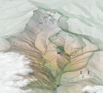 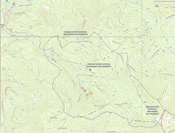 (click for larger maps) |
Touring the Cave For over 100 years guides have led tours of Oregon Caves. Today tours explore over a half mile of twisting passages. Your guide recounts the cave's natural and cultural history on the tour. Wait times can be long in summer and a fee is charged. If you are adventurous, you may be interested in the guided off-trail cave tour offered in summer. Visit www.nps.gov/orca for up-to-date information.
Safe Cave Tour Checklist
• Warm clothing for 40s°F
• Sturdy, nonslip footgear
• Watch for uneven surfaces
• Narrow, twisting passages
• 500 stairs and steep grades
• Low rock ceilings
Children must be at least 42 inches tall. There are no childcare services available.
Prohibited in the Cave
• Food, drinks, gum, tobacco
• Canes, tripods, flashlights
Help Protect the Cave
• Don't touch formations; skin oils discolor them
• Don't lean on cave walls or formations
Accessibility The cave's first room is accessible to those with canes or wheelchairs. Service animals are not allowed in the cave due to low ceilings and steep, open, or spiral staircases. Special arrangements can be made, subject to safety and resource protection. Ask at the visitor center or contact the park in advance. We strive to make our facilities, services, and programs accessible to all. For information go to a visitor center, ask a ranger, call, or check our website.
Visiting the Park Cave tours run from early spring through fall but can depend on the weather. Call the park or check our website for details. The cave is closed in winter to protect hibernating bats. Surface areas of the park are open year-round.
The park is 20 miles southeast of Cave Junction, OR, on OR 46. This is a narrow, winding mountain road—take your time and drive safely. Leave trailers at the Illinois Valley Visitor Center in Cave Junction. The park is 50 miles from Grants Pass and 76 miles from Crescent City, CA.
Illinois Valley Visitor Center in Cave Junction offers videos, exhibits, maps, and brochures on local attractions.
Camping is available late May to mid-September at the Grayback and Cave Creek campgrounds on OR 46. No hookups or showers. A fee is charged.
Lodging and food are available mid-May to late
September in the park. For information and reservations contact:
The Chateau at the Oregon Caves
PO Box 1824, 20000 Caves Highway
Cave Junction, OR 97523
www.oregoncaveschateau.com
Regulations and Safety
Do not feed wildlife. Mammals can carry rabies or bubonic plague. Pets must be
on a leash and stay on paved roads when not in a vehicle. Pets are prohibited on
trails. They disturb wildlife and can attract cougars and bears. Check your body
for ticks; ticks can carry Lyme disease or Rocky Mountain spotted fever. For
firearms regulations check the park website or ask a ranger.
Emergencies call 911
Source: NPS Brochure (2015)
|
Establishment
Oregon Caves National Monument and Preserve — December 19, 2014 |
For More Information Please Visit The  OFFICIAL NPS WEBSITE |
Documents
A Bibliography of Klamath Mountains Geology, California and Oregon, listing Authors from Aalto to Zucca for the Years 1849 to Mid-2003 USGS Open-File Report 03-306 (William P. Irwin, comp., 2003)
Accessibility Self-Evaluation and Transition Plan, Oregon Caves National Monument and Preserve, Oregon (March 2016)
An Ideal Vacation Land: The National Forests of Oregon (1923)
Assessment of Natural Resource and Watershed Condition, Redwood National and State Parks, Whiskeytown National Recreation Area, Oregon Caves National Monument NPS Natural Resource Report NPS/NRPC/WRD/NRR-2011/335 (Richard T. Golightly, Christine D. Hamilton and Sharon H. Kramer, March 2011)
Assessment of Natural Resource and Watershed Condition, Oregon Caves National Monument and Preserve NPS Natural Resource Report NPS/ORCA/NRR-2020/2207 (Jessica E. Halofsky, David L. Peterson, Harriet A. Morgan, Meade B. Krosby and John E. Roth, December 2020)
Bird Population Trends from Constant Effort Mist Netting in Oregon Caves National Monument and Preserve NPS Natural Resource Report NPS/KLMN/NRR—2016/1311 (Sarah M. Rockwell, John D. Alexander, Jaime L. Stephens and Robert I. Frey, September 2016)
By Motor and Mule to the Marle Halls (Hamilton M. Laing, Sunset, Vol. 39, November 19, 1917)
Cultural Landscapes Inventory: Oregon Caves Historic District, Oregon Caves National Monument (2014)
Cultural Landscape Report: Cultural Landscape Inventory of Oregon Caves National Monument (Cathy Gilbert and Marsha Tolon, Winter 1992)
Debris Flow hazard Assessment for the Oregon Caves National Monument USGS Water-Resources Investigations Report 83-4100 (John Friday, 1983)
Discover One of Oregon's Historic Grand Lodges: The Chateau at the Oregon Caves National Monument & Preserve (Nicole Possert, extract from Field Notes, Summer 2024; ©Restore Oregon
Domain of the Cavemen: A Historic Resource Study of Oregon Caves National Monument, 2nd edition (Stephen R. Mark, 2011), 1st edition (Stephen R. Mark, 2006)
Ecology, Pathology, and Management of Port-Orford-Cedar (Chamaecyparis lawsoniana) U.S. Forest Service General Technical Report PNW-184 (Donald B. Zobel, Lewis F. Roth and Glenn Hawk, 1985)
Effects of Climate Change on Vegetation, Oregon Caves National Monument and Preserve NPS Natural Resource Report NPS/ORCA/NRR-2020/2155 (David L. Peterson, Jessica E. Halofsky, Harriet A. Morgan and Meade B. Krosby, July 2020)
Field Report of Committee — Proposed Port Orford Cedar National Monument (April 1940)
Fire Management Plan Environmental Assessment, Oregon Caves National Monument and Preserve Draft (November 2022)
Foundation Document, Oregon Caves National Monument and Preserve, Oregon (August 2015)
Foundation Document Overview, Oregon Caves National Monument and Preserve, Oregon (January 2015)
General Data — History of Oregon Caves National Monument (undated)
General Management Plan, Oregon Caves National Monument (August 1999)
Geochemical baselines for surface waters and stream sediments and processes controlling element mobility, Rough and Ready Creek and Oregon Caves National Monument and vicinity, southwestern Oregon USGS Open-File Report 98-201 (W.R. Miller, D.B. Smith, A.L. Meier, P.H. Briggs, P.M. Theodorakos, R.F. Sanzolone and R.B. Vaughn, 1998)
Geologic Resources Inventory Report, Oregon Caves National Monument Natural Resource Report NPS/NRSS/GRD/NRR-2011/457 (Lynn K. Keller, September 2011)
Historic American Buildings Survey
Oregon Caves Chalet (HABS No. OR-146)
Oregon Caves Chateau (HABS No. OR-145)
Oregon Caves Historic District
Oregon Caves Ranger Residence (HABS No. OR-149)
Historic Structure Report: Oregon Caves Chateau, Oregon Caves National Monument (Alex McMurry, June 1999)
History of the Discovery of the Marble Halls of Oregon (E.J. Davidson, The Quarterly of the Oregon Historical Society, Vol. 23, No. 3, September 1922)
Homelands of the Siskiyou Divide: An Ethnohistory of American Indian Communities' Traditional Ties to Oregon Caves National Monument and Vicinity Pacific West Region Social Science Studies Publication No. 2008-02 (Douglas Deur, 2008)
Junior Cave Scientist Activity Book (Ages 5-12+) (2016; for reference purposes only)
Junior Ranger (Ages 6 and under), Oregon Caves National Monument and Preserve (Date Unknown; for reference purposes only)
Junior Ranger (Ages 7-10), Oregon Caves National Monument and Preserve (Date Unknown; for reference purposes only)
Junior Ranger (Ages 11 and up), Oregon Caves National Monument and Preserve (Date Unknown; for reference purposes only)
Klamath Network Landbird Monitoring Annual Report
Klamath Network Landbird Monitoring Annual Report: 2008 results from Oregon Caves National Monument, Lava Beds National Monument, and Redwood National and State Parks NPS Natural Resource Technical Report NPS/KLMN/NRTR—2009/191 (Jaime L. Stephens, John D. Alexander and Sean R. Mohren, March 2009)
Klamath Network Landbird Monitoring Annual Report: 2009 Results from Oregon Caves National Monument and Whiskeytown National Recreation Area NPS Natural Resource Data Series NPS/KLMN/NRDS—2010/043 (Jaime L. Stephens, John D. Alexander and Sean R. Mohren, April 2010)
Klamath Network Landbird Monitoring Annual Report: 2010 Results from Crater Lake National Park, Lassen Volcanic National Park, and Oregon Caves National Monument NPS Natural Resource Data Series NPS/KLMN/NRDS—2011//175 (Jaime L. Stephens, John D. Alexander and Sean R. Mohren, June 2011)
Klamath Network Landbird Monitoring Annual Report: 2011 Results from Oregon Caves National Monument, Lava Beds National Monument, and Redwood National and State Parks NPS Natural Resource Data Series NPS/KLMN/NRDS—2012/317 (Jaime L. Stephens and Sean R. Mohren, May 2012)
Klamath Network Landbird Monitoring Annual Report: 2012 results from Lassen Volcanic National Park, Oregon Caves National Monument, and Whiskeytown National Recreation Area NPS Natural Resource Data Series NPS/KLMN/NRDS—2013/536 (Jaime L. Stephens and Sean R. Mohren, August 2013)
Klamath Network Landbird Monitoring Annual Report: 2013 results from Crater Lake National Park and Oregon Caves National Monument NPS Natural Resource Data Series NPS/KLMN/NRDS—2014/689 (Jaime L. Stephens, August 2014)
Klamath Network Landbird Monitoring Annual Report: 2014 Results from Oregon Caves National Monument, Lava Beds National Monument, and Redwood National and State Parks NPS Natural Resource Data Series NPS/KLMN/NRDS—2015/816 (Jaime L. Stephens, August 2015)
Land Cover and Land Use Monitoring: 2016 Results for Oregon Caves National Monument and Preserve NPS Natural Resource Data Series NPS/KLMN/NRDS—2017/1108 (Jace Ives, Allison Snyder, Elizabeth Edson, Jacob King, Lorin Groshong and Sean Mohren, June 2016)
Landbird monitoring: 2015 Results from Lassen Volcanic National Park, Oregon Caves National Monument and Preserve, and Whiskeytown National Recreation Area NPS Natural Resource Data Series NPS/KLMN/NRDS-2016/1043 (Jaime L. Stephens, August 2016)
Marvelous Oregon Caves: A National Monument (The Oregon Caves Resort, Inc., c1930s)
Mission 66 for Oregon Caves National Monument (c1965)
Monterey furnishings of California's spanish revival Preview Only (Roger Renick and Michael Trotter, eds., 2000)
National Register of Historic Places Nomination Form
Oregon Caves Historic District, Oregon Caves National Monument (Stephen R. Mark, June 1991)
Oregon Caves Chateau Accessibility and Safety Study, Oregon Caves National Monument (Architectural Resources Group, June 2006)
Oregon Caves National Monument: A Manual for Cave Guides (David G. Lescalleet and Gregory T. Evans, 1975)
Oregon Caves National Monument: How Might Future Warming Alter Visitation? (Nicholas Fisichelli and Pamella Ziesler, June 22, 2015)
Overview of Digital Geologic Data for Oregon Caves NM (August 2011)
Park Newspaper (Oregon Caves Underworld/Cave Echoes): Summer 1986 • Summer 1987 • 1995-1996 • 1997-1998 • Summer 2000 • 2007 • 2009
Pausing at the River Styx: An Administrative History of Oregon Caves National Monument and Preserve (Stephen R. Mark, 2019)
Pictures of the Oregon Caves: "The Marble Halls of Oregon" (The Kiser Studio, c1920s)
Preserve Management Plan, Oregon Caves National Monument and Preserve Draft (2018)
Preserve Management Plan / Wild and Scenic River Study / Environmental Assessment
Newsletter #1 (Public Scoping) (Spring 2016)
Newsletter #2 (Scoping Comments Summary) (August 2016)
Newsletter #3 (Spring 2018)
Preserve Management Plan, Oregon Caves National Monument and Preserve Draft (2018)
Provisional Manual of Information, Eighth Edition (April 1, 1961)
Report on Sullys Hill Park, Casa Grande Ruin; the Muir Woods, Petrified Forest, and Other National Monuments, Including List of Bird Reserves: 1915 (HTML edition) (Secretary of the Interior, 1914)
Report on Wind Cave National Park, Sullys Hill Park, Casa Grande Ruin, Muir Woods, Petrified Forest, and Other National Monuments, Including List of Bird Reserves: 1913 (HTML edition) (Secretary of the Interior, 1914)
Resource Brief: Vegetation Inventory Project (Date Unknown)
Site Bulletins (Bi-Monthly)
2010: June 7-13 • June 14-20 • June 21-27 • June 28 - July 4 • July 5-11 • July 12-18 • July 19-25 • July 26 - August 1 • Aug. 2-8 • Aug. 9-15 • Aug. 16 - Labor Day
2011: June 2011 • Early July • Late July • Early August • Late August • Fall
2012: June 2012 • Early July
2014: June 2014
Special Report on the Wildlife of Oregon Caves National Monument and Adjacent Territory (Richard M. Bond, December 4, 1936)
Subsurface Management Plan - Environmental Assessment, Oregon Caves National Monument (John Roth, September 2005)
Subsurface Management Plan, Oregon Caves National Monument (Errata) (c2005)
The Mountains of Oregon (©W.G. Steel, 1890)
The Underworld of Oregon Caves (Roger J. Contor, 1963)
Using LiDAR to Assess Forest Structure and Fuels at the Whiskeytown National Recreation Area, Oregon Cave National Monument and Preserve, and Redwood National and State Parks (Miles LeFevre and Van Kane, Date Unknown)
Vegetation Inventory Project, Oregon Caves National Monument and Proposed Expansion Area NPS Natural Resource Technical Report NPS/ORCA/NRTR-2013/782 (Dennis C. Odion, Dominic A. DiPaolo, Lorin C. Groshong and Daniel A. Sarr, July 2013)
Water supply for Oregon Caves National Monument, southwestern Oregon USGS Open-File Report 67-172 (E.A. Oster and E.R. Hampton, 1967)
Welcome to the Oregon Caves Chateau Photo Tour (undated)
Wild and Scenic River Study, Oregon Caves National Monument and Preserve Draft (2018)
Wild and Scenic River Study, Oregon Caves National Monument and Preserve Final (2020)
orca/index.htm
Last Updated: 01-Jan-2025