|
OREGON'S HIGHWAY PARK SYSTEM: 1921-1989 An Administrative History |

|
HISTORICAL OVERVIEW
by LAWRENCE C. MERRIAM, JR.
ORIGINS OF THE OREGON STATE PARK SYSTEM
Physiographically, Oregon is blessed with outstanding natural assets superbly situated for state parks. In the west is the rugged coastline backed by the Coast Range. To the north is the scenic Columbia River, cutting its way through the Cascade Range to the sea. A Columbia tributary, the Snake River, with the Owyhee, forms the eastern state boundary. To the southwest are the Klamath Mountains with the subordinate Siskiyou Range separating Oregon and California. Mountains and picturesque valleys with ocean-seeking streams in western Oregon offer numerous scenic attractions, while in the central part of the state is a high forested volcanic plateau cut by rivers and streams. The southeastern part of the state is high desert where many of the major attractions and much of the land is federally owned. To the northeast are the Blue and Wallowa mountains with spectacular peaks, lakes and streams, again largely federal public land. In fact, 52 percent of Oregon is federal land, including most of the backbone Cascade Range, which divides the lush western third of the state from the high desert plateau.
Thus, the state park system has long been identified with the non-federal areas, particularly the Oregon coast, the Columbia River region and the Willamette Valley. An early boost for coastal park development was the 1913 declaration to the state legislature by Governor Oswald West that the Oregon beaches should be designated as a public highway. The legislature concurred, amending existing laws to include all ocean shore tidelands from the Columbia River to the California state line. This legislation exempted 23 miles of tidelands previously sold by the state. [1]
Governor West brought attention to the public use of the ocean shore as a means of travel and recreation along the coast. Though the story is more complex, as will be seen, the Oregon State Highway Commission, first established in 1913, became directors of a park system. With their related agency, the State Highway Department, and its successor, the Department of Transportation, the commissioners guided Oregon State Parks from the time authority to acquire scenic roadside strips was provided in 1921 through 1989.
There were earlier public parks of state concern. In 1871, Thomas Summers, after a long legal battle, donated Sodaville Mineral Springs in the central Willamette Valley to perpetual public use. It was taken over by the State Board of Control in 1890, but did not become part of the system of state parks until 1947. [2] Along the Willamette River, in the vicinity of the former townsite of Champoeg, Provisional Government Park was established between 1901 and 1912 to commemorate those who, in 1843, voted for a political organization to continue until the United States should establish a territorial government. After it was deeded to the Highway Commission in 1943, it became the nucleus of Champoeg State Park.
During construction of the highway east of Portland through the Columbia Gorge from 1913 to 1916, Simon Benson, Osman Royal and George Shepperd gave some park lands to the City of Portland. These later became Benson State Park, Crown Point State Park and Shepperd's Dell State Park. On adjoining National Forest land, the U.S. Forest Service created the Columbia Gorge Park in 1915. This was a strip of National Forest from one to four miles wide extending from Warrendale to Viento, adjacent to the Columbia River Highway. It was classed as more valuable for its scenic beauty and public recreation attributes than for other purposes. [3] Simon Benson became the first citizen chairman of the Oregon State Highway Commission (1917-1920).
Another concern related to highways was the protection of forest strips and scenery along state roads. Robert W. Sawyer, Deschutes County judge (1920-1927), and later a member of the Highway Commission (1927-1930), pushed for the retention of forest strips along The Dalles-California Highway south of Bend, as well as the creation of a forested park at Dillon Falls on the Deschutes. Judge Sawyer was encouraged in his efforts by Stephen T. Mather, the first director of the National Park Service, who did much to stimulate park and scenic protection on the West Coast. [4]
Oregon scenic protection received another boost in this period from Governor Ben Olcott (1919-1923), who reacted strongly to the logging of forest along the Cannon Beach-Seaside Road (later the Oregon Coast Highway). Governor Olcott assumed leadership of the scenic preservation movement in Oregon, appointing committees to study problems, and seeking support from private citizens as well as from the Oregon Legislature. Since a principal issue was the protection of forest along highways, the Highway Commission and the highway engineer were directly concerned and were cooperative in protection and beautification efforts, including the planting of roadside trees.
In 1921, Governor Olcott asked the legislature for a scenic preservation package of three major parts that would:
1. Empower the State Highway Commission to acquire rights of way along state highways for the maintenance and preservation of scenic beauty;
2. Outlaw the destructive cutting of trees along state highways.
3. Authorize the Highway Commission to acquire land for parks and parking places to be used by the traveling public.
The right-of-way and destructive cutting proposals passed, but not the parks proposal. [5]
The 1921 law authorized the Highway Commission to acquire rights of way within 300 feet of the highway centerline. Proceeding on this authority, the commission acquired several small roadside parks and waysides. The first tract given to the State Highway Commission for park purposes was Sarah Helmick State Park on the westside Pacific Highway south of Monmouth. It was given to the state in 1922 by the Helmick family. [6] In addition, trees and shrubs were planted along the highways. To aid in this endeavor an advisory committee on tree planting was appointed in 1924 by the Highway Commission. This committee included representatives from industry, the University of Oregon, Oregon Agricultural College (now Oregon State University) and the U. S. Forest Service. Along with their concern for roadside beautification, committee members also advised on selection of suitable areas. In 1928, the committee name was changed to State Park and Recreation Advisory Committee as their concern shifted to broader matters, including the location and nature of parks. [7]
In 1925, the legislature passed an act authorizing the State Highway Commission to acquire lands for the culture of trees and the preservation of scenic places along state highways, "and for parks, parking places, campsites, public squares and recreation grounds." The commission was further authorized to improve, maintain and supervise these lands and spend state highway funds for such purposes. [8]
Following the 1925 legislation, there appears to have been a definite effort to obtain larger areas, beyond the 300 feet right-of-way limit. This is noticeable in the case of two parks in Curry County, Cape Sebastian near Gold Beach, initially acquired in September 1925, and Humbug Mountain near Port Orford, first acquired in June 1926. However, over the years a great many of the park areas, especially on the coast, included minimum acreage beyond a salient point or major feature, a characteristic which causes problems in providing for adequate services and development.
In the 1920s, planning for and acquisition of land for parks and scenic protection were clearly the prerogative of the Oregon State Highway Commission by legislative authorization. Nevertheless, there arose a national feeling that state parks should be administered by a state department of conservation. The National Conference on State Parks, organized partly by Stephen T. Mather in 1921, favored a separate department of conservation for governance of all natural resources, including a state park system. By the late 1920s, both New York and California were operating in the favored direction.
In 1927, Charles G. Sauers, a leader in Indiana parks and representing the National Conference on State Parks, came to Oregon to promote the idea of a department of conservation for natural resources including the state park system. The system would thus be developed by people primarily concerned with parks, rather than the location, construction and maintenance of highways. While Sauers found support among some Portland civic leaders, the Highway Commission was opposed, particularly its chairman, H. B. Van Duzer, and Robert W. Sawyer. [9]
Sawyer's concern for park and roadside forest protection and his perception of Oregon's political scene led him to favor continued administration and development of the state park system by the Highway Commission. The legislature had supported Governor Olcott's popular scenic preservation and park program only in a limited way. It seemed doubtful that it would fund or support a park system without continued political struggle every two years. The Highway Commission, rather than being dependent on legislative appropriations, obtained its funding from dedicated gasoline taxes and automobile license fees. While the purpose of these funds was to assure good roads, there had been little objection thus far to including parks with the roads. [10] Also, the commission was increasingly successful in acquiring park lands near highways.
Under the low public profile approach used in Oregon, park lands were acquired but there was no one specifically charged with park matters. R. W. Sawyer argued for the employment of a superintendent of state parks with overall responsibility for the park system. Though Highway Commission Chairman H. B. Van Duzer favored use of the advisory committee on parks for guidance, Sawyer felt such an approach to be ineffectual. He also encouraged Governor I. L. Patterson to support an expanded park program. In May 1929, the governor appointed a State Park Commission composed of the existing Highway Commission plus two former chairmen, William C. Duby and R. A. Booth. [11] This park commission met only once, July 24, 1929, but it did develop a statement which could have been a useful policy guide for the state park system.
To create and develop for the people of the State of Oregon a state park system, to acquire and protect timbered strips on the borders of state highways, rivers and streams, to secure in public ownership typical stands of the trees native to Oregon, to maintain the public right to the use of the sea beaches of the state, to seek the protection of our native shrubs and flowers and to preserve the natural beauty of the state.
On a motion that carried, the commission adopted the report of the committee. It was then voted to carry out through the Highway Commission the purposes set forth above by:
1. Taking up with the Forest Service the matter of protecting National Forest timber along state highways and securing the development of further recreational areas.
2. Taking up with the Interior Department the matter of acquiring public lands suitable for park and recreation purposes.
3. Making arrangements with private owners for the acquisition of timbered strips along the highways and elsewhere by exchange, purchase or donation and the acquisition of typical stands of native trees.
4. Making a survey of the state to discover all desirable park and recreation sites.
5. Approving and furthering the efforts now being made by garden and nature study clubs to protect native shrubs and flowers, and
6. By seeking at the next legislative session legislation additional to that now on the books, where it is found necessary to carry out these purposes. [12]
Though many of the above stated goals were carried out, the potential site survey of the state apparently was never accomplished in a formalized way as was done in California in 1927-1928. [13] Things moved in another direction, perhaps in part due to the death of the governor, the Great Depression of 1929-1941, and the desire of the Highway Commission to internalize activities by appointing Samuel H. Boardman as the first Oregon State Parks engineer, or superintendent.
At Sawyer's urging, a number of candidates were proposed for the superintendency, including a later Parks superintendent, Mark H. Astrup, who had been recommended by A. L. Peck, member of the original advisory committee and professor of landscape architecture at Oregon Agricultural College. The commission, however, decided to employ one of its own, Boardman, who would acquire timber lands alongside highways as well as other scenic areas.
Sam Boardman was born in Massachusetts in 1874. Following schooling there and in Wisconsin, he moved west doing engineering work on various railroads. He and his family homesteaded a desert tract in eastern Oregon in Morrow County, where the present town of Boardman is named for him. The homestead was less than successful. While his wife taught school, Boardman worked at various jobs, becoming an oil crew foreman for the Oregon State Highway Department. Earlier he had done extensive and successful tree plantings in and around Boardman. He sold the idea of highway right-of-way plantings to Highway Engineer Roy A. Klein, Commissioner W. C. Duby and Governor Walter Pierce. [14]
Boardman's tree planting skill, his effectiveness with people, and his concern for scenic protection were doubtless factors in his appointment as state parks engineer in August 1929.
1. Kathryn A. Straton. 1977. Oregon's Beaches: A Birthright Preserved. Salem: Oregon State Parks and Recreation Branch, 11.
2. W. A. Langille. c. 1947. Sodaville Mineral Springs. 10 p. manuscript in Oregon State Parks and Recreation Division tiles (OSPF), Salem. Chester H. Armstrong. 1965. History of the Oregon State Parks. Salem: Oregon State Highway Department. 196-197.
3. U. S. Forest Service. 1916. Guide Map to Columbia Gorge Park, Division of Oregon National Forest, Washington. D. C. U. S. Geological Survey.
4. Thomas R. Cox. 1988. The Park Builders: A History of State Parks in the Pacific Northwest. Seattle: University of Washington Press, 32-36.
6. Oregon Slate Highway Commission. 1922. Fifth Biennial Report (Dec. 1, 1920 - Nov. 30, 1922). Salem: State Printing Department.
7. Oregon State Highway Commission. 1928. Eighth Biennial Report (Dec. 1, 1926 - Nov. 30, 1928). Salem: State Printing Department.
8. Oregon State Parks Advisory Committee. 1956. Report and Recommendations on Oregon Stale Parks. Salem: State Printing Department.
12. The statement was developed from the report of a committee consisting of R. A. Booth, R. W. Sawyer and J. M. Devers (chief counsel to the Oregon Highway Commission). Minutes of the State Park Commission, Salem: Oregon, July 24, 1929. Oregon State Parks Files (hereafter OSPF).
13. Frederick Law Olmsted, Jr. 1929. Report of State Park Survey of California. Sacramento: California State Printing Office.
14. Cox, op. cit., p. 55, 80-81.
|
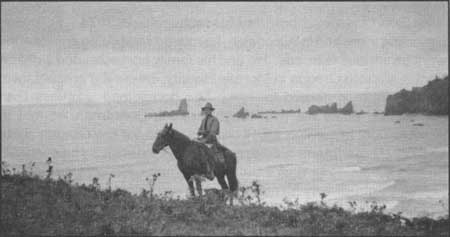
| Fig. 2 Oswald West, governor of Oregon 1911-1915 and protector of Oregon tidelands, is pictured astride his saddle horse on Crescent Beach in present-day Ecola State Park. In the background are Sea Lion Rock off Ecola Point and Tillamook Rock Light, offshore in the distance. In 1913, West declared the wet-sand beaches a public highway and was backed by legislative action which laid the foundation for later initiatives concerning recreational use of the ocean shores. Writing to Parks Superintendent Chester Armstrong on this picture post card in 1958, the former governor recalled the historic ride he made some 45 years earlier from the area of Elk Creek down Cannon Beach and via Arch Cape over Neahkahnie Mountain mail trail to Nehalem. "This was when and where I caught my inspiration," he explained. 1913. Photographer unknown. Oregon State Parks. |
| <<< Previous | <<< Contents>>> | Next >>> |
overview.htm
Last Updated: 06-Aug-2008