|
OREGON'S HIGHWAY PARK SYSTEM: 1921-1989 An Administrative History |
|
HISTORICAL OVERVIEW (continued)
CHANGES IN PLANNING, FUNDING AND PUBLIC RESPONSE
An important development of the 1970s which affected resource management and coordinating activities of the State Parks agency was creation of the Land Conservation and Development Commission (LCDC) and its subordinate department. Recognizing that uncoordinated use of the land creates many problems in development, the environment and general public welfare, the Oregon Legislature enacted the 1973 Land Use Law. This law provided for the identification of critical areas of statewide concern, establishment of standards for land use planning by state and local agencies, coordination of statewide activities and the initiation of a program for citizen involvement in land use planning. [1] A list of 19 goals was established to cover the concerns.
Goal 5 of LCDC statewide planning guidelines concerned open space, scenic and historic areas, and natural resources. Opportunities for coordination between LCDC and State Parks were provided for additionally by Goal 8, relating to statewide comprehensive outdoor recreation planning; Goal 15, pertaining to the Willamette River Greenway; Goal 17, coastal shorelands; and Goal 18, beaches and dunes. [2]
Following the energy crisis in the late 1970s, when gasoline tax revenues were severely reduced, there was public pressure for non-gas tax funding of state park and recreation operations. In 1980, the public passed a constitutional amendment precluding use of the Oregon Highway Fund for state police and park purposes. The Parks and Recreation agency has since been supported by General Fund monies from the legislature, park user fees, recreation vehicle (RV) fees, federal funds and miscellaneous sources. [3] While severance of the State Parks agency from the Highway Fund ultimately has created greater public awareness of state park matters, shortages in state General Fund monies resulted in park budget reductions. In the years from 1980 to 1989, while the Parks and Recreation Division remained in the Department of Transportation, only limited funds were available for state park purposes.
The major changes in American society that were ongoing through the 1960s and the 1970s were reflected in patterns of park use. In the summer of 1970, a large rock music festival was held in Milo McIver State Park on the Clackamas River near Estacada. Called Vortex I, it involved upwards of 40,000 people during the period August 21 to September 2. McIver Park was chosen for the event by the governor's office to avoid possible confrontation between disillusioned youth and a national convention of the American Legion scheduled for the same period in nearby Portland. The event was carefully planned by State Parks officials and representatives of the festival, who provided their own monitors. While there were some minor injuries and first aid cases, and cleanup was costly, there were no major incidents and the park was opened to the general public again four days after the festival ended. [4] Careful monitoring and persuasion succeeded in the place of physical enforcement. At the time there was criticism from some quarters concerning the use of a state park for a rock festival, but park managers handled the unusual gathering in a tolerant and painstaking manner, thus defusing a potentially volatile situation.
During this period, nude bathers presented another unconventional park user group. Nudists used Rooster Rock State Park on the Columbia River east of Portland for many years, but in the late 1970s conflict between nudists and other park visitors provoked concern which led to abortive legislative proposals to ban nudism. [5] Following considerable internal policy debate and counsel with the Advisory Committee, a section of the park was designated for the use of nude bathers. [6]
Another challenge of the 1970s which continues to the present day was creation of the Banks-Vernonia State Park occupying an abandoned railroad right-of-way in Washington and Columbia counties. Abandoned by the Burlington Northern Railroad in 1973, the property was ultimately acquired by the Oregon State Highway Division and made available to the State Parks agency for a linear park. Such parks have been most successful in other parts of the country.
The linear park proposal was not popular with adjacent landowners, however, who were concerned about the prospect of trespass and vandalism. They were encouraged by a court decision which favored neighboring landowners and effectively limited public acquisition to a single parcel of the right-of-way. In 1979, the State Parks agency, supported by the Parks Advisory Committee, decided on a waiting stance pending legislative action, which did not come. [7]
During the 1980s, plans were developed and legislative appropriations sought for park development of the former railroad right-of-way. A public hearing on the proposed Banks-Vernonia park in 1987 generated considerable opposition, but also prompted a feasibility study by outside consultants. The consultants' report supported the need in Washington and Columbia counties for a linear park with hiking, biking and equestrian amenities. [8] By the end of 1989, though six lawsuits concerning property rights remained to be settled, local opposition to the park had declined, while support increased among community and user groups.
During the 1980s, the State Parks agency made a number of efforts to offset rising costs and declining income caused by the loss of Highway Fund revenues, the reduction of federal aid programs for parks and recreation and the depressed Oregon economy. One such effort was creation of the park host volunteer program in March, 1980. Originally started in some state park campgrounds, this successful program has expanded over the years to encompass all the campgrounds and many other facilities in the Oregon State Parks system. Park hosts receive free use of a campsite for a month or more in exchange for helping campers and providing information about parks throughout Oregon. They do not collect fees or enforce regulations.
In 1985, the Oregon Legislature authorized the administrator of the Oregon State Parks and Recreation Division to make agreements with private, non-profit cooperative associations to foster or operate interpretive and educational facilities at local, regional or state parks. [9] The first such organization to be formed, Friends of Tryon Creek Park, had been established as early as 1969 and had been instrumental in the creation of Tryon Creek State Park in 1971. There are now nine such associations aiding the park system through fund-raising and volunteer work on behalf of individual state parks. The others are operating at Fort Stevens (1979), Champoeg (1980), Crown Point Vista House (1982), Shore Acres (1986), Silver Falls (1986), Collier (1987), Cape Blanco (1988), and Yaquina Bay (1988).
Since the early years of the 20th Century, and sporadically through the 1930s, 1950s and up to the present, there has been agitation for a park authority for the Columbia River Gorge -- one that included both Oregon and Washington, as well as the federal government. In 1915 a Columbia Gorge park was created on National Forest lands between Warrendale and Viento on the Oregon side of the gorge. Gradually, thereafter, both the state of Oregon and the U. S. Forest Service acquired gorge lands valuable primarily for scenic and recreational purposes. The first public body formed to study park development in the gorge was the Columbia Gorge Committee of the Pacific Northwest Regional Planning Commission. It issued a report in 1937.
The Columbia River Gorge Commission, organized in Oregon in the 1950s, continued for many years to acquire land for scenic protection and recreation. The commission ultimately was joined by a Washington Columbia Gorge Commission and a coalition of Columbia River Gorge groups, including local and state advocates and federal agencies. All were interested in protection of the scenic and recreational potential of the region. Several bills were introduced in the United States Congress to provide a federal framework for protection of the Gorge. In 1986, an act of Congress created the Columbia Gorge National Scenic Area of some 290,000 acres. It was divided into three provinces. Urban areas generally were held to be exempt from provisions of the act. Nearly half of the remaining land was made the province of a special commission established by bi-state agreement with the cooperation of six local counties. The remaining lands were placed in special management areas administered by the U. S. Forest Service, also charged with carrying out the overall management of the Scenic Area. The Forest Service worked with state and local government units as well as citizen groups to develop an overall management plan. [10]
In 1983, a State Parks cost responsibility study was initiated to confront the issue of financing park operations. The study concluded that 41 to 44 percent of the State Parks Division budget should be provided by users, through fees and charges, and 56 to 59 percent should come from general tax revenues. This meant that the legislature's General Fund portion of the budget would increase from 23 to some 50 percent of the total costs of operation. [11]
After seeing the findings of the cost responsibility study, Director Talbot sought reaction. This was accomplished in 1985 by meeting with media people and by a series of 13 public sessions called "town hall" meetings that were held throughout Oregon. Attendees received a questionnaire on state park issues prior to the meetings. At the town hall meetings, presentation of background information on park matters was followed by question-and-answer periods covering over 50 interest areas.
Governor Victor Atiyeh agreed to a statewide meeting to discuss the status of state parks in Oregon. Accordingly, the Governor's Conference on the Future of Oregon State parks was held in Salem December 2 and 3, 1985. Over 140 people attended the governor's conference devoted to such issues as financial stability, fees and charges, volunteers, constituency and tourism development. Among the goals recommended at the conference were reconsideration of Highway Fund support for state parks; more General Fund support; expansion of interpretation and education efforts, as well as tourism promotion; assumption of a stronger statewide park and recreation advocate role, and aggressive promotion of use of state parks. In addition, the consensus of the conferees was that the State Parks organization should not enter the resort business, and the traditional mission of protection of resources and scenery should be pursued. [12]
These recommended goals, coupled with recreational needs identified in the ongoing Statewide Comprehensive Outdoor Recreation Planning process (SCORP), helped initiate a long-range strategic plan for Oregon State Parks looking ahead to the year 2010. In December, 1987, the Oregon Transportation Commission appointed the State Parks 2010 Citizen Committee, headed by Lynn Newbry of Talent, and charged its members to make recommendations for and aid the production of a 20-year plan. The 2010 Plan was produced in December, 1988, and provided dollar estimates for committee recommendations on the following subjects: rehabilitation of park facilities, land acquisition, campgrounds, special needs of the public, interpretive services, ocean beaches, recreational trails, scenic waterways, marketing the system and coordination of outdoor recreation in Oregon. [13] The 2010 Plan stated a need for increased services and increased funding for Oregon State Parks.
When presented the plan, Governor Neil Goldschmidt, asked whether the necessary funds for implementation were likely to be available under prevailing circumstances. On receiving a doubtful answer, the governor suggested State Parks probably should be in a separate department under its own commission. [14] The governor backed his position with public statements promoting a separate Parks agency.
A bill was introduced in the 1989 Oregon Legislature for the creation of a State Parks and Recreation Department. Although there was some opposition to the transfer, the measure was passed by both branches of the legislature and signed by Governor Goldschmidt on August 2, 1989. The governor signed the act on the steps of the capitol in Salem on the occasion Parks chose to celebrate its 60th year as an organized agency.
The act became effective January 1, 1990, and, among other things, it created a State Parks and Recreation Department separate from the Department of Transportation, established a governor-appointed, seven-member State Parks and Recreation Commission having authority to appoint the department director, and it defined duties of the director and departmental authority. [15] David G. Talbot was appointed first director.
At the time the State Parks and Recreation Department Act was passed, there were 223 state-held parks, including 89,934 acres of land, some 46 percent of which is located on the Oregon coast. As to use, Oregon has the fifth largest total day and overnight park use in the country -- some 39,000,000 visits up from 10,835,000 visits in 1959, when 174 parks covered 59,490 acres.
Thus came to a close a 68-year period of acquisition, development and operation of a highway-oriented state park system. The sections which follow may be helpful to those wishing to pursue the details of agency history. They include a discussion of sources for research, a directory of current park holdings and a memoir by David Talbot, who, as chief administrator, guided the system through the period of greatest expansion and diversification.
1. Oregon Secretary of State, Oregon Blue Book 1975-1976. p. 43-44.
2. Land Conservation and Development Department. 1985. Oregon Statewide Planning Goals.
3. Oregon State Parks and Recreation Division. 1988. Oregon State Parks 2010 Plan.
4. David G. Talbot to Loran L. Stewart. September 8, 1970. Summary, Vortex I event at Milo McIver State Park. OSPF.
5. Rooster Rock Files, 1974-1978. OSPF.
6. Minutes of the State Parks and Recreation Advisory Committee. February 3, 1978.
7. David G. Talbot to Advisory Committee, June 7, 1979; conference call. June 11, 1979, minutes of the State Parks and Recreation Advisory Committee.
8. Klein Consulting Engineers. K. J. Won. George M. Otten and Associates. 1988. A Feasibility Study for the Proposed Banks/Vernonia Linear Park. Forest Grove. Oregon.
9. Oregon State Parks and Recreation Division Cooperative Associations Administrative Rule.
10. USDA Forest Service. 1986. "Columbia Gorge National Scenic Area New Law." Forest Service News. Portland. Oregon. OSPF.
11. Oregon State Highway Division. 1883. Oregon State Parks Cost Responsibility Study.
12. Oregon State Parks and Recreation Division. c. 1985. Governor's Conference on the Future of the Oregon State Parks. Salem.
13. Oregon State Parks and Recreation Division. 1988. Oregon State Parks 2010 Plan.
14. David G. Talbot. conversation with L. C. Merriam. Jr., May 2, 1990.
15. Oregon Legislative Assembly. 1989. House Bill 2904. Engrossed.
|
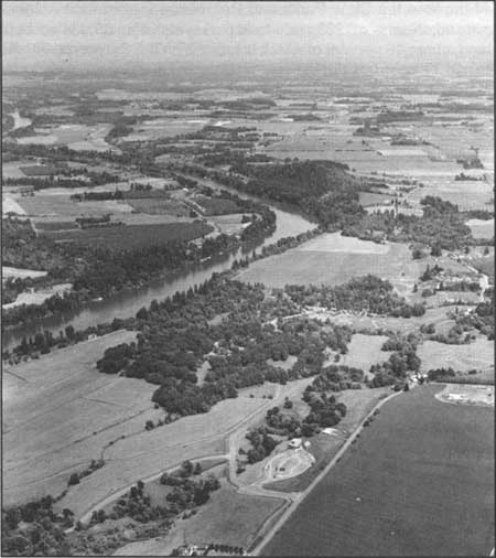
| Fig. 19. Lower central Willamette Valley, State Parks Region I. Aerial perspective view to the east, toward the Cascade Range, overlooking Champoeg State Park on the Willamette River. The Champoeg State Park visitor orientation center, identified by the oval outline of its parking area, is in the foreground. Bicycle paths lead upriver from an overnight campground in the grove of trees to the historic townsite area and former boat landing sites. The park commemorates the settlers' decisive action in 1843 leading to formation of the Provisional Government of Oregon. Champoeg State Park is one of the major recreational sites enhanced by development of the Willamette River Greenway. 1951. Oregon Department of Transportation Photo #A785-147. |
| <<< Previous | <<< Contents>>> | Next >>> |
overview4.htm
Last Updated: 06-Aug-2008