|
Palo Alto Battlefield National Historical Park Texas |
|
 NPS photo | |
Nations in Conflict: A Fight over Texas
"The jurisdiction of the United States . . . has passed the capes of Florida and been peacefully extended to the Del Norte." That's how US President James K. Polk, in his December 1845 message to Congress, characterized the recent annexation of Texas by the United States, with a boundary along the Rio Grande (or Rio Bravo del Norte). He had campaigned for the presidency with a pledge to extend the United States to the Pacific Ocean, and the addition of the Republic of Texas as the 28th state represented a major step toward that goal.
Mexico, however, challenged annexation. Although Texas had severed ties with Mexico in 1836, many Mexican leaders refused to recognize its independence and denounced the US move as an attack on Mexico. Even those Mexicans who had accepted the loss of Texas bristled at the claim that the Rio Grande formed the boundary of the new state. Mexico had always mapped Texas as a much smaller region—bounded in part by the Nueces River. Polk's call for a Rio Grande border placed a huge expanse of territory in dispute.
Polk attempted to force a settlement of the boundary issues. In the summer of 1845, he sent an envoy to Mexico City to negotiate an agreement. He also ordered Gen. Zachary Taylor to lead a 4,000-man army to Corpus Christi, on the Nueces River. Officially, Taylor's army had moved to defend Texas against threatened Mexican attacks. But the show of force also was designed to convince Mexican leaders to accept the loss of Texas, agree to the Rio Grande boundary, and, perhaps, even sell the New Mexico and California territories.
The tactic failed. In Mexico, hard-line Gen. Mariano Paredes y Arrillaga marched to the capital, seized control of the government, and announced that he would discuss nothing but the return of Texas. Clear battle lines had been drawn.
Polk continued to exert pressure by ordering Gen. Taylor onward to claim the Rio Grande. In March 1846 Taylor led his troops south, occupied the bank of the river across from the Mexican city of Matamoros and began construction of Fort Texas, an earthen fieldwork that would serve as his base of operations. Gen. Paredes showed equal resolve. He expelled the US envoy from Mexico, sent thousands of troops to Matamoros, and appointed Gen. Mariano Arista to command this Army of the North.
It was Polk who finally hesitated. Many political foes at home challenged his claims to the Rio Grande boundary, and Polk realized that by moving troops to the other side of the Rio Grande or initiating conflict, he risked turning the American public against him. Instead, he ordered Taylor to wait for Mexican forces to cross the Rio Grande, which Polk could portray as an attack on American territory.
He didn't have long to wait. Arista believed that Taylor's army had marched hundreds of miles into Mexican territory and, in late April, ordered troops across the Rio Grande to confront the Americans. Taylor heard rumors of this Mexican movement and sent a 63-man scout party, headed by Capt. Seth Thornton, to investigate. Some 28 miles west of Fort Texas, at a tiny settlement called Rancho de Carricitos, Thornton's party suddenly found itself surrounded by 1,600 Mexican soldiers under the command of Gen. Anastasio Torrejon. In a brief skirmish, 11 US soldiers were killed and most of the rest taken captive.
When President Polk learned of the "Thornton skirmish," on May 10, 1846, he announced that Mexico had "shed American blood upon . . . American soil" and demanded action. Although some legislators referred to the coming conflict as "the murder of Mexicans upon their own soil," Congress voted to declare war on May 13, 1846. Less than six months after Polk had announced the peaceful extension of the nation's southern border to the Rio Grande, the United States and Mexico fought to decide the matter.
US President James K. Polk added a vast area to the United States in the war with Mexico. But critics including Abraham Lincoln opposed his use of the military to serve his expansionist goals.
Mexican President Gen. Mariano Paredes y Arrillaga rebuffed US territorial claims. By marching his troops to the Mexican capital, however, he weakened Mexican defenses along the Rio Grande.
The Opposing Forces
The two armies that faced each other on the Rio Grande were as different as the nations they represented. Mexico's officers lacked formal training but had been tested in battle. Some had clashed with US forces a decade earlier, in the Texas Revolution. Many of the US officers were young, with limited combat experience, but well-educated in the arts of war at the US Military Academy. Mexico filled its ranks with draftees, often from indigenous communities and the margins of society. The US Army was made up of volunteers. Many were immigrants who sought a place in their new country.
Gen. Mariano Arista commanded an Army of the North much larger than Gen. Taylor's force. Both sides had many infantry or foot soldiers, armed with smoothbore muskets. Taylor's men carried recently forged guns, while the Mexican soldiers bore older, often faulty weapons.
Gen. Arista commanded a larger, much admired cavalry. His lancers could charge across a field and swiftly engulf their enemy. Gen. Taylor's army included only a small force of dragoons, or mounted infantrymen. But his aptly named "Flying Artillery" regiments could quickly reposition their lightweight cannon to repel cavalry charges. The US cannon, although fewer in number than Arista's, also had greater range and fired a variety of multiple-shot projectiles.
War Begins on the Rio Grande
After the skirmish at Rancho de Carricitos, Gen. Arista focused on Fort Texas, a US outpost on the Rio Grande. He immediately began moving more troops across the river in an effort to surround the isolated earthwork" In response, Gen. Taylor marched most of his army to a coastal base at Point Isabel on the Gulf of Mexico, to meet the supply ships that would provision the troops to ride out a prolonged siege. He left 550 men, commanded by Maj. Jacob Brown, to defend the fort. Arista's men then surrounded the fort from positions on both sides of the Rio Grande. On May 3 Gen. Arista ordered his artillery to open fire.
After gathering supplies and ammunition, 2,300 US troops with 200 supply wagons marched from Point Isabel on May 7, to break the siege at Fort Texas. General Arista closely watched their advance. On the morning of May 8, 1846, he positioned 3,200 troops halfway between Matamoros and Point Isabel, where the road crossed the Palo Alto prairie. The two armies dueled fiercely for four hours. Despite the larger numbers of Mexican infantry, Taylor's 18-pounder siege cannon dominated, pounding Arista's lines with exploding shot. The US Army's agile, quick-firing "Flying Artillery," led bv Maj. Samuel Ringgold and Capt. James Duncan, turned back Mexican cavalry charges. Gen. Arista's soldiers held their ground, but paid a heavy toll: 100 dead and 125 wounded. Taylor's force counted only 9 killed and 17 wounded.
The next morning, Arista withdrew his battle-weary soldiers five miles to Resaca de la Palma (also known as Resaca de la Guerrero). He hoped that the dense chaparral of the former riverbank would shelter his troops from the potent US cannon fire. Taylor's troops pursued the Mexicans and, on the afternoon of May 9, fought them hand-to-hand. Skilled at such fighting, the American army quickly overran the Mexican lines. A cavalry charge into the heart of the Mexican position then broke Arista's resistance and forced him to retreat across the Rio Grande. The siege of Fort Texas was over. Mexican losses were 160 killed, 228 wounded, and 159 missing, including many who drowned trying to cross the river. US losses at Resaca de la Palma were 45 killed and 97 wounded, but the US Army now firmly held the land north of the Rio Grande, where Mexican forces never again effectively challenged the US Army.
Despite the decisive US victories on the Rio Grande, the war did not end quickly. Almost two years later, after the capture of their capital city, Mexican leaders finally agreed to surrender. With the 1848 Treaty of Guadalupe Hidalgo, they renounced claims to Texas, accepted the Rio Grande as the boundary, and sold vast stretches of other territory to the US.
Gen. Mariano Arista was removed from command after the defeats on the Rio Grande, but the respected general became Secretary of War in 1848 and President of the Republic of Mexico in 1851.
Zachary Taylor's victories in the US-Mexican War thrust him into a national spotlight. Despite his lack of political experience the popular general was elected President of the United States in 1849.
Gen. Pedro de Ampudia served under Arista and replaced his commander after the battles on the Rio Grande. Later, he too fell from grace after his defeat at Monterrey.
Maj. Samuel Ringgold devoted years to developing the "Flying Artillery." Although struck by a Mexican cannon ball at Palo Alto, he lived long enough to see his efforts succeed.
Capt. James Duncan's daring use of light artillery played a major role in deciding both the Palo Alto and Resaca de la Palma battles.
Gen. Rómulo Díaz de la Vega fell captive at Resaca de la Palma but his refusal to retreat earned him respect from soldiers in both armies.
Lt. Ulysses S. Grant, one of many young officers in Zachary Taylor's army, later rose to prominence in the Civil War.
Palo Alto Battlefield Today
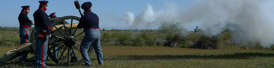
On May 8, 1846, US and Mexican troops clashed on the coastal prairie of Palo Alto, where the Rio Grande empties into the Gulf of Mexico. The ensuing two-year conflict changed the map of North America. Palo Alto Battlefield National Historical Park preserves and interprets the site and memory of that battle, vividly described in dozens of letters and diaries written by soldiers.
The Palo Alto Battlefield includes 3,400 acres of prairie and dense chaparral. The battlefield is being restored to its 1846 state and its trails, facilities, and visitor services are under development. The battlefield is located at 7200 Paredes Line Rd. (FM 1847) in Brownsville, TX, just north of the FM 511 intersection. Open daily 8 am to 5 pm.
The Resaca de la Palma and Fort Brown sites, both National Historic Landmarks, will also be preserved. Today the Resaca de la Palma Battlefield lies on Paredes Line Rd. in the heart of Brownsville, which has swallowed up much of the original scene. But 38 acres of the battlefield survive. In 2011 it became a second unit of Palo Alto Battlefield National Historical Park.
Fort Brown has suffered over time from the effects of erosion and levee construction on the Rio Grande. A few earthen mounds near the Fort Brown Golf Course are all that remain. Palo Alto Battlefield National Historical Park is cooperating with private and public partners to preserve Fort Brown for public enjoyment and education.
 (click for larger map) |
It's Still a Battlefield . . .
When Mexican and United States troops clashed on the Palo Alto Battlefield, cannon blasts and musket fire were not the only dangers. In the field's harsh environment they also encountered poisonous snakes and insects, and prickly plants. These natural hazards remain today. Please minimize your risk by following the park's safety guidelines.
Stay on marked paths and in designated areas; do not wander onto the prairie or into the brush. • Be alert for snakes, thorny plants, stinging insects, and other plant and animal threats. • Drink plenty of water and guard against heat and sunstroke. • Report any perceived dangers to a park ranger.
Help us protect this special place. Please respect the battlefield and the memory of the men who fought and died here. • Federal laws protect all natural and cultural features in the park. • Metal detectors and digging are prohibited. • Please place any litter in trash cans. • Hunting is prohibited. • For firearms regulations check the park website.
Accessibility We strive to make our facilities, services, and programs accessible to all; call or check our website.
Source: NPS Brochure (2013)
|
Establishment
Palo Alto Battlefield National Historical Park — March 30, 2009 |
For More Information Please Visit The  OFFICIAL NPS WEBSITE |
Documents
A Summary of Biological Inventory Data Collected at Palo Alto Battlefield National Historical Park: Vertebrate and Vascular Plant Inventories NPS Natural Resource Technical Report NPS/GULN/NRTR—2010/401 (November 2010)
A Thunder of Cannon: Archeology of the Mexican-American War Battlefield of Palo Alto (HTML edition) Southwest Cultural Resources Center Professional Paper No. 52 (Charles M. Haecker, 1994)
Foundation Document, Palo Alto Battlefield National Historic Site, Texas (June 2013)
Foundation Document Overview, Palo Alto Battlefield National Historic Site, Texas (May 2014)
General Management Plan, Environmental Assessment: Palo Alto Battlefield National Historic Site Draft (1997)
Geologic Map of Palo Alto Battlefield NHP, Texas (2013)
Geologic Resources Inventory Report, Palo Alto Battlefield National Historical Park NPS Natural Resource Report NPS/NRPC/GRD/NRR-2013/710 (T.L. Thornberry-Ehrlich, September 2013)
Gulf Coast Network Breeding Bird Monitoring Report: 2011 and 2012 Results from Palo Alto Battlefield National Historical Park NPS Natural Resource Data Series NPS/PAAL/NRDS—2013/486 (Eric T. Linder, May 2013)
Gulf Coast Network Breeding Bird Monitoring Report: 2013 Results from Palo Alto Battlefield National Historical Park NPS Natural Resource Data Series NPS/PAAL/NRDS—2014/619 (Whitney Granger, February 2014)
Gulf Coast Network Winter Bird Monitoring Report: 2012 and 2013 Results from Palo Alto Battlefield National Historical Park NPS Natural Resource Report NPS/GULN/NRR—2015/908 (Kenneth D. Pruitt, January 2015)
Integrated Vegetation Management Plan and Environmental Assessment, Palo Alto Battlefield National Historical Park (September 2013)
Junior Ranger Booklet, Palo Alto Battlefield National Historical Park (Date Unknown; for reference purposes only)
Landscape Classification and Historic Analysis, Palo Alto Battlefield National Historical Park (Elijah Ramsey III, Gene Nelson and Yao Y. Yan, 2003)
National Register of Historic Places Nomination Form
Fort Brown (Bruce Westerhoff, August 1985)
Palo Alto Battlefield (Patricia Heintzelman, May 12, 1975)
Resaca de la Palma Battlefield (Patricia Heintzelman, May 6, 1975)
Natural Resource Condition Assessment, Palo Alto Battlefield National Historical Park NPS Natural Resource Report NPS/PAAL/NRR-2013/723 (Andy J. Nadeau, Shannon Amberg, Kathy Kilkus, Sarah Gardner, Michael R. Komp, Jacob Zanon and Barry Drazkowski, October 2013)
Newsletter (The Palo Alto Gazette): Vol. 2 Issue 3 (Summer 1999) • Vol. 3 Issue 2 (Summer 2001) • Vol. 4 Issue 1
Papers of the Second Palo Alto Conference (Harriett Denise Joseph, Anthony Knopp and Douglas A. Murphy, eds., 1997)
Proceedings of the First Annual Palo Alto Conference (Aaron P. Mahr Yáńez, ed., 1994)
Reptile & Amphibian Monitoring at Palo Alto Battlefield National Historical Park: Data Summary, Monitoring Year 2012 NPS Natural Resource Data Series NPS/GULN/NRDS—2013/557 (Robert L. Woodman, September 2013)
Reptile & Amphibian Monitoring at Palo Alto Battlefield National Historical Park: Data Summary, Monitoring Year 2013 NPS Natural Resource Data Series NPS/GULN/NRDS—2014/649 (Robert L. Woodman, April 2014)
State of the Park Report, Palo Alto Battlefield National Historical Park, Texas State of the Park Series No. 30 (2016)
Palo Alto Battlefield National Historic Site - Brownsville - Texas
paal/index.htm
Last Updated: 07-Apr-2025