.gif)
Parks for America
MENU
|
Parks for America
|

|

|
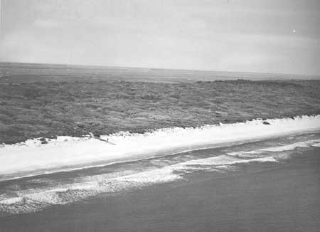
| Cumberland Island, Ga., was noted as of national significance by the Seashore Recreation Area Survey of the Atlantic and Gulf Coasts, completed by the National Park Service in 1955. The island has broad beaches and magnificent live oak forests. |
GEORGIA
GEORGIA lies on the south Atlantic coast and was the southernmost of the Thirteen Original Colonies. From the seacoast to the mountains there are abundant resources which, if properly protected and developed, can offer ample outdoor recreation opportunities for residents and out-of-State visitors.
The State population increased 14 percent in the past decade to reach 3,943,116 in 1960. Projections indicate it may reach 4,579,000 by 1976. The population density averages 68 persons per square mile and ranges from 4.4 in Echols County bordering Florida, to 1,063 in Fulton County (Atlanta). From 1950 to 1960 the urban population increased 39 percent, while the rural population decreased 6 percent, making the State total 55 percent urban. The tourist industry, with an estimated expenditure of $400 million in 1959, ranked fifth in importance to the economy of the State, which is experiencing great industrial expansion. The role of outdoor recreation can be enlarged by developing potential recreation lands on several of the offshore islands, along the major rivers and at large reservoirs.
The many miles of coastline, the Intracoastal Waterway, numerous rivers, bayous, reservoirs, and several natural lakes located in limestone sinks in the southern part of the State are basic resources that provide year-round, statewide, water-oriented recreation opportunities. The southwestern section provides outstanding upland bird hunting. The majority of the State is forested, which lends attractiveness to the mountains and water areas in the State.
Georgia history from the colonial period through the Civil War is told in the numerous historic sites and buildings preserved throughout the State. Numerous archeological sites reveal the prehistory of the State. The Stallings Island site possesses exceptional value and is eligible for National Historic Landmark status.
EXISTING PUBLIC AREAS
NATIONAL: The National Park Service administers one national military park, three national monuments, and one national battlefield park, totaling 15,480 acres. The 1960 attendance was 1,569,000. There are 2 national forests totaling 775,716 acres and including 46 recreation areas with 354 acres administered by the Forest Service. The 1960 attendance was 1,361,000. The Bureau of Sport Fisheries and Wildlife manages national wildlife refuges comprising 374,717 acres. Six reservoirs (four partly in adjacent States, one under construction and one filling) are managed by the Corps of Engineers and have 256,054 water-acres. The Tennessee Valley Authority administers three reservoirs (one partly in North Carolina) with a total of 14,420 water-acres. The 20 access points received an attendance of 552,450 in 1960.
STATE: The Division of State Parks administers 35 parks and related areas, totaling 29,890 acres. The attendance in 1960 was 3,449,218. The Georgia Historical Commission administers 14 historic shrines, containing 203 acres. The Jekyll Island State Park Authority administers one park of 11,000 acres. The Franklin D. Roosevelt Memorial Commission administers a 4,000-acre memorial, and the Stone Mountain Memorial Association administers a 3,000-acre memorial park. Other State areas, not included in the tabulation, are a 37,500-acre State forest and 14 areas with a total of 400,000 acres, administered by the Game and Fish Commission.
LOCAL: There is one local nonurban area of 150 acres.
QUASI-PUBLIC: The portion of the Appalachian Trail in Georgia is 45 miles in length.
PRIVATE ENTERPRISE: Private enterprise is becoming increasingly active in providing facilities on and near popular reservoirs and along the Intracoastal Waterway. Two major paper companies now allow public hunting and fishing on their lands. A large number of landowners with developed ponds are broadening the opportunities for local fishing.
PARK AND RELATED NEEDS
Due to the great industrial expansion in the State, immediate attention should be given to the acquisition of such irreplaceable values as sea islands, marshes, free-flowing streams, historical and archeological sites before they are appropriated. Recreational opportunities are particularly lacking in the Macon-Augusta areas, and the provision of close-in day-use facilities is also needed for other metropolitan centers. Scenic routes for pleasure driving need recognition and preservation through zoning and other State and local action.
The State park system is reasonably well established, but there is need for further development of existing parks. The system needs to be supplemented with historic trails, recreation waterways, and free-flowing streams.
Two major problems are pollution (notably in the Savannah and Altamaha Rivers) and urban spread. The metropolitan areas are expanding without provision for recreational areas for a growing population.
Existing State recreation areas now provide 48,100 acres. No major nonurban local areas were identified. The need is great and would not be met even if all the 76,400 acres in identified potential areas of State significance and the 8,000 acres of potential local areas were acquired and developed.
RECOMMENDATIONS
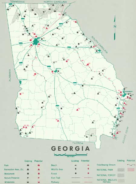
Existing recreation resources and many potential areas are shown on the accompanying tabulation and map. Providing needed outdoor recreation opportunities calls for a prompt and determined program of action, and the following recommendations are offered to aid in achieving Georgia's park and recreation goals.
NATIONAL: Establishment of Cumberland Island as a national seashore, and of a Suwannee National River, a portion of which would be in Georgia. A study for the possible 120-mile extension of the Blue Ridge Parkway in Georgia, as authorized by Congress.
STATE: Enlargement of the State park system to preserve significant recreation resources by establishment of 11 recreation areas, 6 monuments, and further study of 6 other areas.
Study of portions of the Flint and Ogeechee Rivers for possible preservation as free-flowing streams.
LOCAL: Acquisition and development of four local parks.
Supporting recommendations include:
1. Establishment of a system of historic and scenic roads that will permit a leisurely and educational enjoyment of the landscape.
2. Strengthening water pollution control measures to raise water quality for recreation use.
3. Investigation of the feasibility of restoring for public use historic Indian foot trails.
4. Establishment of metropolitan planning commissions for principal cities not now served by such commissions. These could assist adjacent counties in planning and assessing their recreation needs.
(Table omitted from online edition)

|
| (click on image for an enlargement in a new window) |
NEXT >>>
|
|
Last Modified: Mon, Sep 6 2004 10:00:00 pm PDT
parks_america/georgia.htm
 Top
Top