.gif)
Parks for America
MENU
![]() Findings and Recommendations
Findings and Recommendations
|
Parks for America
|

|
IOWA
LOCATED between the Mississippi River on the east and the Missouri and Big Sioux Rivers on the west, Iowa is predominantly level to rolling farmland broken by bluffs along rivers in the north east and southwest.
|
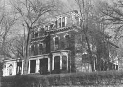
| Grenville M. Dodge, one of the world's great railroad builders, lived in this fine example of Victorian architecture. The house, in Council Bluffs, Iowa, deserves consideration as a State historic monument. |
The 1960 population was 2,727,537, an increase of 5.2 percent over 1950. Projections indicate an increase to 3,266,000 by 1976. The population is distributed rather evenly over the State, with 53 percent residing in urban areas. There are 7 cities having more than 50,000 population. The average density is 49 per square mile.
River valleys in the northeast part of the State are bordered by deeply eroded and wooded limestone bluffs. Along the western border are loess hills. Wooded valleys of the Mississippi and Missouri Rivers add attractiveness. The few natural lakes are found in the northwest and are supplemented by existing or proposed reservoir impoundments. Historic and archeological sites reveal vanished Indian cultures as well as more recent history. The Sergeant Floyd monument and Grenville N. Dodge House possess exceptional value in commemorating the history of the United States and are eligible for Registered National Historic Landmark status.
EXISTING PUBLIC AREAS
NATIONAL: The National Park Service administers 1 national monument of 1,382 acres, which had an attendance of 60,000 in 1960. The Corps of Engineers operates one reservoir of 3,800 acres. The Forest Service operates between 3,000 and 4,000 acres of land-utilization projects. The Bureau of Sport Fisheries and Wildlife administers four wildlife refuges of 64,965 acres.
STATE: The State Conservation Commission, Lands and Water Division, administers 87 parks, recreation areas, monuments, preserves, and beaches with a total of 29,298 acres. The 1960 attendance was 6,851,847. They also administer 12,512 acres of forests. The Fish and Game Division manages 173 hunting and fishing areas totaling 55,126 acres. The Highway Commission has 138 roadside parks.
LOCAL: County conservation boards operate 226 park and recreation areas totaling 12,421 acres.
|
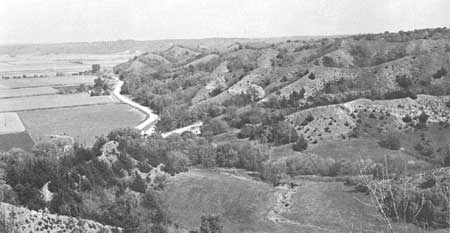
| Loess bluffs in western Iowa, seen here from Waubonsie State Park, offer exceptional prospects for a scenic road route. (IOWA STATE CONSERVATION COMMISSION.) |
PARK AND RELATED NEEDS
Emphasis needs to be placed on enlargement of existing parks; on acquisition and interpretation of historic and archeologic sites; on preservation of free-flowing streams of high scenic and natural value; and on utilizing more fully the recreation potential of the Mississippi and Missouri Rivers.
Existing State-administered recreation areas provide 29,298 acres, which are inadequate to meet the needs of the 2-3/4 million residents. Local areas provide an additional 12,421 acres. Potential areas of State significance identified in this plan total 20,463 acres, and locally significant areas amount to 8,520 acres. Even if all these potential acres were acquired and developed, they would not meet the requirements of the population by 1976.
|
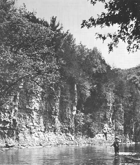
| The beautiful, free-flowing Upper Iowa River is a prime park and recreation resource in the State. (JIM SHERMAN, IOWA STATE CONSERVATION COMMISSION.) |
RECOMMENDATIONS
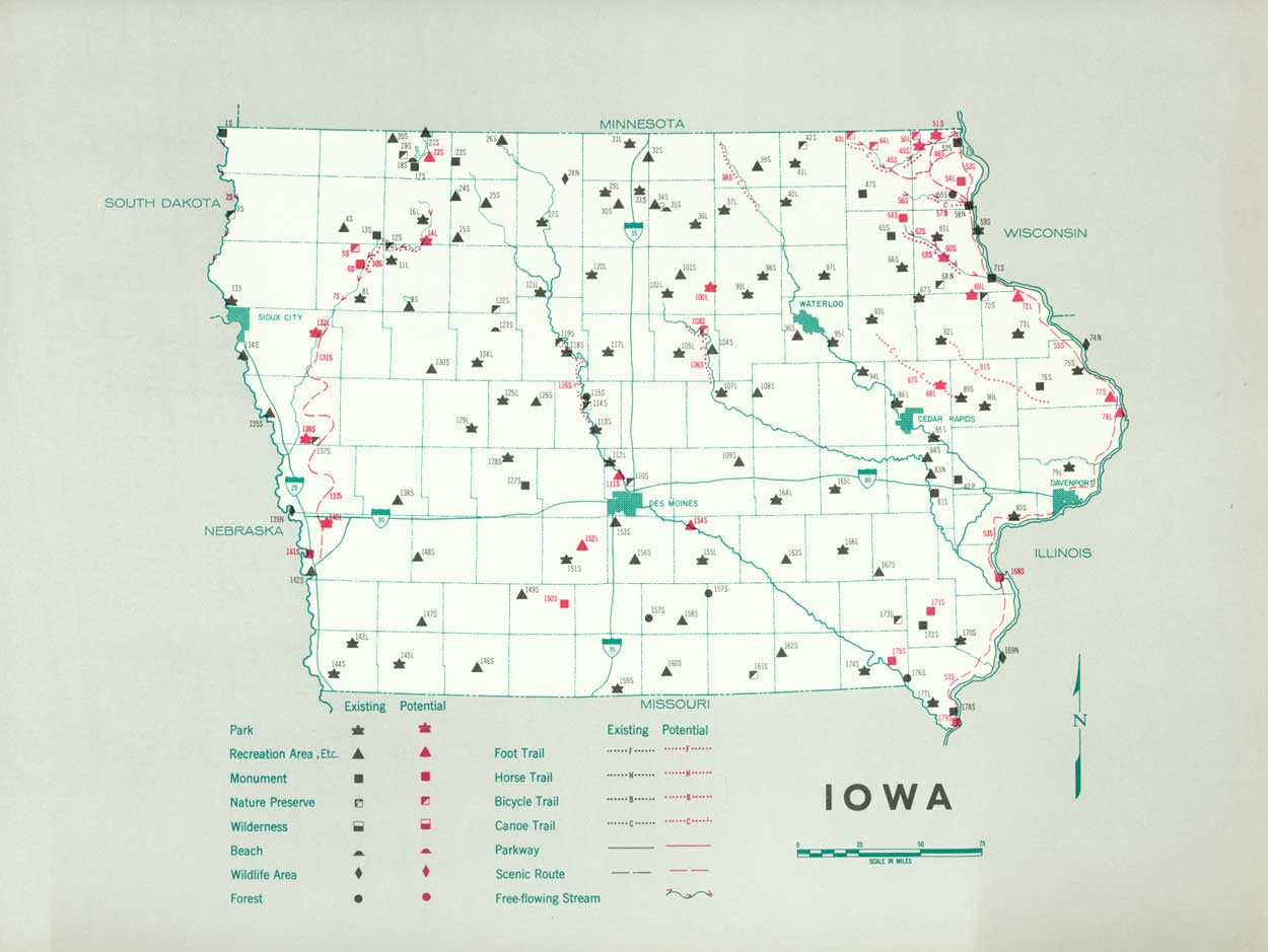
Existing recreation resources and many potential areas are shown on the accompanying tabulation and map. If the following recommendations are implemented by vigorous action on the part of the agencies concerned, it is believed that they can help substantially to provide needed outdoor recreation opportunities for public enjoyment and use.
STATE: Enlargement of the State park system to protect valuable resources by major additions to 19 existing areas and minor additions to 13 areas, plus acquisition of 2 parks, 3 monuments, and 2 nature preserves. Suggested for additional study are two parks and five monuments. Also establishment of three recreation areas and consideration of one additional area.
Designation and control of a system of canoe trails. Nine routes are suggested for initial study.
Preservation of the Upper Iowa and Yellow Rivers as free-flowing streams in their natural condition and further study to portions of two other rivers.
Development of the Great River Road and consideration of two other scenic roads.
LOCAL: Establishment of five parks and natural areas of local significance, which will preserve natural resources. Five additional parks and natural areas are suggested for further study. Also establishment of three recreation areas to meet recreation needs.
Supporting recommendations include—
1. Institution of a program of interpretation and other methods which will increase enjoyment of the parks by the users.
2. Study of the possibilities for horse, foot, and bicycle trails.
3. Development of plans, coordinated with adjoining States, to recognize the special opportunity provided by the Mississippi and Missouri Rivers as waterways for public enjoyment, including acquisition of areas and other access points, zoning or other controls, and related matters such as pollution abatement.
4. Consideration of various possibilities for interpreting and recognizing the Lewis and Clark, Mormon, and other important historic trails, and a program of informational historic markers.
5. Institution of a program of further development of existing waysides and addition of new waysides.
6. Provision of more land and developments on existing and proposed Federal reservoirs.
(Table omitted from online edition)
|
| (click on image for an enlargement in a new window) |
NEXT >>>
 Top
Top
|
|
Last Modified: Mon, Sep 6 2004 10:00:00 pm PDT
parks_america/iowa.htm