.gif)
Parks for America
MENU
![]() Findings and Recommendations
Findings and Recommendations
|
Parks for America
|

|
|
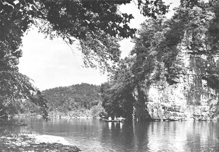
| Portions of the Current and Eleven Point Rivers in the Ozark region of Missouri, two of the Nation's finest free-flowing streams, have been proposed for national river status. (MASSIE, MISSOURI RESOURCES COMMISSION.) |
MISSOURI
MISSOURI, with the junction of the Missouri and Mississippi Rivers, was the gateway to the West. Its history dates back to the early French explorers.
In 1960 the State population was 4,319,813, a 9-percent increase from 1950. Sixty-seven percent of the people reside in urban areas The population density is 63 per square mile, ranging from 6 in Reynolds County in the southeast to 1,416 in St. Louis County and 12,296 in St. Louis City. Major metropolitan areas are St. Louis, Kansas City, Springfield, and St. Joseph. Projections indicate a population of 5 million by 1976.
The tourist industry ranks second in the State's economy. The estimate of tourist expenditures in 1960 was $607 million. The Ozark region and large reservoir impoundments offer potentialities for further development of the industry.
The recreation resources of the State are readily accessible to the large metropolitan areas of the Midwest.
The long spring and fall seasons are delightful, especially in the Ozarks, offering forested hills, clear spring-fed streams, semiwilderness experiences, and several major reservoir impoundments. The Mississippi and Missouri Rivers also are important in the recreation picture. There are many historic and archeologic sites manifesting the significance of Indian cultures and the State's role in the fur trade and westward expansion. The town of Sainte Genevieve, the Patee House in St. Joseph, Fort Osage, and Graham Cave possess exceptional value in commemorating the history of the United States and are eligible for Registered National Historic Landmark status.
|
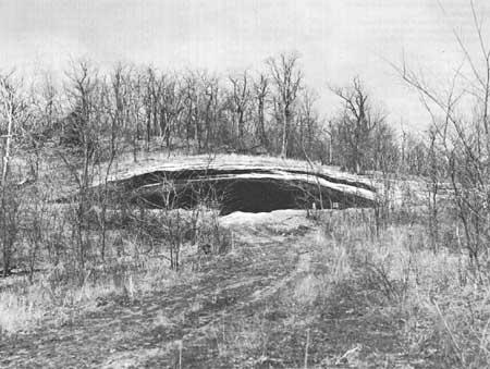
| More than 9,000 years ago, Indian hunters dwelled in Graham Cave, in a bluff above the Loutre River, Missouri. (UNIVERSITY OF MISSOURI.) |
EXISTING PUBLIC AREAS
NATIONAL: The National Park Service administers a national historic site of 83 acres and a national monument of 210 acres, with attendance of 94,899 in 1960. The Forest Service administers two national forests covering 1,352,421 acres in Missouri. The Bureau of Sport Fisheries and Wildlife administers three national wildlife refuges containing 39,449 acres. The Corps of Engineers operates three reservoirs totaling 118,447 acres, plus two others lying mostly in Arkansas.
STATE: The Missouri State Park Board administers 36 areas totaling 69,138 acres, with an attendance of 6,044,124 in 1960. The Missouri Conservation Commission administers 79 forests and wildlife areas of 344,728 acres, including the 245,267 acres in the 29 areas tabulated. The Missouri Highway Commission maintains 102 roadside parks.
LOCAL: Two major nonurban recreation areas of 4,093 acres are operated by local agencies.
QUASI-PUBLIC AND PRIVATE: There are 11 major quasi-public and private areas providing 8,506 acres for public use.
PRIVATE ENTERPRISE: Significant privately operated facilities and services are provided in the Ozarks, at reservoirs and along the Mississippi.
|
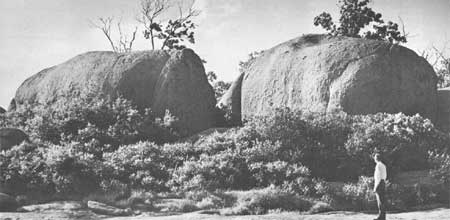
| Elephant Rocks, natural sculptures near Graniteville, Missouri. |
PARK AND RELATED NEEDS
The outstanding need is for day-use areas in proximity to urban areas, especially near Kansas City and Joplin. The State park system needs to be rounded out to include significant scientific and historic sites and a few outstanding natural areas. The extreme southeastern corner of the State lacks recreation opportunities. There is need for protection of free-flowing streams, for development of recreation water impoundments, and for development of scenic roads along the Mississippi and Missouri Rivers and in the Ozarks.
Existing State areas total 69,141 acres for over 4 million residents, and there are an additional 4,093 acres of nonurban local areas. Potential areas of State significance identified in this plan total 31,000 acres, and potential local areas identified total 81,720 acres.
|
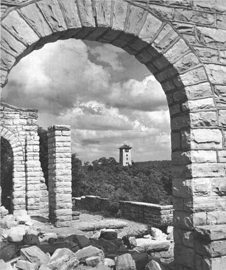
| Ha Ha Tonka, unfinished "Castle" atop Deer Leap Hill near Camdenton, Missouri. The 3,500-acre estate has State park potential. (MASSIE-MISSOURI COMMERCE.) |
RECOMMENDATIONS
Existing recreation resources and many potential areas are shown on the accompanying tabulation and map. The following recommendations are offered to help provide needed outdoor recreation opportunity. To be effective, they will need to be implemented by vigorous action on the part of agencies concerned.
NATIONAL: Establishment of Wilson's Creek National Battlefield and Ozark National Rivers.
Study of the feasibility and desirability of establishing Research Cave and Graham Cave National Monuments.
STATE: Action at the State level to conserve and use valuable recreation resources. Recommended are four parks and three monuments. Two additional parks are suggested for study.
Consideration of a system of scenic roads. One scenic road is recommended; three others are suggested for further study.
Preservation and proper development of remaining free-flowing streams. Two such streams are suggested.
Designation of a system of canoe (or john-boat) trails. Seven trails are suggested for initial consideration.
LOCAL: Expansion of local park systems and programs. Recommended are four parks, four recreation areas, and two nature preserves. Suggested for additional study are four parks, seven recreation areas, and one nature preserve.
Supporting recommendations include—
1. Additions to some existing areas to eliminate inholdings, to incorporate additional desirable features, to improve ease of administration, or to protect existing values by adjustment of boundaries.
2. Investigation of possibilities of providing better access to reservoirs and to major streams.
3. Acquisition and development of additional recreation areas by Jackson County.
4. Establishment of regional park and planning commissions by joint action of counties and States in the St. Louis area.
5. Formation of a park department in Greene County (Springfield).
6. Exploration of the possibility of orderly development of the Table Rock Reservoir and for the southeastern Ozarks in the vicinity of the proposed Ozark National Rivers.
7. Acquisition by a State agency of lands adjacent to metropolitan areas and suitable for recreation development, such lands to be held pending establishment of local agencies capable of providing for their proper development.
8. Consideration by the Highway Department of revising its wayside policy so as to acquire and develop wayside parks more actively.
9. Establishment of State controls on roadside advertising.
(Table omitted from online edition)

|
| (click on image for an enlargement in a new window) |
NEXT >>>
 Top
Top
|
|
Last Modified: Mon, Sep 6 2004 10:00:00 pm PDT
parks_america/missouri.htm