.gif)
Parks for America
MENU
![]() Findings and Recommendations
Findings and Recommendations
|
Parks for America
|

|
OHIO
SITUATED between the mountains of Pennsylvania and West Virginia on one side and the broad lands of Indiana on the other, Ohio has some of the topographic features of each.
|
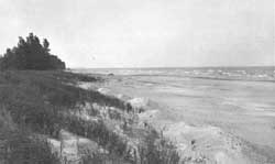
| Attractive portions of the Lake Erie shore, such as this reach near Sandusky Bay, Ohio, are recommended for State park purposes. |
The 1950 population increased 22.1 percent to 9,706,397 by 1960. With 73.4 percent of the people living in urban areas, the density averages 237 per square mile, ranging from 25 in Vinton County in the south-central section to 3,614 in Cuyahoga County, which includes Cleveland. There are 15 metropolitan areas of over 50,000.
The estimated value of the tourist industry in 1960 was $971 million, ranking it third behind manufacturing and agriculture. Areas of chronic economic distress are found in the south and southeastern counties and in the north-central portion along Lake Erie.
East-west travel on existing roads is good and will be improved with completion of Interstates 70 and 80. North-south travel has been difficult, but three planned interstates will improve accessibility to the southeastern section, which contains much of the recreation resource. Every major urban area will have access to at least one of these highways.
The unglaciated southeastern section presents the most diverse landscape, most of the forest area, and many swift-flowing streams. Lake Erie in the north presents a recreation resource near the State's most populous section. Although it is generally heavily developed by private interests, several sites suitable for public development remain. Portions of the shore line are important for resting and feeding of migratory waterfowl. Rivers and streams throughout the State are important for recreation, particularly the Ohio River with its navigation pools. Water impoundments are significant, since there are few natural lakes. The climate is varied enough to offer the usual summer outdoor pursuits varied with ice fishing and boating in winter.
Sites illustrating the prehistoric cultures that once flourished in Ohio have great educational value. The State is also rich in historic sites. The Fallen Timbers Battlefield is of exceptional value in commemorating the history of the United States.
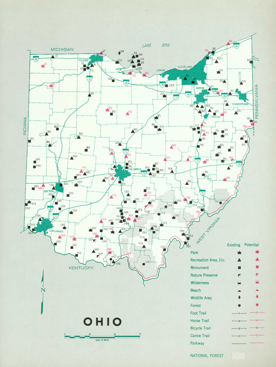
EXISTING PUBLIC AREAS
NATIONAL: The National Park Service administers 2 national monuments of 81 acres that had an attendance of 96,000 in 1960. The Corps of Engineers operates two reservoirs of 15,147 acres. There is one national forest of 113,000 acres administered by the Forest Service, and one national wildlife refuge of 82 acres administered by the Bureau of Sport Fisheries and Wildlife.
STATE: The Division of Parks administers 49 areas totaling 84,542 acres that received an attendance of 15,947,523 in 1960. The Division of Properties, Ohio Historical Society, operates 53 State memorials involving 4,195 acres. Other State agencies in the recreation field are: Department of Public Works, 2 areas, 1,330 acres; Division of Forests, 18 forests, 153,066 acres; Division of Wildlife, 64 fish and game management areas, 50,565 acres; Department of Highways, 277 roadside rests.
LOCAL: The Muskingum Watershed Conservancy District operates 9 recreation areas on 23,428 acres that had a 1960 attendance of 1,371,160. Major nonurban metropolitan and county parks total approximately 33,930 acres.
QUASI-PUBLIC AND PRIVATE: Three historic monuments are available to the public, as well as two nature preserves and a foot trail.
PRIVATE ENTERPRISE: In areas where population concentrations create pressing recreation needs, there have been attempts at providing privately owned day-use and overnight facilities ranging from picnic areas and campgrounds to marinas and summer cottages.
PARK AND RELATED NEEDS
Protection of those portions of the Lake Erie shoreline still in a reasonably natural condition is most pressing. Major streams, even those not free flowing, should be considered for protection. A program for parkways and scenic roads needs to be initiated. There is need for more day- and weekend-use areas to serve the State's metropolitan areas, also Wheeling and Huntington, W. Va., and Fort Wayne, Ind. Scarcity of natural lakes for water-oriented recreation emphasizes the importance of reservoirs, particularly those whose primary purpose is recreation.
Existing areas under State administration provide 113,887 acres for 9,706,397 residents, and local areas provide an additional 33,928 acres. Potential areas of State significance identified in this plan total 353,788 acres, and local ones another 1,310 acres. If all of these potential areas were acquired and developed, there still would remain a large unsatisfied need to serve the estimated 1976 population.
RECOMMENDATIONS
Existing recreation resources and many potential areas are shown on the accompanying tabulation and map. The following recommendations, if implemented by vigorous action on the part of the agencies concerned, may help to meet Ohio's outdoor recreation needs.
NATIONAL: Studies to determine the feasibility and desirability of establishing the Ohio River-Allegheny River Parkway.
STATE: Expansion of the system of State parks to preserve the remaining areas worthy of such action. Seven parks are recommended, as well as major additions to six existing parks. Seven additional parks are suggested.
Protection of three areas as nature preserves.
LOCAL: Broad expansion of most local park systems. Two new areas and a major addition to one existing area are recommended at this time.
Supporting recommendations include—
1. A comprehensive survey of historic and archeologic sites within the State with a view to the preservation and development of those found to possess sound educational and inspirational values.
2. Designation and proper development of systems of canoe trails and foot trails to provide for a more well-rounded park and recreation program.
3. Provision for control of pollution and consideration of flood-plain zoning to enhance streamside recreation.
4. Intensification of efforts to broaden local recreation systems and programs to accommodate intensive day use.
(Table omitted from online edition)
|
| (click on image for an enlargement in a new window) |
NEXT >>>
 Top
Top
|
|
Last Modified: Mon, Sep 6 2004 10:00:00 pm PDT
parks_america/ohio.htm