.gif)
Parks for America
MENU
![]() Findings and Recommendations
Findings and Recommendations
|
Parks for America
|

|
|
| A potential State recreation area, located on the Pine Ridge Indian Reservation, is Denby Lake, 11 miles east of Pine Ridge. |
SOUTH DAKOTA
SOUTH DAKOTA, a northern Great Plains State bisected by the Missouri River, offers excellent recreational opportunities, particularly for hunting and fishing.
The State population increased 4 percent in the decade 1950-60 to 680,514, with 39 percent urban. Projections indicate the population may be 796,000 by 1976. The average density in 1960 was 8.9 persons per square mile.
Tourism ranks third in the State's economy. An estimated 4 million out-of-State visitors spent $106 million in South Dakota in 1960. The Black Hills and Badlands area produced the major portion of the tourist income, $79.5 million.
East-west highways channel eastern out-of-State travel to the Black Hills and west to major targets such as Yellowstone National Park.
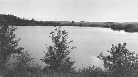
The State has a variety of surface features—the Black Hills and Badlands in the west, the Missouri River in the center, and the pothole lakes in the north east. Typical Great Plains weather prevails: hot summers and long, cold winters. The Black Hills, nationally famous for Mount Rushmore and Custer State Park, offer exceptional opportunities to see buffalo and elk. Waterfowl are plentiful, and the State is noted for its Chinese ringneck pheasants. A significant recreation resource is the development of the main stem of the Missouri River which will provide four major reservoirs.
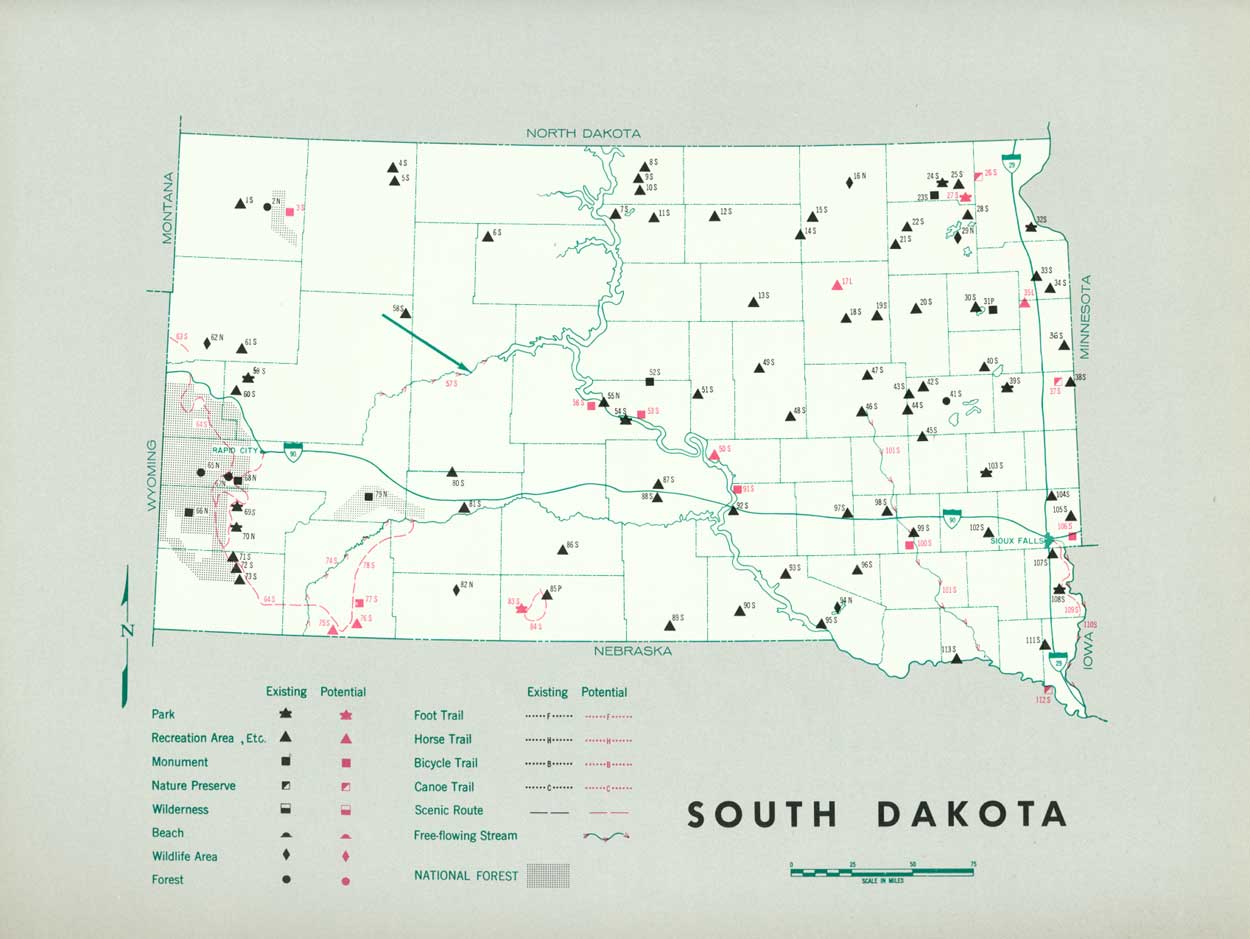
EXISTING PUBLIC AREAS
NATIONAL: The National Park Service administers a national park, a national memorial, and two national monuments totaling 129,360 acres. The 1960 attendance was 2,858,700. The Forest Service administers 2 national forests of 1,120,813 acres in which there are 65 developed recreation areas on 700 acres and 1 wildlife preserve of 46,000 acres. The Bureau of Sport Fisheries and Wildlife administers five national wildlife refuges totaling 19,169 acres. The Corps of Engineers administers five reservoirs which have 222,122 acres of land and 582,815 acres of water; except for Oahe Reservoir, recreation use is administered by other agencies.
STATE: The South Dakota Game, Fish and Parks Department administers 98 parks and recreation areas totaling 88,812 acres. One park—Custer State Park—contains 72,000 acres; 1960 attendance was 3,645,190. The State also has 50 waysides. The Fish and Game Division administers 66,454 acres in 207 hunting and fishing areas. The South Dakota State Historical Society has placed 340 State markers and monuments throughout the State.
PRIVATE ENTERPRISE: Private enterprise provides a wide variety of recreation opportunities. Resorts are found in the pothole lake country and the Black Hills, where there are three privately owned campgrounds.
PARK AND RELATED NEEDS
Because South Dakota's major recreation resources are in the extreme western portion of the State, there exists a geographic imbalance in the existing State park system. There is a need for more park facilities in the eastern quarter of the State, near the major portion of the State's population.
Existing State areas contain 88,812 acres. No existing local areas have been identified. Potential State areas identified total 15,050 acres. Additional acreage will be needed to adequately serve the projected population and expected increase in visitors. The 220 acres in identified potential local areas are far short of the 1976 needs. The wayside system should receive some attention in terms of spacing. Interstate routes 25 and 90 will need off-highway waysides and camping facilities.
|
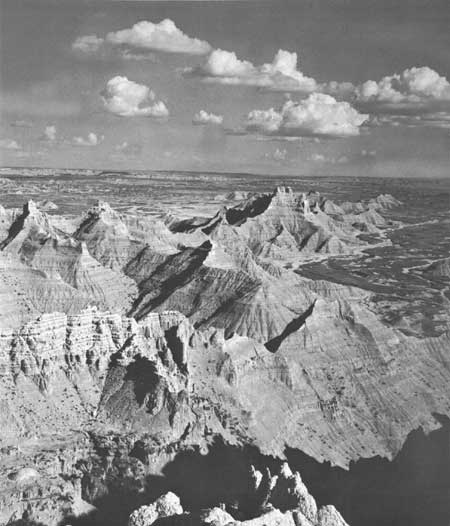
| Some of the most spectacular Badlands formations occur in the Sheep Mountain area, adjacent to Badlands National Monument, South Dakota, and suggested to possible addition to the monument. |
RECOMMENDATIONS
Existing recreation resources and many potential areas are shown on the accompanying tabulation and map. The following recommendations are offered to help meet South Dakota's outdoor recreation needs.
STATE: Protection of valuable resources and provision of a balanced park system by the addition of one park, seven monuments, three nature preserves, and three recreation areas. Further study of one potential park area and additions to six existing parks. Designation and protection for five scenic roads and three free-flowing streams and further study of a scenic route from the Badlands to the Black Hills.
LOCAL: Two local recreation areas are listed for consideration.
Supporting recommendations include—
1. Cooperative study to determine desirability and feasibility of a Lewis and Clark historic tourway coordinated with other States and appropriate agencies.
2. Acquisition by the State of suitable pothole lake shore land, to be held in a recreation reserve.
3. Reconstruction of Fort Pierre Chateau site as a major interpretive center on the Lewis and Clark Trail.
4. Archeological artifacts salvaged from sites that will be affected by the Missouri River development should be incorporated in an interpretive center coupled with in situ exhibits at Crow Creek Village site.
5. Provision of adequate acreage for recreation development of Oahe, Gavins Point, Fort Randall, and Big Bend Reservoirs.
(Table omitted from online edition)
|
| (click on image for an enlargement in a new window) |
NEXT >>>
 Top
Top
|
|
Last Modified: Mon, Sep 6 2004 10:00:00 pm PDT
parks_america/south_dakota.htm