.gif)
Parks for America
MENU
![]() Findings and Recommendations
Findings and Recommendations
|
Parks for America
|

|
|
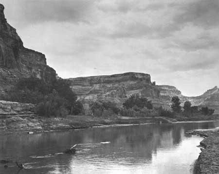
| The San Rafael River area in Utah, a little-known region of magnificent canyons and mesas, could be easily adapted to park use. |
UTAH
UTAH has a unique variety of mountains, rivers, canyons, forests, and deserts offering great opportunities for year-round recreation.
The State's population increased 29 percent between 1950 and 1960 to 890,627, and projections indicate it may reach 1,297,000 by 1976. The urban population increased 48 percent in the last decade, making it 75 percent of the total population. Density varies from less than 1 per square mile in large remote areas to 501 persons per square mile in Salt Lake City.
The recreation and tourist industry is a major part of Utah's economy, providing $200 million annually. Income from the tourist industry should rise sharply due to expanding recreation travel and the State's growing attention to the undeveloped recreation potential in the southeastern canyon country and its Wasatch Range area. Manufacturing and mining industries lead recreation and tourism in the State's economy.
The automobile is the most common method of transportation to park and recreation areas. Federal and State highways give good access to most parts of the State.
The mountain, valley, and desert complex causes a wide difference in climatic conditions and makes possible year-round variety of day use and vacation recreation activities. In the north, the Wasatch and Uinta Mountains offer one of the longest winter sports seasons in the nation. In the southern valleys and canyons, other outdoor activities may be enjoyed 9 months of the year. The Colorado, San Juan, and Green Rivers are national attractions for boating and general recreation. Great Salt Lake adds to the number of unusual attractions. Southern Utah has the most colorful and unusual rock formations to be found in the United States.
Numerous sites of early Indian occupation plus sites associated with Mormon settlement add to the wealth of recreation resources. Danger Cave and Emigration Canyon possess exceptional values in commemorating the history of the United States.
|
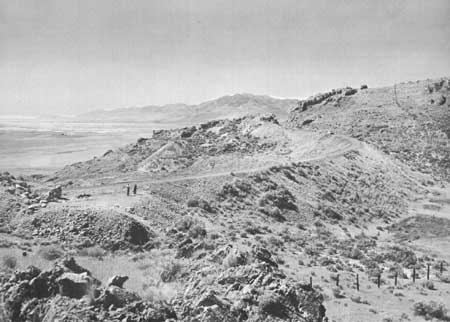
| Railroad builders raced each other up these slopes to link East to West by transcontinental rail at Promontory Summit. This area in Utah near Great Salt Lake could comprise an enlarged Golden Spike National Historic Site in the National Park System. |
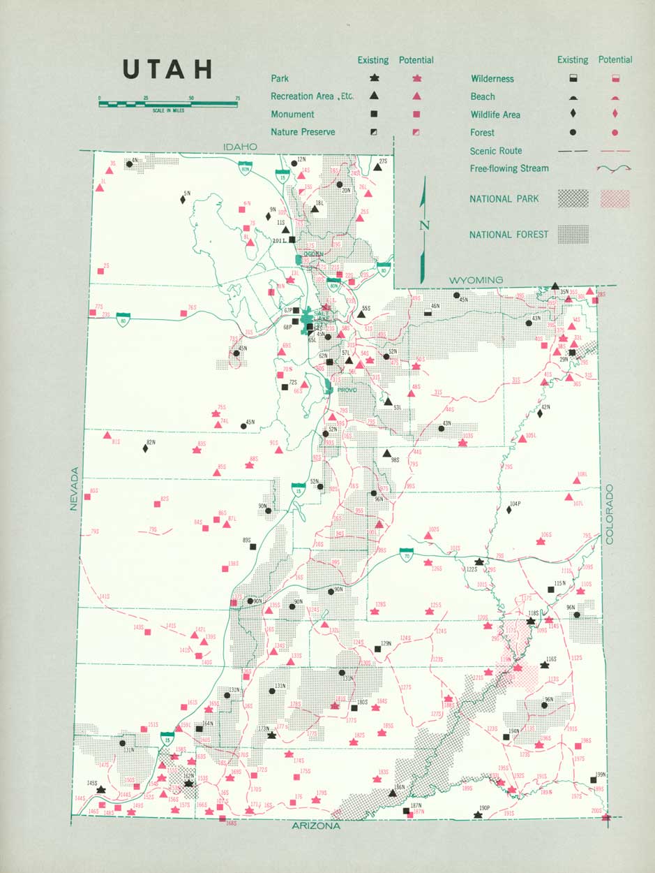
EXISTING PUBLIC AREAS
NATIONAL: The National Park Service administers two national parks, eight national monuments, and two national recreation areas with 1,659,552 acres in Utah. The 1960 attendance was 2,526,700. There are 9 national forests having a total of 6,853,372 acres and including 1 wilderness area and 178 recreation development sites, administered by the Forest Service. The Fish and Wildlife Service administers four wildlife refuges with 84,891 acres.
STATE: The State Park Department manages 4 parks, 4 recreation areas, and 4 monuments that contain 20,280 acres and had an attendance of 524,550 in 1960. The State Road Commission maintains 16 roadside rest areas and 40 historical markers.
LOCAL: There are two major local nonurban recreation areas and one nature preserve that serve the Salt Lake City-Provo area, and one recreation area serving Ogden-Logan. Golden Spike National Historic Site is in county ownership.
PRIVATE ENTERPRISE: Private enterprise provides substantial resort, winter sports, and tourist accommodation facilities in Utah. The Ouray Indian Reservation has one park, three recreation sites, and one wilderness area.
PARK AND RELATED NEEDS
Additional areas are needed to provide day and weekend facilities for the Ogden-Salt Lake City-Provo region. There is also need for further integration of State and Federal programs for the protection and development of significant recreation resources. Potential State and local areas identified in this plan, totaling 1,395,330 acres, would go far toward meeting these needs.
|
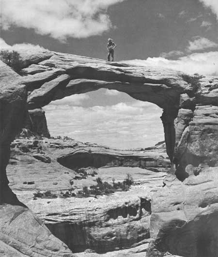
| Spectacular formations like this recently discovered arch still await discovery and appreciation in Utah's wild Canyonlands country, proposed as a national park. |
RECOMMENDATIONS
Existing recreation resources and many potential areas are shown on the accompanying tabulation and map. The following recommendations are made to help provide needed outdoor recreation opportunities for public enjoyment and use.
NATIONAL: Establishment of Canyonlands National Park in southeastern Utah and study of the proposal for the preservation of an area of unusual scientific interest at Great Salt Lake. Explore the national park potentialities of some 300,000 acres surrounding Rainbow Bridge National Monument. Establishment of the Golden Spike National Historic Site, as an enlarged, Federal area.
STATE: Enlargement of the State park system to protect valuable resources and provide additional recreation opportunities by the addition of 29 parks, 14 recreation areas, 5 scientific monuments, 20 historic monuments, and 1 nature preserve. Further study is also suggested for six parks, nine recreation areas, one scientific monument, and one historic monument. Designation and protection of 41 scenic roads and 4 free-flowing streams.
LOCAL: Establishment of 3 major local parks and further study of 15 local recreation areas.
Supporting recommendations include—
1. Establishment of cross-country hiking and riding trails along the Wasatch and Uinta Mountain Ranges and the Green River.
2. Field investigation of the Henry Mountain region to determine the recreation values of the resources of that largely undeveloped area.
(Table omitted from online edition)
|
| (click on image for an enlargement in a new window) |
NEXT >>>
 Top
Top
|
|
Last Modified: Mon, Sep 6 2004 10:00:00 pm PDT
parks_america/utah.htm