.gif)
Parks for America
MENU
![]() Findings and Recommendations
Findings and Recommendations
|
Parks for America
|

|

|
| The scenic, pastoral Shenandoah River, a favorite bass stream, rippling and gliding under the Blue Ridge and Massanutten Mountains, merits designation as a canoe trail. |
VIRGINIA
IN VIRGINIA the mountains, seacoast, and important cultural contributions combine to produce fine and diversified outdoor recreation resources. A good number are in public or quasi-public ownership; some are still largely untapped. Many opportunities have already been lost.
The population increased 19 percent in the last decade to 3,966,949 in 1960. The percentage of increase about equaled the national average. Projections indicate 5,385,000 by 1976. Much of the urban 55.6 percent is concentrated in the tidewater region and along the eastern fringe of the piedmont. The major metropolitan areas are Richmond, Roanoke, the Hampton Roads area, and the suburbs of Washington, D.C.
Outdoor recreation plays an important part in the State's economy. The tourist industry, second only to manufacturing in 1960, had an estimated value of $725 million. Many local and national tourist attractions are owned and managed by private enterprise and quasi-public organizations.
The highway system provides good access to most of the attractive recreation regions. This is less true of the coast, where deeply serrated shorelines make direct access difficult. The interstate routing will bring the mountains nearer to large urban populations, and the Chesapeake Bay Bridge-Tunnel, when completed, is expected to increase through travel.
Virginia has three distinct regions, tidewater, piedmont, and mountain, providing wonderfully varied opportunities for outdoor recreation. The State is rich in historic sites dating from colonial, Revolutionary, and Civil War times. Twenty-three sites not in the National Park System possess exceptional value in commemorating the history of the United States.
Sectional variations in climate permit a long out door recreation season and a wide range of activities; and varied topography, from seacoast to 3,000-foot mountains, encourages changes of activities.
Despite many miles of coastline, most of the seashore opportunities have long since been foreclosed. Much of this shoreline fronts on Chesapeake Bay and the large estuaries of the Potomac, Rappahannock, York, and James Rivers, where pollution is a serious problem.
Enjoyment of the natural and historic scene, along with swimming and other water-related activities, are prime interests in this State. Fresh and salt-water fishing is popular and now being improved.
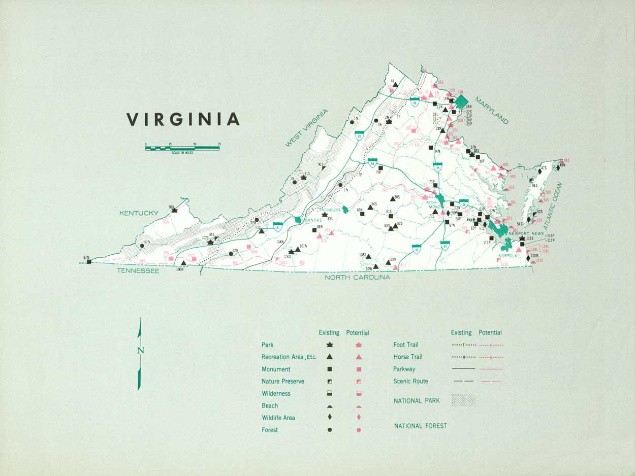
EXISTING PUBLIC AREAS
NATIONAL: The National Park Service administers 14 areas, 2 of which are partly in adjacent States. They contain 258,227 acres and had an attendance of 9,700,000 in 1960. The Tennessee Valley Authority operates one reservoir (partly in Tennessee) of 7,580 water-acres. The Corps of Engineers operates two reservoirs (one partly in North Carolina) with 56,100 water-acres. The Forest Service has 15 recreation areas on about 500 acres in 2 national forests that have a total of 1,446,132 acres. The Bureau of Sport Fisheries and Wildlife manages 14,648 acres in three wildlife refuges.
STATE: The Breaks Interstate Park Commission operates 1 park (partly in Kentucky) of 1,518 acres that had an attendance of 21,000 in 1960. The Virginia Division of Parks administers five parks, seven recreation areas, four natural areas, and two historical areas totaling 29,394 acres. The 1960 attendance was 916,165. The Commission of Game and Inland Fisheries operates 13 fishing reservoirs, 31 access areas, 3 wildlife refuges, and 20 public hunting areas. The Division of Forestry administers 3,975 acres in four forests. The Department of Highways operates 10 waysides which provide water and sanitation facilities and 34 roadside picnic areas. They contain 503 acres.
LOCAL: There are six major nonurban parks and recreation areas containing 2,760 acres.
QUASI-PUBLIC AND PRIVATE: Thirteen outstanding historic sites totaling 3,868 acres and the 460-mile Appalachian Trail are operated by quasi-public and private organizations for public use.
PRIVATE ENTERPRISE: A significant role is played by private enterprise—seashore resorts, beaches, boating facilities, mountain resorts, caverns, and other geologic features. Private power company reservoirs contribute recreation opportunities.
PARK AND RELATED NEEDS
The fast-growing population, coupled with tremendous numbers of out-of-State visitors, accents the urgency to conserve and develop remaining resources for public use, particularly in the more populous sections. Existing recreation facilities are not in balance by type and distribution with the demand. The few remaining seashore opportunities call for most prompt action. Camping areas in the tidewater section are lacking.
The State park system needs additional and diversified areas. Even more pressing is the situation at local and metropolitan levels where little has been done. In addition to parks and related areas as such, much should be done through zoning or other appropriate State or local action to preserve the attractiveness of scenic routes, streams, and the countryside in general.
For the present population of more than 4 million (including one-half of the District of Columbia population), existing State recreation areas now provide only 31,812 acres, local areas an additional 3,210. Even if ideally distributed, this is but a fraction of the need. Potential areas identified in this plan total 158,905 acres judged of State significance and 44,030, local. This still might be short of the desirable picture, even if it all could be acquired. By 1976 the demand will be greater.

|
| Great Falls rumble down a wild Potomac gorge only ten miles from the National Capitol. To complement parkland across the river, the Virginia shore of this spectacular natural area also merits park status. |
RECOMMENDATIONS
Existing recreation resources and many potential areas are shown on the accompanying tabulation and map. If the following recommendations are implemented by vigorous action on the part of the agencies concerned, they can do much, it is felt, to help provide needed outdoor recreation opportunities for public enjoyment and use.
NATIONAL: Establishment of Great Falls Park as a unit of the National Capital Park System and two extensions to the George Washington Memorial Parkway. Study the feasibility of an Allegheny National Parkway extending from Hagerstown, Md., to Cumberland Gap National Historical Park. Further study of suitability and feasibility for an Appalachian Parkway.
STATE: Expansion of the State park system to preserve valuable resources by addition of two parks and two natural areas and major additions to two existing parks. Further study of 18 suggested areas and 1 parkway. Designation and protection for three scenic roads and two canoe trails.
LOCAL: Establishment of 10 parks and recreation areas and further study of 15 suggested areas.
Supporting recommendations include—
1. An adequate system of waysides, including the State's plan for 42 Interstate Highway rest areas, improvement of existing waysides, and consideration of a related program of interpretive devices.
2. Consideration for conversion of Conway Robinson Memorial Forest to recreation use.
3. Cooperative planning to take full advantage of recreation potential on 17 proposed Federal reservoirs—this to include consideration of lands around proposed J. W. Flannagan Reservoir for addition to Breaks Interstate Park.
4. Interstate cooperation toward preservation of Dismal Swamp and the Outer Banks.
(Table omitted from online edition)
|
| (click on image for an enlargement in a new window) |
NEXT >>>
 Top
Top
|
|
Last Modified: Mon, Sep 6 2004 10:00:00 pm PDT
parks_america/virginia.htm