|
Pea Ridge National Military Park Arkansas |
|
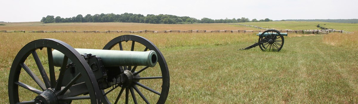 NPS photo | |
The Battle That Saved Missouri for the Union
Keeping Missouri in the Union was a prime objective of the Federal government during the first year of the Civil War. It was the reason that the Battle of Wilson's Creek was fought near Springfield, Mo., in August 1861, and it was one of the reasons for the battle at Pea Ridge in March 1862.
The Pea Ridge Campaign began on Christmas Day, 1861, with the appointment of Brig. Gen. Samuel R. Curtis to command the Federal Southwestern District of Missouri. Curtis's main objective was to drive the Confederate and pro-Confederate forces from the state. By mid-February 1862 he and his troops had chased their main opponents, Maj. Gen. Sterling Price and the pro-Confederate Missouri State Guard, into Arkansas.
In the Boston Mountains south of Fayetteville, Price joined forces with Brig. Gen. Ben McCulloch's Confederates. There on March 4 Maj. Gen. Earl Van Dorn took command of this combined 16,000-man army and led it north, intending to strike into Missouri and capture 5t. Louis. But Curtis's 10,500 Federals were dug in across his path on the bluffs above Little Sugar Creek, not far from Elkhorn Tavern and nearby Elkhorn Mountain (part of the larger Pea Ridge plateau).
Van Dorn knew that a frontal assault against Curtis's troops would be suicidal, so he swung north to come in behind them. He planned to strike at dawn on March 7, but his troops, hungry, cold, and weary from a difficult three-day march, arrived hours behind schedule. McCulloch's troops fell so far behind that Van Dorn decided to temporarily divide his army. He ordered McCulloch around the west end of Elkhorn Mountain, then to turn east along Ford Road to rejoin Price's troops near Elkhorn Tavern. These delays gave Curtis time to face about and prepare for the attack.
As McCulloch's troops, including two regiments of Cherokee Indians under Brig. Gen. Albert Pike, were engaged in this maneuver, they ran into intensive fire near Leetown that killed McCulloch and Brig. Gen. James McIntosh and led to the capture of the ranking colonel. With their command structure practically destroyed, McCulloch's men scattered from the field.
Attacking east of Elkhorn Mountain, Van Dorn and Price fared better. Price's Missourians slowly but steadily pushed the Federals back until, at nightfall, they held Elkhorn Tavern and the crucial Telegraph and Huntsville roads. During the night the survivors of McCulloch's Leetown fight joined them.
On the morning of March 8 Curtis counterattacked in the tavern area. A two-hour artillery barrage crippled the Confederate line and a concerted infantry attack broke their defenses. Realizing that his ammunition was running low, Van Dorn ordered his troops to withdraw. The battle of Pea Ridge was over and most of the Union and Confederate troops moved east of the Mississippi to fight in other campaigns. Missouri remained in the Union and politically neutral throughout the war, although it provided men and supplies to both sides.
The Commanders
Brig. Gen. Albert Pike commanded the Confederate Indians who fought at Pea Ridge. Maj. Gen. Earl Van Dorn was not impressed by their performance and refused to acknowledge Pike in his official report. Maj. Gen. Sterling Price and Brig. Gen. Ben McCulloch had teamed up once before, at Wilson's Creek. Their relationship was stormy, mainly because of McCulloch's indifference to Missouri's fate and his low opinion of Price's State Guard. Union commander Brig. Gen. Samuel R. Curtis won promotion for his performance at Pea Ridge. 5o did Curtis' second in command, German-born Brig. Gen. Franz Sigel, who saw the Federal victory at Pea Ridge as sweet revenge for his earlier defeat at Wilson's Creek at the hands of Price and McCulloch.
Touring Pea Ridge Battlefield
Stop first at the visitor center, which contains a theater, bookstore, and small museum. From the parking area at the visitor center, follow the arrows to Telegraph Road. This road was built in 1838, linking Springfield, Mo., and Fort Smith, Ark. Turn left on Telegraph Road and proceed to tour stop 1.
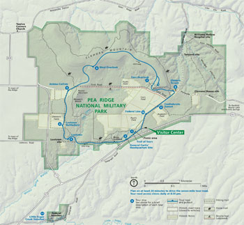 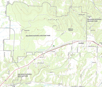 (click for larger maps) |
1 Trail of Tears The shallow depressions in front of you are remnants of the original Telegraph Road traveled by thousands of Cherokees and other American Indians in the winter of 1838-39 during their forced removal from their homelands. It was then called Wire Road because of the telegraph lines that lined the road and linked the nation. It was the route of the Butterfield Overland Stage line from 1857-61. Both armies used the road during the Pea Ridge Campaign.
2 General Curtis' Headquarters Site The Union commandeL Samuel R. Curtis, located his headquarters in this vicinity just before the battle. Curtis believed that any Confederate attack would come two miles south of here against his fortified line along the bluffs overlooking Little Sugar Creek. From this spot Curtis orchestrated the movements of his army.
3 Leetown This small village stood a short distance southwest of the parking lot. During the battle the wounded of both sides were brought here, where buildings and tents served as hospitals. All visible evidence of the village is gone.
4 Leetown Battlefield The Confederate attack through the woods north of this field and across the tour road to the east failed to defeat the Federals deployed along the south fence line. Two Confederate generals, Ben McCulloch and James McIntosh, were killed near the north boundaries of this field.
5 Armies Collide Pea Ridge was the only major Civil War battle in which Indian troops participated. Two regiments of Cherokees, about 1,000 men, fought for the Confederate army and routed two companies of Union cavalry. Union cannon fire eventually forced them to take cover in the woods. The Cherokee regiments were held in reserve throughout the remainder of the battle.
6 West Overlook From here the Boston Mountains are visible on the southern horizon. Bentonville, Ark., from which the Confederates advanced to Pea Ridge, is 14 miles to the west.
7 East Overlook Here, about 150 yards down the path, is the best view of the battlefield in the park. Wayside exhibits in the shelter explain the fighting that took place in the fields below.
8 Elkhorn Tavern The tavern, described as a place of "abundant good cheer" served travelers on the Telegraph Road before the war came to Arkansas. General Curtis used the tavern as part of his supply base until Confederates captured and occupied it early in the afternoon of March 7. They turned it into a field hospital caring for both Union and Confederate wounded. Union troops retook the tavern on March 8 after routing the Confederate forces from the field. The Federals used the tavern as a military telegraph station until Confederate guerrillas burned it in 1853. The present building is a reconstruction.
9 Confederate Sunset At dusk on March 7, Confederates charged across this field in an attempt to smash the regrouped Union troops. Devastating musket and artillery fire drove the Confederates back into the woods. That night both sides regrouped for the next day's battle. The guns in this field mark the battle lines of the morning of March 8.
10 Federal Line Union artillery deployed here on the morning of March 8. Their fire forced the Confederates to withdraw from the tavern area. The Federal line extended from present-day U.S. 52 to the south to beyond the bare open hill to the northwest.
11 Little Sugar Creek Trenches The time-eroded Federal trenches still exist on the bluff above Little Sugar Creek, 0.6 mile from U.S. 62.
About Your Visit
The park, 10 miles northeast of Rogers, Ark., is open 8 am to 5 pm daily except Thanksgiving, December 25, and January 1. The tour road closes at 4:30 pm. The park may close for hazardous ice or snow conditions. A picnic area is at tour stop 1. No camping is permitted in the park; you can camp at Beaver Lake, 10 miles away.
Regulations Hunting, disturbing wildlife, and removing relics are prohibited. So are roller skating, roller blading, skate boarding, and kite flying and all competitive sports games like football, soccer, volleyball, and softball. Pets must be leashed. Cars must stay on the tour road. Service animals welcome.
Firearms Firearms are not allowed in federal facilities. For firearms regulations ask at the visitor center or check the park website.
Safety Please exercise caution. Poisonous plants are common, and rattlesnakes and copperheads live here. Do not climb on cannon, monuments, fences, bluffs, or trees. Stay alert to weather conditions.
Source: NPS Brochure (2012)
|
Establishment Pea Ridge National Military Park — July 20, 1956 |
For More Information Please Visit The  OFFICIAL NPS WEBSITE |
Documents
An Administrative History: Pea Ridge National Military Park (Christopher J. Huggard, c1997)
Aquatic Invertebrate Monitoring at Pea Ridge National Military Park, 2009-2010 NPS Natural Resource Data Series NPS/HTLN/NRDS-2012/240 (Janice A. Hinsey and David E. Bowles, February 2012)
Bird Monitoring at Ridge National Military Park, Arkansas: 2008 Status Report NPS Natural Resource Technical Report NPS/HTLN/NRTR-2009/194 (David G. Peitz, April 2009)
Bird Monitoring at Ridge National Military Park, Arkansas: Status Report NPS Natural Resource Technical Report NPS/HTLN/NRTR-2013/725 (David G. Peitz, April 2013)
Bird Monitoring at Pea Ridge National Military Park, Arkansas: Status Report NPS Natural Resource Data Series NPS/HTLN/NRDS-2017/1088 (David G. Peitz, March 2017)
Bird Monitoring at Ridge National Military Park, Arkansas: Status Report 2008-2021 NPS Natural Resource Report NPS/HTLN/NRR-2022/2445 (David G. Peitz, September 2022)
Cultural Landscape Report and Environmental Assessment, Pea Ridge National Military Park (September 2014)
Fish Community Monitoring at Pea Ridge National Military Park: 2009 Report NPS Natural Resource Data Series NPS/HTLN/NRDS-2011/217 (Hope R. Dodd, Janice A. Hinsey and Samantha K. Mueller, December 2011)
Forest Community Monitoring Baseline Report, Ridge National Military Park NPS Natural Resource Technical Report NPS/HTLN/NRTR-2008/082 (Kevin James, February 2008)
Foundation Document, Pea Ridge National Military Park, Arkansas (November 2016)
Foundation Document Overview, Pea Ridge National Military Park, Arkansas (January 2016)
H.R. 8265 — A Bill to establish the Peel National Park at the Pea Ridge battle field in Benton County, Arkansas 68th Congress, 1st Session (March 27, 1924)
Invasive Exotic Plant Monitoring at Ridge National Military Park: Year 1 (2006) NPS Natural Resource Technical Report NPS/HTLN/NRTR-2007/019 (Craig C. Young, J. Tyler Cribbs, Jennifer L. Haack and Holly J. Etheridge, March 2007)
Junior Ranger Activity Book (Ages 4-9), Pea Ridge National Military Park (2013; for reference purposes only)
Junior Ranger Activity Book (Ages 10-18), Pea Ridge National Military Park (2013; for reference purposes only)
National Register of Historic Places Nomination Form
Pea Ridge Battlefield (Jane E. Scott and Dwight T. Pitcaithley, June 1979)
Natural Resource Condition Assessment, Pea Ridge National Military Park NPS Natural Resource Report NPS/HTLN/NRR-2011/426 (Gust D. Annis, Michael D. DeBacker, David D. Diamon, Lee F. Elliott, Aaron J. Garringer, Phillip A. Hanberry, Kevin M. James, Ronnie D. Lee, Michael E. Morey and Dyanna L. Pursell, July 2011)
Report on Sullys Hill Park, Casa Grande Ruin; the Muir Woods, Petrified Forest, and Other National Monuments, Including List of Bird Reserves: 1915 (HTML edition) (Secretary of the Interior, 1914)
Report on Wind Cave National Park, Sullys Hill Park, Casa Grande Ruin, Muir Woods, Petrified Forest, and Other National Monuments, Including List of Bird Reserves: 1913 (HTML edition) (Secretary of the Interior, 1914)
Resources Management Plan - Pea Ridge National Military Park (April 1976)
The Battle of Pea Ridge 1862 Pea Ridge Military Park Centennial Committee, 1963)
"The Battle Raged...With Terrible Fury:" Battlefield Archeology of Pea Ridge National Military Park NPS Midwest Archeological Center Technical Report No. 112 (Carl G. Carlson-Drexler, Douglas D. Scott and Harold Roeker, 2008)
The Fishes of Pea Ridge National Military Park, Arkansas, 2003 USGS Scientific Investigations Report 2005-5129 (B.G. Justus and James C. Petersen, 2005)
Trail Master Plan/Environmental Assessment, Pea Ridge National Military Park (November 2017)
Vegetation Classification and Mapping of Ridge National Military Park: Project Report NPS Natural Resource Report NPS/PERI/NRR-2013/649 (David D. Diamon, Lee F. Elliott, Michael D. DeBacker, Kevin M. James, Dyanna L. Pursell and Alicia Struckoff, April 2013)
"When the War Come Up": Historic Resource Study, Pea Ridge National Military Park, Arkansas (Theodore Catton, June 2024)
White-tailed Deer Monitoring at Ridge National Military Park, Arkansas: 2005-2006 Status Report NPS Natural Resource Technical Report NPS/HTLN/NRTR-2006/015 (David G. Peitz, May 2006)
White-tailed Deer Monitoring at Ridge National Military Park, Arkansas: 2007 Status Report NPS Natural Resource Technical Report NPS/HTLN/NRTR-2007/026 (J. Tyler Cribbs and David G. Peitz, March 2007)
White-tailed Deer Monitoring at Ridge National Military Park, Arkansas: 2008 Status Report NPS Natural Resource Technical Report NPS/HTLN/NRTR-2008/104 (J. Tyler Cribbs and David G. Peitz, April 2008)
peri/index.htm
Last Updated: 01-Jan-2025