|
Rainbow Bridge
A Bridge Between Cultures: An Administrative History of Rainbow Bridge National Monument |

|
CHAPTER 2:
Life Before the Monument: Human Habitation at Rainbow Bridge and Its Environs
Long before Euro-American populations occupied the Southwest, enormous numbers of Native American peoples inhabited the region. The most populous group is known today as the Navajo Nation. Theories vary as to how Native Americans, including the Navajo, came to live in the American Southwest. While some archeologists and linguists have suggested that Native Americans migrated into the region from elsewhere, the Navajo Nation contends that Navajos emerged in the Southwest. [18] To be sure, the structure of development and the patterns along which culture evolved in the Southwest is still a subject of intense debate. To better understand the controversies and conflicts that colored Rainbow Bridge NM during the 20th century, it is important to examine the patterns of population development in the area. This chapter details how various Native American and Euro-American groups came to the region surrounding Rainbow Bridge and the conflicts and compromises that marked that influx. This information is critical to understanding the dynamics of the region's contemporary cultural disputes and the National Park Service's attempts to solve some of those disputes and to generate solutions.
There are two sets of data that detail human history at Rainbow Bridge. The first is commonly referred to as "written records" or scientific data. It is based on the many 20th century archeological expeditions that explored the region. The second, known as "oral tradition," or ethnographic data, is based on the ethnohistorical data collected by contemporary cultural historians and ethnographers. Unfortunately for contemporary readers, historians have barely tapped the vast reserve of oral history available in region. The ethnohistorical set of facts makes tacit use of archeological data but never at the expense of undermining a culture's history of itself. In other words, the ethnohistorical record never takes a backseat to the archeological record. At various points the archeological data coincides with the ethnohistorical data; at other times they do not. This administrative history makes no attempt to validate or discredit the stories told by either set of records. The focus is on the relative validity of those facts to their informants. The Navajo Tribe, while conducting contemporary archeological research, is not swayed from the ontological truth of its own oral tradition and history. Nor is any non-Navajo archeologist working under the penumbra of contemporary science dissuaded from the facts as they are presented through radio carbon dating and comparative site analysis.
Numerous archeologists, amateur and professional, conducted explorations of Rainbow Bridge NM during the 20th century. However, the data acquired prior to the 1950s was incomplete at best. Early Euro-American visitors to Rainbow Bridge noted certain site remains that have not been verified by contemporary archeologists. Most of the members of the first Euro-American expedition to the bridge, led by Byron Cummings, William B. Douglass, and John Wetherill, observed what appeared to be a shrine or altar of indigenous origin at the foot of the bridge. There was no accurate analysis of what human group was represented by this structure or what its possible use may have been (see Chapter 3). Theodore Roosevelt, who trekked to the bridge in 1913, noted the presence of this altar-like structure as well as "the crumbling remains of some cliff dwellings." [19] Charles Bernheimer's 1920 and 1921 expeditions yielded only limited data regarding past inhabitants of the area. Bernheimer made no qualitative effort to categorize the sites he and his team located nor to accurately characterize the contents of those sites. Bernheimer should not be faulted for his failings; the region's limited archeological data base diminished the accuracy of archeological findings prior to the 1950s. The quality of reliable referential material available to men like Bernheimer was extremely limited. In 1932, Julian Steward, working under the guidance of the Bureau of American Ethnology, located five sites in the immediate Rainbow Bridge area. Four of those sites were eventually verified by archeologists from the Museum of Northern Arizona. The fifth site was never found, perhaps due to the inaccuracy of Steward's description. It is possible that the site lay in part of a canyon inundated by Lake Powell. [20]
The first comprehensive surveys of Rainbow Bridge NM took place in the 1950s. After Congress authorized the Colorado River Storage Project and Glen Canyon Dam in 1956, the Bureau of Reclamation contracted the Museum of Northern Arizona (MNA) and the University of Utah to conduct archeological surveys of all areas that would be inundated by waters impounded behind the dam. Among the many sites catalogued between 1956 and 1958, University of Utah and MNA teams located eleven sites in lower Forbidding Canyon. According to archeologist Phil R. Geib, these sites variously contained granaries, small habitations, petroglyphs, chipped hand-and-toe-hold trails, and terraced garden plots. Two sites were excavated in 1958. One contained pottery, lithic tools, and some remains of foodstuffs. Neither site revealed any concrete information about the region's prior inhabitants. [21]
In 1984, the Park Service contracted a group of archeologists from Northern Arizona University, led by Phil Geib, to conduct detailed site discovery and analysis of Rainbow Bridge NM and various surrounding areas. Within the boundaries of the monument, the team recorded eight sites and three isolated finds in a total surveyed area of seventy acres. Two of the sites were nothing more than the chiseled inscription of John Wetherill's name on rock surfaces. On the east side of Bridge Canyon lay site 42SA17328, which contained chert flakes, corn cob fragments, and flecks of charcoal. The team assigned this to a Preformative period. The chert flakes were evidence of "bifacial thinning activities," commonly understood as the production of some tool (arrowheads or axe blades) by chipping away at soft stone with a harder chipping stone. Site 42SA17331, located on the southwest side of bridge canyon, consisted of two remnant masonry walls situated in an alcove. The walls appeared to be constructed from dry-laid, unshaped Navajo Sandstone blocks. This site was assigned variously to either Kayenta Anasazi or Pueblo II-III (1050-1250 A.D.). [22] Most of the other sites were either indeterminate in their origin or assigned to 20th century Navajos, Paiutes, or Euro-Americans. But the research did add to the general body of knowledge of the monument's prior inhabitants.
The 1984 survey gathered enough data to make some basic conclusions about human habitation in the Rainbow Bridge area. Thousands of years before the 1909 Cummings/Douglass expedition, Archaic hunters-and-gatherers migrated throughout the region in search of mountain sheep and other wild foods. They certainly inhabited the Bridge Canyon region for a brief time. In the Puebloan period (700-1300 A.D.) ancestral Puebloan peoples, also referred to as Anasazi, migrated through the monument's drainage in search of food as well as suitable agricultural locations. They planted small fields of corn, beans, squash, and even cotton. These activities necessitated the construction of granaries, rooms, and small living structures. While the occupation of Bridge Canyon by ancestral Puebloan peoples probably lasted no more than 150 years, evidence of their presence is unmistakable. [23] But the evidence of habitation is older than the Puebloan period.
Some of the most conclusive proof of prehistoric occupation in the Rainbow Bridge region came in the early 1990s when Geib and others published extensive results of numerous analyses from sites in greater Glen Canyon. Those findings made use of certain terms, which are also employed in this administrative history, to assign temporal/cultural periods to human habitation. Those periods are: Paleoindian, Archaic, Early Agricultural, Formative, and Late Prehistoric/Protohistoric. These temporal/cultural periods were cross-referenced to existing archeological assignments known as Pecos development stages (e.g., Basketmaker II or Pueblo I). These published findings also used various dating systems, including references to B.P. (Before Present), C.E. (Contemporary Era), B.C.E. (Before Contemporary Era), as well as date references in terms of A.D. or B.C. All dates have been converted to A.D. or B.C. to provide readers a higher degree of consistency in interpreting the data.
The earliest evidence of human occupation in the Glen Canyon region suggests that Paleoindians occupied the area between 11,500 B.C. and 8000 B.C. These Paleoindians subsisted presumably on big game and were known for their distinctive point types. The Archaic period, 8000 B.C. to 600 B.C., was the time when corn and squash were introduced to Glen Canyon. The Early Agricultural period, 600 B.C. to 500 A.D., started after the extinction of large mammals, known as megafauna, and was characterized by the transition from hunting and gathering to the cultivation of corn and squash. The Formative period, 500 A.D. to 1300 A.D., was marked by increasing reliance on agriculture by those people designated archeologically as Puebloan and Fremont. The Formative period is further categorized by Pecos Development Stages: Basketmaker III (600-800 A.D.); Pueblo I (800-1000 A.D.); Pueblo II (1000-1150 A.D.); and, Pueblo III (1150-1300 A.D.). There is evidence to support the claim that human habitation occurred in close proximity to Rainbow Bridge well before Basketmaker 111. [24]
Excavations at sites such as Dust Devil Cave, Sand Dune Cave, and Captain's Alcove, all of which lay less than twenty kilometers from Rainbow Bridge, yielded strong evidence of habitation between 7000 B.C. and 750 A.D. Archeologists located a sandal fragment of an open-twined style at Sand Dune cave and radiocarbon dated it at 5750 ± 120 B.C. In 1970, archeologists excavated Dust Devil Cave, approximately 20 kilometers west of Rainbow Bridge. They recovered another sandal fragment nearly identical to that found at Sand Dune Cave. The radiocarbon date of the artifacts at Dust Devil Cave ranged from 6880 ± 160 B.C. (a yucca-lined pit) to 4835 ± 60 B.C. (a plain-weave sandal). At Captain's Alcove, also just west of Rainbow Bridge, archeologists radiocarbon dated charcoal from two separate hearths at between 1810 ± 75 B.C. to 495 ± 85 B.C. At Benchmark Cave, slightly closer to Rainbow Bridge than Captain's Alcove, Phil Geib and other archeologists recovered multiple open weave sandal fragments. Those artifacts were radiocarbon dated from 3860 ± 70 B.C. to 1260 ± 55 B.C. The consistency of dates for artifacts found at multiple locations near Rainbow Bridge suggests that no single site was a fluke. The dates at these sites were also consistent with similar artifactual evidence taken from more remote Glen Canyon sites such as Cowboy Cave, Bechan Cave, and Old Man Cave. [25]
The archeological data base, as it expanded throughout the 1980s and 1990s, suggested some obvious facts about Rainbow Bridge and its environs. It seems likely that numerous Paleoindians from nearby locations traveled in the Rainbow Bridge region, given that they were less than fourteen miles from the bridge. Habitation in the region surrounding Rainbow Bridge continued consistently from approximately 7000 B.C. up to 1300 A.D. Dust Devil Cave itself contained nine strata that housed artifacts spanning 9000 years of intermittent occupation. Coupled with the data collected by Geib in 1984, there was a clear record of human habitation in and around Rainbow Bridge NM that was much older than early explorers ever suspected. [26] Not surprisingly, evidence of early occupation grew ever closer to Rainbow Bridge.
In early 1993, a group of archeologists, including Geib, went to work on a project sponsored by the Navajo Nation Archeology Department. The project, which was not finished by the time this administrative history was published, was called the N16 Road Project. It involved a stretch of dirt road on the Navajo reservation between Inscription House and Navajo Mountain. Numerous Archaic Period sites were excavated along N16. Findings from only five sites have been published in Geib's Glen Canyon Revisited. As sites were found closer to Rainbow Bridge and Navajo Mountain, their artifactual evidence remained consistent with sites like Sand Dune Cave and Dust Devil Cave. The sites referred to as Windy Mesa (AZ-J-14-28) and Polly's Place (AZ-J-14-31) both contained multiple hearths that yielded charcoal samples dating to approximately 6000 B.C. The Pits (AZ-J-14-17) included multiple storage pits that contained maize fragments dating to 240 ± 60 B.C. The existence of storage pits also indicated seasonal and/or long term human occupation during the late Archaic Period. Even more definite evidence of early occupation of the Rainbow Bridge area came in late 1994.
| |
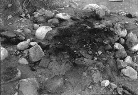
| Figure 7 Excavated hearth at Rainbow Bridge, 1994 (Courtesy of Glen Canyon NRA) | |
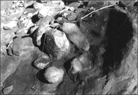
Until 1994, the only site recorded that stood in close proximity to the bridge was site 42SA17329. The site, as it was originally documented, consisted of several historic petroglyphs, including a horse petroglyph of Paiute or Navajo origin (date uncertain). The remainder of the inscriptions were Euro-American in affiliation and consisted mostly of names, dates, and other drawings carved by visitors to the bridge. The name of western author and adventurer Zane Grey, who first visited the bridge in 1913, was among those inscriptions. Located on and around the east leg of the bridge, site 42SA17329 was significant in and of itself. But the site also stood directly above the purported location of the famous altar that so many early visitors noted in their descriptions of the bridge. The altar's existence was never verified by contemporary archeologists because it disappeared sometime after the 1930s. During the extremely heavy rains of early 1994, water erosion at the foot of the bridge revealed a hearth structure that was definitely not of 20th century origin. Inspection of the hearth in September 1994 revealed that it was being damaged by vandalism. The Park Service decided an emergency excavation was in order. In November 1994, Park Service archeologists Chris Goetze and Tim W. Burchett commenced excavation and radiocarbon dating procedures on the hearth's contents. After consultation with the Navajo Tribe, Goetze and Burchett added the hearth to the described parameters of site 42SA17329 (based on proximity) and received approval for an emergency data recovery program. [27]
| |
| Figure 8 Excavated hearth at Rainbow Bridge, 1994 (Courtesy of Glen Canyon NRA) | |
The results of radiocarbon dates on the hearth were intriguing. The charcoal samples were dated at 540 ± 60 A.D., which placed the use of the hearth near the Basketmaker III period. However, Goetze and Burchett worried that this date was the result of "old wood" being used in the hearth. While this is possible, the data collected thus far from other nearby sites, including the N16 project, suggests that the Basketmaker III assignment was not too far off the mark. More importantly, even if the cultural assignment were adjusted to Pueblo II or Pueblo III, the hearth was indicative of early knowledge of the bridge and possibly reverence for it as spiritual icon. The report filed by Goetze and Burchett surmised that even if the Basketmaker III assignment was erroneous because of the "old wood" problem, "the hearth is still representative of activities including probable food processing, preparation, ceremonial, and social use of Rainbow Bridge." [28] This site, added to the dozens of others just beyond the monument's boundaries, evidences a thousand-year-old pattern of travel and occupation around Rainbow Bridge.
The archeological record tells a compelling story about Rainbow Bridge and its environs. There was definitely some human occupation of lower Bridge Canyon as late as 650 A.D. In the surrounding canyons and mesas, occupation by Paleoindians and Archaic Period humans took place as early as 8000 B.C. and continued through 1300 A.D. There is also the possibility that Paiute occupation began as early as the 12th century, though strong archeological data remains to be collected which would support such a claim definitively. However, based on the well established subsistence patterns observed by Dominguez and Escalante in 1776 (described later in this chapter), it seems probable that Southern Paiutes moved into the Navajo Mountain and Rainbow Bridge region at least as early as the 15th century. But there is another set of facts that describe the history of human occupation near Rainbow Bridge. Those facts are based on ethnohistory and cultural sources that do not necessarily rely on hard archeological data and should not be weighed in terms of criteria established in other cultures. Local Navajo and San Juan Southern Paiutes, as well as the Hopi to the south, view their interpretation of their history with the same veracity that Euro-American historians view the archeological record. [29] In this sense, modernism and traditionalism coexist at Rainbow Bridge.
In the contemporary Rainbow Bridge/Glen Canyon region there are numerous Native American peoples of various tribal affiliation. The largest tribe in the region is the Navajo Nation. The Navajo refer to themselves as Diné, which means "the People." Linguists trace the Diné language to the Lake Athapasca region of northwestern Canada. According to linguists, Athapascan-speaking peoples, which include the Diné, began migrating south from Canada between approximately 1000 A.D. and 1200 A.D. There is still debate today as to the path their journey followed. Two major schools have developed regarding Navajo entrance into the Southwest. One group of researchers contends that the Navajo moved south across the High Plains of the Southwest just prior to Coronado's presence on the Rio Grande in 1541, crossing the Continental Divide sometime after the Pueblo Revolt of 1680. The other school argues that the Navajo arrived in the Southwest before 1500 A.D., having traveled south along the east side of the Rocky Mountains. The former school suggests a southern terminus point further east than that claimed by the latter school. Both groups of scholars suggest that whatever the southernly terminus of Navajo migration, the Navajos migrated west into northern Arizona and southern Utah after reaching eastern New Mexico. [30] Both schools point to Tapacito Ruin (dated 1690 A.D.) near Gobernador Knob as the earliest evidence of the southern terminus. Tapacito is marked by Navajo pottery and forked-stick hogans. [31]
The exact time of Diné arrival in the Navajo Mountain/Rainbow Bridge area is difficult to ascertain. Many archaeologists and anthropologists suggest that when Coronado's Entrada campaign arrived at the Rio Grande in 1541, the Diné were still in the process of migrating into the Southwest. [32] Mary Shepardson and Blowden Hammond advanced a similar theory in their study of the contemporary Navajo community at Navajo Mountain.[33] Consolidating broad data from various scholars, Shepardson and Hammond contend that the Navajo Mountain area contains hundreds of sites of historic importance. The earliest period represented is Basketmaker II, dating from 1 A.D. to 600 A.D. Basketmaker III and Pueblo 1, II, and III are also represented sporadically all over the Rainbow Plateau and Paiute Mesa just south of the Arizona state line. These records suggest the early presence of pre-Puebloan peoples. The ancestral Puebloan cultures, commonly referred to by archeologists as Anasazi, are represented in various sites near Rainbow Bridge. Between 1200 A.D. and 1300 A.D., the ancestral Puebloan cultures withdrew from the sites known today as Keet Seel, Inscription House, and Betat' akin. Ancestral Puebloan culture did not reappear after 1350 A.D. [34]
Archeologist Alan Downer, a member of the Navajo Nation's Historic Preservation Office, has argued that this data represents more than the southern exodus of ancestral Puebloans. Downer asserts that using a more ethnographically sensitive reading of the archeological record reveals more about Navajo origins than any interpretation filtered through the Pecos model of development. He argues against the idea that Navajos were late arrivals to the Southwest in the early 1500s. Downer suggests that the fact that Athapascan speakers were spread throughout the Southwest mitigates that linguistic element as a determinant of Navajo origin. He contends that there are now enough sites of distinct Navajo origin dating to the early 14th century to rethink the late arrival theory:
As more and more early dates continue to be added to the data, they become more and more persuasive as a suite of evidence. There are now enough dates to the early 14th century to suggest that this represents a real occupation dating to the early 1300s. These dates come from sites that are plainly Navajo—that is, looking at the material culture evidence from the sites, there is no question that these sites are Navajo—the artifacts, the architecture, and the spatial organization are distinctively Navajo. Such sites are not found anywhere along any of the posited migration routes. It is reasonable to conclude that this distinctively Navajo site structure evolved in the Southwest. Based on any reasonable reading of the archeological record, these sites can not be seen as evidence of a new ethnic group suddenly moving into the area. [35]
Downer contends that these sites are so distinctive that it must have taken several centuries for this pattern to evolve, placing Navajos in the region in the early 12th century. This evolutionary model of development reflects the Navajo Nation's firm commitment to an ethnographic reading of the archeological record. The site data Downer referred to, including carbon dating results and site excavation reports, is housed at the Navajo Nation Historic Preservation Office in Window Rock, Arizona.
Contemporary archeology and ethnohistory suggests that these ancestral Puebloan peoples, who inhabited the canyons near Rainbow Bridge and Navajo Mountain, moved further south between 1200-1300 A.D. to the mesas of Arizona. They formed the Native American group known today as the Hopi. Christopher G. Johnson, in his master's thesis about the significance of Rainbow Bridge to various cultures, consolidated much of the Hopi tradition and archeological evidence as it pertains to Rainbow Bridge. Clan histories tell of a distinct link between the ancestral Puebloan peoples near Navajo Mountain and the contemporary Hopi. Hopi tradition claims that the first people to come to the southern Hopi mesas were the Snake People from Navajo Mountain (Toko' nabi). During this southern migration, certain numbers of the Snake People took up residence at places such as Moencopi and Wupatki (near Flagstaff). [36] Johnson cites Hopi oral traditions that mention Navajo Mountain as the starting point for Hopi southern migration. Beginning with the Snake People in 1150-1200 A.D., a large number of the remaining ancestral Hopi moved south to various mesas between 1250 A.D. and 1400 A.D.
Based on clan histories and certain pottery sherd analysis, the Hopi could have very likely begun their southern trek from Navajo Mountain. Hopi history tells that Coyote Peoples also came from Navajo Mountain. Rainbow Bridge also figures into the origin story of Hopi people. Johnson relates the oral history taken by A.M. Stephen in 1873 from an elder in the Snake Clan. The elder claimed that his people lived in snake skins that were suspended from the end of a rainbow. The opposite end of the rainbow touched Navajo Mountain. At some point, after the Snake people had acquired enough knowledge of Hopi lifeways from the gods, the skins were dropped from the rainbow onto the mountain, where the people emerged as men and women. [37]
In the 1930s, similar stories were told to Mormon missionaries who came into contact with the Hopi. Various Hopis told Mormon missionary Christian Christiansen that during the 17th century the Hopi used Rainbow Bridge as a refuge from invaders. The identity of the invaders is unclear, but the tradition of seeking security in Rainbow Bridge canyons is more certain. [38] During the Pueblo Revolt of 1680, Hopis claim that certain of their numbers fled north to the environs of Navajo Mountain and Rainbow Bridge. Historian Richard O. Clemmer suggests that Hopi tradition locates the older forest stands on Navajo Mountain, also referred to as Tokonavi, as the home for most Hopi Katchina spirits. Clemmer also contends that Navajo Mountain, Black Mesa, and Betatakin have always been revered as part of the Hopi aboriginal homeland. [39] The probability that some Hopis came to the Arizona mesas from Navajo Mountain is very high. There is enough archeological evidence to support the claim that they were near Navajo Mountain for a time; moreover, the incidence of Hopi contact reported by both Navajos and San Juan Paiutes supports the reality of a multi-cultural community around Navajo Mountain between the 16th and 18th centuries. Even archeologist Phil Geib admits that there are dozens of sites around Navajo Mountain that may possess early Paiute or Hopi affiliation. To date, Geib says, there simply has not been sufficient testing or excavation to verify those claims absolutely. Essentially, the evidence is there waiting to be utilized. [40]
By the time the Navajo were in the Southwest, the Glen Canyon region was a very active place. Ancestral Puebloan peoples were moving south to the Arizona mesas while Paiutes were forming their own bands along the San Juan river. The environs of Rainbow Bridge, Navajo Mountain, and the greater Glen Canyon were becoming a nexus of Indian activity. The Navajo occupied areas near the upper Chama and San Juan drainages in northern New Mexico around 1500 A.D. This area became the Dinétah (Navajo country). Navajos trace their emergence from the Fourth World, or Glittering World, to this region. A more complete version of the Navajo origin story, told by residents of the Navajo Mountain community, is detailed in Chapter 5. Based on Spanish sources, the Navajo first encountered Euro-Americans in 1541. In that year, Francisco Vasquez de Coronado made his historic trip into the Southwest. After crossing the San Pedro River into what would become Arizona, Coronado and his army pressed through what is now central New Mexico and onto its sprawling eastern plains. Near the Pecos River, Coronado encountered some of the ancestors of the Navajo, the Querechos. Based on the diaries of various observers, these early Navajos were unimpressed with Coronado and unafraid of the Spanish military presence. [41] Indeed, the Querechos were well established in the Southwest, evidenced by their use of horticulture. Spanish colonists arrived in the late sixteenth century, distinguishing the Navajo from other Athapascan peoples as Apaches de Nabahu ("Strangers of the Cultivated Fields"). [42]
Navajo oral tradition places the Diné in the Navajo Mountain area between 900 A.D. and 1150 A.D. As the Navajo emerged from the Fourth World, they eventually wandered into the area bounded by the Four Sacred Mountains. [43] During the wandering, they came by Navajo Mountain, finding many wild berries such as chokecherries, wild grape, and wild plum. The Diné stayed in the Navajo Mountain area for many years, enjoying the fruits of their natural surroundings. [44] Although there are large disparities between the archeological record and the oral tradition of the Diné, they were well ensconced in the larger Southwest by the time the Spanish arrived.
Relations between the Navajo and Spanish colonists remained fluid throughout the 17th century. As early as 1629, Friar Alonso de Benevides brokered with the Navajo, arranging peaceful ties between the Spanish at Santa Clara Pueblo and their Navajo neighbors. However, as more and more Spanish moved into the traditional Navajo homeland, the Navajo realized more opportunities to raid and prosper. The Spanish regional government was unaware of the ancestral Navajo tradition of raiding. Raiding was conducted for staples and prestige. The Navajo were accomplished raiders, developing their skills before the Spanish arrived by raiding the Pueblo Indians in the region. Rarely was anyone injured or killed at the hands of Navajo raiding parties. The Spanish brought horses and sheep into the region, animals that provided much needed bounty to the Navajo way of life. Spanish livestock was the primary goal of Navajo raids throughout the 17th and 18th centuries. Early on, the Navajo focused on Spanish settlements along the Rio Grande. [45]
What could have been a source of extensive economic and geographical expansion proved just the opposite for the Navajo. Although Navajo power was great in the region, Navajos still had to compete with northern tribes for territorial hunting grounds on the southern Great Plains. These tribes, including the Comanche, Pawnee, and Wichita, were better armed with weapons acquired from English and French traders. The Navajo only expanded for about one hundred years, finding their military match not in the Spanish but in the northern tribes. As a result of being squeezed between the Plains tribes to the north and the fortified Spanish to the south, the Navajo expanded within their traditional Dinétah. Spanish settlers and their Indian allies began reciprocating Navajo raids during this time. The Spanish raided for livestock and slaves. By the time the American military arrived in the region in the mid 19th century, the local Navajo and New Mexican populations had been raiding each other for well over one hundred years. Immense resentments and feuds were extant which did not favor the Navajo.
Raiding on the Spanish changed the Navajo lifeway forever. The introduction of horses, cattle, and most importantly sheep, to the Navajo economy helped the Navajo become the most self-sufficient Athapascan group in the Southwest. Dobyns and Euler refer to this period of mixed hunting, agriculture, and livestock domestication as the development of the triadic economy. Other Athapascan groups relied on the dual economy of hunting or raiding for meat and minimal agriculture for vegetable nutrients. These non-Navajo groups did not domesticate the livestock they acquired. Conversely, the Navajo, specifically Navajo women, began raising sheep for sustained use. While economic raiding was primarily a male dominated activity, Navajo women assumed the task of tending flocks of sheep while also trying to maintain horticulture. The Navajo sheep provided an enormous source of protein to the Diné. Sheep could be raised easily in the climate of the Southwest, and natural predation was extremely low. With this consistent source of fat and protein available to the Diné year-round, Navajo populations flourished during a time when most northern Native American groups were dwindling. Dobyns and Euler contend that the strong nutritional basis of the Navajo diet made all the difference when Navajos encountered disease or drought. [46]
The emerging clan structure of the 17th century Navajo made for great cultural fluidity. Men moved into their new spouse's camp, often marrying their new wife's sister as well. As the extended family units grew, various families interacted with each other and formed semi-formal land use communities. These communities always remained faithful to their primary clan affiliations but managed to coexist in pursuit of mutually beneficial land management. During this period the clans and extended family groups remained non-centralized; the contemporary concept of "tribe" was still forthcoming. Family groups operated relatively independently of the larger clans and were not responsible for or to each other. [47] This lack of a larger political structure proved very troublesome to the United States military in the 19th century when it tried to negotiate treaties that would oblige all Navajos to the terms of the treaty. The Diné simply had no centralized structure that would allow these treaties to be effective.
The Navajo expanded within the confines of the Four Corners region throughout the 17th and 18th centuries. The 19th century was not as hospitable for Navajo culture. Like the Great Plains to the north, the American Southwest was a target of Anglo westward expansion. After Mexico gained its independence from Spain in 1821, Mexican settlers expanded in every direction throughout the Southwest. During this period the incidence of violent contact between Navajos and Mexican settlers increased. Mexican military personnel were scattered along the southern edge of the traditional Navajo homeland. However, the newly formed Mexican government endured extended periods of turmoil during its early years Mexico found it difficult to maintain the frontier to the north and gradually phased out military control. The steady influx of Americans also added to the broil. American grazing and mineral interests soon eclipsed those of the Mexicans. But they shared a common foe in the Navajo, who were immune to the political imbroglio that was mounting between the United States and Mexico. Raiding continued to be an important activity to the Navajo and a constant source of anger to settlers. Mexican and American settlers retaliated frequently against Navajo bands. After 1848, however, Navajo fortunes took a dramatic turn for the worse.
In 1845, the United States government declared war on Mexico. The war concluded with the 1848 Treaty of Guadalupe Hidalgo, which placed the Navajo and their homeland squarely under the control of the United States government. The Americans were less than sympathetic to Navajo land claims in the region. The interests of American settlers, as well as those New Mexicans that fell under American control, were first and foremost to the new government. In Arizona, the Navajo also felt the pressure of expanding Anglo grazing interests which forced the Navajo and their flocks further north. Fortunately for the Diné in the Navajo Mountain region, this pressure was minimized by distance. Navajo Mountain was too far removed from the southern periphery of Dinétah, and so the basic pattern of Navajo life continued near Navajo Mountain. There were also very few Navajos in the mountain's environs in the mid 19th century [48]
The United States government, through its growing military presence in the Southwest, tried to negotiate with the Navajo. American military commanders signed five separate treaties with the leaders of various bands between 1846 and 1860. Each treaty was designed to accomplish three objectives: end Navajo raiding, limit the land base of the various bands, and encourage all Navajos to adopt a farming lifestyle which would make them more productive as Indians and less combative as neighbors. [49] In each instance, the Navajo violated the treaty's terms. The United States government as well as local military personnel did not understand Navajo culture well enough to comprehend the truly independent structure of Navajo bands. When one band leader signed a treaty, his authority extended only to the members of his band, not to the Navajo tribe as a whole. But the Americans thought just the opposite. As a result, raiding continued and Anglo hostility toward the Navajo intensified. In 1846, General Stephen Watts Kearny announced that the American military would end Navajo raids and bring order to the Southwest. It was a promise New Mexicans and Navajos would never forget. [50]
By 1862, American military personnel were unable to stop Navajo raiding. Hostilities were at their apex when Brigadier General James H. Carleton arrived on the scene. Because of the failure of numerous treaties and the increasing number Navajo attacks on civilian and military targets, Carleton felt he had to act. He ordered the removal of all Navajos to a reservation at Fort Sumner, near Bosque Redondo. Some historians claim that Carleton was simply bowing to the pressures of recent gold fever in New Mexico. By the summer of 1863, Carleton was not satisfied with the removal process. He brought Colonel Christopher "Kit" Carson from Taos to lead troops into the heart of Dinétah and eliminate the Navajo "threat."
Carson embraced his new duty with vigor, waging a "scorched earth" campaign against any and all Indians in the region. Carson and his men burned orchards, crops, destroyed hogans, and killed thousands of Navajo sheep and cattle. Within eight months, most of the remaining Navajos surrendered to Carson. They were marched to Fort Sumner and incarcerated. [51] This event is now know as the Long Walk. The Navajo Mountain community achieved historical prominence as a result of the Carson campaign. During the conflict, an unknown number of Navajos fled northwest to the canyons of Glen Canyon and avoided the Long Walk. Hashkéniinii was the most famous of these fleeing Navajos. [52] Historians vary on the estimated number of Navajos that Hashkéniinii led into the canyons below Navajo Mountain. The numbers range from two dozen to over one hundred. Regardless, he and his followers remained unmolested at Navajo Mountain during the remainder of Carson's campaign.
After word spread of the excellent protection afforded by Navajo Mountain's canyons and mesas, hundreds of Navajos joined Hashkéniinii. Navajos found the terrain formidable but suited to their need for concealment. Carson never pursued the Navajos beyond the San Juan River and so the environs of Navajo Mountain became home to a healthy population of Diné. The mountain's ecosystem provided wild foods and grazing land for Navajo flocks. These Navajos were quite taken with their new surroundings and with the divine providence that its protection represented. [53] Navajos viewed the mountain and its surrounding canyons with great reverence, identifying the region as a gift from the gods. [54]
In their new home, the Navajo Mountain Diné found a safe and compatible lifeway. Their presence around Navajo Mountain intensified the region's reputation among Anglos as "hostile territory" and thereby limited Anglo encroachment. In addition, by 1868 the American government no longer wanted the financial commitment of feeding more than 5,000 Navajo at Bosque Redondo's Fort Sumner. The Navajo endured four years of privation and internment before the Americans gave up. On May 28, 1868, General William Tecumseh Sherman and Colonel Samuel Tappan arrived at Bosque Redondo and began negotiating terms for a new treaty that would let the Navajos go home. On June 1, 1868 twenty-nine Navajo headmen placed their marks on the treaty and the Navajo were free. The Treaty of Bosque Redondo allowed for a large, defined reservation in the Dinétah, supplies of grain, and the return of 14,000 sheep to support the Navajo lifeway. [55]
The Diné at Navajo Mountain avoided the Long Walk as well as Fort Sumner. The events of the Carson campaign and the Long Walk made the Navajo Mountain community unique among the Navajo Tribe. They were immune from American attempts to make Navajos dependent on federal largesse. They also managed to retain a strong sense of their traditional culture and belief structures without the pain of American retribution. Effectively, the Navajo Mountain Diné endured prolonged conflict with the Americans and gave up little more than geography as the price of survival. Under the terms of Bosque Redondo, the Navajo Tribe continued to expand and profit for the remainder of the 19th century. The best data available indicate that the Navajo population increased an average of 2.4 percent each year between 1870 and 1900. In addition, sheep populations multiplied from 15,000 in 1869 to nearly 650,000 by 1907. [56]
In terms of proximity, the San Juan Band of Southern Paiutes is the next most significant group of Native Americans living in the Navajo Mountain/Rainbow Bridge area. The San Juan Paiute are an offshoot of Southern Paiutes. Approximately 3,000 years ago, Uto-Aztecan groups expanded south from their northern homelands. By 1000 A.D. these groups, consisting mainly of Northern Paiute, Southern Paiute, and Shoshonean peoples, were well ensconced in the Great Basin. During this period, these Numic speaking peoples intermingled with Fremont Complex peoples. [57] They gradually moved southwest into California and southeast into southern Utah and northern Arizona. The Southern Paiute refer to themselves as Nuwuvi. The official Nuwuvi tribal history claims that "although culturally related to such tribes as the Shoshone, the Utes, and the Northern Paiutes, the Nuwuvi spoke a slightly different language and had their own separate cultural identity." [58] In general, the term Southern Paiute refers to Uto-Chemehuevi groups.
The San Juan Paiutes replaced much of the Pueblo culture they encountered. In southwestern Utah, archeologists have excavated the distinctive ceramic remains of the Southern Paiutes in direct connection with Pueblo remains dated approximately 1150 A.D. The Southern Paiute pottery was rust colored and conical in shape, decorated with small incisions in circular patterns. Their pottery was highly differentiated from the Pueblo remains which were characterized by black/white or black/yellow coloring. The Southern Paiute probably first occupied the San Juan River region 1200 A.D. and 1300 A.D. The group closest to Navajo Mountain became known as the San Juan Band. [59]
Upon their arrival in the Southwest, the San Juan Paiute were a hunting and gathering population. They possessed no territory-wide political structure but did demonstrate a broad, uniform culture evidenced in both language and pottery. They employed highly adaptive subsistence patterns, making use of an array of food stuffs and natural materials. Archeological evidence suggests that the San Juan Paiute, operating northwest of Navajo Mountain, gathered various wild plants and hunted both rabbits and mountain sheep. They employed long bows and arrows as well as nets for this pursuit. Their homes during this period were a combination of temporary camps in their larger home territory and permanent settlements along the Little Colorado and San Juan rivers. During their occupation of the Southwest, they probably learned the rudiments of horticulture and corn processing from their Puebloan neighbors. This made it possible for the San Juan Paiute to establish sedentary lifeways and allowed them to become ensconced in the area west and north of Navajo Mountain. Various excavations have yielded milling stones used to grind corn, piñones, seeds, and meat. These stones differ from those used by Pueblos. [60] By the end of the 16th century, San Juan Paiutes were firmly settled along the San Juan River and in close proximity to Navajo Mountain. [61]
There is early documentary evidence of San Juan Paiute north of Navajo Mountain. In 1776, Franciscan Fathers Atanásio Dom&iacuite;nguez and Silvestre Vélez de Escalante led an expedition out of southern New Mexico into Utah. They moved north, circling much of the Wasatch Range, after which they headed south to present day Cedar City. There they encountered Paiute groups with semi-developed horticultural practices. Dominguez and Escalante then traveled east to the Colorado River, stopping at what is now called Lee's Ferry. The expedition traveled another forty miles before finding a fordable section of river. This spot is known today as the Crossing of the Fathers. On the south side of the river the expedition encountered a small group of San Juan Paiutes. Escalante wrote that "eight or ten leagues [25-30 miles] to the northeast of the ford there is a high, rounded peak which the Payuchis, whose country begins here, call Tucane [Navajo Mountain]." [62] Later in the trip and further southeast, Dominguez and Escalante stopped on the rim of the canyon above Navajo Creek. At a point on the mesa they saw "ranchos of the Yutas Payuchis, neighbors and friends of the Cosninas." [63]
As the number of competing groups increased in the larger Navajo Mountain region, raiding patterns and politics also changed. The role of various Ute groups as well as Hopi in the area suggests that the Navajo Mountain region was on the territorial periphery of both Utes and Hopis. Eventually the San Juan Paiute occupied a fairly distinct area near Navajo Mountain. Ethnographer Isabel T. Kelly defined their territory as "the area extended from Monument Valley to the Little Colorado and from the San Juan River to Black Mesa and the Moencopi Plateau." [64] This was a wide area, only the core of which was shared with the Navajo. Ute bands, specifically Weeminuche and Capote Utes, lived further east on the San Juan River but ranged in and out of the Navajo Mountain area. To the south were Hopi peoples who also made use of the resources on the southern slopes of Navajo Mountain. Moving to the San Juan region after 1300 A.D., the San Juan Paiute found much of the land they needed inhabited by Utes. The Weeminuche Ute claimed much of the San Juan as their own. Even though these eastern Ute groups shared a Numic linguistic pattern with the San Juan Paiute. the Weeminuche took advantage of their own mastery of horses in their pursuit of San Juan Paiute slaves. The Weeminuche preyed heavily on the San Juan Paiute all through the 18th and 19th centuries.
These Ute bands also targeted Navajos in their slave raids. The San Juan Paiute were not as quick to adopt sedentary livestock activities, perhaps because of their unwanted status as valuable slaves. [65] Navajos reciprocated against the Utes in terms of slaving and conducted a semi-profitable trade with their southern neighbors. These hostilities existed right up to the 1860s when the American government decided it would no longer tolerate tertiary aggression against its white citizens. However, it is fairly clear that the dynamics of the Navajo Mountain region as well as the larger Southwest were well established before the arrival of Americans and Mexicans. The politics of cooperation and conflict preceded any Anglo attempts to corral Native Americans and force them into the ill-fitting role of yeoman farmer.
It was around this time that the San Juan Paiute who were closest to Navajo Mountain were absorbed by the local Navajo population. Sometime after 1800, tensions between the San Juan Paiute and the Navajo became less important than the pressure both groups were encountering from the Utes to the northeast and the Hopis and New Mexicans to the south. San Juan Paiutes intermarried with Navajos and adopted clan affiliations along matrilineal lines. [66] There was always a distinct cultural fluidity among the Navajo when it came to adopting non-Navajos into clans. Navajo raiders often returned with female Ute, Mexican, or Puebloan captives. These captive women would usually bear children as monogamy was not the common practice among Navajos during this period. The Navajo response was to expand the aboriginal clan structure to account for these new additions to the population while maintaining the matrilineal structure of marriage and property ownership. Like other Native American societies, the Navajo assigned a less important social status to non-Navajos and their descendants; however, these assimilated captives retained the full benefit of Navajo rights in terms of property and inheritance. [67]
Another important part of the history of Rainbow Bridge NM occurred in the late 19th century as a result of the Treaty of Bosque Redondo. That treaty authorized the creation of the Navajo reservation, which surrounds the present-day monument. The original treaty reservation covered over three and a half million acres. Although the reservation represented only a fraction of the original Dinétah, it did offer some geographic continuity to Navajos. During a period when most tribes were being removed from their ancestral homelands to wholly unfamiliar areas, the Navajos were allowed to return to their own territory. Historian Peter Iverson notes that the ability of the Navajo to remain in their traditional lands and expand their territory almost four-fold is a testament to their tenacious roots in the region as well as the degree of value the United States government assigned to Navajo lands. [68] Another section of the Navajo reservation, known as the Paiute Strip, became a contentious issue to early visitors to Rainbow Bridge. The history of this specific section of the reservation, which surrounded Rainbow Bridge, is detailed in Chapter 4. Briefly stated, the conflict between whites and Navajos in the late 19th century did not conclude with the Treaty of Bosque Redondo. The area that the present-day monument occupies was embroiled in dispute long before Anglos ever laid eyes on the span of Rainbow Bridge.
There is excellent documentation of early Anglo travels in the canyons of Rainbow Bridge. The possibility that Spanish explorers found Rainbow Bridge in the 17th or 18th centuries remains remote. Generally these expeditions, such as the Dominguez-Escalante expedition of 1776, were heavily laden with men, horses and supplies. Moreover, given the religious motivations of many Spanish conquerors, there would have been little incentive to deviate from less difficult trails if there were no potential converts to be gained in the remote canyons surrounding Rainbow Bridge. If one accepts the veracity of a Latin inscription at Inscription House, located some fifty miles from the bridge, then Spanish explorers were in the region as early as 1661. But there is still little chance that large-scale expeditions made it up or down the narrow terrain of Bridge Canyon or Forbidding Canyon. The fact that no artifactual evidence has been discovered to support claims of early Spanish intrusion suggests it is a theory waiting to be proven.
In the 19th century, Anglos did encounter Rainbow Bridge and left certain evidence of those sightings. Many historians have inferred early 19th century visitation by fur trappers based on evidence found in areas near the bridge. Historian Stephen Jett contends that inscriptions left by Herman Wolf, Fred Smith, and W.C. Seifert near Navajo Mountain indicates Rainbow Bridge was likely observed during fur-trapping reconnaissance. [69] Historian C. Gregory Crampton claims that an 1836 inscription found in Cataract Canyon, attributed to French trapper Denis Julien, suggests an equal probability that Bridge Canyon and Forbidding Canyon were scouted during the great American fur-trading epoch. The inscription was first noticed by Robert B. Stanton in 1889 during an extended survey of Glen Canyon and the Colorado River. [70]
During the 19th century a rumor evolved about a great silver mine somewhere between the San Juan River and Navajo Mountain. It was the same El Dorado-style legend that developed elsewhere in the Southwest. Miners came and went throughout the middle of the 19th century in search of this great lost mine. In the 1880s, Cass Hite came to Glen Canyon and found placer gold near Dandy Crossing. Word spread and a small rush took place until the end of the decade. But in 1892, after miners discovered gold on the San Juan near Navajo Mountain, Crampton claims that every canyon nearby was prospected from top to bottom. [71] Neil Judd, one of the members of the first "official" expedition to locate Rainbow Bridge in 1909, acknowledged in a 1967 article that his party found mining tools at the mouth of Forbidding Canyon, less than five miles from the bridge. [72]
Given the topographic allure of Navajo Mountain as a mineral-bearing source, it seems altogether likely that prospectors hungry for wealth traversed all of its nearby canyons. The search for gold often led to new geographic data in the American West, and there is no reason to believe that the environs of Rainbow Bridge would be an exception to that pattern. In a statement taken by his daughter in 1929, William F. Williams claimed that he and his father, along with Chief Hashkéniinii, went in search of the infamous silver mine of the San Juan. Hashkéniinii led them to Bridge Canyon where they all saw the bridge first hand. Williams dated his first trip to the bridge as November 20, 1884. Williams also claimed that on the east buttress of the bridge, the names of Billy Ross, Montgomery, George Emmerson, Jim Black, Ed Randolph, and Wydel were clearly etched in the stone. [73] Secondary confirmation of these claims came in the form of a personal statement made by Jim Black, a prospector in the area during the late 19th century. In July 1930, Black claimed that during his three trips to the bridge in the 1890s he observed more than thirty names carved into the bridge and its nearby walls. In his statement, Black corroborated many of the same names Williams had detailed in 1929. [74] Why all these inscriptions were absent when the Cummings/Douglas party arrived in 1909 might never be known. Climatic patterns after 1884 could account for erosion of the original inscriptions. Vandalism is another possibility. In his article tracking the historical debate over who "discovered" Rainbow Bridge, Stephen Jett went so far as to volunteer personal observations of inscriptions near the foot of Navajo Mountain. These inscriptions were dated in the 1880s, corroborating some of the anecdotal proof that men like Emmerson, M.S. Foote, and J.P. Williams located the bridge before 1900. [75] Regardless, there is enough circumstantial evidence from mining related activity near Rainbow Bridge to say that non-Indians observed the bridge some time before the 20th century.
It is not surprising that the history of early human activity at Rainbow Bridge has taken a back seat to the more popularized 20th century accounts of "discovering" the bridge. Human contact with the bridge before the 20th century was characterized by minimal artifactual evidence, rumors, and a lack of photographs. But there is little doubt that humans have known of the bridge for many thousands of years. There is enough archeological evidence near Rainbow Bridge to suggest that it may have been seen by humans as early as 6000-4000 B.C. Evidence closer to the bridge, including the hearth uncovered in 1994, confirms that the bridge was utilized for any number of purposes at least one thousand years ago. This reality was not lost on those Anglos who first documented the location of Rainbow Bridge. As explained in Chapter 3, men like John Wetherill and Neil Judd admitted readily that other humans had come before them. As the 19th century closed, however, word of the bridge was out. Trapper, miners, and Navajos living nearby knew the great stone arch was in a tight canyon just off the north slope of Navajo Mountain. Having traveled in and around the region throughout the 19th century, seeing its many wonders and natural features, those men and women probably felt awe at the bridge's span without feeling the need to boast of its existence. They simply left their marks on the bridge or nearby canyon walls, just as men like John Wetherill and Zane Grey did in the 20th century.
| <<< Previous | <<< Contents >>> | Next >>> |
rabr/adhi/chap2.htm
Last Updated: 31-Aug-2016