|
Rainbow Bridge
A Bridge Between Cultures: An Administrative History of Rainbow Bridge National Monument |

|
CHAPTER 4:
Making It Work: Monument Development, 1910-1955
On May 30, 1910, President William Howard Taft issued a proclamation that designated the 160 acres surrounding the bridge as Rainbow Bridge National Monument (NM). Because the bridge was located on land administered by the General Land Office (GLO), the monument became the administrative responsibility of that agency. Before 1910, Rainbow Bridge enjoyed a quiet existence; after 1910, Rainbow Bridge was part of the federal system of land management and quickly became a contested space. This chapter focuses on elements of the monument's early development: administration, exploration, protection, and tourism. In the first few decades of the monument's official existence, there were numerous important scientific explorations of the region, various attempts to turn the monument into a national park, and organized efforts to promote the bridge's tourist potential. Between 1916 and 1955, Park Service employees as well as privately funded individuals spent more than thirty years trying to comprehend the vast resources of this relatively small monument.
Administering Rainbow Bridge NM between 1910 and 1916 was not a complex affair. Because of the its remote location, there was very little official activity at the monument. The administrative responsibility for the monument fell to John Wetherill in 1910. Wetherill was already the custodian for Navajo NM and in good position geographically to add the responsibility of Rainbow Bridge NM to his duties. Without question, Wetherill knew the region better than anyone, and his intimate local knowledge proved beneficial to many monument visitors.
In 1916, Congress passed the National Park System Organic Act, which authorized the creation of the National Park Service (NPS). After 1916, NPS was responsible for the administration of Rainbow Bridge NM. Based on the remote nature of the monument, as well as its positive relationship with John Wetherill, the Park Service maintained custodial management of the monument under Wetherill. NPS also continued the practice of making Rainbow Bridge part of the managerial purview of the custodian or superintendent of Navajo NM. This administrative structure remained in place until 1964, when control of Rainbow Bridge NM was transferred to the superintendent at Glen Canyon NRA (see chapter 6). The specific duty of managing Rainbow Bridge NM involved very little before 1964. Visitation was so limited until the late 1950s that visitor impact was minimal; this translated into very little demand for maintenance. Custodians and superintendents from Navajo NM, along with Park Service rangers, made semi-annual trips to Rainbow Bridge. Most of the time the trips were two or three days long, during which time they performed trail maintenance, signage repair, and replaced the visitor register at the bridge. [141]
Rainbow Bridge NM also fell under another management umbrella. In 1924, the Park Service formed the Southwestern National Monuments Office. Rainbow Bridge NM was part of a group of monuments under the administrative control of this office. The benefit to Rainbow Bridge was the Park Service's recognition of the need for more direct management control over remote locations such as Rainbow Bridge. As custodian, John Wetherill was made responsible to a local NPS administrator, Frank Pinkley, who had been Superintendent of Casa Grande NM since 1918. Pinkley was put in charge of fourteen national monuments throughout the Southwest region. Pinkley was a perfect choice, having worked his way up first with the General Land Office, and then NPS. The Park Service was not even ten years old at the time Pinkley began his administration of the Southwestern Monuments Group. In this capacity, "Boss" Pinkley (as he became known to his colleagues) fought an uphill battle for both recognition and adequate funding for his beloved national monuments. [142]
By 1927, Pinkley's monuments collectively attracted more visitors than Yellowstone on less than half of Yellowstone's budget. Pinkley often paid his own travel expenses and even went without salary at the end of the fiscal year to provide much needed repairs to various monuments. But Pinkley developed and grew as a park manager through good times and bad, always staying one step ahead of the new monuments being thrust under his care. At the time of his death in 1940, Pinkley administered 27 national monuments in four states. While Rainbow Bridge NM was part of this evolving rubric of regional control, local considerations and personalities continued to dominate the daily activity of the monument. The Southwestern National Monuments Group ceased administrative operation in 1957, just about the time that events at Rainbow Bridge became part of the national spotlight. But Pinkley watched over Rainbow Bridge with diligence during the sixteen years he administered it as part of the Southwest region. [143]
Despite the relative surety of NPS administration at Rainbow Bridge, the region that surrounded the monument was long contested in terms of ownership. Before Anglos came to the area in the middle of the 19th century, Rainbow Bridge and Navajo Mountain were claimed by Navajos, San Juan Southern Paiutes, and Hopis as part of their aboriginal homeland. The area was also on the fringe of territory claimed by numerous Native American tribes from southwestern Colorado. But with the Treaty of Bosque Redondo in 1868, the United States government was thrown into the mix of claimants on Rainbow Bridge. The status of the territory surrounding the bridge, an area referred to as the Paiute Strip, was in flux from the moment the Bosque Redondo treaty created the Navajo reservation. Even after the declaration of Rainbow Bridge NM, the status of the surrounding environs was not settled.
Originally the Navajo reservation was bifurcated by the Arizona-New Mexico state line. Its northern border was the Four Corners intersection and its southern border was only a few miles north of present day Window Rock, Arizona. From 1878 to 1934, the Navajo reservation was expanded by executive order ten times and by congressional act three times. Modifications to the reservation between 1878 and 1886 included the creation of the Hopi reservation in December of 1882, a section nearly as large as the original Navajo treaty reservation. The Hopi reservation was bounded on all four sides by the Navajo reservation. An executive order of May 17, 1884, by President Chester A. Arthur, added the portion of land known as the Paiute Strip. [144]
| |
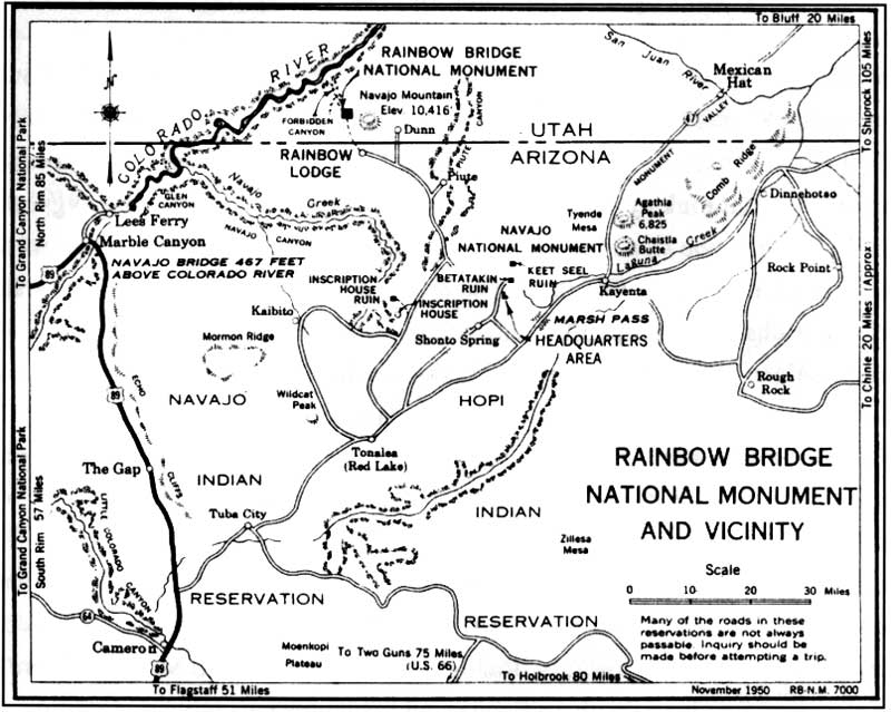
| Figure 20 Rainbow Bridge National Monument and vicinity (From 1950 NPS brochure. Courtesy of Intermountain Support Office) (click on image for an enlargement in a new window) | |
The history of the Paiute Strip is an interesting odyssey. The Paiute Strip is the home of Rainbow Bridge. Its southern boundary is the Utah/Arizona border and its eastern border is the Utah/Colorado border, moving from Four Corners north to the point where the San Juan River crosses into the Colorado. The northern and western borders are created by the westerly flowing San Juan River, as it moves from the Utah/Colorado border north, then west, until it turns south and joins the Colorado River. Originally part of the 1884 addition to the Navajo reservation, President Benjamin Harrison returned 431,160 acres of the Paiute Strip to the public domain in November 1892. Historian Bill Acrey contends that prospectors had long desired to explore the region for its potential mineral wealth and in turn pressured the President to make the Paiute Strip available to mining survey. [145] However, in 1908, the expanding Navajo population of both people and sheep motivated Congress to withdraw the Strip for use by multiple Native American groups. During this period, the area was known as the Paiute Strip San Juan Reservation, although much of the prime grazing land was overrun by Navajo flocks. The San Juan Southern Paiute had long considered this area part of their ancestral homeland. But Navajo pressure for competing use was too great for the small band of Southern Paiute who made Navajo Mountain their home. The Paiute Strip reservation remained under the administration of the Western Navajo Agency until 1922. [146]
Unfortunately for the San Juan Southern Paiute, the reservation designation did not last. The San Juan Southern Paiute were hit hard by an influenza epidemic in 1918. Over the next two decades their numbers were cut by seventy percent, from three hundred people to fewer than eighty. Cultural historian Stephen Trimble contends that a poorly informed agent from the Bureau of Indian Affairs visited the Paiute Strip in 1922. Seeing few Paiutes in the area, the agent informed his superiors of the situation. Within weeks, Secretary of the Interior Albert Fall bowed to Monticello, Utah mineral interests and returned the Strip to the public domain once again in 1922. Owing to pressure from local residents as well as the lack of any significant mineral discoveries, Congress returned the Paiute Strip (less the one hundred and sixty acres that comprised Rainbow Bridge NM) permanently to the Navajo reservation in 1933. [147]
With the monument established, exploration of its environs began in earnest. Despite the fact that Native Americans knew about the bridge for centuries, the rest of the country knew very little about Rainbow Bridge or its surrounding ecosystem. The Cummings/Douglass expedition revealed only the most rudimentary data about Rainbow Bridge and even less about the northwestern slope of Navajo Mountain. Before 1910, most of the exploration in the region focused on Tsegi Canyon and the many ancient Puebloan structures it contained. What waited for Anglos at Rainbow Bridge was a topography as diverse as any encountered previously, as well as evidence of early human habitation.

| |
| Figure 21 Kayenta Trading Post, 1912 (Stuart M. Young Collection, NAU.PH., Cline Library, Northern Arizona University) | |
The official life of the monument started slowly. In addition to the few scholarly articles published after the 1909 expedition, the early visits of notable men like Theodore Roosevelt and Zane Grey helped spread the word of the monument's stunning topography. Roosevelt and Grey both visited the bridge in 1913. In May of that year, Grey employed John Wetherill and Nasja Begay to guide him to the bridge. Grey was awed by the rugged state of nature that surrounded him. When Grey reached the bridge, he was dumbfounded. In his 1922 autobiographical collection of essays, Tales of Lonely Trails, Grey described Rainbow Bridge saying ". . . this thing was glorious. It absolutely silenced me." [148] Grey returned to Rainbow Bridge several times, his last trip occurring in 1922. He went on to include scenes from those excursions in many of his most famous books. The Rainbow Trail was Grey's fictionalized tribute to Rainbow Bridge. These accounts helped popularize the bridge with literate America at a time when visual mass media was still a futuristic concept.
Theodore Roosevelt was no less impressed by Rainbow Bridge. In August 1913, Roosevelt was in the Southwest doing the things he loved most: hunting and exploring. As one of the founders of the Boone and Crockett Club, Roosevelt thought of the Southwest as the last vestige of America's untamed wilderness. Roosevelt employed Wetherill as a guide and set out for the bridge around August 9, 1913. When he reached the bridge three days later (the trip to Rainbow Bridge was now a matter of following the trail for guides like Wetherill) Roosevelt felt the intense emotion of early explorers. In his published description of the experience, authored only a month after the trip, Roosevelt said that Rainbow Bridge ". . . is a triumphal arch rather than a bridge, and spans the torrent bed in a majesty never shared by any arch ever reared by the mightiest conquerors among the nations of mankind." [49] Despite the flowery prose, Roosevelt's impression of Rainbow Bridge inspired further exploration of the region. Roosevelt and Grey can be credited with popularizing what was then one of the most remote national monuments in the country. They certainly contributed to the reality of increased visitation at Rainbow Bridge, which doubled between 1913 and 1922 to over eighty visitors per year. But the immature fiscal and administrative structure of the National Park Service could not accommodate structural improvements to the monument, at least not by 1922. The early priorities of the Park Service involved the development of more popular destinations such as Yellowstone National Park. The extremely remote location of Rainbow Bridge limited its annual visitation, which hindered making the monument a budgetary priority.
John Wetherill also played a large role in the early popularization of Rainbow Bridge and its surrounding monument. After leading the first publicized expedition to the bridge in 1909, Wetherill's notoriety grew as the best man to guide people to the bridge. As the monument's first custodian, working under the supervision of the General Land Office, Wetherill was responsible for trail maintenance and bridge integrity (in addition to his own guide service). The role of custodian at monuments in the 1910s and 1920s was largely volunteeristic in nature. Called "dollar-a-year" men (based on the rate of pay extended by the federal government), custodians generally pursued their duties out of a personal love for the immediate surroundings and the desire to contribute to the monument's preservation. Usually custodians, like Wetherill, were chosen based on their strong ties to the local area and their inordinate knowledge of the monument's surroundings. This was definitely the criteria used in choosing John Wetherill to watch over Rainbow Bridge. Any conflict of interest that might have existed between Wetherill's position as custodian and his ownership of a private guide service was too small for the government to worry about. Wetherill was an excellent custodian and an even better guide. In 1909, barely two weeks after the August 14 discovery party, he guided the first woman, Helen Townsend, to the bridge, along with her brother Arthur. [150] For all the historical debate over his role in the history of the bridge, one fact remains incontrovertible: Wetherill brought hundreds of people to the bridge and helped spread the word of the Park Service's commitment to preserving the structure for future generations. This was the mission of the Park Service after it became the monument's managing agency in 1916, and Wetherill pursued that mission admirably.
John and Louisa Wetherill stayed at Oljeto until late 1910. In 1911, they moved south of Oljeto to Todanestya, Arizona, which Wetherill renamed as Kayenta. From here they operated a guide service and trading post operation until 1924. During the Kayenta years, the Wetherills continued to increase the popularity of Rainbow Bridge. It was during the Kayenta phase that John Wetherill came into contact with Theodore Roosevelt, Zane Grey, and eventually Charles L. Bernheimer. From the Kayenta location, trips to the bridge could include stops in Tsegi Canyon and camps at Keet Seel and Betat' akin. The only drawback to operating out of Kayenta was its seventy-mile distance from the bridge. But, as the Wetherills were the only guide service for over a decade, this was little more than an inconvenience.
Tourism and exploration operated on a dual plane at the monument between 1910 and 1955. There were significant explorations of the monument's interior which tried to assess the best route to the bridge as well as the monument's biological and geological scope. One of the most popularized set of expeditions to the bridge were those inspired by Charles L. Bernheimer in the 1920s. Bernheimer described himself as a "tenderfoot and cliff dweller from Manhattan." [151] Bernheimer was that and more. A textile tycoon, Bernheimer had a passion for the Southwest. He spent many summer months in the Four Corners region, exploring and recording much of what he saw. In 1920, he employed Wetherill to guide him to the bridge. Awed at the spectacular edifice, Bernheimer decided that the bridge could be accessed more directly via some undiscovered western route. In 1920, the bridge was still being reached in the final stage via the original approach which included numerous canyon crossings and tiring course deviations. Bernheimer returned in 1921 to help create a more direct route that avoided delays in Bald Rock Canyon. [152]
The 1921 expedition proved to be quite exceptional. Bernheimer and Wetherill, among other feats, circumnavigated Navajo Mountain and located Redbud Pass as the likely candidate for a western approach to the bridge. However, Wetherill reported to Bernheimer that approaching the bridge from that point would be impossible due to natural impediments. Bernheimer returned the following year with Earl H. Morris of the American Museum of Natural History. With Wetherill as guide, the team took up the sole task of "creating" an approach to the bridge via Redbud Pass. Utilizing dynamite and chisels, Bernheimer and his crew worked for a week to create a path wide enough to lead horses through. They finished their efforts on July 5, 1922, riding through the newly formed Redbud Pass and into Bridge Canyon toward Rainbow Bridge. [153]
The completed route ran from Kayenta up Tsegi Canyon and then due north to the southern foot of Navajo Mountain. Here the trail forked; the east fork followed the traditional route around Navajo Mountain from east to west and into Bridge Creek. This is known historically as the Wetherill Trail. But the west fork, reconnoitered during the 1921 and 1922 Bernheimer expeditions, followed Horse Canyon into Cliff Canyon. It then made use of Redbud Pass and the more direct drop into Bridge Canyon. [154] From any camp situated along the southern slopes of Navajo Mountain, the new trail offered a more direct path to the bridge, ranging from thirteen to twenty miles depending on the starting point. The great irony of creating this new route was it made locations north of Kayenta more appealing as base camps. In 1924, S.I. Richardson recognized that very fact.

| |
| Figure 22 Redbud Pass (Phillip Johnston Collection, Cline Library, NAU.PH.413.103, Northern Arizona University) | |
The establishment of Rainbow Lodge was inevitable from a tourism perspective. The Wetherills were too far from the bridge and could not hope to monopolize the tourist trade forever. John Wetherill had made a good living guiding men like Grey and Bernheimer to the bridge. But as public knowledge of the bridge grew, others sought a living at guiding "tenderfoots" into the monument. S.I. Richardson and his brother Hubert were among those who saw more than the awesome natural beauty of the bridge; they saw economic potential. The Richardson brothers came to the Southwest to escape the harsh life imposed on them by their fundamentalist father. After working with relatives in the trading post business, the brothers took a pack trip from Kaibito to the bridge. It was this trip that inspired them to start a guide and trading post business on the southern slope of Navajo Mountain. Their plan included construction of a road from Tonalea, Arizona to their new Rainbow Lodge and Trading Post at Willow Springs. [155]
It was an ambitious plan. Permits, construction delays, threats from local Navajos, and canyon obstructions threatened to derail the project. But S.I. and Hubert were not dissuaded from realizing their dream. Using hired and family labor, the Richardsons finished construction of the lodge in late 1923. The Richardsons also managed to secure the official sanction of the Bureau of Indian Affairs (BIA). Unbeknownst to the Park Service, the BIA issued S.I. Richardson a permit to operate the Rainbow Natural Bridge Transportation Company. The Park Service was unaware of Richardson's permitted operation until May 1924. [156] The lodge started receiving visitors, even before guest accommodations were complete, in March 1924. Regular pack trips to the bridge began in early 1925. [157] Competition for the Wetherill clients had begun.
| |
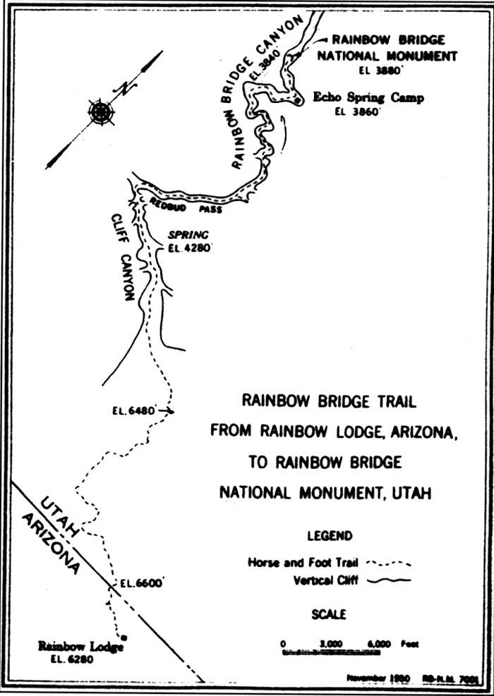
| Figure 23 Rainbow Trail from Rainbow Lodge (Courtesy of Intermountain Support Office) (click on image for an enlargement in a new window) | |
In order to improve his odds for success at Rainbow Bridge, Hubert Richardson lobbied the Park Service to appoint Homer Arnn custodian of the monument. Arnn was the chief packer for the Richardsons and would have been in a uniquely powerful position if appointed custodian. Even the Park Service recognized that custodians were in frequent contact with visitors, making custodianship and guiding a lucrative combination. The Park Service responded with consideration, indicating that "we would like to get a good man to act as custodian at the Rainbow Bridge." [158] But when the request made it to the review of Acting Director Arno B. Cammerer, all the cards were laid on the table. Cammerer wrote to Frank Pinkley, then Superintendent of Casa Grande National Monument, "perhaps the reason Mr. Richardson is anxious to have Arnn appointed as custodian of the Rainbow Bridge Monument is that this would give him official recognition as the Rainbow guide and some misunderstanding might arise in this connection with Mr. Wetherill." [159] It seemed that certain Park Service employees did not know that John Wetherill served the dual role of custodian for Navajo NM and Rainbow Bridge. In any event, Arnn's custodianship was denied by the Park Service in the form of it never being proposed officially.
Competing with the Wetherills had its price. Being so close to the bridge meant being very far from supply towns. Everything necessary to Rainbow Lodge's operation had to be trucked in from somewhere else: Flagstaff, Gallup, or other towns. The Richardsons realized quickly that business would have to be brisk to meet the cost of operating in such a remote location. In 1926, S.I. and Susie Richardson sold their share in the Rainbow Lodge to Hubert Richardson and left Navajo Mountain for Red Mesa. Hubert gave overall management control to Stanton Borum, one of the original partners in the venture. Hubert hired his brother-in-law, Bill Wilson and his wife Katherine to handle the daily lodge operations: guest services, trail and lodge maintenance, and advertising. [160]
The Wilsons came to Rainbow Bridge from Grand Canyon National Park. Wilson worked as a pack-master for several years at Grand Canyon under the direction of Superintendent M.R. Tillotson. He had made quite an impression on Tillotson during the years at Grand Canyon. Superintendent Tillotson, after reading a Park Service publication that indicated Rainbow Bridge NM lacked a custodian, immediately recommended Bill Wilson to the Director for the custodial position. Tillotson wrote of Wilson that "it would be difficult to find anyone more interested in the preservation of the monument than he and he is certainly the nearest white man to it." [161] In fact, John Wetherill was still the official custodian of Rainbow Bridge, a duty that Wetherill also performed at nearby Navajo NM. Whether or not Tillotson knew about Wetherill's role would be speculative. But in his letter, Tillotson detailed numerous other trading posts that lay some distance beyond Rainbow Lodge. Kayenta was not mentioned among them. In fact, in extolling the virtues of Rainbow Lodge, Tillotson compared Wilson's services to the other alternative, a ten-day pack trip around the north side of Navajo Mountain. Any information as to who ran these alternative pack trips was omitted from the letter. In any event, the recommendation of Wilson for custodian was denied by the Director based on the advice of Frank Pinkley. Pinkley said that there were reasons for not appointing Wilson that Tillotson had omitted from his glowing recommendation. Those reasons were known only to the participants as they were never enumerated in any Park Service correspondence. [162]
It was apparent that even the eased access afforded by the Richardson road improvements were not enough to stimulate vigorous Park Service management. Budgetary limitations still in place as a result of World War II severely restricted structural improvements at the monument. In 1946, Hubert Richardson sold his interest in the lodge to Barry Goldwater, future Arizona Senator and presidential candidate.
World War II handicapped business at the lodge. Very little recreational travel took place during the war, and remote locations like Rainbow Lodge were hit the hardest. But Goldwater loved the country around Rainbow Bridge. He had bought into the Richardson operation in the 1930s as a partner and in 1946, after the conclusion of the war, decided he wanted to have a go at running a successful tourist operation. The lodge did little business during the war, with the Wilsons leaving Navajo Mountain for a brief time to secure employment elsewhere. The lodge was virtually unused for nearly five years. With wartime fuel restrictions lifted by 1946, people began touring the Southwest again. Goldwater had guessed well regarding post-war tourism. In 1923, annual visitation to the bridge was only 142 people. After 1945, visitation went up every year, reaching a high of 1,081 in 1955. Goldwater secured the promise of the Park Service to distribute Rainbow Lodge pamphlets to all persons inquiring about services at Rainbow Bridge. [163]

| |
| Figure 24 Rainbow Lodge, 1950 (Gladys Brodenson Collection, NAU.PH.97.9. 129, Cline Library. Northern Arizona University) | |
In high hopes of success, Goldwater sent 1,500 pamphlets to the Park Service's information office. Unfortunately the lodge burned to the ground in August 1951, leaving nothing but high hopes. Operations were transferred to the only building large enough to accommodate guest functions: a recently constructed stone garage. The Wilsons decided to retire after the fire and in 1952 moved to Clarksdale, Arizona. Myles Headrick, lodge manager after Hubert Richardson sold out, became partners with Goldwater. Goldwater and Headrick hired Merritt and Nona Holloway to replace the Wilsons and serve as hosts. The lodge was never rebuilt along its original lines. Trips to the bridge via boat tours on the Colorado River and the advent of Lake Powell in 1962 made continuing land-based travel to Rainbow Bridge a futile endeavor. Operations at Rainbow Lodge continued until Goldwater's priorities and finances shifted to national politics. The Rainbow Bridge and Hotel Company closed in 1965. But the era of guided pack services had firmly ensconced Rainbow Bridge NM on the recreational consciousness of thousands of Americans who would later lament the era's passage. [164]
River trips to the bridge also took on increased significance between 1935 and 1955. Norman Nevills operated the first tourist operation in Glen Canyon that successfully focused on Rainbow Bridge. Nevills operated from Mexican Hat, Utah, just north of the monument on the San Juan River. He was instrumental in designing boats that could withstand the harsh conditions of the San Juan rapids. He guided his first paying customers to the bridge via the San Juan in March 1936. Within a few years, Nevills was operating a commercially profitable river-based guide service that included a side trip to Rainbow Bridge on every voyage. Unfortunately, Nevills and his wife Doris died in a plane crash in 1949. But it was Nevills who introduced men like Barry Goldwater and Wallace Stegner to the beauties of Glen Canyon. His boat-building skill and technical prowess at running the river inspired many other guides in the years to come. [165]
Other river runners made Rainbow Bridge part of their itinerary as well. Art Greene started running clients to Rainbow Bridge in the 1940s. He traveled up the Colorado River from Lee's Ferry. Greene used modified air-boats, like those then used in the Florida Everglades. Greene's venture was never extremely profitable as the boats required tremendous amounts of fuel, which drove up the price of his trips. But Greene was important for another reason. When construction started on Glen Canyon Damn in October 1956, Greene acquired a lease on a large tract of land above the dam and built a small resort and marina. The marina became known as Wahweap. He continued to run river trips to Rainbow Bridge until 1962. Greene sold his interest in Wahweap to the Del Webb Corporation in 1976 and died in Phoenix, Arizona in 1978. Greene was an influential man in his time, guiding many prominent people to the bridge prior to the construction of Glen Canyon Dam. [166]
In terms of contemporary issues, the administrative life of Rainbow Bridge NM from 1945 to 1970 was dominated by the proposal and construction of Glen Canyon Dam. However, plans to dam the canyons near Rainbow Bridge began early in the monument's life, long before the Colorado River Storage Act which authorized Glen Canyon Dam. Reclamation as a federal management philosophy was codified in law in June 1902 with the passage of the Newlands Reclamation Act. The spirit of reclamation infected the West. With so many rivers, the western states were ripe for reclamation projects that would bring paradise to the deserts. This belief in science controlling nature to the betterment of American lives was the driving force in the Bureau of Reclamation throughout the first sixty years of the Bureau's existence. By 1914, tens of millions of dollars were spent trying to irrigate the West through reclamation.
This spirit of reclamation made the 1920s a significant period in the official life of Rainbow Bridge NM. The states that comprised the Upper Colorado River Basin wanted more control over the development and distribution of Colorado River waters. To this end the Upper Basin states lobbied Congress for the right to form a compact of states and employ the doctrine of prior appropriation as it was codified in law in the 1922 case Wyoming v. California. The doctrine of prior appropriation held that whoever developed a water source for beneficial use first held permanent rights to that water—first in time, first in right. The Upper Basin states proposed a series of dams, funded in part by the Bureau of Reclamation, to help secure water from the Colorado River for the benefit of the Upper Basin. But there was no comprehensive map of the Glen Canyon region to aid in deciding possible dam placement. To this end, the U.S.G.S. conducted a mapping project of the Colorado River basin and Glen Canyon. Included in the U.S.G.S. survey were Bridge Creek and Aztec Creek. When the project was finished in 1923, Rainbow Bridge and its monument environs were part of the topographic data base. [167] The other significant result of the survey was the publication of the first plan to erect a dam in Glen Canyon and reclaim the meandering Colorado River for the benefit of the Upper Basin states.
As the water needs of southern California expanded, the Upper Basin states knew that reclamation was their only hope of making use of the waters of the Colorado River. One man working for the United States Geological Survey also believed the Colorado could be reclaimed. In 1916, Edward Clyde (E.C.) LaRue, chief hydrologist for the U.S.G.S., was convinced that reclamation and control of the Colorado River could be accomplished. LaRue favored a location somewhere in or near Glen Canyon. His first vision of a dam for the Colorado was a two hundred and forty-four foot gravity dam just below the mouth of the Paria River near Lee's Ferry, Utah. But LaRue changed his mind after taking part in the 1921 general mapping survey of Glen Canyon. After seeing the length of the lower Colorado River as it passed through Glen Canyon, LaRue proposed a 780 foot dam be built four miles upstream from Lee's Ferry. His larger proposal would generate a reservoir of 50 million acre feet of water. LaRue thought this could be effectively accomplished by simply blasting the walls of Glen Canyon and modifying the resultant massive choke-stone of debris into a Glen Canyon dam. LaRue published his proposal a year after the completion of the general mapping survey. [168] Twenty years later, when the Bureau of Reclamation and others looked seriously at plans to dam sections of the Colorado, LaRue's idea was revived and formed the nucleus of the Colorado River Storage Project's plan for a Glen Canyon unit.
Charles Bernheimer's book Rainbow Bridge, as well as his various expeditions, revealed the vast diversity of the environs of Rainbow Bridge NM to a growing audience. That same audience also watched as the Upper Basin states signed the Colorado River Compact in 1922. The purpose of the Compact was no secret; dams were to be erected along the length of the Colorado River. Reclamation as a working philosophy was very popular in the West. Reclamation meant jobs, resources, and most importantly, control of the future distribution of the West's most valuable resource. Water had always been the most important issue in the Western states and the Compact reinforced that belief. Bernheimer, among others, recognized the possibility that dams could go up throughout Glen Canyon. To protect his beloved Rainbow Bridge, Bernheimer began a campaign in 1928 to lobby Congress to modify the monument's status to national park. He wrote letters to members of Congress, as well as NPS Director Stephen T. Mather, [169] Bernheimer also solicited the support of The American Scenic and Historic Preservation Society. This would be the first of many such schemes to make Rainbow Bridge a national park.
Acting Director Arno B. Cammerer replied to Bernheimer and others by pointing out the realistic problems of changing Rainbow Bridge to a national park: the lack of local infrastructure; the rugged terrain surrounding the monument which precluded development of roads and campgrounds; and the uncertain status of the surrounding lands. [170] Cammerer and others recognized the delicacy of dealing with both the Navajo Tribe and the San Juan Southern Paiute over the issue of land acquisition. The Paiute Strip, which surrounded the monument, had changed hands many times by 1928 and had only recently (1922) been returned to the public domain. At nearly the same time that Bernheimer proposed his plan, pressure was growing from many quarters to return the Strip to the local Navajos and Paiutes, and the Park Service did not want to jeopardize that process by attempting to accession more acreage in pursuit of a Rainbow Bridge national park. [171] By 1930, the Bureau of Indian Affairs was in the process of preparing legislation for Congress to return the Paiute Strip to Navajo control. Believing this transfer was a foregone conclusion, the Park Service did not seriously consider most early proposals to modify the monument's status. [172]
Proposals to make Rainbow Bridge a national park were not limited to the geographic boundaries of the Paiute Strip. Charles Bernheimer proposed another park, comprised of three sections, that was significantly larger than his 1928 vision. In 1931, despite the imminent return of the Paiute Strip to Navajo control, boosters formulated plans to create a Navajo National Park. The proposed park included all of the Paiute Strip, Navajo NM, and Natural Bridges NM. On the map it resembled a giant east/west diamond with Navajo Mountain near the center. Bernheimer lobbied tirelessly for his dream park. He obtained the support of the Clark Wissler and The American Museum of Natural History. [173] There was immense popular support for such a park. Letters poured into the Park Service's various offices between 1931 and 1933. The Salt Lake City Telegraph reported, "In the plans, the new national park will extend from Utah into northern Arizona, and will include the following: Rainbow natural bridge, Navajo national monument, the Goosenecks in the San Juan river, Monument valley, the Utah natural bridges [national monument], and Arch canyon." [174] The supporters of this new park were getting press as well as official interest. But even as support grew, one problem remained the same: the land in the proposed park was almost entirely controlled by the Navajo Nation. The only land that was not under their direct control (the Paiute Strip) soon would be.
In March 1931 the Park Service investigated the possibility of establishing the proposed Navajo National Park. To that end, Grand Canyon National Park Superintendent M.R. Tillotson and Yellowstone National Park Superintendent Roger W. Toll conducted a fact-finding trip to Rainbow Bridge country. Their conclusion was somewhat path breaking. In their assessment they vehemently supported establishing a Navajo National Park. Toll wrote, "this proposed national park would have great interest to the American public because of its unusual features of ethnology and archaeology, as well as because of its unique and remarkable scenic qualities." [175] The Park Service clearly recognized the diverse cultural makeup of the region surrounding Rainbow Bridge and thought it significant enough to include ethnology as reason to protect the region via national park status. This was exceptional thinking given the political climate in which Toll wrote this report. At nearly the same time that Toll and Tillotson toured the Navajo reservation, BIA administrators met in Washington, D.C. to finalize plans for large-scale reductions of Navajo sheep herds, a federal policy that most Navajos detested. Commissioner of Indian Affairs John Collier was an anathema to Navajos at large and especially to the Navajo Tribal Council. This feeling was so intense that a majority of Navajos voted against Tribal incorporation under the Wheeler-Howard Act just because Collier supported a federally approved Navajo constitution. [176] Federal involvement in the lives of Navajos at any level was not popular with members of the Tribe in the 1930s. Regardless, the Park Service supported a Navajo National Park because they thought would benefit everyone involved.
As part of a larger trip to the West, Director Horace M. Albright made his way to Rainbow Bridge and Navajo Mountain in late July 1932. At this time, John Wetherill was still the custodian of both Rainbow Bridge and Navajo NM. Prior to his trip, Director Albright corresponded with both Charles Bernheimer and Frederic A. Stearns. Bernheimer and Stearns tried to coax Albright into staying with and employing the Wetherills during the Rainbow Bridge leg of the journey. [177] There were still factions at work near the bridge, and those factions were divided along guide services. The Wetherills had long been thought of as the rightful heirs to the mantle of Rainbow Bridge tourism. After all, it was John Wetherill who "found" the bridge. Some locals thought of the Richardsons as intruders who made their living by capitalizing on the trail-breaking hard work of Wetherill and Bernheimer. Geographic proximity finally settled the argument. When Albright visited Rainbow Bridge in July 1932, he employed the Wilsons at Rainbow Lodge rather than Wetherill. The Director's aides selected Rainbow Lodge based on its fifteen-mile distance from the bridge. The Director was on a tight schedule and could not afford a ten-day pack trip that roamed all over the region. The Director was so impressed by Rainbow Bridge and the nearby lodge that he wrote to Katherine Wilson thanking her for their accommodations. Albright even offered support to the Wilsons, saying "I hope we [the Park Service] can find some way of helping your enterprise." [178] The Depression was in full swing and business was slow. Any kind of support, especially from the Director of the National Park Service, was welcomed by the Wilsons.
Director Albright's 1932 trip definitely augmented popular support for the idea to modify Rainbow Bridge's monument status along the lines of the Bernheimer plan. After seeing the region first hand, Albright was convinced that a national park in some form should exist near the Four Corners. But the Park Service's desires could not keep pace with the political climate in which they existed. Because of the demands of the Depression, Congress was more inclined to employ men and women to improve existing units of the national park system, rather than create new units. Between 1925 and 1928, twenty-one new national monuments were established by Presidential proclamation. In the first years of the Depression, between 1929 and 1932, only eight monuments were added to the national park system. [179] In addition to the economic chaos that eclipsed the Park Service's hopes, Congressional sentiment toward Native Americans was reaching crisis. At the same time that John Collier was arguing for Navajo stock reduction, Congress was debating passage of the Wheeler-Howard Act, commonly known as the Indian Reorganization Act. The mood of the first Roosevelt administration was one of conciliation toward Native Americans. Based in part on the liberal tendencies of the administration and the deplorable conditions revealed in the 1928 Meriam Report, that mood became the inspiration for letting the Navajo Tribe keep its ancestral homelands intact. [180] As a result of these forces, Congress returned the Paiute Strip to Navajo control in 1933. Negotiating an exchange of lands between the Navajo Tribe and the Park Service in this climate was unlikely. There would be no Navajo National Park during the Roosevelt administration. With the status of Rainbow Bridge's environs stabilized temporarily, public interest in exploring the monument for its scientific diversity grew to new levels.
There was much activity at the monument in the mid-1930s. Between 1933 and 1935 three separate scientific expeditions went into Rainbow Bridge NM and the surrounding environs with the express purpose of collecting sizable and accurate data on the area. These expeditions were organized by numerous professionals and largely without Park Service assistance. But the Park Service benefitted directly from the expeditions. The defined intent of the 1933 expedition was to provide "authentic and unbiased information which will be of both scientific and practical value to the Government and may help to form the basis for any plans which may be projected for the future administration of the area." [181] Ansel F. Hall, Chief of the Park Service's Field Division of Education, served a dual role in the Rainbow Bridge explorations. While the Park Service was not officially in charge, various Service employees (such as Hall) were involved in the expeditions. Due to the enormous financial strains of the Great Depression, NPS involvement was cursory; men like Hall administered all their expedition duties, such as planning or participation, on their own time and without using NPS resources. Hall led the 1933 group while on vacation from his post with the Park Service. The expedition was guided and supplied by John Wetherill. Since this was not a tourist endeavor, Wetherill was chosen for his knowledge of the terrain and ingenuity as a packer. The expedition was conducted as a cooperative effort and did not benefit from federal funding, since the Depression had made "unnecessary" scientific endeavors low funding priorities. The members of the expedition, teachers and students that came from universities across the nation, paid their own way to Kayenta and their share of the overall expedition costs. Certain transportation and technical services were "donated" by the U.S. Army Corps of Engineers, the Bureau of Indian Affairs, and the U.S. Forest Service. Additional funding came from private monies provided by various academic institutions. [182]
The expedition considered itself to be a preliminary reconnaissance. The group members, including Hall, knew there would have to be investigation of the area beyond the 1933 season. Regardless, the initial trek yielded impressive results. The 1933 expedition had specific goals for each category of investigation. The engineering members generated a detailed map of the Rainbow Bridge Trail (from Rainbow Lodge) and of the monument itself. Numerous members of the group conducted a complete physiographic study of Rainbow Bridge and its immediate environs. One group mapped the trail from Rainbow Lodge into the monument. Another group mapped Bridge and Forbidding Canyons. Geologists and engineers analyzed the physiographic history of the bridge and tried to construct an accurate picture of how the bridge evolved. The team members also ranged across the region, doing archeological field work at Puebloan sites in Tsegi Canyon as well as investigations related to paleontology, ornithology, and botany. Of major importance was the commitment to collecting primary ethnological data from Navajo and Paiute informants. This ethnological data centered around each Tribe's perception of itself as well as individual Tribal histories related to the immediate vicinity of Navajo Mountain, religion, and place names. [183]
After 1933, the effects of Collier's reorganized BIA could be felt even in remote field settings like the Rainbow Bridge-Monument Valley expedition. Because the Navajo Tribe voted to exclude itself from reorganization under the Wheeler-Howard Act, no funding could be secured for an ethnologist to accompany the 1935 expedition. The language of Wheeler-Howard prohibited funding for ethnological research on any tribe that exempted itself from reorganization. This was a real blow to the expedition and the Park Service. Reliable data regarding local Indian populations was sorely needed during the critical 1930s. But the Navajo unwittingly exempted themselves from ethnological study in their rejection of reorganization. [184]
The 1933 field work at Rainbow Bridge yielded interesting scientific and cultural results. Ansel Hall claimed in his summary report that the intent of the expedition was to provide raw data that could be used at a later date. In the introduction and conclusion of the report, Hall couched all of the rationale for the expedition in terms of the probability that the region would become home to a new national park. The field work continued during the summers of 1934 and 1935. Each of the successive years was marked by cooperative efforts between individuals and federal entities. Between 1934 and 1935 there was continued talk of developing some larger national park along the Rainbow Bridge corridor. These proposals were generally met with hesitancy by the Park Service, as the status of the land surrounding the existing monument was always at issue. Relations between the Navajo Tribe and the BIA and NPS did not improve very much in the 1930s. Interested parties like Bernheimer, who were outside the scope of federal control, were not privy to the pertinent data that made a larger national park seem unlikely. Senators and Congressmen, researchers and buffs were all in favor of simply declaring the larger Glen Canyon basin a federally managed area. They pointed to the exceptional findings of the various summer expeditions that validated the region's unique scientific and scenic value. But the Park Service knew that the area would not be wrested from Navajo control without serious opposition or lopsided concessions. [185] Hall, as subtly as possible, continued to "quietly" lobby for expansion of Rainbow Bridge's boundaries or the creation of a new national park in the area.
In 1936, Congress passed the Park, Parkway, and Recreational Area Study Act, a result of the lobbying efforts of men like Secretary of the Interior Harold L. Ickes. The Park Service had reached the conclusion that the Depression necessitated the urgent examination of the nation's recreational land base. The Act permitted the Park Service to make a comprehensive national survey of park and recreational programs. The survey was to be conducted in consultation with the National Resources Planning Board and individual state planning boards. What the Act did in retrospect was to codify in law the recreational penumbra and purpose of the National Park Service. The Park Service emerged from the 1930s as the preeminent federal recreation agency. [186] In theory, the Act boded well for Park Service desires to enlarge Rainbow Bridge NM and reserve a larger corridor through Glen Canyon. But neither the Park Service nor Ickes accurately predicted the vehement opposition of Western states, especially Utah, with respect to preserving rights of access and use on lands the Park Service desired to reserve. In the West, the Park, Parkway, and Recreational Area Study Act ran headlong into the Taylor Grazing Act which had passed a little over a year prior.
In 1935 Secretary Ickes, in anticipation of the Park, Parkway, and Recreational Area Study Act's passage, began exploring numerous proposals for new or expanded national monuments in the Southwest. One area, labeled in a memo as the "Colorado River Exclusion," encompassed most of lower Glen Canyon. In its initial inception the area did not include Rainbow Bridge. The ostensible reason for excluding Rainbow Bridge was to avoid conflict with the Navajo Tribe. The boundaries of the proposed new monument, eventually referred to as Escalante National Monument, stopped along the northwestern border of the Navajo reservation. Ickes and the Park Service were aware of the existing political climate. The Paiute Strip had only been back under Navajo control for two years. The probability was low that the Navajo Nation would relinquish control of the Strip to help expand Park Service holdings in the region. Acting Director A.E. Demaray notified various levels of Park Service personnel in the Southwest region about the intention of Secretary Ickes to secure an Escalante National Monument. This memo represented definite indication that the Park Service had decided to pursue protection of the Glen Canyon/Rainbow Bridge region on a greatly expanded scale. [187]
By September 1935, Superintendent Toll was openly lobbying the Director for a new national park or monument on the lower Colorado River at Glen Canyon. Toll suggested the new area be named Escalante National Monument. [188] At the same time the Rainbow Bridge Monument Valley Expedition had blossomed into a full-fledged organization, with a fourteen-member advisory staff and a three-member executive committee. The advisory staff included men such as John Collier, Horace M. Albright, and geologist Herbert E. Gregory. Ansel Hall remained as the expedition's general director. The Park Service also moved into a position of official sanctioner of the expedition, in terms of both permits and funds. Numerous direct expenses, including equipment and transportation costs, were approved to be paid by the Park Service for the 1935 expedition.
The Park Service knew that it would obtain invaluable information that would help bolster its lobbying position in support of a national park in lower Glen Canyon. [189] The Park Service also recognized the power of reclamation forces during this period. The Upper Basin states were busy planning their development of the Colorado River. In June 1935, Superintendent Toll wrote to the Commissioner of the Bureau of Reclamation requesting a "brief statement of the probable future use of the Colorado River." [190] Toll knew that the Colorado would be dammed at various points and wanted to be able to integrate Park Service proposals for monuments and parks into the larger matrix of water reclamation. For unknown reasons Commissioner Mead responded with the vague statement that Reclamation had no definite plans for development of the Colorado River or the Glen Canyon region. He referred Toll to various articles on existing projects such as Boulder Dam but refused to commit the Bureau to any development schemes on the upper Colorado. This kind of information vacuum was something Park Service officials would deal with for years to come, especially in relation to the Colorado River Storage Project (see chapter 6).
The Rainbow Bridge-Monument Valley expeditions continued into the summer of 1936. The data collected over four years of expeditions was enormous. Based on the level of current and reliable data secured by Hall's teams, the Park Service seriously considered national monument or national park status for a large portion of the Paiute Strip. When Charles Bernheimer inquired after the status of his own national park proposal from 1933, Director Cammerer replied that the Park Service was in fact preparing to lobby for a large monument that might eventually capture Rainbow Bridge and most of the Strip. [191] However, in its official form, the proposal for a new Escalante National Monument stopped at the San Juan River as it southern boundary. The 1936 expedition, which had grown in size to 73 men, made national headlines. Even Ford Motor Company, which provided many of the expedition vehicles, featured the expedition and its key personnel in an article for Ford News. The article extolled the virtues of science and, of course, Ford vehicles. [192] More important was the fact that the expedition as well as the environs of Rainbow Bridge received national press.
Aside from considering the creation of a new Escalante National Monument, Director Cammerer solicited the opinion of Frank Pinkley, Southwestern Monuments Superintendent, regarding the possibility of simply expanding the existing boundaries of Rainbow Bridge NM. Pinkley indicated to numerous personnel that the lack of reliable maps necessitated obtaining original Fairchild aerial maps and then verifying the contents of those photos through ground reconnaissance. By December 1937, Pinkley was able to make definite recommendations for expansion of Rainbow Bridge's boundaries. The proposed expansion included Rainbow Lodge, the trail from the lodge to the bridge, and much of the area southwest of Navajo Mountain and west to the Colorado River, then north to the San Juan River. All of the new territory lay within the Navajo reservation. On paper it was an impressive set of boundaries. But the practical pursuit of the plan invited many of the problems that the Park Service knew would accompany the removal of land from Navajo control. [193]
Unfortunately, numerous forces combined to derail both the Escalante National Monument proposal and the expansion of Rainbow Bridge's perimeter. The original Escalante proposal, which totaled some 6,900 square miles, looked more like the present Grand Staircase-Escalante National Monument. It would have established a new preserve that straddled 280 miles of the canyons of the Colorado River, 150 miles of the Green River, and 70 miles of the San Juan River. [194] The area originally proposed totaled over 4,000,000 acres. But the Taylor Grazing Act had only been law for one year prior to the inception of the Escalante proposal. The Taylor Act made long-standing traditions of open-range grazing a matter of law. [195] Utah residents were less than cordial to any Park Service proposals that tampered with their newly legalized rights. Their concerns were well founded. Despite protestations to the contrary, the Park Service intended to progressively phase out grazing in the proposed Escalante monument. In February 1936, Roger W. Toll and J. Lee Brown, representing the Park Service, conferred with Utah Congressman Abe Murdock over the details of the new Escalante National Monument. Murdock indicated that he favored continuation of grazing but "might agree to [Park Service proposals] limiting permits to present users and eventually eliminate grazing by not transferring permits or issuing new ones." [196]
Because of concerns from Utah residents and legislators over the viability of maintaining grazing and mineral rights in the new monument, the Escalante proposal was scaled back to 2,450 square miles that straddled a short section of the Colorado River as it passed through Glen Canyon. Even this modification met with disdain from Utah representatives. By 1940, Secretary Ickes was fighting numerous administrative battles in Congress, including attempts to reorganize various administrative departments under Interior control. According to historian Ronald A. Foresta, the rivalry between the Department of Interior and the Department of Agriculture reached new heights under Ickes. Agriculture wanted to control western grazing lands that were then administered by Interior. At the same time, Ickes maneuvered to bring the Forest Service under Interior control so he could create a new Department of Conservation. Making the Forest Service and the National Park Service part of the same department would have given Secretary Ickes unprecedented levels of planning and control capability. The merger never took place, in large part because of President Roosevelt's ability to manage federal agencies. It is likely that the Western states would have lobbied fiercely to prevent the merger if Roosevelt had failed to step in. [197] These battles diminished Utah's opinion of any greater federal presence in the state. State leaders in the West represented a long tradition of trying to limit federal land control to those areas that generated revenue for the states. Reclamation was a favorite tool for Western legislators to meet that end. To complicate the situation a little more, the debate was heating up over preliminary plans for dams near Echo Park Canyon, which lay inside Dinosaur National Monument (see chapter 6). Utah representatives were concerned that Interior plans at the Park Service end would conflict with Reclamation plans for development of the Colorado River, leaving Utah in a bureaucratic stranglehold and unable to develop any resources.
In late 1939, the Park Service's support for legislation amending the 1906 Antiquities Act confirmed Utah's fears. The amendment would have empowered the President to authorize "national recreation areas" under the same criteria of the original Act. [198] Utah legislators thought this was tantamount to empire building on the part of Ickes and Interior. Had the legislation passed, Ickes may well have persuaded President Roosevelt to bypass Utah's objections and declare the proposed Escalante National Monument as a national recreation area. But Utah's Congressional leaders were able to block the Park Service's amendment and delay Presidential action long enough for the demands of World War II to supercede extended development of national monuments and national parks. [199]
World War II temporarily curtailed the Park Service's ability to expand the national park system. With America's entry into the war, the Park Service's operating budget was reduced by half and the Civilian Conservation Corps was eliminated. Before the bombing of Pearl Harbor the Park Service employed approximately 5,900 full-time employees. Yearly reductions in staff and field personnel left only 1,500 Park Service employees by June 1944. In 1940, Newton P. Drury became NPS Director. For the first five years of his eleven year term the Park Service focused almost exclusively on protection and maintenance goals. On more controversial issues, Drury remained true to the Park Service's mission. Secretary Ickes opened numerous national park units to war effort-related mining and logging. Drury opposed nearly every one of these measures. He never felt the complete favor of Secretary Ickes and was in a poor political bargaining position when the controversy erupted over Echo Park Canyon and the Colorado River Storage. [200]
Pinkley's proposed expansion of Rainbow Bridge's boundaries suffered the same fate as the Escalante National Monument proposal. Because of the controversy that escalated between Ickes and Utah leaders, Pinkley and Cammerer were unable to modify the Escalante National Monument proposal to include a southerly deviation that captured Rainbow Bridge. In addition, as World War II escalated and priorities shifted away from expanding monuments like Rainbow Bridge, maintaining the monument in its existing form was all the Park Service could accomplish. Ultimately, plans to expand Rainbow Bridge were hobbled by a series of events that really had little to do with the merit of Pinkley's proposal; in fact, the merits of expanding the monument were never debated or discussed beyond a small handful of key Park Service employees. Proposals to expand Rainbow Bridge NM did not surface again for another decade and then only as part of the larger debate concerning the Colorado River Storage Project.
While World War II and federal/state conflict were definite impediments to expanding Rainbow Bridge NM, it was the shift to water reclamation policies that most affected the long term desires of the Park Service to modify the monument's borders. The Upper Basin states pursued plans to develop the upper Colorado River during the entire course of the war. When World War II ended, President Harry S Truman began promoting his Fair Deal efforts to employ millions of former military personnel. The Upper Basin states knew that they had the necessary combination of presidential support, available manpower, and legal right to pursue development of Colorado River reclamation. It was in this climate that the Colorado River Storage Project really took off. NPS and the Bureau of Reclamation both knew that trying to meld recreational preservation with hydroelectric development would be difficult. At the time, the only national recreation area was Lake Mead, created in 1936 after the construction of Boulder Dam. But the precedent for Park Service involvement in the recreational use of Reclamation projects was set at Lake Mead. During the Park, Parkway, and Recreational Area Study, Lake Mead was determined to hold enormous recreational potential. Managing this potential was definitely outside the purview of the Bureau of Reclamation in 1936; therefore, in October 1936 the Park Service signed an agreement with the Bureau of Reclamation to manage public recreational use on and around Lake Mead National Recreation Area. [201] This new category of Park Service underpinned the transition to Glen Canyon NRA in the 1960s. It also made Reclamation projects in Glen Canyon more plausible.
The administrative difficulties of managing Rainbow Bridge NM between 1950 and 1955 centered around the Colorado River Storage Project (see chapter 6). In the early years of the proposal, consideration was given to the possible effects of impounded waters on Rainbow Bridge. The Park Service knew that a massive dam in Glen Canyon would eventually impound enough water to reach up the Colorado River and possibly invade the monument's boundaries. There was even early discussion between Park Service officials and the Bureau of Reclamation over developing protective structures that could prevent any adverse contact between the bridge and the waters of Lake Powell. But the Park Service maintained that until the dam was built and water was impounded, the possibility of any negative consequences to the bridge was merely speculation.
Based on the available data regarding Glen Canyon Dam, the Sierra Club organized a National Committee for a Glen Canyon National Park. It also organized a Utah committee dedicated to the same goal. In August 1954, the Utah committee's spearhead, Dr. William R. Halliday, wrote to numerous club members regarding plans for the proposed park. The Utah Committee prepared a detailed statement in favor of a new national park that would straddle the Colorado River from Hite to Lee's Ferry and the San Juan River from Mexican Hat to the confluence with the Colorado. Naturally the proposal called for extended corridors around Rainbow Bridge. [202] The boundaries were strikingly similar to Secretary Ickes' Escalate National Monument proposal from the 1930s. Like most Sierra Club documents regarding Glen Canyon, the national park proposal was based on the Sierra Club's belief that the fiscal propriety of the dam was tenuous and the legal imperative regarding the protection of national parks and monuments was paramount. But the political reality of the mid-1950s was not favorable to the idea of protecting Glen Canyon. NPS Director Newton P. Drury had already resigned under the duress of trying to prevent dams in Echo Canyon and elsewhere. Douglas McKay occupied the office of Secretary of the Interior and was known to be in complete support of dams on the Colorado River. In addition, the Bureau of Reclamation enjoyed the favor of most of the Western states because their plans for the Colorado River ensured that the Upper Basin would receive its rightful share of water in the face of California's voracious and growing need. The Sierra Club proposal never made it beyond its own committee. Congress approved the Colorado River Storage Project a year and a half later.
The first forty-five years of Rainbow Bridge NM were filled with activity. The Park Service during this period was dominated by people committed to the idea that Rainbow Bridge represented a stunning piece of natural architecture that should be preserved and protected. During the early life of the monument, the forces of reclamation and development were in a nascent phase and did not represent a serious challenge to the Park Service's mission at Rainbow Bridge. Between 1933 and 1955, regional demands for water and the growing political clout of the Bureau of Reclamation compelled the Park Service to reevaluate its goals at Rainbow Bridge. The Park Service was forced to consider management scenarios that included water from Lake Powell inside the boundaries of Rainbow Bridge NM. As will be seen in chapter 6, external forces put the Park Service and its leadership in an awkward position in their attempts to preserve the monument in its relatively unfettered state. The remote and "undiscovered" nature of Rainbow Bridge and Glen Canyon was, in the end, the greatest handicap the monument faced. The post-World War II fervor to reclaim the waters of the West was more than any federal agency, including the National Park Service, could compete against.
| <<< Previous | <<< Contents >>> | Next >>> |
rabr/adhi/chap4.htm
Last Updated: 31-Aug-2016