|
Saint Croix National Scenic Riverway Minnesota-Wisconsin |
|
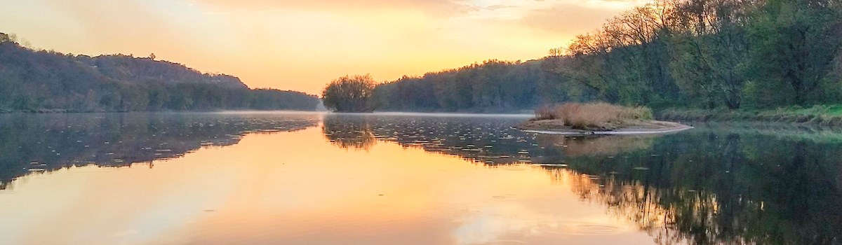 NPS photo | |
Free flowing and unpolluted, the Namekagon and St. Croix Rivers flow through some of the most scenic and least developed country in the Upper Midwest. Today 405 kilometers (252 miles) of these rivers are preserved as part of the National Wild and Scenic Rivers System. The St. Croix National Scenic Riverway, which includes the Namekagon, was established in 1968 as one of the original eight rivers under the National Wild and Scenic Rivers Act. The Lower St. Croix National Scenic Riverway was added to the system in 1972. Together they form a Riverway that offers outdoor enthusiasts a chance to enjoy a wilderness-like experience and a variety of outdoor recreation opportunities within easy reach of a major metropolitan area. On the upper St. Croix and Namakagon Rivers rapids challenge the canoeist, although none of the Riverway's waters are classified as whitewater. At the lower end, where the river widens out as Lake St. Croix, power and sail boating are popular. Campers, picnickers, swimmers, and birdwatchers enjoy its variety of scenes throughout. Anglers are attracted by the variety of fish lurking in the rivers, from trout and bass to muskellunge and sturgeon. The Riverway is managed through the cooperative efforts of the National Park Service, Minnesota and Wisconsin Departments of Natural Resources, and Northern States Power Company.
Upper St. Croix and Namakagon
The upper St. Croix and Namekagon part of the Riverway offers varied canoe environments on 322 kilometers (200 miles) of rivers. The Namekagon River begins at Namekagon Lake dam. It lies entirely in Wisconsin, flowing 158 kilometers (98 miles) south and west to join the St. Croix River near Danbury. The Namekagon begins as a narrow trout stream closed in by forest and meanders through a wide valley for much of its length. The river occasionally widens into marshy or swamplike areas popular for waterfowl watching. The lower Namekagon passes through an area of high sandy banks with many sharp bends. This stretch offers canoeists a wilderness-like experience because very little development is visible from the river. At four areas, dams form lake-like stretches called flowages. You can end canoe trips above these flowages, to avoid the slack water, or start below the dams, to avoid having to portage.
The St.Croix Riverway starts at a dam near Gordon, Wisconsin. It flows southerly for 164 kilometers (102 miles) to the dam at St. Croix Falls, Wisconsin. It lies in Wisconsin for its first 40 kilometers (25 miles) and then becomes the border river between Minnesota and Wisconsin until it flows into the Mississippi River. The St. Croix begins as a small spring. It is narrow and shallow until joined by its major tributary, the Namakagon, 32 kilometers (20 miles) downstream. It then becomes wider, deeper, and slower. For most of its length it flows through a wide valley with low banks, formed by the glacial activity that shaped both rivers' watersheds. The St. Croix passes two Minnesota State Parks that provide developed camping areas. (The Namekagon and upper St. Croix offer primitive sites.) The upper Riverway's last 16 kilometers (10 miles) are the Indianhead Flowage created by the 18-meter- (60-foot) high St. Croix Falls hydroelectric dam. Most canoeists take out upstream of the flowage to avoid the slack water. Small powerboat activities such as water skiing and deeper-water fishing take place on this flowage.
Many low and medium hazard rapids and a few high hazard rapids exist on the St. Croix and Namekagon Rivers, but they are not considered whitewater rivers. Recreation here includes fishing, hunting, inner tubing, picnicking, and canoeing, with small powerboating on the flowages. Most camping is at canoe-access primitive sites. Recreational vehicle camping areas can be found within the state parks or private campgrounds located near the Riverway.
Lower St. Croix
The Lower St. Croix National Scenic Riverway covers a narrow river and shoreline corridor for 84 kilometers (52 miles) from St. Croix Falls dam to Prescott, Wisconsin, where the river joins the Mississippi. The lower St. Croix is wider, deeper, and slower than the upper, its flow controlled by the hydroelectric dam at its upstream end. Downstream of the dam are the high cliffs of the Dalles, which formed as meltwaters from retreating glaciers cut a deep, vertical-walled gorge through bedrock. For about 3.2 kilometers (2 miles) here the St. Croix, in places 21-30 meters (70-100 feet) deep, flows its fastest. The Dalles mostly lie within two Interstate State Parks. Both offer short hiking trails to geologic features, and developed campgrounds, swimming beaches, picnic areas, and boat launch ramps. On the Minnesota side you can rent a canoe or take a boat tour to see the scenic Dalles from the best vantage point. right on the water.
As it leaves the Dalles, the river becomes wider and shallower and passes between high banks for the next 32 kilometers (20 miles). Although development is visible from the water for 24 kilometers (15 miles) on this stretch, it is popular with canoeists. The shallower water, lack of rapids, and absence of large powerboat waves make it suitable for beginning canoeists.
About 35 kilometers (22 miles) below the dam the Apple River flows into the St. Croix, creating a large sandbar. Near here the river becomes deeper and slower-moving. Large powerboating becomes the major use. Forty-three kilometers (27 miles) downstream the valley widens still more and, for the last 40 kilometers (25 miles) of Riverway, the river is known as Lake St. Croix. Here you enter the state-administered area. From near Stillwater, Minnesota, the Riverway's largest city, south to Afton, Minnesota, shoreline development is more visible and the area is classified recreational. Near Hudson, Wisconsin, south of Stillwater, the river reaches its maximum width, 2,255 meters (7,400 feet) and sailboating predominates. Further south the river passes two developing state parks, one on either side.
Recreation on the Lower St. Croix includes canoeing, fishing, powerboating, water skiing, and sailboating. Tour boat rides are offered at Interstate State Park near Taylor Falls, Minnesota, and at Stillwater. The three developed state parks offer developed campgrounds, hiking trails, picnic areas, and swimming beaches. Limited primitive campsites may be found on islands and various points along the shoreline. Special water-use regulations apply on the lower Riverway.
Past Ways of Life
Dakota and Chippewa Indians lived in this river and valley country for centuries before Europeans came. The country was rich in game, fish, wild rice, and other plant foods. It was also rich in beaver. and the Chippewa allied themselves with the first French trappers and traders. With French-supplied guns, the Chippewa eventually drove the Dakota Sioux onto the plains of southern Minnesota.
After beaver supplies declined and European markets went soft, the next big industry on the St. Croix was logging. Rivers here were once choked with logs. Spillways that canoeists now portage around once regulated the water for log drives. Dams were constructed to build a head of water to float the logs over falls and through narrows to downriver mills. A logjam in the narrow Dalles area in 1883 lasted 57 days. Loggers broke it up with dynamite. Seemingly endless forests created a boom economy for a time, but the last log drive went down the St. Croix in 1914.
The St Croix Mills was owned by Isaac Staples. The Staples residence sits on the hill.
Steamers plied the river for many commercial purposes. The steamer Cleon puts in at Taylor Falls beside a barge full of rock for building piers for the "Cedar Bend" railroad bridge. The Cleon was built in 1879 by Captain Oscar Knapp.
The Life of the River
Quiet pools, rapids, swamps, lakes the Riverway has many moods. The wild creatures you may discover change as the Riverway's habitats change. The mix of mostly recent-growth forests along the banks—pines, brush, and hardwoods—attracts deer. Marshes are favorite waterfowl haunts. There you may see wood ducks, mallards, or the great blue heron. Songbirds and small mammals abound throughout the Riverway.
With some luck you may see an osprey winging overhead. It is probably patrolling the river for fish, which it captures in its strong talons. The osprey is so large you might mistake it for the bald eagle—unless you see the birds together. The eagle is much larger.
For many people the Riverway is synonymous with canoe camping and fishing. Indeed it is a quiet, natural haven providing a relaxing change of pace. But the Riverway offers a variety of water and outdoor recreation opportunities along its length. For canoeists, a variety of trips is possible, from leisurely afternoon excursions to week-long expeditions.
Bass, muskellunge. and walleye pike can be caught in the St. Croix. The Namekagon is noted for its trout. Fishing is popular along the Riverway in part because of the many different species lurking in the waters. There is competition from other anglers and from various fishing birds and from the otter. While quietly fishing you may also see other small aquatic mammals the mink, beaver and muskrat. More elusive are the red and gray foxes, black bear and coyote. You may be startled if you flush an upland game bird such as the ruffed grouse, sharp-tailed grouse or the woodcock.
The upper part of the Riverway is canoe water, but the lower part is pleasure boat water. You may see powerboats large and small, sailboats, and even houseboats. Some of the powerboats will be towing water skiers. Houseboats reflect the easy-living pace of the river. This pace is wonderfully slow where the river widens out as Lake St. Croix.
Facilities, Safety Tips, and Regulations
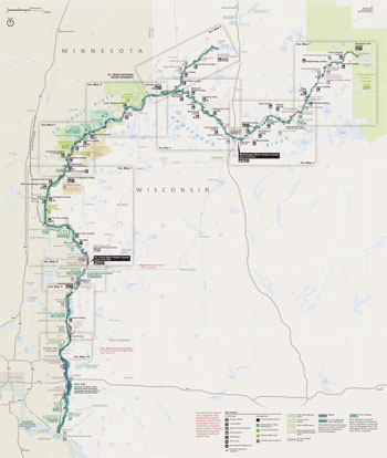 (click for larger map) |
Boaters and Canoers: All craft must be equipped with a USCG-approved lifesaving device for each person aboard. Nonswimmers should always wear them; everyone should in high-water conditions or when running rapids. Don't overload your craft. If you capsize in fast water, stay upstream from your canoe. Don't get caught between a swamped canoe and a rock or log! Boaters: watch your wake near canoes and your prop near swimmers.
Swimmers and Innertube Floaters: Don't swim alone, at night, or in unfamiliar places. Don't dive from bridges, high banks, or into water of unknown depth. Watch small children closely near water. There are no lifeguards or supervised beaches on the Riverway. Floaters: Wear a lifesaving device, float with others, and navigate rapids feet first.
Hikers: At the Riverway's several high-cliff areas, use caution and watch your footing near cliff edges. Parents: watch children closely near cliffs.
Fishing: A fishing license is required on the Riverway and state regulations apply. On the Namekagon and the first 40 kilometers (25 miles) of the St. Croix, a Wisconsin license is required. Where the St. Croix River is the boundary between Minnesota and Wisconsin, a license from either state is valid. State conservation officers and park rangers enforce regulations.
Fires and Firewood: Firewood is scarce near campsites; cutting trees or brush is prohibited. Build fires only in fire rings provided at campsites and keep them small. Never leave fire unattended and extinguish it completely before leaving the area.
Camping and Campsites: There are many primitive campsites on the Riverway. Camping above the Nevers Dam site north of St. Croix Falls is restricted to designated sites and limited to one night per site. Camping zones exist south of Nevers Dam site, where camping is restricted to seven nights. Please carry out trash; do not bury it.
Accommodations and Supplies: Accommodations and supplies are available in nearby communities. Commercial canoe outfitters are located along the Riverway.
Facilities: The Riverway Visitor Center and headquarters are located in St. Croix Falls, Wis. (open year round). The Marshland Visitor Center near Grantsburg, Wis., and the Namakagon Visitor Center at Trego, Wis., are open during the summer. Of the Riverway's several picnic areas, the two largest are in Earl Park on the Namekagon near Trego, and at Osceola Landing near Osceola, Wis., in the Lower St. Croix.
Fees: There are no fees for use of federally-owned land or facilities. The state parks charge entrance and camp fees. Daily and annual permits are available for the state parks.
Private Property: Some property along the rivers remains in private ownership. Respect the rights of landowners and do not disturb them or their property.
Cultural and Natural Features: It is illegal to disturb any natural features, such as rock formations, or cultural and archeological features, such as Indian burial mounds or remnants of historic structures. The gathering of any fruits, nuts, or plants for commercial purposes is prohibited.
Special Water Use Regulations: Boaters note: special "Slow Speed" and "Slow—No Wake" zones exist on the lower 84 kilometers (52 miles) of the St. Croix River. In some zones water skiing is prohibited after noon on weekends and holidays from Memorial Day weekend to Labor Day weekend. Complete regulations are available at marinas, state parks, or from water patrol people. Regulations are posted on bulletin boards at lower Riverway access points.
Lyme Disease: Deer ticks carry Lyme disease. Both are prevalent in the Riverway. Humans are infected through the bite of deer ticks. Visitors, especially hikers and campers, should check themselves for ticks. Take precautions and know the symptoms that may indicate an infection.
Administration: Three hundred sixty-five kilometers (227 miles) of St. Croix National Scenic Riverway are administered by the National Park Service. For information, write: Superintendent, P.O. Box 708, St. Croix Falls, WI 54024.
The St. Croix National Scenic Riverway is made up of the St. Croix and Namakagon rivers and the riparian setting through which they flow. Overall administration lies with the National Park Service, U.S. Department of the Interior. The lower St. Croix River below Stillwater, Minnesota, is administered by the Minnesota and Wisconsin Departments of Natural Resources as are five state parks, three state forests, and two wildlife refuges within the Federal zone. Douglas, Burnett, and Washburn Counties administer forest lands along the upper St. Croix and Namekagon rivers. Near Namekagon Lake, the river flows through the Chequamegon National Forest, and near the mouth of the Yellow River, the St. Croix flows by a portion of the reservation owned by the St. Croix Band of Chippewa.
Source: NPS Brochure (2000)
|
Establishment
Lower St. Croix National Scenic Riverway — October 25, 1972 (addition) |
For More Information Please Visit The  OFFICIAL NPS WEBSITE |
Documents
Acoustical Monitoring 2011: Saint Croix National Scenic Riverway NPS Natural Resource Technical Report NPS/NRSS/NRTR—2012/544 (Emma Lynch, February 2012)
Acoustic Monitoring Report: Saint Croix National Scenic Riverway NPS Natural Resource Report NPS/NRSS/NSNS/NRR—2014/890 (Misty D. Nelson, December 2014)
An Archeological Survey of Old Stinnet Bridge, Namekagon River, St. Croix National Scenic Riverway (Allen P. Van Dyke and Edgar S. Oerichbauer, October 1986)
An Archeological Survey of the St. Croix National Scenic Riverway: Phase I (Commonwealth Associates, Inc., April 1977)
An Archeological Survey of the St. Croix National Scenic Riverway: Phase II (Commonwealth Associates, Inc., May 1978)
Aquatic Studies in National Parks of the Upper Great Lakes States: Past Efforts and Future Directions NPS Technical Report NPS/NRWRD/NRTR-2005/334 (Brenda Moraska Lafrancois and Jay Glase, July 2005)
Bat Monitoring Protocol for the Great Lakes Inventory and Monitoring Network — Version 1.0 (NPS Natural Resource Report NPS/GLKN/NRR-2020/2126 (Katy G. Goodwin, May 2020)
Comprehensive River Management Plan (Newsletter): St. Croix National Scenic Riverway (2023)
Comprehensive River Management Plan (Newsletter Update): St. Croix National Scenic Riverway (November 2024)
Cultural Landscape Assessment: Arcola Bluffs and Fairy Falls, St. Croix National Scenic Riverway (November 21, 2018)
Contaminants in Bald Eagle Nestlings at Apostle Islands Lakeshore, Mississippi National River and Recreation Area, and the St. Croix National Scenic Riverway: Data Summary, 2006-2008 NPS Natural Resource Data Series NPS/GLKN/NRDS-2009/001 (Bill Route and Rebecca Key, June 2009)
Cooperative Management Plan, Lower St. Croix National Scenic Riverway, Minnesota and Wisconsin (January 2002)
Cooperative Management Plan/Environmental Impact Statement, Lower St. Croix National Scenic Riverway, Minnesota-Wisconsin Final (undated)
Forest Vegetation Monitoring at the St. Croix National Scenic Riverway NPS Natural Resource Technical Report NPS/GLKN/NRTR—2014/899 (Suzanne Sanders and Jessica Grochowski, August 2014)
Foundation Document, St. Croix National Scenic Riverway, Minnesota and Wisconsin (September 2017)
Foundation Document Overview, St. Croix National Scenic Riverway, Minnesota and Wisconsin (January 2017)
Interpretive Prospectus, Saint Croix National Scenic Riverway (1995)
Junior Ranger Activity Booklet, St. Croix National Scenic Riverway (2009; for reference purposes only)
Landsat-based Monitoring of Landscape Dynamics at Saint Croix National Scenic Riverway: 2005-2010 NPS Natural Resource Technical Report NPS/GLKN/NRTR—2013/715 (Alan A. Kirschbaum and Ulf B. Gafvert, March 2013)
Long-Range Interpretive Plan, St. Croix National Scenic Riverway (2005)
National Register of Historic Places Nomination Forms
21CH23 (Cathie Masters, April 5, 1988; Designated: January 16, 1989)
Croixsyde (Peggy Lindoo, October 3, 1977; Designated: June 3, 1980)
Franconia Historic District (Peggy Lindoo, October 3, 1977; Designated: June 17, 1980)
John Copas House (Peggy Lindoo, September 27, 1977; Designated: July 21, 1980)
Mower House and Arcola Mill Site (Peggy Lindoo, October 3, 1977; Designated: June 17, 1980)
Pest House (Peggy Lindoo, September 27, 1977; Designated: June 17, 1980)
Sandrock Cliffs (Cathie Masters, July 27, 1988; Designated: May 1, 1990)
St. Croix Boom Company House and Barn (Peggy Lindoo, October 3, 1977; Designated: June 3, 1980)
Natural Resource Condition Assessment, Saint Croix National Scenic Riverway NPS Natural Resource Report NPS/SACN/NRR-2015/1003 (George J. Kraft, Christine Mechenich, David J. Mechenich, James E. Cook and Jennifer L. McNelly, August 2015)
Park Newspaper (Two Rivers Journal/Guide): 1993 • 1998
Saving the Saint Croix: An Administrative History of the Saint Croix National Scenic Riverway (Theodore J. Karamanski, 1993)
Scenic River Study of the Lower Saint Croix River (February 1973)
Songbird Monitoring in the Great Lakes Network Parks: 2014-2018 NPS Natural Resource Report NPS/GLKN/NRR-2021/2217 (Samuel G. Roberts, Zachary S. Ladin, Elizabeth L. Tymkiw, W. Gregory Shriver and Ted Gostomski, January 2021)
St. Croix River Shoreline Studies 1995-2000 (Steve Johnson and Molly Shodeen, May 4, 1999)
Submerged Cultural Resources — Ruins of a Forgotten Highway: Issue 1 • 2 • 3 • 4 (2015)
Time and the River: A History of the Saint Croix National Scenic Riverway (HTML edition) (Eileen M. McMahon and Theodore J. Karamanski, 2002)
Vegetation Inventory Program: Saint Croix National Scenic Riverway, Minnesota/Wisconsin NPS Natural Resource Report NPS/GLKN/NRR—2012/547 (Kevin Hop, Sara Lubinski, Jennifer Dieck, Jim Drake and Shannon Menard, June 2012)
Water Quality Monitoring: 2011 Summary Report, St. Croix National Scenic Riverway NPS Natural Resource Data Series NPS/GLKN/NRDS—2012/366 (David VanderMeulen, September 2012)
Zooplankton Community Differences Among Four Main Pools of Lake St. Croix (Minnesota–Wisconsin): 2010–2011 NPS Natural Resource Report NPS/GLKN/NRR—2016/1267 (Toben Lafrancois, David VanderMeulen and Byron Karns, August 2016)
sacn/index.htm
Last Updated: 01-Jan-2025